Stratigraphy, Sedimentology, Paleontology, and Paleomagnetism of Pliocene-Early Pleistocene Lacustrine Deposits in Two Cores from Western Utah

Metadata also available as - [Outline] - [Parseable text] - [XML]

Frequently anticipated questions:


What does this data set describe?

Title:
Stratigraphy, Sedimentology, Paleontology, and Paleomagnetism of Pliocene-Early Pleistocene Lacustrine Deposits in Two Cores from Western Utah
Abstract:
The data contained in this report represent our preliminary findings of the analyses of two cores of Pliocene and early Pleistocene sediments from the eastern Great Basin. This is a collaborative project involving specialists from the USGS, Kansas State University, and the University of California-Davis in paleontology (Thompson, Buchner, Forester, Bradbury), stratigraphy and sedimentology (Oviatt, Kelsey, Bracht), and paleomagnetism and environmental magnetism (Roberts).
  1. How might this data set be cited?
    Thompson, Robert S., Oviatt, C.G., Roberts, A.P., Buchner, J., Kelsey, R., Bracht, C., Forester, R.M., and Bradbury, J.P., 1995, Stratigraphy, Sedimentology, Paleontology, and Paleomagnetism of Pliocene-Early Pleistocene Lacustrine Deposits in Two Cores from Western Utah: U.S. Geological Survey Open-File Report 95-1, U.S. Geological Survey, Denver, CO.

    Online Links:

  2. What geographic area does the data set cover?
    West_Bounding_Coordinate: -113.217
    East_Bounding_Coordinate: -112.950
    North_Bounding_Coordinate: 39.035
    South_Bounding_Coordinate: 38.715
  3. What does it look like?
    http://pubs.usgs.gov/of/1995/of95-001/2-material/fig1.gif (GIF)
    Locations of sites discussed in text. The shaded areas represent elevations above 6000 ft (1829 m). Woodland and forest vegetation generally occurs above this elevation, steppe and desert below.
    http://pubs.usgs.gov/of/1995/of95-001/3-black_rock/fig3.gif (GIF)
    Black Rock core stratigraphy plotted against the magnetostratigraphy, macrofossil occurrences, and magnetic susceptibility. BR = Brunhes, J = Jaramillo, C = Cobb Mountain, O = Olduvai, R = Reunion, X = Anomaly X, K = Kaena.
    http://pubs.usgs.gov/of/1995/of95-001/4-pit_of_death/fig9.gif (GIF)
    Pit of Death Stratigraphy. Br = Brunhes, J = Jaramillo, O = Olduvai, R = Réunion, X = Anomaly X.
    http://pubs.usgs.gov/of/1995/of95-001/4-pit_of_death/fig13.gif (GIF)
    Comparison of Black Rock and Pit of Death chronologies.
  4. Does the data set describe conditions during a particular time period?
    Calendar_Date: 1995
    Currentness_Reference:
    publication date
  5. What is the general form of this data set?
  6. How does the data set represent geographic features?
    1. How are geographic features stored in the data set?
    2. What coordinate system is used to represent geographic features?
      Horizontal positions are specified in geographic coordinates, that is, latitude and longitude. Latitudes are given to the nearest 1. Longitudes are given to the nearest 1. Latitude and longitude values are specified in Degrees, minutes, and decimal seconds.
      Vertical_Coordinate_System_Definition:
      Altitude_System_Definition:
      Altitude_Datum_Name: North American Vertical Datum of 1988
      Altitude_Resolution: 1
      Altitude_Distance_Units: feet
      Altitude_Encoding_Method:
      Explicit elevation coordinate included with horizontal coordinates
      Depth_System_Definition:
      Depth_Datum_Name: Local surface
      Depth_Resolution: 0.01
      Depth_Distance_Units: feet
      Depth_Encoding_Method: Explicit depth coordinate included with horizontal coordinates
  7. How does the data set describe geographic features?
    Paleomagnetic sample
    Oriented paleomagnetic samples are 2.5 x 2.5 x 1.5 cm. and were collected at 1 meter, (3.3 feet) intervals in both of the studied cores (Source: none)
    Paleomagnetic Inclination
    Angle at which magnetic field lines dip, measured in degrees from the horizontal. (Source: American Geological Institute Glossary of Geology)Frequency of measurement: None planned
    Range of values
    Minimum:0
    Maximum:90
    Units:Decimal degrees
    Resolution:0.1
    Entity_and_Attribute_Overview:

    Black Rock Core Log. Lithologic description containing information on grain size, color, bedding structures, sedimentary structures and occurance of plant-macrofossils.
    apx1.tab  1  Depth (feet)
    apx1.tab  2  Depth (meters)
    apx1.tab  3  Grain size description
    apx1.tab  4  Color of material
    apx1.tab  5  Bedding / sedimentary structures
    apx1.tab  6  Miscellaneous notes
    
    Black Rock Core Paleomagnetic Data. Paleomagnetic inclination measured by either Alternating Field demagnetization method or thermal demagnetization method.
    apx2.tab  1  Sample Label
    apx2.tab  2  Depth of sample (feet)
    apx2.tab  3  Depth of sample (meters)
    apx2.tab  4  Declination (degrees)
    apx2.tab  5  Inclination (degrees)
    apx2.tab  6  Delta (degrees)
    apx2.tab  7  Intensity
    apx2.tab  8  Polarity (Reversed/Not Reversed)
    apx2.tab  9  Method of Demagnetization (Thermal/Alternating Field)
    
    Black Rock Core Pollen Data. Counts of 57 pollen taxa from 159 samples from the Black Rock core.
    apx3.tab   1  Depth    (feet)
    apx3.tab   2  Sum      Terrestrial Pollen Sum
    apx3.tab   3  Abies    Abies count
    apx3.tab   4  Junip.   Juniperus-type count
    apx3.tab   5  Picea    Picea count
    apx3.tab   6  Pinus    Pinus count
    apx3.tab   7  Ps./La.  Pseudotsuga/Larix count
    apx3.tab   8  Ts.he.   Tsuga heterophylla count
    apx3.tab   9  Ve.un.   Vesiculate conifer undif. count
    apx3.tab  10  Ep.tr.   Ephedra trifurca-type count
    apx3.tab  11  Ep.vi.   Ephedra viridis-type
    apx3.tab  12  Acer     Acer count
    apx3.tab  13  Alnus    Alnus count
    apx3.tab  14  Arce.    Arceuthobium count
    apx3.tab  15  Betula   Betula count
    apx3.tab  16  Celtis   Celtis count
    apx3.tab  17  Cerc.    Cercocarpus-type count
    apx3.tab  18  Frax.    Fraxinus count
    apx3.tab  19  Frem.    Fremontodendron? count
    apx3.tab  20  Holo.    Holodiscus-type count
    apx3.tab  21  Popu.    Populus count
    apx3.tab  22  Pote.    Potentilla count
    apx3.tab  23  Pter.    Pterocarya? count
    apx3.tab  24  Quer.    Quercus count
    apx3.tab  25  Rham.    Rhamnaceae count
    apx3.tab  26  Rosa.    Rosaceae count
    apx3.tab  27  Salix    Salix count
    apx3.tab  28  Sh./E.   Shepherdia/Elaegnus count
    apx3.tab  29  Symp.    Symphoricarpos/Lonicera count
    apx3.tab  30  Ulmus    Ulmus count
    apx3.tab  31  Ambr.    Ambrosia-type count
    apx3.tab  32  Arte.    Artemisia count
    apx3.tab  33  Tubu.    Tubuliflorae count
    apx3.tab  34  Ligu.    Liguliflorae count
    apx3.tab  35  Ch.Am.   Chenopodiaceae/Amaranthus count
    apx3.tab  36  Sarc.    Sarcobatus count
    apx3.tab  37  Poac.    Poaceae count
    apx3.tab  38  Apia.    Apiaceae count
    apx3.tab  39  Bras.    Brassicaceae count
    apx3.tab  40  Cary.    Caryophyllaceae count
    apx3.tab  41  Erio.    Eriogonum count
    apx3.tab  42  Euph.    Euphorbiaceae count
    apx3.tab  43  Faba.    Fabaceae count
    apx3.tab  44  Gili.    Gilia-type count
    apx3.tab  45  Onag.    Onagraceae count
    apx3.tab  46  Phlox    Phlox count
    apx3.tab  47  Pole.    Polemonium count
    apx3.tab  48  Poly.    Polygonaceae count
    apx3.tab  49  Sola.    Solanaceae count
    apx3.tab  50  Thal.    Thalictrum count
    apx3.tab  51  Unkn.    Unknown count
    apx3.tab  52  Inde.    Indeterminate count
    apx3.tab  53  Mono.    Monlete spores count
    apx3.tab  54  Tril.    Trilete spores count
    apx3.tab  55  Cype.    Cyperaceae count
    apx3.tab  56  Myri.    Myriophyllum count
    apx3.tab  57  Ty.Sp.   Typha/Sparganium count
    apx3.tab  58  Pota.    Potamogeton count
    apx3.tab  59  Rupp.    Ruppia count
    apx3.tab  60  Botr.    Botryococcus count
    apx3.tab  61  Pedi.    Pediastrum count
    apx3.tab  62  Tracers  Tracers count
    
    Pit of Death Core Log. Lithologic description of the Pit of Death Core containing information on grain size, color, bedding structures, sedimentary structures and occurance of plant-macrofossils.
    apx4.tab  1  Depth (feet)
    apx4.tab  2  Depth (meters)
    apx4.tab  3  Grain size description
    apx4.tab  4  Color of material
    apx4.tab  5  Nature of boundary
    apx4.tab  6  Bedding / sedimentary structures
    apx4.tab  7  Miscellaneous notes
    
    Pit of Death Core Paleomagnetic Data. Paleomagnetic inclination measured by either Alternating Field demagnetization method or thermal demagnetization method.
    apx5.tab  1  Sample Label
    apx5.tab  2  Depth of sample (feet)
    apx5.tab  3  Depth of sample (meters)
    apx5.tab  4  Declination (degrees)
    apx5.tab  5  Inclination (degrees)
    apx5.tab  6  Delta (degrees)
    apx5.tab  7  Intensity
    apx5.tab  8  Polarity (Reversed/Not Reversed)
    apx5.tab  9  Method of Demagnetization (Thermal/Alternating Field)
    2-material/fig2.ps
    
    Vector component diagrams indicating representative demagnetizationbehavior of paleomagnetic samples.
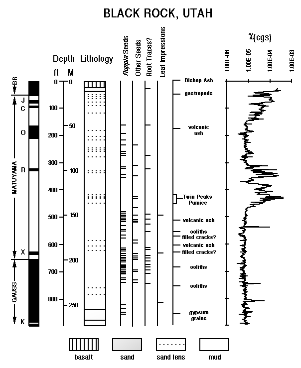
    http://pubs.usgs.gov/of/1995/of95-001/3-black_rock/fig3.gif
    http://pubs.usgs.gov/of/1995/of95-001/3-black_rock/fig3.ps
    
    Diagram showing paleomagnetic interpretation, lithology, occurance of seeds, occurance of root traces, occurance of leaf impressions and magnetic susceptibility in the Black Rock core.
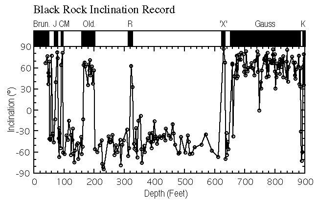
    http://pubs.usgs.gov/of/1995/of95-001/3-black_rock/fig4.gif
    http://pubs.usgs.gov/of/1995/of95-001/3-black_rock/fig4.ps
    
    Diagram showing the paleomagnetic inclination record of the Black Rock core.
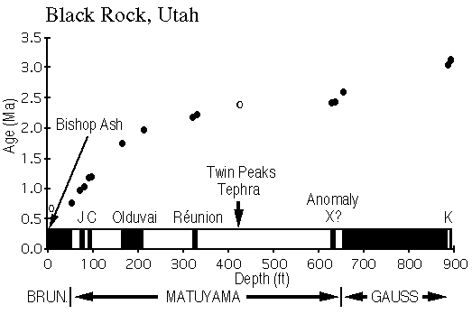
    http://pubs.usgs.gov/of/1995/of95-001/3-black_rock/fig5.gif
    http://pubs.usgs.gov/of/1995/of95-001/3-black_rock/fig5.ps
    
    Diagram showing age vs. depth relationship based on paleomagnetics and tephrochronology in the Black Rock Core.
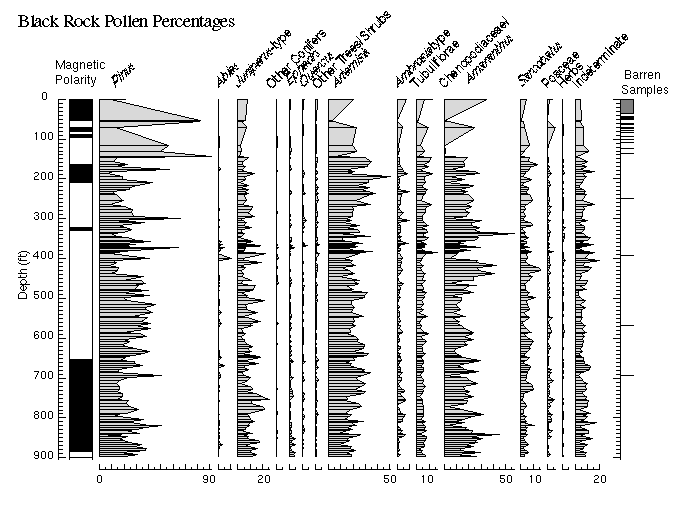
    http://pubs.usgs.gov/of/1995/of95-001/3-black_rock/fig6.gif
    http://pubs.usgs.gov/of/1995/of95-001/3-black_rock/fig6.ps
    
    Diagram showing paleomagnetic record and pollen percentages of 15 taxa in the Black Rock core.
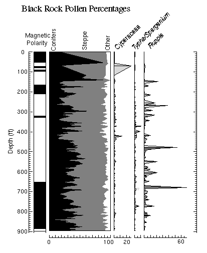
    http://pubs.usgs.gov/of/1995/of95-001/3-black_rock/fig7.gif
    http://pubs.usgs.gov/of/1995/of95-001/3-black_rock/fig7.ps
    
    Diagram showing paleomagnetic record and pollen summary diagram of Conifers vs. Steppe plants vs. Other taxa. vs aquatic pollen types occuring in the Black Rock Core
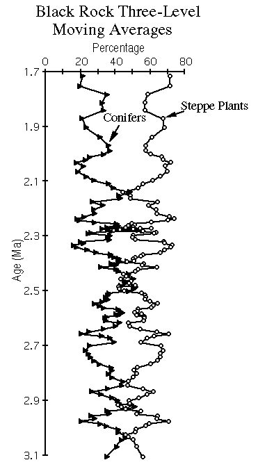
    http://pubs.usgs.gov/of/1995/of95-001/3-black_rock/fig8.gif
    http://pubs.usgs.gov/of/1995/of95-001/3-black_rock/fig8.ps
    
    Diagram of Three-level moving averages of conifer and steppe pollen from the Black Rock Core vs. time.
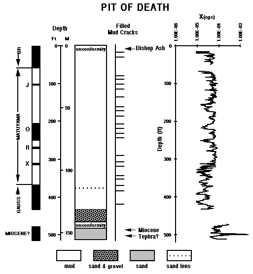
    http://pubs.usgs.gov/of/1995/of95-001/4-pit_of_death/fig9.gif
    http://pubs.usgs.gov/of/1995/of95-001/4-pit_of_death/fig9.ps
    
    Diagram showing paleomagnetic interpretation, lithology, occurance of mud cracks and magnetic susceptibility in the Pit of Death core.
    http://pubs.usgs.gov/of/1995/of95-001/4-pit_of_death/fig10.gif
    http://pubs.usgs.gov/of/1995/of95-001/4-pit_of_death/fig10.ps
    
    Diagram showing the paleomagnetic inclination record of the Pit of Death core.
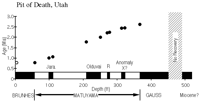
    http://pubs.usgs.gov/of/1995/of95-001/4-pit_of_death/fig11.gif
    http://pubs.usgs.gov/of/1995/of95-001/4-pit_of_death/fig11.ps
    
    Diagram showing age vs. depth relationship based on paleomagnetics and tephrochronology in the Pit of Death Core.
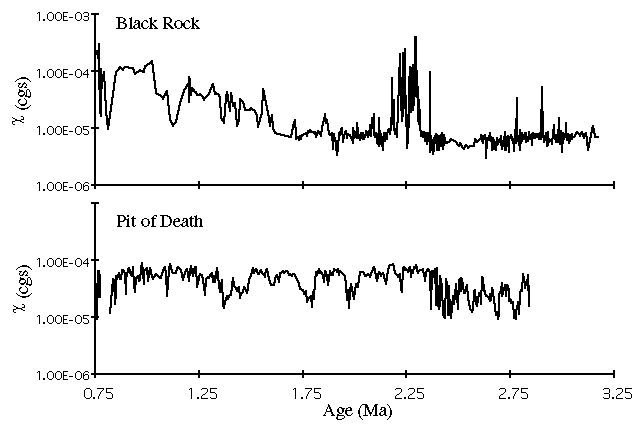
    http://pubs.usgs.gov/of/1995/of95-001/4-pit_of_death/fig12.gif
    http://pubs.usgs.gov/of/1995/of95-001/4-pit_of_death/fig12.ps
    
    Diagram comparing the magnetic susceptibiliy records of the Black Rock and Pit of Death cores.
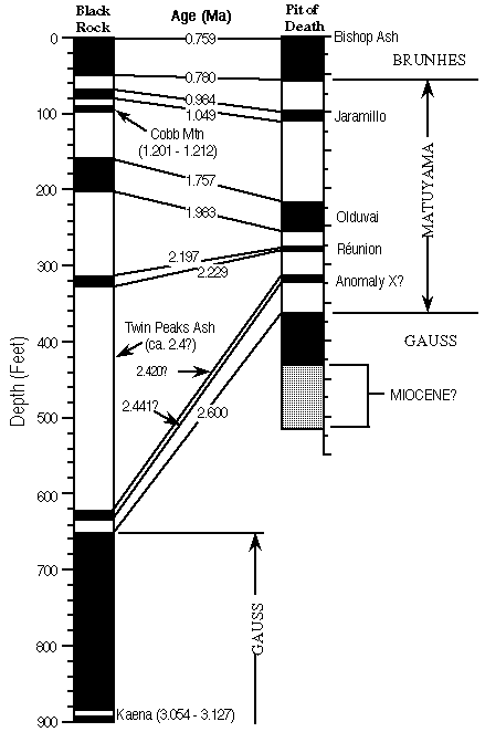
    http://pubs.usgs.gov/of/1995/of95-001/4-pit_of_death/fig13.gif
    http://pubs.usgs.gov/of/1995/of95-001/4-pit_of_death/fig13.ps
    
    Diagram comparing the chronologies and depositional rates of the Black Rock and Pit of Death cores.
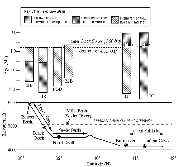
    http://pubs.usgs.gov/of/1995/of95-001/5-discussion/fig14.gif
    http://pubs.usgs.gov/of/1995/of95-001/5-discussion/fig14.ps
    
    Diagram comparing the lacustrine histories of Pliocene through Pleistocene sites in western Utah.
    Paleoenvironmental interpretations summarizing the analysis of approximately 900 ostracode samples from the Black Rock core.
    Summary of results of analysis of 10 ostracode samples from the Pit of Death core.
    Entity_and_Attribute_Detail_Citation: http://pubs.usgs.gov/of/1995/of95-001/of95-001.html

Who produced the data set?

  1. Who are the originators of the data set? (may include formal authors, digital compilers, and editors)
    • Robert S. Thompson
    • C.G. Oviatt
    • A.P. Roberts
    • J. Buchner
    • R. Kelsey
    • C. Bracht
    • R.M. Forester
    • J.P. Bradbury
  2. Who also contributed to the data set?
    This report is the preliminary result of a collaborative project involving specialists from the USGS, Kansas State University, and the University of California-Davis in paleontology (Robert S. Thompson, Jennifer Rose Buchner, R.M. Forester, J.P. Bradbury), stratigraphy and sedimentology (Charles G. Oviatt, Rachel Kelsey, Christopher Bracht), and paleomagnetism and environmental magnetism (Andrew P. Roberts).
  3. To whom should users address questions about the data?
    Robert S. Thompson
    U.S. Geological Survey
    Geologist
    Box 25046, Mail Stop 919
    Denver Federal Center
    Denver, CO
    USA

    303-236-5347 (voice)
    303-236-5349 (FAX)
    rthompson@usgs.gov

Why was the data set created?

We are investigating the paleoclimatic history of western Utah as part of the USGS Global Change and Climate History Program studies of long-term climatic changes in the western United States. Our initial objective is to document the environmental conditions during the mid-Pliocene period of warmer-than-modern global climates (the focus of the USGS Pliocene Research, Interpretation, and Synoptic Mapping [PRISM] project). We also seek to determine how and when these conditions gave way to the late Quaternary pattern of climatic variations (in which short periods of very moist climates have been separated by long periods of arid conditions).

How was the data set created?

  1. From what previous works were the data drawn?
    Billings (1949) (source 1 of 20)
    Billings, W.D., 1949, The shadscale vegetation zone of Nevada and eastern California in relation to climate and soils: American Midland Naturalist v. 42, p. 87-109.

    Type_of_Source_Media: paper
    Source_Contribution: Ecology of shadescale vegetation
    Cande and Kent (1992) (source 2 of 20)
    Cande, S.C., and Kent, D.V, 1992, A new geomagnetic polarity time scale for the Late Cretaceous and Cenozoic: Journal of Geophysical Research v. 97, p. 13, 917-13,951.

    Type_of_Source_Media: paper
    Source_Contribution: Paleomagnetic framework
    Canfield and Berner (1987) (source 3 of 20)
    Canfield, D.E., and Berner, R.A., 1987, Dissolution and pyritization of magnetite in anoxic marine sediments: Geochimica et Cosmochimica Acta v. 51, p. 645-659..

    Type_of_Source_Media: paper
    Source_Contribution: Chemistry of magnetic minerals in reducing environments.
    Condie and Barsky (1972) (source 4 of 20)
    Condie, K.C., and Barsky, C.K., 1972, Origin of the Quaternary basalts from the Black Rock Desert region, Utah: Geological Society of America Bulletin v. 83, p. 333-352..

    Type_of_Source_Media: paper
    Source_Contribution: K-Ar dates on the Black Rock basalt
    Crecraft, Nash and Evans (1981) (source 5 of 20)
    Crecraft, H. R., Nash, W. P., and Evans, S. H., Jr., 1981, Late Cenozoic volcanism at Twin Peaks, Utah - Geology and petrology: Journal of Geophysical Research v. 86: p. 10,303-10,320.

    Type_of_Source_Media: paper
    Source_Contribution:
    K-Ar dates on Black Rock Basalt Paleotectonic framework
    Cui et al. (1994) (source 6 of 20)
    Cui, Y., Roberts, A.P, Verosub, K.L., Thompson, R.S., and Oviatt, C.G., 1994, A Study of the Matuyama-Brunhes Geomagnetic Polarity Transition From Sevier Lake, Utah [abs.]: EOS, Transactions of the American Geophysical Union v. 75, p. 194-195.

    Type_of_Source_Media: paper
    Source_Contribution: Magnetostratigraphy
    Davis (1984) (source 7 of 20)
    Davis, O.K., 1984, Pollen frequencies reflect vegetation patterns in a Great Basin (U.S.A.) mountain range: Review of Palaeobotany and Palynology v. 40, p. 295-315..

    Type_of_Source_Media: paper
    Source_Contribution: Regional studies of modern pollen rain
    Davis (1993) (source 8 of 20)
    Davis, O.K., 1993, Preliminary pollen analysis of Neogene sediment of the Great Salt Lake, U.S.A [abs]: American Association of Stratigraphic Palynologists, Inc., Program and Abstracts 1993 Annual Meeting, Baton Rouge, LA, p. 20..

    Type_of_Source_Media: paper
    Source_Contribution: Palynological data from Indian Cove, Great Salt Lake
    DeMenocal, Ruddiman and Kent (1990) (source 9 of 20)
    DeMenocal, P.B., Ruddiman, W.F., and Kent, D.V., 1990, Depth of post-depositional remanence acquisition in deep-sea sediments: a case study of the Brunhes-Matuyama reversal and oxygen isotope stage 19.1: Earth and Planetary Science Letters v. 99, p. 1-13.

    Type_of_Source_Media: paper
    Source_Contribution: Magnetic remanence acquisition in sediments.
    Eardley, et al (1973) (source 10 of 20)
    Eardley, A.J., Shuey, R.T., Gvosdetsky, V., Nash, W.P., Picard, M.D., Grey, D.C., and Kukla, G.J., 1973, Lake cycles in the Bonneville Basin, Utah: Geological Society of America Bulletin v. 84, p. 211-216.

    Type_of_Source_Media: paper
    Source_Contribution: Climatological interpretation of correlative cores
    Machette (1985) (source 11 of 20)
    Machette, M. N., 1985, Late Cenozoic geology of the Beaver basin, southwestern Utah: Brigham Young University Geology Studies v. 32, pt. 1, p. 19-37..

    Type_of_Source_Media: paper
    Source_Contribution:
    Paleohydrology of the Beaver River and the Sevier River drainage systems.
    Oviatt (1991) (source 12 of 20)
    Oviatt, C. G., 1991, Quaternary geology of the Black Rock Desert, Millard County, Utah: Utah Geological and Mineral Survey Special Studies 73, 23 p..

    Type_of_Source_Media: paper
    Source_Contribution: Paleotectonic framework
    Oviatt (1992) (source 13 of 20)
    Oviatt, C. G., 1992, Quaternary geology of the Scipio Valley area, Millard and Juab Counties, Utah: Utah Geological Survey Special Study no. 79, 16 p..

    Type_of_Source_Media: paper
    Source_Contribution: Depositional history of the Sevier River drainage
    Oviatt (1994) (source 14 of 20)
    Oviatt, C. G., 1994, Review of the Quaternary geology of the Sevier and Black Rock Deserts: Utah Geological Association Publication v. 23, p. 97-103..

    Type_of_Source_Media: paper
    Source_Contribution: Stratigraphic framework
    Roberts and Turner (1993) (source 15 of 20)
    Roberts, A.P., and Turner, G.M., 1993, Diagenetic formation of ferrimagnetic iron sulphide minerals in rapidly deposited marine sediments.: Earth and Planetary Science Letters v. 115, p. 257-273..

    Type_of_Source_Media: paper
    Source_Contribution: Chemistry of magnetic minerals in reducing environments.
    Thompson (1991) (source 16 of 20)
    Thompson, Robert S., 1991, Pliocene environments and climates in the western United States: Quaternary Science Reviews v. 10, p. 115-132..

    Type_of_Source_Media: paper
    Source_Contribution: Climatological interpretation of the Pliocene pollen record
    Thompson (in press) (source 17 of 20)
    Thompson, R.S., 1996, Pliocene and early Pleistocene environments and climates of the western Snake River Plain, Idaho: Marine Micropaleontology 1996.

    Type_of_Source_Media: paper
    Source_Contribution: Late Gauss Chron pollen data from southern Idaho
    Vance and Mathewes (1994) (source 18 of 20)
    Vance, R.E., and Mathewes, R.W., 1994, Deposition of modern pollen and plant macrofossils in a hypersaline prairie lake basin: Canadian Journal of Botany v. 72, p. 539-548..

    Type_of_Source_Media: paper
    Source_Contribution: Palynological framework
    Verosub and Roberts (in press) (source 19 of 20)
    Verosub, K.L., and Roberts, A.P., 1996, Environmental magnetism: past, present, and future: Journal of Geophysical Research in press.

    Type_of_Source_Media: paper
    Source_Contribution: Magnetostratigraphic correlation of lake-catchment sediments.
    Williams (1994) (source 20 of 20)
    Williams, S.K., 1994, Late Cenozoic tephrostratigraphy of deep sediment cores from the Bonneville Basin, northwest Utah: Geological Society of America Bulletin v. 105, p. 1517-1530..

    Type_of_Source_Media: paper
    Source_Contribution: Climatological interpretation of correlative core material
  2. How were the data generated, processed, and modified?
    Date: 30-Sep-1993 (process 1 of 9)
    Core collection and curation. The Black Rock and Pit of Death sediment cores were drilled in July, August, and September of 1993 with a Portadrill 524-3A rotary drilling rig that took a 3" (7.62 cm) diameter core. The cores are archived at the USGS Core Repository on the Denver Federal Center. The coring equipment and original records are in English units, and to maintain continuity with those records, core depths are reported here in English units. Person who carried out this activity:
    C. G. Oviatt
    Department of Geology, Kansas State University
    Geologist
    Department of Geology, Kansas State University
    Manhattan, Kansas

    913-532-6724 (voice)
    joviatt@ksuvm.ksu.edu
    Date: Unknown (process 2 of 9)
    Ostracode Analysis. Sediment samples for ostracode analysis were split into two fractions, a larger fraction for isotopic analysis of ostracode shells (~15 g) and a smaller fraction for ostracode counts (~5 g). The samples were subjected to a freeze/thaw process to disaggregate clay particles and then washed with hot water over a 100 mm mesh screen. Approximately 920 samples have been prepared from the Black Rock core, and 10 from the Pit of Death Core. Person who carried out this activity:
    R.M. Forester
    U.S. Geological Survey
    Mail Stop 919
    Box 25046
    Denver Federal Center
    Denver, Colorado

    (303) 236-5656 (voice)
    forester@usgs.gov
    Date: Unknown (process 3 of 9)
    Stratigraphy and sedimentology. Core sediments were logged in the field, and the stratigraphy and sedimentology was studied in greater detail in the laboratory by Oviatt and Kelsey (Black Rock) and Oviatt and Bracht (Pit of Death). These researchers have analyzed samples for carbonate, sand, and mud contents at approximately one-foot (30 cm) intervals throughout both cores. X-ray analysis is on-going for carbonate minerals from representative samples from both cores. Person who carried out this activity:
    C. G. Oviatt
    Department of Geology, Kansas State University
    Geologist
    Department of Geology, Kansas State University
    Manhattan, Kansas

    913-532-6724 (voice)
    joviatt@ksuvm.ksu.edu
    Date: Unknown (process 4 of 9)
    Paleomagnetic Analysis. Oriented paleomagnetic samples were taken by carving pedestals into the cores and slipping plastic boxes (2.5 x 2.5 x 1.5 cm) over the pedestals. In general, samples were collected at 1 m (3.3 ft) intervals throughout the length of both cores.For paleomagnetic studies, 307 and 139 samples were analyzed from the Black Rock and Pit of Death cores respectively. The samples were stepwise demagnetized by either alternating field (AF) or thermal methods. AF demagnetization was generally carried out at successive peak fields of 0, 10, 20, 25, 40, and 60 mT, and in some cases, additional intermediate steps were included at peak fields of 5, 15, 30, and 50 mT. Thermal demagnetization was carried out at successive steps of 20, 50, 100, 150, 200, 250, 300, 350, 400, 450, 500, 550, and 600 degrees C. Magnetic susceptibility was measured at each thermal demagnetization level to monitor for thermal alteration. Remanence measurements were made on a 2G Enterprises cryogenic magnetometer. AF demagnetization was carried out with a Schonstedt AF demagnetizer and thermal demagnetization was carried out with a Schonstedt thermal demagnetizing unit. Magnetic susceptibility was measured with a Bartington Instruments magnetic susceptibility meter.
    Characteristic remanence directions were determined from stably magnetized samples by linear regression fits to the demagnetization data. Three types of demagnetization behavior are evident and are designated as types A, B, and C. Type A behavior is displayed by demagnetization data that decay to the origin of vector component plots with little deviation from linearity (Figure 2a, d). Type B behavior is displayed by samples that yield more scattered demagnetization data, nevertheless, the direction of magnetization can be unambiguously determined (Figure 2b, e). Type C behavior is displayed by samples for which no stable direction of remanence, or even an indication of polarity, can be determined (Figure 2c, f). In general, the data quality from the Pit of Death core are of substantially higher quality than those from the Black Rock core. Of the 139 samples analyzed from the Pit of Death core, 81%, 16%, and 3% of the samples displayed behavior of types A, B, and C, respectively. Of the 307 samples analyzed from the Black Rock core, 17%, 54%, and 29% of the samples displayed behavior of types A, B, and C,respectively. The Black Rock and Pit of Death cores were azimuthally unoriented. The paleomagnetic polarity was therefore determined solely from inclination data. All ages of paleomagnetic datums follow those of Cande and Kent (1992). Person who carried out this activity:
    Andrew P. Roberts
    Department of Geology
    University of California
    Davis, CA 95616, California
    United States of America

    (916) 752-1861 (voice)
    Roberts@geology.ucdavis.edu
    Date: Unknown (process 5 of 9)
    Magnetic susceptibility. The magnetic susceptibility of the Black Rock and Pit of Death core sediments was measured by analyzing selected depth intervals with a Sapphire whole-core pass-through susceptometer. For susceptibility studies, 766 levels were measured from the Black Rock core and 411 from the Pit of Death core. Person who carried out this activity:
    Andrew P. Roberts
    Department of Geology
    University of California
    Davis, CA 95616, California

    (916) 752-1861 (voice)
    Roberts@geology.ucdavis.edu
    Date: Unknown (process 6 of 9)
    Palynological Analysis. Sediment samples from the Black Rock and Pit of Death cores were processed with chemical reagents (HCl, HF, heavy liquids) to remove unwanted mineral materials. The sample residues were analyzed under 400X to 1000X magnification, and a minimum of 300 terrestrial pollen grains were counted from each sample (except for samples above ~150 ft in the Black Rock core, where pollen concentrations were so low that only 200 grain counts were possible). Of the 159 samples processed from the Black Rock site, 142 contained sufficient pollen for analysis. Ten samples were processed from the Pit of Death core, and all were barren of pollen. Person who carried out this activity:
    Robert S. Thompson
    U.S. Geological Survey
    Box 25046, Mail Stop 919
    Denver Federal Center
    Denver, Colorado

    (303) 236-0439 (voice)
    (303) 236-5690 (FAX)
    rthompson@usgs.gov
    Date: Unknown (process 7 of 9)
    Diatom Analysis. Preliminary analysis of diatoms from the two cores were conducted using water mounts of unprocessed sediment smears. Twenty-four samples have been analyzed from the Black Rock core and 10 from the Pit of Death core. Person who carried out this activity:
    J.P. Bradbury
    U.S. Geological Survey
    Mail Stop 919
    Box 25046
    Denver Federal Center
    Denver, Colorado

    (303) 236-5666 (voice)
    jbradbur@usgs.gov
    Date: Unknown (process 8 of 9)
    Plant macrofossil Analysis. Seeds and leaf fragments and Ruppia and other plants are present throughout most of the Black Rock core. The occurrences of these plant macrofossils have been recorded during the sediment descriptions and by examination of slides prepared for ostracode analysis. Person who carried out this activity:
    Robert S. Thompson
    U.S. Geological Survey
    Box 25046, Mail Stop 919
    Denver Federal Center
    Denver, Colorado

    (303) 236-0439 (voice)
    (303) 236-5690 (FAX)
    rthompson@usgs.gov
    Date: 20-Jul-2010 (process 9 of 9)
    Creation of original metadata record Person who carried out this activity:
    Kevin M. Foley
    Mail Stop 918
    U.S. Geological Survey
    12201 Sunrise Valley Drive
    Reston, VA

    (703) 648-5285 (voice)
    (703) 648-6560 (FAX)
    kfoley@usgs.gov
  3. What similar or related data should the user be aware of?

How reliable are the data; what problems remain in the data set?

  1. How well have the observations been checked?
    Accuracy of measurements and processes is discussed in detail in the "Materials and Methods" section of the report.
  2. How accurate are the geographic locations?
    The horizontal coordinates of the drilling sites are given in degrees, minutes and seconds of latitude and longitude. A second of longitude at 39 degrees latitude is approximately 19.45 meters. A second of latitude is approximately 30.92 meters. This suggests that the longitude of the sites is known to within 19.45 meters and the latitude of the sites is known to within 30.92 meters.
  3. How accurate are the heights or depths?
    The elevation of the Black Rock site is given as 4930 feet and the elevation of the Pit of Death site is given as 4535 feet. This suggests that the measurements are accurate to within 5 vertical feet.
    Core logs (Appendix 1, Appendix 4) indicate that the drilling machinery indicated drilling depth in increments of 1/100th of a foot.
  4. Where are the gaps in the data? What is missing?
    Core Collection
    Black Rock Core
    Approximately 8 ft (2.4 m) of tan silt overlies 17 ft (5.2 m) of basalt at the Black Rock site. The coring process did not recover any of the silt or basalt (although some of the silt was recovered in Shelby tubes), nor was it possible to recover the uppermost few feet of sediment underlying the basalt. Core recovery began at 25.25 ft (7.7 m) and extended down to 896.83 ft (273.35 m). As shown in Appendix 1, core recovery was excellent throughout most of this depth range.
    Pit of Death Core
    The only unrecovered section of significant thickness in the Pit of Death core is near the bottom. Pebbly mud in the interval between 428 and 431 ft overlies an interval of about 40 ft of sand and gravel, from which no core was recovered. From 472 ft to the base of the core at 512 ft, is a sequence of moderately cemented, poorly sorted, tuffaceous sand.
    Palynological Analysis
    Of the 159 samples processed from the Black Rock site, 142 contained sufficient pollen for analysis. Ten samples were processed from the Pit of Death core, and all were barren of pollen.
    Plant Macrofossil Analysis
    The occurrences of these plant macrofossils has been recorded during the sediment descriptions and by examination of slides prepared for ostracode analysis.
    Ostracode Analysis
    Approximately 920 samples have been prepared from the Black Rock core, and 10 from the Pit of Death Core.
    Diatom Analysis
    Twenty-four samples have been analyzed from the Black Rock core and 10 from the Pit of Death core.
  5. How consistent are the relationships among the observations, including topology?
    Coring equipment and original logs record core depths for both cores in the English units of "decimal feet". The depths recorded in the Metric units of "meters" were calculated from the English measurements.
    Both alternating-field and thermal methods were used for demagnetization of paleomagnetic samples. When the thermal method was used, magnetic susceptibility was measured at each demagnetization step to monitor for thermal alteration.

How can someone get a copy of the data set?

Are there legal restrictions on access or use of the data?
Access_Constraints: None
Use_Constraints: None
  1. Who distributes the data set? (Distributor 1 of 1)
    Kevin M. Foley
    Global Climate History Program, U.S. Geological Survey
    Mail Stop 918
    U.S. Geological Survey
    12201 Sunrise Valley Drive
    Reston, Virginia

    (703) 648-5285 (voice)
    (703) 648-6560 (FAX)
    kfoley@usgs.gov
  2. What's the catalog number I need to order this data set? U.S. Geological Survey Open-File Report 95-1
  3. What legal disclaimers am I supposed to read?
    This report is preliminary and has not been reviewed for conformity with U.S. Geological Survey editorial standards (or with the North American Stratigraphic Code). Any use of trade, product, or firm names is for descriptive purposes only and does not imply endorsement by the U.S. Government.
  4. How can I download or order the data?
    • Availability in digital form:
      Data format: The information is structured and formatted for retrieval using web browsers. in format ASCII
      Network links: http://pubs.usgs.gov/of/1995/of95-001/
    • Cost to order the data: none


Who wrote the metadata?

Dates:
Last modified: 13-Jun-2016
Metadata author:
Peter N Schweitzer
USGS Midwest Area
Collection manager, USGS Geoscience Data Clearinghouse, http://geo-nsdi.er.usgs.gov/
Mail Stop 954
12201 Sunrise Valley Dr
Reston, VA
USA

703-648-6533 (voice)
703-648-6252 (FAX)
pschweitzer@usgs.gov
Metadata standard:
Content Standard for Digital Geospatial Metadata (FGDC-STD-001-1998)

This page is <https://geo-nsdi.er.usgs.gov/metadata/open-file/95-1/metadata.faq.html>
Generated by mp version 2.9.48 on Tue Jul 03 20:06:31 2018