Abstract:
This Open-File report is a digital physiographic map database.
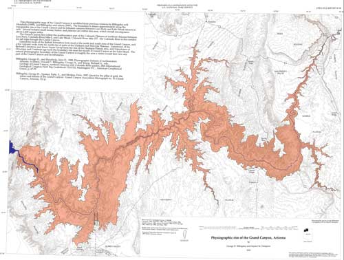
This physiographic map of the Grand Canyon is modified from
previous versions by Billingsley and Hendricks (1989), and
Billingsley and others (1997). The boundary is drawn approximately
along the topographic rim of the Grand Canyon and its tributary
canyons between Lees Ferry and Lake Mead (shown in red). Several
isolated small mesas, buttes, and plateaus are within this area,
which overall encompasses about 2,600 square miles.
The Grand Canyon lies within the southwestern part of the Colorado Plateaus of northern Arizona between Lees Ferry, Colorado River Mile 0, and Lake Mead, Colorado River Mile 277. Limestone rocks of the Kaibab Formation form most of the north and south rims of the Grand Canyon, and a few volcanic rocks form the north rim of parts of the Uinkaret and Shivwits Plateaus. Limestones of the Redwall Limestone and lower Supai Group form the rim of the Hualapai Plateau area, and Limestones of Devonian and Cambrian age form the boundary rim near the mouth of Grand Canyon at the Lake Mead. The natural physiographic boundary of the Grand Canyon is roughly the area a visitor would first view any part of the Grand Canyon and its tributaries.
Purpose:
This pamphlet serves to introduce and describe the digital data. There is no paper map included in the Open-File report. The report does include, however, PostScript and PDF format plot files, each containing an image of the map.
Supplemental_Information:
ARC/INFO export file  Description of Coverage
border.e00            Map border
county.e00            County boundaries
grndcynhyp.e00        Contours (hypsography) from the U.S. Geological Survey 1:100,000 Cameron quadrangle (1982), Fredonia (1984), Glen Canyon (1984), Grand Canyon (1984), Peach Springs (1986), Mount Trumbull (1986), Tuba City (1983), and Valle (1983)
majorstreets.e00      Roads
rim.e00               Physiographic rim of the Grand Canyon
river.e00             Colorado river and tributaries
town.e00              Towns
Theme:
Theme_Keyword_Thesaurus: USGS Thesaurus
Theme_Keyword: geolography
Theme_Keyword: maps and atlases
Theme_Keyword: geospatial datasets
Theme:
Theme_Keyword_Thesaurus: National Geologic Map Database Catalog themes, augmented
Theme_Keyword: 3400 - Graphical
Theme_Keyword: 3410 - PDF
Theme_Keyword: 3100 - Vector
Theme_Keyword: 3110 - ESRI
Theme_Keyword: 3111 - coverage
Theme_Keyword: 1100 - Geology
Theme_Keyword: 1101 - General
Theme:
Theme_Keyword_Thesaurus: ISO 19115 Topic Categories
Theme_Keyword: geoscientificInformation
Place:
Place_Keyword_Thesaurus: Augmented FIPS 10-4 and FIPS 6-4
Place_Keyword: f04005 = Coconino
Place_Keyword: f04015 = Mohave