Physiographic Rim of The Grand Canyon, Arizona: A Digital Database

Metadata also available as - [Outline] - [Parseable text] - [XML]

Frequently anticipated questions:


What does this data set describe?

Title:
Physiographic Rim of The Grand Canyon, Arizona: A Digital Database
Abstract:
This Open-File report is a digital physiographic map database. This physiographic map of the Grand Canyon is modified from previous versions by Billingsley and Hendricks (1989), and Billingsley and others (1997). The boundary is drawn approximately along the topographic rim of the Grand Canyon and its tributary canyons between Lees Ferry and Lake Mead (shown in red). Several isolated small mesas, buttes, and plateaus are within this area, which overall encompasses about 2,600 square miles.
The Grand Canyon lies within the southwestern part of the Colorado Plateaus of northern Arizona between Lees Ferry, Colorado River Mile 0, and Lake Mead, Colorado River Mile 277. Limestone rocks of the Kaibab Formation form most of the north and south rims of the Grand Canyon, and a few volcanic rocks form the north rim of parts of the Uinkaret and Shivwits Plateaus. Limestones of the Redwall Limestone and lower Supai Group form the rim of the Hualapai Plateau area, and Limestones of Devonian and Cambrian age form the boundary rim near the mouth of Grand Canyon at the Lake Mead. The natural physiographic boundary of the Grand Canyon is roughly the area a visitor would first view any part of the Grand Canyon and its tributaries.
Supplemental_Information:
ARC/INFO export file  Description of Coverage
border.e00            Map border
county.e00            County boundaries
grndcynhyp.e00        Contours (hypsography) from the U.S. Geological Survey 1:100,000 Cameron quadrangle (1982), Fredonia (1984), Glen Canyon (1984), Grand Canyon (1984), Peach Springs (1986), Mount Trumbull (1986), Tuba City (1983), and Valle (1983)
majorstreets.e00      Roads
rim.e00               Physiographic rim of the Grand Canyon
river.e00             Colorado river and tributaries
town.e00              Towns
  1. How might this data set be cited?
    Billingsley, G.H., and Hampton, H.M., 1999, Physiographic Rim of The Grand Canyon, Arizona: A Digital Database: U.S. Geological Survey Open-File Report 99-30.

    Online Links:

  2. What geographic area does the data set cover?
    West_Bounding_Coordinate: -144.00
    East_Bounding_Coordinate: -111.50
    North_Bounding_Coordinate: 37.00
    South_Bounding_Coordinate: 35.50
  3. What does it look like?
    http://pubs.usgs.gov/of/1999/0030/images/coverthb.jpg (JPEG)
    Reduced-size image of the map sheet, 500x378 pixels
    http://pubs.usgs.gov/of/1999/0030/pdf/gcrim.pdf (PDF)
    A PDF representation of the physiographic rim of the Grand Canyon, Arizona
  4. Does the data set describe conditions during a particular time period?
    Calendar_Date: 1999
    Currentness_Reference:
    publication date
  5. What is the general form of this data set?
    Geospatial_Data_Presentation_Form: map
  6. How does the data set represent geographic features?
    1. How are geographic features stored in the data set?
      This is a vector data set. It contains the following vector data types (SDTS terminology):
      • entity point
      • complete chain
      • GT-polygon composed of chains
    2. What coordinate system is used to represent geographic features?
      Grid_Coordinate_System_Name: Universal Transverse Mercator
      Universal_Transverse_Mercator:
      UTM_Zone_Number: 12
      Transverse_Mercator:
      Scale_Factor_at_Central_Meridian: 0.9996
      Longitude_of_Central_Meridian: -111
      Latitude_of_Projection_Origin: 0.0
      False_Easting: 500000
      False_Northing: 0.0
      Planar coordinates are encoded using coordinate pair
      Planar coordinates are specified in meters
      The horizontal datum used is NAD27.
      The ellipsoid used is Clarke 1866.
      The semi-major axis of the ellipsoid used is 6378206.4.
      The flattening of the ellipsoid used is 1/294.98.
  7. How does the data set describe geographic features?
    MAJORSTREETS.AAT
    Roads (Source: OFR-99-30)
    FNAME
    Name of road (Source: OFR-99-30)
    ValueDefinition
    East RimEast Rim Drive
    EntranceEntrance Road
    MainMain Street
    PrattPratt Street
    US Hwy 66US Highway 66
    United States Highway 89 AltUS Highway 89 (Alternate route?)
    (blank)unknown
    FTYPE
    Road type (Source: OFR-99-30)
    ValueDefinition
    DrDrive
    Road 
    StStreet
    MAJORSTREETS.PAT
    Roads (Source: OFR-99-30)
    HWYNO
    Highway number (Source: OFR-99-30)
    ValueDefinition
    89US Highway 89
    18US Highway 18
    180US Highway 180
    389US Highway 389
    64US Highway 64
    66US Highway 66
    67US Highway 67
    89AUS Highway 89 Alt
    RIVER.AAT
    Attributes of the Colorado River and it's tributaries. (Source: Arizona Land Resource Information System (ALRIS))
    NAME
    Name of river (Source: Arizona Land Resource Information System (ALRIS))
    ValueDefinition
    Albers Wash 
    Bright Angel Creek 
    Colorado River 
    Diamond Creek 
    Havasu Creek 
    Kanab Creek 
    LIttle Colorado River 
    Mohawk Canyon 
    Paria River 
    Peach Springs Wash 
    (blank)unknown river
    CU
    The USGS Cataloging Unit (4th order) of the HUC Code. (Source: Arizona Land Resource Information System (ALRIS))
    ValueDefinition
    0unknown
    Range of values
    Minimum:14070006
    Maximum:15020016
    SEG
    EPA River Segment (Source: Arizona Land Resource Information System (ALRIS))
    ValueDefinition
    0unknown
    Range of values
    Minimum:1
    Maximum:1200
    MILE
    Mile Index. Each SEG starts at 0.0 and increases with river mileage. The MILE values were intended to but don't accurately reflect river mileage. (Source: Arizona Land Resource Information System (ALRIS))
    Range of values
    Minimum:0.00
    Maximum:62.54
    Units:miles
    Resolution:0.01
    PER
    Perennial Code (Source: Arizona Land Resource Information System (ALRIS))
    ValueDefinition
    1intermittent stream
    2perennial stream
    3Closure lines
    0unknown
    DAF
    Descriptive Attribute Feature (Source: Arizona Land Resource Information System (ALRIS))
    ValueDefinition
    1Natural Watercourse
    3Shoreline
    5Closure lines
    0unknown
    DAT
    Descriptive Attribute Type CODE (Source: Arizona Land Resource Information System (ALRIS))
    ValueDefinition
    1Stream
    3Left Bank of the Colorado River
    4Right Bank of the Colorado River
    9Shore of reservoir
    16Closure line
    0unknown
    DATNAME
    Descriptive Attribute Type NAME (Source: Arizona Land Resource Information System (ALRIS))
    ValueDefinition
    ClosureClosure line
    Lft BankLeft bank of Colorado River
    Rgt BankRight bank of Colorado river
    ShoreShore of reservoir
    StreamTributary stream
    (blank)unknown value
    CO
    Cartographic Order. {1 to 5] For cartographic filtering, not a stream order (Source: Arizona Land Resource Information System (ALRIS))
    Range of values
    Minimum:0
    Maximum:5
    Entity_and_Attribute_Detail_Citation:
    Descriptions of the obscure attributes in the coverages RIVER can be found under the streams data set.
    Entity_and_Attribute_Overview:
    For more information on coverages go to the file gcpamphlet.txt which can be downloaded with the digital database.

Who produced the data set?

  1. Who are the originators of the data set? (may include formal authors, digital compilers, and editors)
    • G.H. Billingsley
    • H.M. Hampton
  2. Who also contributed to the data set?
  3. To whom should users address questions about the data?
    G.H. Billingsley
    U.S. Geological Survey
    2255 N. Gemini Drive, MS 7420
    Flagstaff, AZ
    USA

    520-556-7198 (voice)
    gbillingsley@usgs.gov

Why was the data set created?

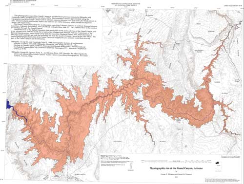
This pamphlet serves to introduce and describe the digital data. There is no paper map included in the Open-File report. The report does include, however, PostScript and PDF format plot files, each containing an image of the map.

How was the data set created?

  1. From what previous works were the data drawn?
    Billingsley and Hendricks, 1989 (source 1 of 2)
    Billingsley, George H., and Hendricks, John D., 1989, Physiographic features of northwestern Arizona: in Elston, Donald P., Billingsley, George H., and Young, Richard A., eds., Geology of Grand Canyon, Northern Arizona with Colorado River guides: 28th International Geological Congress Field Trip Guidebook T115.315, American Geophysical Union, Washington D.C..

    Other_Citation_Details: p. 67-72
    Type_of_Source_Media: paper
    Source_Contribution:
    This physiographic map of the Grand Canyon is modified from this previous version by Billingsley and Hendricks (1989)
    Billingsley et al., 1997 (source 2 of 2)
    Billingsley, George H., Spamer, Earle, E., and Menkes, Dove, 1997, Quest for the pillar of gold, the mines and miners of the Grand Canyon: Grand Canyon Association Monograph No. 10.

    Other_Citation_Details: 112 pages
    Type_of_Source_Media: paper
    Source_Contribution:
    This physiographic map of the Grand Canyon is modified from this previous version by Billingsley et al. (1997).
  2. How were the data generated, processed, and modified?
    (process 1 of 2)
    The physiograhic rim coverage contains one polygon. It was developed using elevation information contained in 100k digital line graphs (DLGs). The hypsography DLGs were downloaded from a USGS FTP (file transfer protocol) site (edcftp.cr.usgs.gov /pub/data/DLG/100K) and imported into ARC/INFO using the DLGARC command.
    Using on-screen digitizing, the edge of the Grand Canyon was estimated and drawn to form the rim coverage. Adjustments to this first draft of the rim were hand drawn onto a 200,000 scale paper plot of the rim, which included the DLG hypsography. These new lines were digitized into the existing rim coverage using an Altec AC32 digitizing tablet. This editing procedure was repeated one more time to produce the final rim coverage.
    Date: 24-Jul-2000 (process 2 of 2)
    Creation of original metadata record Person who carried out this activity:
    Jennifer Lenz
    U.S. Geological Survey
    12201 Surise Valley Drive, Mail Stop 918
    Reston, VA
    USA

    703-648-6974 (voice)
    703-648-6560 (FAX)
    pschweitzer@usgs.gov
  3. What similar or related data should the user be aware of?

How reliable are the data; what problems remain in the data set?

  1. How well have the observations been checked?
  2. How accurate are the geographic locations?
  3. How accurate are the heights or depths?
  4. Where are the gaps in the data? What is missing?
    Only contains coverages showing attributes of rivers in the area of the Grand Canyon and doesn't discuss the geology of the area.
  5. How consistent are the relationships among the observations, including topology?
    This physiographic map of the Grand Canyon is modified from previous versions by Billingsley and Hendricks (1989), and Billingsley and others (1997).

How can someone get a copy of the data set?

Are there legal restrictions on access or use of the data?
Access_Constraints: none
Use_Constraints: none
  1. Who distributes the data set? (Distributor 1 of 1)
    U.S. Geological Survey Information Services
    Box 25286, Denver Federal Center
    Denver, CO
    USA

    1-888-ASK-USGS (voice)
    1-303-202-4695 (FAX)
    infoservices@usgs.gov
  2. What's the catalog number I need to order this data set? USGS OFR 1999-30
  3. What legal disclaimers am I supposed to read?
    This report is preliminary and has not been reviewed for conformity with U.S. Geological Survey editorial standards. Any use of trade, product, or firm names is for descriptive purposes only and does not imply endorsement by the U.S. Government.
    This database, identified as "Physiographic Rim of The Grand Canyon, Arizona: A Digital Database" has been approved for release and publication by the Director of the USGS. Although this database has been reviewed and is substantially complete, the USGS reserves the right to revise the data pursuant to further analysis and review. This database is released on condition that neither the USGS nor the U. S. Government may be held liable for any damages resulting from its use.
  4. How can I download or order the data?
    • Availability in digital form:
      Data format: Contours (hypsography), boundaries, roads, rim, rivers, and towns in format ARCE (version 7.1.2) Size: 34
      Network links: http://pubs.usgs.gov/of/1999/0030/gcrim.tar.gz
    • Cost to order the data: none


Who wrote the metadata?

Dates:
Last modified: 13-Jun-2016
Metadata author:
Peter N Schweitzer
USGS Midwest Area
Collection manager, USGS Geoscience Data Clearinghouse, http://geo-nsdi.er.usgs.gov/
Mail Stop 954
12201 Sunrise Valley Dr
Reston, VA
USA

703-648-6533 (voice)
703-648-6252 (FAX)
pschweitzer@usgs.gov
Metadata standard:
FGDC Content Standards for Digital Geospatial Metadata (FGDC-STD-001-1998)

This page is <https://geo-nsdi.er.usgs.gov/metadata/open-file/99-30/metadata.faq.html>
Generated by mp version 2.9.48 on Tue Jul 03 20:07:18 2018