Map showing alpine debris flows triggered by a July 28, 1999 thunderstorm in the central Front Range of Colorado: Debris-flow polygons

Metadata also available as - [Questions & Answers] - [Parseable text] - [XML]

Metadata:

Identification_Information:
Citation:
Citation_Information:
Originator: Jonathan W. Godt
Originator: Jeffrey A. Coe
Publication_Date: 2003
Title:
Map showing alpine debris flows triggered by a July 28, 1999 thunderstorm in the central Front Range of Colorado: Debris-flow polygons
Geospatial_Data_Presentation_Form: vector digital data
Series_Information:
Series_Name: U.S. Geological Survey Open-File Report
Issue_Identification: 03-050
Publication_Information:
Publication_Place: Denver, Colorado
Publisher: U.S. Geological Survey
Online_Linkage: http://pubs.usgs.gov/of/2003/ofr-03-050/
Larger_Work_Citation:
Citation_Information:
Originator: Jonathan W. Godt
Originator: Jeffrey A. Coe
Publication_Date: 2003
Title:
Map showing alpine debris flows triggered by a July 28, 1999 thunderstorm in the central Front Range of Colorado
Edition: 1.0
Geospatial_Data_Presentation_Form: map
Series_Information:
Series_Name: U.S. Geological Survey Open-File Report
Issue_Identification: 03-050
Online_Linkage: http://pubs.usgs.gov/of/2003/ofr-03-050/
Description:
Abstract:
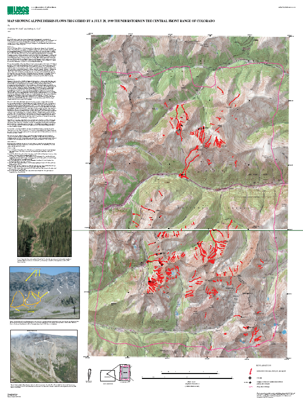
On July 28, 1999, about 480 debris flows were triggered by an afternoon thunderstorm along the Continental Divide in Clear Creek and Summit counties in the central Front Range of Colorado. This cover shows the outlines of debris-flow source areas, travel zones, and deposits. Jonathan Godt and Jeffrey Coe mapped the debris flows from 1:12,000 scale color aerial photography using a Kern PG-2 photogrammetric plotter. The photographs were scaled and oriented to the topographic base map using prominent topographic landmarks and plotted on a transparent polyester overlay registered to the topographic base maps at 1:12,000 scale. The mapped landslides were digitized manually in ArcInfo. The final scale of the data are 1:24,000.
Purpose:
The purpose of these data is provide an inventory the debris flows that were triggered over a 2-square kilometer area in the central Front Range of Colorado by a July 28, 1999 thunderstorm. These data do not consitute a debris-flow hazard map of the area.
Time_Period_of_Content:
Time_Period_Information:
Single_Date/Time:
Calendar_Date: 20000911
Currentness_Reference: ground condition
Status:
Progress: Complete
Maintenance_and_Update_Frequency: None planned
Spatial_Domain:
Bounding_Coordinates:
West_Bounding_Coordinate: -105.913431
East_Bounding_Coordinate: -105.752311
North_Bounding_Coordinate: 39.774776
South_Bounding_Coordinate: 39.586585
Keywords:
Theme:
Theme_Keyword_Thesaurus: USGS Thesaurus
Theme_Keyword: landslides
Theme_Keyword: geospatial datasets
Theme:
Theme_Keyword_Thesaurus: ISO 19115 Topic Categories
Theme_Keyword: geoscientificInformation
Place:
Place_Keyword_Thesaurus: Augmented FIPS 10-4 and FIPS 6-4
Place_Keyword: f08019 = Clear Creek
Place_Keyword: f08049 = Grand
Place_Keyword: f08117 = Summit
Access_Constraints: none
Use_Constraints:
This map is an inventory map, not hazard map, and should not be enlarged to a scale larger than 1:24,000.
Point_of_Contact:
Contact_Information:
Contact_Person_Primary:
Contact_Person: Jonathan Godt
Contact_Organization: U.S. Geological Survey
Contact_Position: Physical Scientist
Contact_Address:
Address_Type: mailing address
Address: Box 25046, MS 966
City: Denver
State_or_Province: CO
Postal_Code: 80225
Country: USA
Contact_Voice_Telephone: 303-273-8626
Contact_Facsimile_Telephone: 303-273-8600
Contact_Electronic_Mail_Address: jgodt@usgs.gov
Hours_of_Service: 8am - 4pm MST
Contact_Instructions: e-mail contact preferred
Browse_Graphic:
Browse_Graphic_File_Name: http://geo-nsdi.er.usgs.gov/metadata/open-file/03-50/browse.png
Browse_Graphic_File_Description: Reduced-size image of the map sheet, 617x822 pixels, 696k bytes
Browse_Graphic_File_Type: PNG
Native_Data_Set_Environment:
Microsoft Windows 2000 Version 5.0 (Build 2195) Service Pack 2; ESRI ArcCatalog 8.2.0.700
Data_Quality_Information:
Positional_Accuracy:
Horizontal_Positional_Accuracy:
Horizontal_Positional_Accuracy_Report:
The scale of the aerial photography allowed us to accurately identify debris-flow features as small as about 0.5 m. At 1:24,000 scale, debris-flow features less than about 5 m wide (~ 0.2 mm at 1:24,000) are not visible.
Lineage:
Process_Step:
Process_Description:
The debris-flow source areas, travel paths, and deposits were mapped using 1:12,000-scale color aerial photographs and a Kern PG-2 photogrammetric plotter. The photographs were scaled and oriented to the topographic base map using prominent topographic landmarks and plotted on a transparent polyester overlay registered to the topographic base maps at a scale of 1:12,000. The mapped debris flows were digitized manually in ArcInfo.
Process_Step:
Process_Description: Creation of original metadata record
Process_Date: 20030314
Process_Contact:
Contact_Information:
Contact_Person_Primary:
Contact_Person: Jonathan W. Godt
Contact_Organization: U.S. Geological Survey
Contact_Position: Physical Scientist
Contact_Address:
Address_Type: mailing address
Address: Box 25046, MS 966
City: Denver
State_or_Province: CO
Postal_Code: 80225
Country: USA
Contact_Voice_Telephone: 303-273-8626
Contact_Facsimile_Telephone: 303-273-8600
Contact_Electronic_Mail_Address: jgodt@usgs.gov
Hours_of_Service: 8am-4pm MST
Contact_Instructions: e-mail is preferred contact
Spatial_Data_Organization_Information:
Direct_Spatial_Reference_Method: Vector
Point_and_Vector_Object_Information:
SDTS_Terms_Description:
SDTS_Point_and_Vector_Object_Type: Complete chain
Point_and_Vector_Object_Count: 1553
SDTS_Terms_Description:
SDTS_Point_and_Vector_Object_Type: Label point
Point_and_Vector_Object_Count: 327
SDTS_Terms_Description:
SDTS_Point_and_Vector_Object_Type: GT-polygon composed of chains
Point_and_Vector_Object_Count: 329
SDTS_Terms_Description:
SDTS_Point_and_Vector_Object_Type: Point
Point_and_Vector_Object_Count: 546
Spatial_Reference_Information:
Horizontal_Coordinate_System_Definition:
Planar:
Grid_Coordinate_System:
Grid_Coordinate_System_Name: Universal Transverse Mercator
Universal_Transverse_Mercator:
UTM_Zone_Number: 13
Transverse_Mercator:
Scale_Factor_at_Central_Meridian: 0.9996
Longitude_of_Central_Meridian: -105.0
Latitude_of_Projection_Origin: 0.0
False_Easting: 500000.0
False_Northing: 0.0
Planar_Coordinate_Information:
Planar_Coordinate_Encoding_Method: coordinate pair
Coordinate_Representation:
Abscissa_Resolution: 0.000011
Ordinate_Resolution: 0.000011
Planar_Distance_Units: meters
Geodetic_Model:
Horizontal_Datum_Name: North American Datum of 1927
Ellipsoid_Name: Clarke 1866
Semi-major_Axis: 6378206.400000
Denominator_of_Flattening_Ratio: 294.978698
Entity_and_Attribute_Information:
Detailed_Description:
Entity_Type:
Entity_Type_Label: fr-dfcl2.aat
Entity_Type_Definition: boundary line
Attribute:
Attribute_Label: BOUND
Attribute_Definition: indicates whether the arc encloses the study area boundary
Attribute_Domain_Values:
Enumerated_Domain:
Enumerated_Domain_Value: stdy
Enumerated_Domain_Value_Definition: study area boundary
Attribute_Domain_Values:
Enumerated_Domain:
Enumerated_Domain_Value: null
Enumerated_Domain_Value_Definition: not study area boundary
Detailed_Description:
Entity_Type:
Entity_Type_Label: fr-dfcl2.pat
Entity_Type_Definition: debris flow or othe polygonal area of interest
Attribute:
Attribute_Label: SURFACE
Attribute_Definition: indicates feature type
Attribute_Domain_Values:
Enumerated_Domain:
Enumerated_Domain_Value: df
Enumerated_Domain_Value_Definition: debris flow
Attribute_Domain_Values:
Enumerated_Domain:
Enumerated_Domain_Value: cd
Enumerated_Domain_Value_Definition: channel deposit - not shown on map
Attribute_Domain_Values:
Enumerated_Domain:
Enumerated_Domain_Value: stdy
Enumerated_Domain_Value_Definition: study area polygon
Distribution_Information:
Distributor:
Contact_Information:
Contact_Organization_Primary:
Contact_Organization: USGS Information Services
Contact_Address:
Address_Type: mailing address
Address: Box 25286 Denver Federal Center
City: Denver
State_or_Province: CO
Postal_Code: 80225
Country: USA
Contact_Voice_Telephone: 1-888-ASK-USGS
Contact_Facsimile_Telephone: 303-202-4693
Contact_Electronic_Mail_Address: ask@usgs.gov
Resource_Description: USGS Open-File Report 03-50
Distribution_Liability:
This report is preliminary and has not been reviewed for conformity with U.S. Geological Survey editorial standards or with the North American Stratigraphic Code. Any use of trade, firm, or product names is for descriptive purposes only and does not imply endorsement by the U.S. Government.
Standard_Order_Process:
Digital_Form:
Digital_Transfer_Information:
Format_Name: ARCE
Format_Version_Number: 8.x
Format_Information_Content: Debris-flow polygons
Transfer_Size: 1.8
Digital_Transfer_Option:
Online_Option:
Computer_Contact_Information:
Network_Address:
Fees: none
Metadata_Reference_Information:
Metadata_Date: 20160613
Metadata_Contact:
Contact_Information:
Contact_Person_Primary:
Contact_Person: Peter N Schweitzer
Contact_Organization: USGS Midwest Area
Contact_Position:
Collection manager, USGS Geoscience Data Clearinghouse, http://geo-nsdi.er.usgs.gov/
Contact_Address:
Address_Type: mailing address
Address:
Mail Stop 954
12201 Sunrise Valley Dr
City: Reston
State_or_Province: VA
Postal_Code: 20192-0002
Country: USA
Contact_Voice_Telephone: 703-648-6533
Contact_Facsimile_Telephone: 703-648-6252
Contact_Electronic_Mail_Address: pschweitzer@usgs.gov
Metadata_Standard_Name: Content Standard for Digital Geospatial Metadata
Metadata_Standard_Version: FGDC-STD-001-1998
Metadata_Access_Constraints: none
Metadata_Use_Constraints: none

This page is <https://geo-nsdi.er.usgs.gov/metadata/open-file/03-50/flows.html>
Generated by mp version 2.9.48 on Tue Jul 03 20:06:21 2018