Citation:
Citation_Information:
Originator: Scott Southworth
Originator: David K. Brezinski
Originator: Avery Ala Drake, Jr.
Originator: William C. Burton
Originator: Randall C. Orndorff
Originator: Albert J. Froelich
Originator: David L. Daniels
Originator: James E. Reddy
Originator: Danielle Denenny
Publication_Date: 2002
Title:
Digital geologic map and database of the Frederick 30 X 60 minute quadrangle, Maryland, Virginia, and West Virginia
Edition: 1.0
Geospatial_Data_Presentation_Form: Vector digital data and map
Series_Information:
Series_Name: U.S. Geological Survey Open-File Report
Issue_Identification: 02-437
Publication_Information:
Publication_Place: Reston, Virginia
Publisher: U.S. Geological Survey
Online_Linkage: http://pubs.usgs.gov/of/2002/of02-437/
Description:
Abstract:
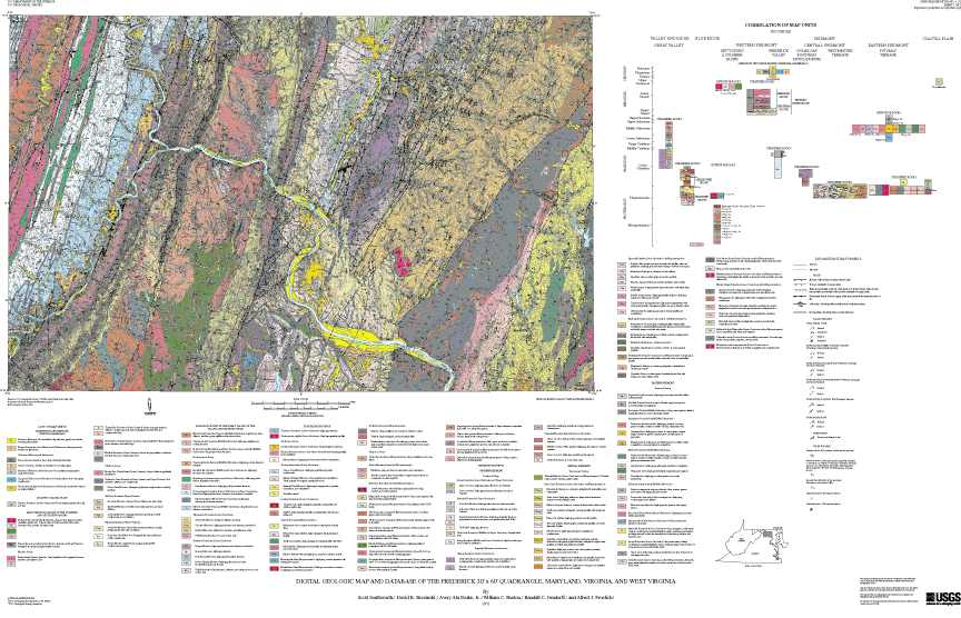
The geology of the Frederick 30 by 60 minute quadrangle, Maryland, Virginia, and West Virginia, was mapped on 1:24,000-scale base maps from 1989 to 1994. The geologic data were manually compiled at 1:100,000-scale in 1997 and were digitized and converted to Arc/Info GIS coverages from 1998 to 1999.
Purpose:
The geologic map and database are intended for application to land use decisions, soil mapping, groundwater availability and quality, aggregate resources, and engineering and environmental studies. For site specific studies, the detailed 1:24,000-scale geologic maps should be consulted.
Supplemental_Information:
Geologic data are stored in eleven GIS themes: A-A' and B-B' cross sections, bedrock, dikes, faults, lakebeds, thermally metamorphosed rocks, map neat line, sinkholes, structural, and surficial. Base data are stored in five GIS themes: hydrology, land cover, political boundaries, roads, and elevation contours.
Data_Set_Structure:
Data_Set_Part:
Part_Type: Arc/Info coverages, INFO tables, and their export-interchange file equivalents (files with *.e00 extensions)
Part_Name: Geologic map data
Part_Description: These coverages and INFO tables provide the scientific content of the mapped data
Data_Set_Part:
Part_Type: Arc/Info coverage
Part_Name: ASECTION
Part_Description: Line and polygon data for the A-A' cross section
Data_Set_Part:
Part_Type: Arc/Info coverage
Part_Name: BEDROCK
Part_Description: Polygon data layer of bedrock geologic map units
Data_Set_Part:
Part_Type: Arc/Info coverage
Part_Name: BSECTION
Part_Description: Line and polygon data for the B-B' cross section
Data_Set_Part:
Part_Type: Arc/Info coverage
Part_Name: FAULT
Part_Description: Line data layer of geologic faults
Data_Set_Part:
Part_Type: Arc/Info coverage
Part_Name: LAKEBED
Part_Description: Line data layer of lakebed locations
Data_Set_Part:
Part_Type: Arc/Info coverage
Part_Name: LINES
Part_Description: Line data layer of geologic cross sections
Data_Set_Part:
Part_Type: Arc/Info coverage
Part_Name: META
Part_Description: Polygon data layer of thermally metamorphosed rocks
Data_Set_Part:
Part_Type: Arc/Info coverage
Part_Name: NEAT
Part_Description: Polygon data layer of map neatline
Data_Set_Part:
Part_Type: Arc/Info coverage
Part_Name: SINK
Part_Description: Point data layer of sinkhole locations
Data_Set_Part:
Part_Type: Arc/Info coverage
Part_Name: STRUCTURE
Part_Description: Point data layer of geologic structure
Data_Set_Part:
Part_Type: Arc/Info coverage
Part_Name: SURFICIAL
Part_Description: Polygon data layer of surficial geologic map units
Data_Set_Part:
Part_Type: Arc/Info coverage
Part_Name: ZMD_DIKE
Part_Description: Line and polygon data layer of Zmd dikes
Data_Set_Part:
Part_Type: Info table
Part_Name: 02437
Part_Description: Geologic database (Info equivalent of Microsoft Access database 02437.mdb)
Data_Set_Part:
Part_Type: Arc/Info coverages, grid, INFO tables, and their export-interchange file equivalents (files with *.e00 extensions)
Part_Name: Base map data
Part_Description: These coverages and INFO tables provide the base map to which the geologic information is geographically registered
Data_Set_Part:
Part_Type: Arc/Info coverage
Part_Name: HYDRO
Part_Description: Line and polygon data layer of hydrographic features
Data_Set_Part:
Part_Type: Arc/Info grid
Part_Name: NLCD
Part_Description: Raster land cover data
Data_Set_Part:
Part_Type: Arc/Info coverage
Part_Name: POLBND
Part_Description: Line and polygon data layer of state and county boundaries
Data_Set_Part:
Part_Type: Arc/Info coverage
Part_Name: ROADS
Part_Description: Line data layer of major highways
Data_Set_Part:
Part_Type: Arc/Info coverage
Part_Name: TOPO
Part_Description: Line data layer of elevation contours
Data_Set_Part:
Part_Type: Spatial Data Transfer Standard (SDTS) data exchange files
Part_Name: Geologic map data
Part_Description: These SDTS files provide the scientific content of the mapped data
Data_Set_Part:
Part_Type: SDTS files
Part_Name: ASEC*.*
Part_Description: SDTS files for the A-A' cross section
Data_Set_Part:
Part_Type: SDTS files
Part_Name: BEDR*.*
Part_Description: SDTS files for the bedrock geologic map units
Data_Set_Part:
Part_Type: SDTS files
Part_Name: BSEC*.*
Part_Description: SDTS files for the B-B' cross section
Data_Set_Part:
Part_Type: SDTS files
Part_Name: FAUL*.*
Part_Description: SDTS files for the geologic faults
Data_Set_Part:
Part_Type: SDTS files
Part_Name: LAKE*.*
Part_Description: SDTS files for the lakebed locations
Data_Set_Part:
Part_Type: SDTS files
Part_Name: LINE*.*
Part_Description: SDTS files for the geologic cross sections
Data_Set_Part:
Part_Type: SDTS files
Part_Name: META.*
Part_Description: SDTS files for the thermally metamorphosed rocks
Data_Set_Part:
Part_Type: SDTS files
Part_Name: NEAT.*
Part_Description: SDTS files for the map neatline
Data_Set_Part:
Part_Type: SDTS files
Part_Name: SINK.*
Part_Description: SDTS files for the sinkhole locations
Data_Set_Part:
Part_Type: SDTS files
Part_Name: STRU*.*
Part_Description: SDTS files for the geologic structure
Data_Set_Part:
Part_Type: SDTS files
Part_Name: SURF*.*
Part_Description: SDTS files for the surficial geologic map units
Data_Set_Part:
Part_Type: SDTS files
Part_Name: DIKE*.*
Part_Description: SDTS files for the Zmd dikes
Data_Set_Part:
Part_Type: Spatial Data Transfer Standard (SDTS) data exchange files
Part_Name: Base map data
Part_Description: These SDTS files provide the base map to which the geologic information is geographically registered
Data_Set_Part:
Part_Type: SDTS files
Part_Name: HYDR*.*
Part_Description: SDTS files for the hydrographic features
Data_Set_Part:
Part_Type: SDTS files
Part_Name: NLCD*.*
Part_Description: SDTS files for the land cover data
Data_Set_Part:
Part_Type: SDTS files
Part_Name: POLB*.*
Part_Description: SDTS files for the state and county boundaries
Data_Set_Part:
Part_Type: SDTS files
Part_Name: ROAD*.*
Part_Description: SDTS files for the major highways
Data_Set_Part:
Part_Type: SDTS files
Part_Name: TOPO*.*
Part_Description: SDTS files for the elevation contours
Data_Set_Part:
Part_Type: Microsoft Access database and its dBASE and ASCII text file equivalents
Part_Name: Geologic database
Part_Description: This database contains attribute information that can be used as supplements to the GIS layers
Data_Set_Part:
Part_Type: Microsoft Access database
Part_Name: 02437.MDB
Part_Description: Database designed by the Eastern Region's Earth Surface Processes Team (EESPT) of the U.S. Geological Survey
Time_Period_of_Content:
Time_Period_Information:
Range_of_Dates/Times:
Beginning_Date: 1997
Ending_Date: 2002
Currentness_Reference: Publication date
Status:
Progress: Complete
Maintenance_and_Update_Frequency: None planned
Spatial_Domain:
Bounding_Coordinates:
West_Bounding_Coordinate: -78.00
East_Bounding_Coordinate: -77.00
North_Bounding_Coordinate: 39.50
South_Bounding_Coordinate: 39.00
Keywords:
Theme:
Theme_Keyword_Thesaurus: USGS Thesaurus
Theme_Keyword: geology
Theme_Keyword: geologic maps
Theme_Keyword: bedrock geologic units
Theme_Keyword: surficial geologic units
Theme_Keyword: faulting (geologic)
Theme_Keyword: geologic structure
Theme_Keyword: geospatial datasets
Theme:
Theme_Keyword_Thesaurus: none
Theme_Keyword: Geology
Theme_Keyword: Geologic
Theme_Keyword: Bedrock
Theme_Keyword: Surficial
Theme_Keyword: Fault
Theme_Keyword: Structure
Theme_Keyword: Dike
Theme_Keyword: Lakebed
Theme_Keyword: Sinkhole
Theme_Keyword: Map
Theme:
Theme_Keyword_Thesaurus: ISO 19115 Topic Categories
Theme_Keyword: geoscientificInformation
Place:
Place_Keyword_Thesaurus: none
Place_Keyword: Frederick
Place_Keyword: Maryland
Place_Keyword: Virginia
Place_Keyword: West Virginia
Place:
Place_Keyword_Thesaurus: Augmented FIPS 10-4 and FIPS 6-4
Place_Keyword: f51107 = Loudoun
Place_Keyword: f54037 = Jefferson
Place_Keyword: f24021 = Frederick
Place_Keyword: f24031 = Montgomery
Place_Keyword: f24013 = Carroll
Place_Keyword: f24027 = Howard
Place_Keyword: f24043 = Washington
Place_Keyword: f51059 = Fairfax
Place_Keyword: f51061 = Fauquier
Place_Keyword: f54003 = Berkeley
Access_Constraints: None
Use_Constraints:
Although all data released in this report have been used by the USGS, no warranty, expressed or implied, is made by the USGS as to the accuracy of the data and related materials and (or) the functioning of the software. Any use of trade, product, or firm names is for descriptive purposes only and does not imply endorsement by the U.S. Government.
Point_of_Contact:
Contact_Information:
Contact_Person_Primary:
Contact_Person: Scott Southworth
Contact_Organization: U.S. Geological Survey
Contact_Address:
Address_Type: Mailing address
Address: National Center, MS926A
City: Reston
State_or_Province: Virginia
Postal_Code: 20192
Country: USA
Contact_Voice_Telephone: 703-648-6385
Contact_Facsimile_Telephone: 703-648-6953
Contact_Electronic_Mail_Address: [email protected]
Browse_Graphic:
Browse_Graphic: