Online Links:
The following is a brief description of the data layers, tables, and their associated attributes that are used in this report.
GEOLOGIC DATA:
ASECTION - Line and polygon data for the A-A' cross section
ASECTION.AAT items:
PLOTCODE - Used for plotting
TYPE - Used to identify faults
ASECTION.PAT items:
PLOTCODE - Used for plotting
MAPUNIT - Geologic map unit code
BEDROCK - Polygon data layer of bedrock geologic map units
BEDROCK.PAT items:
MAPUNIT - Bedrock geologic map unit code
BSECTION - Line and polygon data for the B-B' cross section
BSECTION.AAT items:
PLOTCODE - Used for plotting
TYPE - Used to identify faults
BSECTION.PAT items:
PLOTCODE - Used for plotting
MAPUNIT - Geologic map unit code
META - Used to identify thermally metamorphosed rocks. Set to 'JTrtm'.
FAULT - Line data layer of geologic faults
FAULT.AAT items:
TYPE - Type of fault
TYPE Code Description
N Normal
T Thrust
NT Normal reactivated as thrust
OT Overturned thrust
SS Strike-slip
ARO Arrow showing movement along strike-slip fault
U Unclassified
CODE - Identifies fault segments which are overlaid by surficial deposits
(CODE = 2). Used for plotting.
LAKEBED - Line data layer of lakebed locations
LAKEBED.AAT items:
TYPE - Set to 'Lakebed'
LINES - Line data layer of geologic cross sections
LINES.AAT items:
XLINE - Identifies cross section, set to "A-A'" or "B-B'"
META - Polygon data layer of thermally metamorphosed rocks
META.PAT items:
MAPUNIT - Geologic map unit code. Set to 'JTrtm'.
NEAT - Unattributed line data layer of map neatline
SINK - Point data layer of sinkhole locations
SINK.PAT items:
MAPUNIT - Set to 'Sinkhole'
STRUCTURE - Point data layer of geologic structure
STRUCTURE.PAT items:
DIP - Dip value (planar data) or plunge value (linear data)
AZIMUTH - Angle measured from North in right-hand rule (planar data).
TYPE - Type of geologic structure
TYPE Code Description
AGE Sample site for U-Pb isotopic technique for age date
HB Horizontal bed
I1C Inclined first-generation Paleozoic cleavage and (or) schistosity
I2C Inclined second-generation Paleozoic cleavage and (or) schistosity
IB Inclined bed
IF Inclined Middle Proterozoic foliation
MA Minor antiform
MPF Inclined mylonitic and phyllonitic foliations
OB Overturned bed
QM Quarry or mine
RAD Greater than 200 pCi/L of soil gas radon
V1C Vertical first-generation Paleozoic cleavage and (or) schistosity
V2C Vertical second-generation Paleozoic cleavage and (or) schistosity
VB Vertical bed
VF Vertical Middle Proterozoic foliation
SUB_TYPE - Type of quarry mine
SUB_TYPE
Code Description
Au Gold
C Chromite
Cu Copper
D Diabase
F Hematite, limonite, and iron-ore
L Limestone
M Marble
S Building stone
Zn Zinc
SYMBOL_ANG - Standard Cartesian angle measured from East. Used for plotting.
DIPDIR - Direction of dip (planar data) or trend (linear data) measured from North
SYMBOL - Symbol number, used for plotting
SURFICIAL - Polygon data layer of surficial geologic map units
SURFICIAL.PAT items:
MAPUNIT - Surficial geologic map unit code
ZMD_DIKE - Line and polygon data layer of Zmd dikes
ZMD_DIKE.AAT items:
TYPE - Set to 'Zmd'
ZMD_DIKE.PAT items:
MAPUNIT - Set to 'Zmd'
02437 - Geologic database
If you are using Arc/Info Workstation you can access the data in this table using either the
JOINITEM, RELATE, or CURSOR functions and the INFO item MAPUNIT. Use the RELATE function to
access this data from ArcMap. If you are using ArcView, add the table 02437.DBF to the
project and use either the JOIN or LINK functions and the item MAPUNIT to access the data.
Alternatively, the database 02437.MDB can be viewed using Microsoft Access.
02437 items:
MAPUNIT - Geologic map unit code
SURF_BED
SURFTYPE
LITHPRI
LITHSEC
LITHTER
FORM
MEMBER
GROUP
SUPERGROUP
ROCKCLASS
AGE
GEOCHR
GEOCHRTECH
GEOCHRREF
FOSSIL
FOSSILTYPE
FOSSILREF
CORRELEXTR
ORIGIN
RES
RESREF
COLOR
MINPRI
MINSEC
MINOTH
CLASTPRI
CLASTSEC
CEMENT
THICKAPPRX
THICKRANGE
BEDTHIN
BEDMEDIUM
BEDTHICK
CONTUP
CONTLOW
FOLPRI
FOLSEC
FOLTER
CMPM
RMPM
RMRM
DEFORMAGE
DEFORMTECH
DEFORMREF
COMMENTS
BASE DATA:
HYDRO - Line and polygon data layer of hydrographic features
HYDRO.AAT items:
ENTITY_LABEL - DLG code
ENTITY_DEF - Short definition of the DLG code contained in ENTITY_LABEL
BANK - Defines the right (R) and left (L) limits of a double-line feature when facing downstream
INTERMITTENT - Defines any hydrographic feature which flows intermittently
COINCIDENT - Identifies lines shared by two or more hydrographic features
HYDRO.PAT items:
ENTITY_LABEL - DLG code
ENTITY_DEF - Short definition of the DLG code contained in ENTITY_LABEL
ELEVATION - Water surface elevation, whole meters
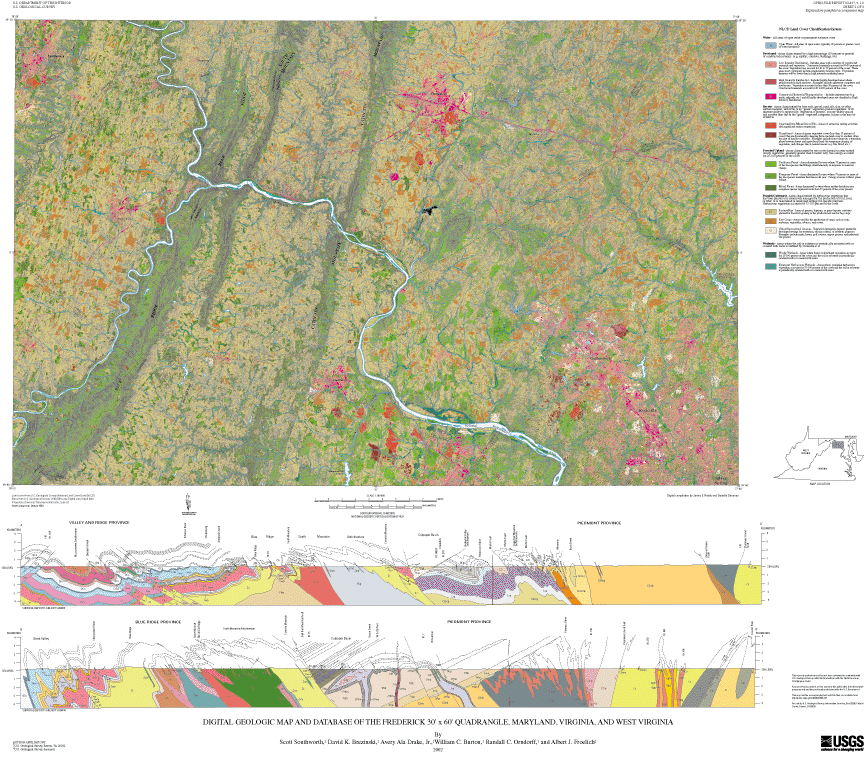
NLCD - Raster land cover data set
NLCD.VAT items:
VALUE - Land cover code
VALUE Code Description
11 Open water
21 Low intensity residential
22 High intensity residential
23 Commercial/Industrial/Transportation
32 Quarries/Strip mines/Gravel pits
33 Transitional
41 Deciduous forest
42 Evergreen forest
43 Mixed forest
81 Pasture/Hay
82 Row crops
85 Urban/Recreational grasses
91 Woody wetlands
92 Emergent herbaceous wetlands
COUNT - Total number of cells belonging to each value code
SYMBOL - Symbol number, used for plotting
POLBND - Line and polygon data layer of state and county boundaries:
POLBND.AAT items:
POLBND-ID
TYPE - State or county boundary
POLBND.PAT items:
STATE_NAME - State in which county resides
CNTY_NAME - County name
STATE_FIPS - State FIPS code (character field)
CNTY_FIPS - County FIPS code (character field)
FIPS - FIPS code for state/county (character field)
MAJOR# - DLG code
MINOR# - DLG code
Major DLG Minor DLG
Code Code Description
91 --- State FIPS code (integer field)
92 --- County FIPS code (integer field)
ROADS - Line data layer of major highways
ROADS.AAT items:
MAJOR# - DLG code
MINOR# - DLG code
Major DLG Minor DLG
Code Code Description
170 201 Primary route, class 1, undivided
170 203 Primary route, class 1, divided
170 205 Secondary route, class 2, undivided
170 207 Secondary route, class 2, divided
170 209 Road or street, class 3
170 402 Cloverleaf or interchange
172 --- Interstate route number
173 --- U.S. route number
174 --- State route number
TOPO - Line data layer of elevation contours
TOPO.AAT items:
MAJOR# - DLG code
MINOR# - DLG code
Major DLG Minor DLG
Code Code Description
20 20O Contour (index or intermediate)
20 201 Carrying contour
20 204 Amended contour
20 208 Closure line
20 611 Depression
24 --- Elevation in whole meters
TYPE - Type of contour: index (Index) or intermediate (Inter),
used for plotting
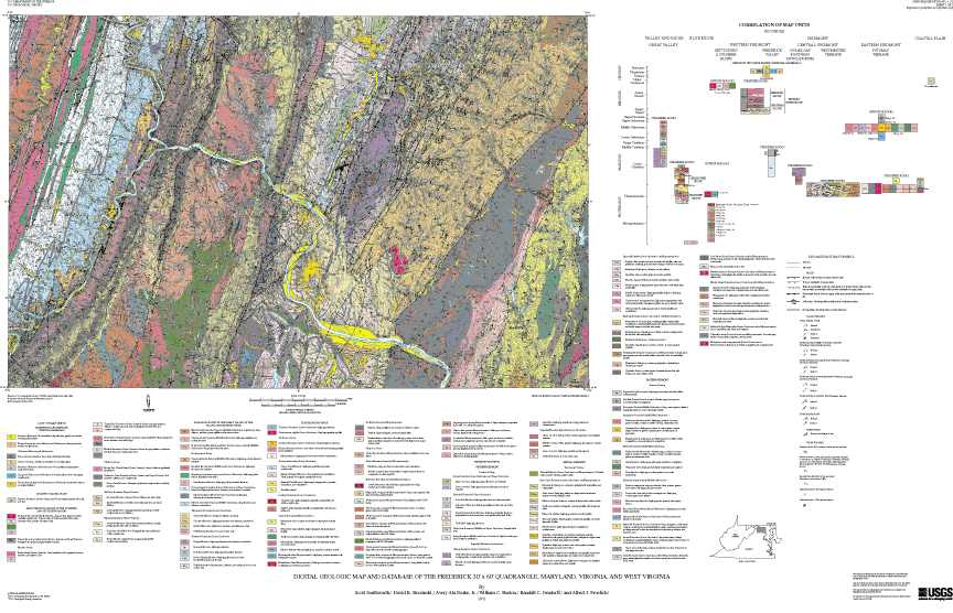
The geologic map and database are intended for application to land use decisions, soil mapping, groundwater availability and quality, aggregate resources, and engineering and environmental studies. For site specific studies, the detailed 1:24,000-scale geologic maps should be consulted.
Are there legal restrictions on access or use of the data?Access_Constraints: None
Use_Constraints:Although all data released in this report have been used by the USGS, no warranty, expressed or implied, is made by the USGS as to the accuracy of the data and related materials and (or) the functioning of the software. Any use of trade, product, or firm names is for descriptive purposes only and does not imply endorsement by the U.S. Government.
These data were prepared by an agency of the United States Government. Neither the United States Government nor any agency thereof, nor any of their employees, make any warranty, expressed or implied, or assume any legal liability or responsibility for the accuracy, completeness, or usefulness of any information, apparatus, product or process disclosed in this report, and represents that its use would not infringe privately owned rights. The act of distribution shall not constitute any such warranty, and no responsibility is assumed by the USGS in the use of this data or related materials. Reference therein to any specific commercial product, process, or related service by trade name, trademark, manufacturer, or otherwise does not necessarily constitute or imply its endorsement, recommendation, or favoring by the United States Government or any agency thereof.
| Data format: | Bedrock and surficial geologic map units, geologic cross sections, faults, structural geology, political boundaries, elevation contours, hydrology and major highways. in format ARCE (version 8.1.2) Size: 35 |
|---|---|
| Network links: |
http://pubs.usgs.gov/of/2002/of02-437/data/of02437_gz.tar.gz |