Online Links:
The following is a brief description of the data layers, tables, and their associated
attributes that are used in this report.
GEOLOGIC DATA:
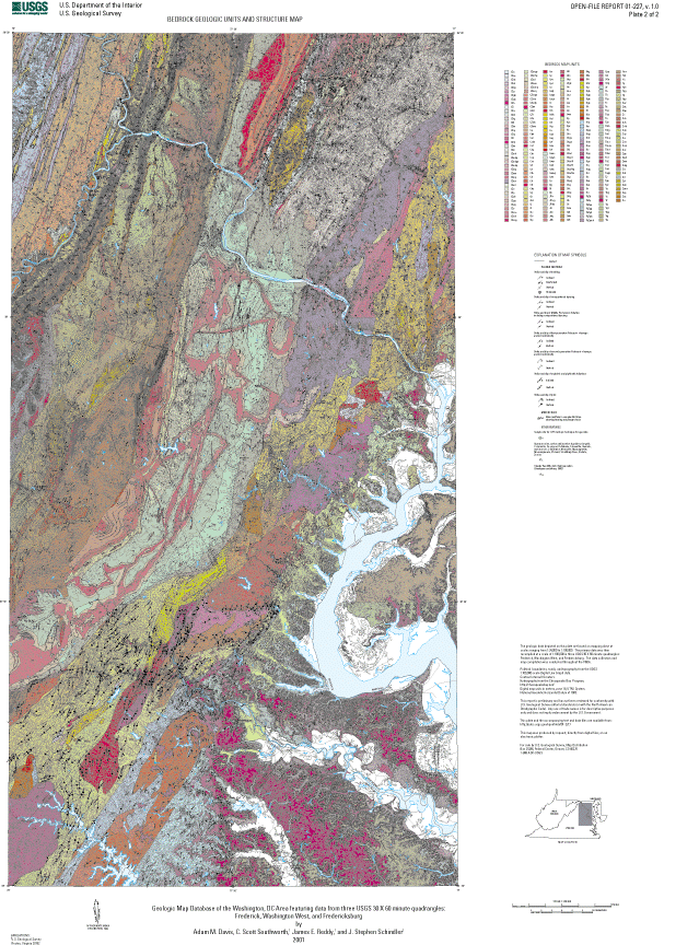
BEDROCK - Polygon data layer of bedrock geologic map units
BEDROCK.PAT items:
MAPUNIT - Bedrock geologic map unit code
COA_ID - Compound object archive identifier, map unit names and descriptions -
a data linkage hub in North American Data Model (NADM) 4.3
FAULT - Line data layer of geologic faults and folds
FAULT.AAT items:
SYMBOL - Symbol number from FAULT.LIN or ALCNEW61.LIN linesets, used for plotting
SYMBOL-ARC - Symbol number from GDS1.LIN lineset, used for plotting
FEATURE - Geologic Data Systems (GDS) assigned feature description
ELEVATION - GDS assigned attribute
TYPE - Type of fault
TYPE Code Description
AC Anticline
AF Antiform
ARO Arrow showing movement along strike-slip fault
FZ Fault zone
N Normal fault
NT Normal fault re-activated as thrust fault
OT Overturned thrust fault
SC Syncline
SF Synform
SS Strike-slip fault
T Thrust fault
TA Thermal aureole
UF Unclassified fault
ULF Unclassified linear feature
CODE - Identifies fault segments which are overlaid by surficial deposits
(CODE = 2). Used for plotting. Relevant only for those faults which
lie within the boundary of the USGS Frederick 1:100000-scale map.
QUAD - Identifies the USGS 1:100000-scale map to which the feature belongs
QUAD
Code Description
FB - Fredericksburg
FK - Frederick
WW - Washington West
NEAT - Line data layer of map neatline
SINK - Point data layer of sinkhole locations
SINK.PAT items:
MAPUNIT - Set to 'Sinkhole'
STRUCTURE - Point data layer of geologic structure
STRUCTURE.PAT items:
DIP - Dip value (planar data) or plunge value (linear data)
STRIKE_ANG - GDS assigned angle measured from North
AZIMUTH - Angle measured from North in right-hand rule (planar data).
Routines used to digitize the geologic structure symbols that
lie within the boundaries of the USGS Frederick and Washington
West 1:100000-scale maps (item QUAD equal to 'FK' and 'WW',
respectively) resulted in the azimuth value for those symbols to
be calculated based on a northern trend (270<=azimuth<=90).
Southern trending azimuth values (90<azimuth<270) for structure
symbols associated with the Frederick and Washington West maps
were translated to their northern trend equivalents. If necessary,
the southern trending azimuth values for these symbols can be
restored using the item SYMB_ANG and the following equations:
For 180<SYMB_ANG<=270,
azimuth = AZIMUTH + 180
For 270<SYMB_ANG<360,
azimuth = AZIMUTH - 180
TYPE - Type of geologic structure. Relevant for geologic structure data
that lies within the boundaries of the USGS Frederick and Washington West
1:100000-scale maps (item QUAD equal to 'FK' and 'WW')
TYPE Code Description
AGE Sample site for U-Pb isotopic technique for age date
HB Horizontal bed
I1C Inclined first-generation Paleozoic cleavage and (or) schistosity
I2C Inclined second-generation Paleozoic cleavage and (or) schistosity
IEF Inclined early foliation
IB Inclined bed
IF Inclined Middle Proterozoic foliation
IMP Inclined mylonitic and phyllonitic foliations
IPF Inclined phyllonitic foliation
MA Minor antiform
OB Overturned bed
QM Quarry or mine
RAD Greater than 200 pCi/L of soil gas radon
V1C Vertical first-generation Paleozoic cleavage and (or) schistosity
V2C Vertical second-generation Paleozoic cleavage and (or) schistosity
VB Vertical bed
VEF Vertical early foliation
VF Vertical Middle Proterozoic foliation
VMP Vertical mylonitic and phyllonitic foliations
SUB_TYPE - Type of quarry mine
SUB_TYPE
Code Description
Ag Silver
Au Gold
C Chromite
Cu Copper
D Diabase
F Hematite, limonite, and iron-ore
L Limestone
M Marble
Mg Magnetite
Mn Manganese
Pb Lead
S Building stone
Sl Slate
Zn Zinc
SYMB_ANG - Standard Cartesian angle measured from East. Used for plotting.
DIPDIR - Direction of dip (planar data) or trend (linear data) measured from North
SYMBOL - Symbol number from the LOUDOUN_AP.MRK markerset or the MPLY.LIN lineset,
used for plotting
FEATURE - Type of geologic structure. Relevant for geologic structure data that
lies within the boundary of the USGS Fredericksburg 1:100000-scale
map (item QUAD equal to 'FB')
GROUP - GDS assigned attribute
METHOD - GDS assigned attribute
SOURCE - GDS assigned attribute
DIP_DIR - GDS assigned attribute
SYMB_ARC - Symbol number from the GDS1.MRK markerset, used for plotting
QUAD - Identifies the USGS 1:100000-scale map to which the structure data belongs
QUAD
Code Description
FB - Fredericksburg
FK - Frederick
WW - Washington West
SURFICIAL - - Polygon data layer of surficial geologic map units
SURFICIAL.PAT items:
MAPUNIT - Surficial geologic map unit code
COA_ID - Compound object archive identifier, map unit names and descriptions -
a data linkage hub in North American Data Model (NADM) 4.3
BASE DATA:
POLBND - Net data layer of state and county boundaries:
POLBND.AAT items:
POLBND-ID
TYPE - State or county boundary
POLBND.PAT items:
STATE_NAME - State in which county resides
CNTY_NAME - County name
STATE_FIPS - State FIPS code (character field)
CNTY_FIPS - County FIPS code (character field)
FIPS - FIPS code for state/county (character field)
MAJOR# - DLG code
MINOR# - DLG code
Major DLG Minor DLG
Code Code Description
91 --- State FIPS code (integer field)
92 --- County FIPS code (integer field)
ROADS - Line data layer of major highways
ROADS.AAT items:
MAJOR# - DLG code
MINOR# - DLG code
Major DLG Minor DLG
Code Code Description
170 201 Primary route, class 1, undivided
170 203 Primary route, class 1, divided
170 204 Primary route, class 1, one way
170 205 Secondary route, class 2, undivided
170 207 Secondary route, class 2, divided
170 209 Road or street, class 3
170 210 Road or street, class 4
170 401 Traffic circle
170 402 Cloverleaf or interchange
170 607 Underpassing
170 617 Business route
172 --- Interstate route number
173 --- U.S. route number
174 --- State route number
TOPO - Line data layer of elevation contours
TOPO.AAT items:
MAJOR# - DLG code
MINOR# - DLG code
Major DLG Minor DLG
Code Code Description
20 20O Contour (index or intermediate)
20 201 Carrying contour
20 204 Amended contour
20 208 Closure line
20 611 Depression
24 --- Elevation in whole meters
TYPE - Type of contour: index (Index) or intermediate (Inter),
used for plotting
HYDRO - Polygon data layer of major water bodies
HYDRO.PAT items:
RINGS_OK - Attribute assigned by the Chesapeake Bay Program
RINGS_NOK - Attribute assigned by the Chesapeake Bay Program
FEATURE - Type of hydrologic feature (stream, pond, marsh, etc.)
Geology was researched and compiled for use in studies of ecosystem health, environmental impact, soils, groundwater, land use, tectonics, crustal genesis, sedimentary provenance, and any others that could benefit from geographically referenced geological data.
Are there legal restrictions on access or use of the data?Access_Constraints: None
Use_Constraints:Although all data released in this report have been used by the USGS, no warranty, expressed or implied, is made by the USGS as to the accuracy of the data and related materials and (or) the functioning of the software. Any use of trade, product, or firm names is for descriptive purposes only and does not imply endorsement by the U.S. Government.
These data were prepared by an agency of the United States Government. Neither the United States Government nor any agency thereof, nor any of their employees, make any warranty, expressed or implied, or assume any legal liability or responsibility for the accuracy, completeness, or usefulness of any information, apparatus, product or process disclosed in this report, and represents that its use would not infringe privately owned rights. The act of distribution shall not constitute any such warranty, and no responsibility is assumed by the USGS in the use of this data or related materials. Reference therein to any specific commercial product, process, or related service by trade name, trademark, manufacturer, or otherwise does not necessarily constitute or imply its endorsement, recommendation, or favoring by the United States Government or any agency thereof.
| Data format: | Bedrock and surficial geologic map units, fault and fold axes, structural geology, political boundaries, elevation contours, and major highways and water bodies. in format ARCE (version 8.0.2) Size: 37.0 |
|---|---|
| Network links: |
http://pubs.usgs.gov/of/2001/of01-227/of01227.zip |