Citation:
Citation_Information:
Originator: A.S. Jayko
Originator: R.E. Wells
Publication_Date: 2001
Title:
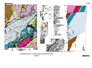
Reconnaissance Geologic Map of the Dixonville 7.5' Quadrangle, Oregon
Edition: 1.0
Geospatial_Data_Presentation_Form: vector digital data
Series_Information:
Series_Name: U.S. Geological Survey Open-File Report
Issue_Identification: Open File Report 01-226
Publication_Information:
Publication_Place: Menlo Park, CA
Publisher: U.S. Geological Survey
Online_Linkage: http://pubs.usgs.gov/of/2001/0226/
Description:
Abstract:
This digital map database, compiled from new mapping by the authors, represents the general distribution of bedrock and surficial deposits of the Dixonville 7.5 minute quadrangle along the southeastern margin of the Oregon Coast Range and its tectonic boundary with Mesozoic terranes of the Klamath Mountains. Together with the accompanying text files as PDF (geol.pdf), it provides current information on the geologic structure and stratigraphy of the area covered. The database delineates map units that are identified by general age and lithology following the stratigraphic nomenclature of the U.S. Geological Survey. The scale of the source maps is 1:24,000. The spatial resolution (scale) of the database is 1:24,000 or smaller.
Purpose:
This study was undertaken as part of a contribution to 1:100,000 mapping of the Roseburg 30' x 60' quadrangle (Wells, et al., 2000). The purpose of this mapping was to assess the oil and gas potential of the Tertiary Tyee basin (see Ryu, et al., 1996). This database and accompanying plot file depict the distribution of geologic materials and structures at a large (1:24,000) scale. The report is intended to provide geologic information for the study of material properties, mineral resources, and geologic hazards. In addition, the report contains new information and interpretations about the regional geologic history and framework. However, the scale of this report does not provide sufficient detail for site development purposes. For example, landslides in the database are generalized and many smaller slope failures are not shown.
Supplemental_Information:
Procedures_Used: The databases in this report were compiled in ARC/INFO, a commercial Geographic Information System (Environmental Systems Research Institute, Redlands, California, with version 3.0 of the menu interface ALACARTE (Fitzgibbon and Wentworth, 1991, Fitzgibbon, 1991, Wentworth and Fitzgibbon, 1991). The files are in either GRID (ARC/INFO raster data) format or COVERAGE (ARC/INFO vector data) format. Coverages are stored in uncompressed ARC export format (ARC/INFO version 8.0.2). ARC/INFO export files (files with the .e00 extension) can be converted into ARC/INFO coverages in ARC/INFO (see below) and can be read by some other Geographic Information Systems, such as MapInfo via ArcLink and ESRI's ArcView (version 1.0 for Windows 3.1 to 3.11 is available for free from ESRI's web site:
http://www.esri.com). The digital compilation was done in version 8.0.2 of ARC/INFO with version 3.0 of the menu interface ALACARTE (Fitzgibbon and Wentworth, 1991, Fitzgibbon, 1991, Wentworth and Fitzgibbon, 1991). The geologic map information was digitized from stable originals of the geologic maps at 1:24,000 scale. The author manuscripts (pen on mylar and pen on paper) were scanned using a Ideal rasterizing color scanner with a resolution of 600 and 400 dots per inch. The scanned images were vectorized and transformed from scanner coordinates to projection coordinates with digital tics placed by hand at quadrangle corners. The scanned lines were edited interactively by hand using ALACARTE, color boundaries were tagged as appropriate, and scanning artifacts visible at 1:24,000 were removed.
Time_Period_of_Content:
Time_Period_Information:
Single_Date/Time:
Calendar_Date: 2001
Currentness_Reference: publication date
Status:
Progress: Complete
Maintenance_and_Update_Frequency: As needed
Spatial_Domain:
Bounding_Coordinates:
West_Bounding_Coordinate: -126.438942
East_Bounding_Coordinate: -126.403744
North_Bounding_Coordinate: 42.004158
South_Bounding_Coordinate: 41.963226
Keywords:
Theme:
Theme_Keyword_Thesaurus: USGS Thesaurus
Theme_Keyword: geology
Theme_Keyword: geologic maps
Theme_Keyword: bedrock geologic units
Theme_Keyword: surficial geologic units
Theme_Keyword: geologic history
Theme_Keyword: geologic structure
Theme_Keyword: geospatial datasets
Theme:
Theme_Keyword_Thesaurus: none
Theme_Keyword: Oregon Coast Range
Theme_Keyword: Klamath Mountains
Theme_Keyword: Tyee basin
Theme_Keyword: melange
Theme_Keyword: Dixonville, Oregon
Theme_Keyword: Dothan Formation
Theme_Keyword: accretionary complex
Theme_Keyword: Rogue arc complex
Theme_Keyword: Siletz River Volcanics
Theme_Keyword: Umpqua Group
Theme_Keyword: White Tail Ridge Formation
Theme_Keyword: Dodson Butte Thrust
Theme_Keyword: Cataclastic deformation
Theme_Keyword: Cooper Creek fault
Theme_Keyword: Ultramafic rocks
Theme_Keyword: schistose
Theme_Keyword: Siletz terrane
Theme_Keyword: paleomagnetic data
Theme_Keyword: Tenmile Formation
Theme:
Theme_Keyword_Thesaurus: ISO 19115 Topic Categories
Theme_Keyword: geoscientificInformation
Place:
Place_Keyword_Thesaurus: none
Place_Keyword: Dixonville, Oregon
Stratum:
Stratum_Keyword_Thesaurus: none
Place:
Place_Keyword_Thesaurus: Augmented FIPS 10-4 and FIPS 6-4
Place_Keyword: f41011 = Coos
Place_Keyword: f41019 = Douglas
Access_Constraints: none
Use_Constraints:
Uses of this digital geologic map should not violate the spatial resolution of the data. Although the digital form of the data removes the constraint imposed by the scale of a paper map, the detail and accuracy inherent in map scale are also present in the digital data. The fact that this database was edited for a scale of 1:24,000 means that higher resolution information is not present in the dataset. Plotting at scales larger than 1:24,000 will not yield greater real detail, although it may reveal fine-scale irregularities below the intended resolution of the database. Similarly, where this database is used in combination with other data of higher resolution, the resolution of the combined output will be limited by the lower resolution of these data.
Point_of_Contact:
Contact_Information:
Contact_Organization_Primary:
Contact_Organization: U.S. Geological Survey
Contact_Person: Database Coordinator
Contact_Address:
Address_Type: mailing address
Address: 345 Middlefield Rd. MS-975
City: Menlo Park
State_or_Province: CA
Postal_Code: 94025
Country: USA
Contact_Voice_Telephone: 650-329-4935
Contact_Electronic_Mail_Address: [email protected]
Browse_Graphic:
Data_Set_Credit: A.S. Jayko and R.E. Wells
Security_Information:
Security_Classification_System: None
Security_Classification: Unclassified
Security_Handling_Description: None
Native_Data_Set_Environment: UNIX Sun Solaris; ESRI ArcInfo 8.0.2