Online Links:
| Value | Definition |
|---|---|
| Qls | Landslide deposits (Holocene and Pleistocene?) |
| Qal | Alluvial deposits (Holocene and Pleistocene?) |
| Qfl | Fluvial deposits (Holocene and Pleistocene?) |
| Tdi | Tertiary intrusive (Oligocene?) |
| Twt | White Tail Ridge Formation (Lower Eocene) |
| Tm | Tenmile Formation undivided (Lower Eocene) |
| Tbr | Bushnell Rock Formation (Lower Eocene) |
| Tsc | Slater Creek Member (Lower Eocene) |
| Tbrm | Debris flow deposit (Lower Eocene) |
| Tsr | Siletz River Volcanics (Lower Eocene and upper Paleocene) |
| KJi | Intrusive rocks (Jurassic and/or Cretaceous) |
| KJag | Augen gneiss (Jurassic and/or Cretaceous?) |
| KJd | Dothan Formation (Upper Jurassic and Lower Cretaceous) |
| KJd2 | Semischistose Dothan Formation (Upper Jurassic and Lower Cretaceous) |
| Jrv | Rogue Formation? (Upper Jurassic)-- |
| Jri | Mafic intrusive unit (Upper Jurassic?) |
| Jrs | Serpentinized ultramafic rock (Jurassic?) |
| Jrvs | Schistose Rogue Volcanics? (Upper Jurassic) |
| Jris | Schistose mafic intrusive unit (Upper Jurassic?) |
| cht | Schistose mafic intrusive unit (Upper Jurassic?) |
| gs | |
| ls | |
| sp | |
| water |
| Value | Definition |
|---|---|
| contact, certain | |
| contact, concealed | |
| contact, inferred | |
| contact, inferred, queried | |
| fault, certain | |
| fault, concealed | |
| fault, inferred | |
| map boundary | |
| normal fault, certain | |
| thrust fault, certain | |
| thrust fault, concealed | |
| thrust fault, inferred | |
| thrust fault, inferred, queried | |
| water boundary, certain |
| Value | Definition |
|---|---|
| _ anticline _ | |
| approx bedding | |
| bedding | |
| bedding w/tops | |
| crumpled bedding | |
| crumpled foliation | |
| fault dip | |
| fault plane | |
| fold axis | |
| foliation | |
| inclined cleavage | |
| joint unmineralized | |
| lineation | |
| ot bedding | |
| ot bedding w/tops | |
| sfold | |
| vert bedding | |
| zfold |
| Value | Definition |
|---|---|
| f.a., syncline, certain | |
| f.a., syncline, certainm | |
| f.a., anticline, certain | |
| f.a., anticline, certain, plunge | |
| f.a., syncline, certain | |
| f.a., syncline, certainm | |
| f.a., cross section |
| Value | Definition |
|---|---|
| leader |
A.S. Jayko and R.E. Wells
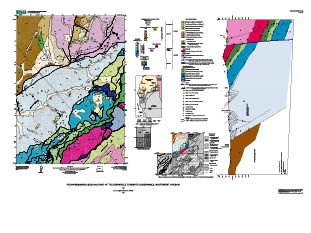
This study was undertaken as part of a contribution to 1:100,000 mapping of the Roseburg 30' x 60' quadrangle (Wells, et al., 2000). The purpose of this mapping was to assess the oil and gas potential of the Tertiary Tyee basin (see Ryu, et al., 1996). This database and accompanying plot file depict the distribution of geologic materials and structures at a large (1:24,000) scale. The report is intended to provide geologic information for the study of material properties, mineral resources, and geologic hazards. In addition, the report contains new information and interpretations about the regional geologic history and framework. However, the scale of this report does not provide sufficient detail for site development purposes. For example, landslides in the database are generalized and many smaller slope failures are not shown.
Are there legal restrictions on access or use of the data?Access_Constraints: none
Use_Constraints:Uses of this digital geologic map should not violate the spatial resolution of the data. Although the digital form of the data removes the constraint imposed by the scale of a paper map, the detail and accuracy inherent in map scale are also present in the digital data. The fact that this database was edited for a scale of 1:24,000 means that higher resolution information is not present in the dataset. Plotting at scales larger than 1:24,000 will not yield greater real detail, although it may reveal fine-scale irregularities below the intended resolution of the database. Similarly, where this database is used in combination with other data of higher resolution, the resolution of the combined output will be limited by the lower resolution of these data.
This report is preliminary and has not been reviewed for conformity with U.S. Geological Survey editorial standards or with the North American Stratigraphic Code. Any use of trade, firm, or product names is for descriptive purposes only and does not imply endorsement by the U.S. Government.
| Data format: | Exported coverages dix_geo, dix_stx, and dix_ann and supporting files in format ARCE (version 8.0.2) |
|---|---|
| Network links: |
http://pubs.usgs.gov/of/2001/0226/ofr01226md.tar.gz |