Geologic map and database of the Roseburg 30 x 60 minute quadrangle, Douglas and Coos Counties, Oregon

Metadata also available as - [Questions & Answers] - [Parseable text] - [XML]

Metadata:

Identification_Information:
Citation:
Citation_Information:
Originator: R.E. Wells
Originator: A.S. Jayko
Originator: A.R. Niem
Originator: G. Black
Originator: T. Wiley
Originator: E. Baldwin
Originator: K.M. Molenaar
Originator: K.L. Wheeler
Originator: C.B. DuRoss
Originator: R.W. Givler
Publication_Date: 2000
Title:
Geologic map and database of the Roseburg 30 x 60 minute quadrangle, Douglas and Coos Counties, Oregon
Edition: 1.0
Geospatial_Data_Presentation_Form: vector digital data
Series_Information:
Series_Name: U.S. Geological Survey Open-File Report
Issue_Identification: 00-376
Publication_Information:
Publication_Place: Menlo Park, CA
Publisher: U.S. Geological Survey
Online_Linkage: http://pubs.usgs.gov/of/2000/0376/
Description:
Abstract:
This digital map database, largely compiled from new mapping by the authors, represents the general distribution of bedrock and surficial deposits of the Roseburg 30 x 60 minute quadrangle along the southeastern margin of the Oregon Coast Range and its tectonic boundary with Mesozoic terranes of the Klamath Mountains. Together with the accompanying text files as PDF (rb_geol.pdf), it provides current information on the geologic structure and stratigraphy of the area covered. The database delineates map units that are identified by general age and lithology following the stratigraphic nomenclature of the U.S. Geological Survey. The scale of the source maps is 1:24,000, but the Quaternary contacts and structural data have been much simplified for the 1:100,000-scale map and database. The spatial resolution (scale) of the database is 1:100,000 or smaller.
Purpose:
This database and accompanying plot files depict the distribution of geologic materials and structures at a regional (1:100,000) scale. The report is intended to provide geologic information for the regional study of materials properties, earthquake shaking, landslide potential, mineral hazards, seismic velocity, and earthquake faults. In addition, the report contains new information and interpretations about the regional geologic history and framework. However, the regional scale of this report does not provide sufficient detail for site development purposes. In addition, this map does not take the place of fault-rupture hazard zones designated by the Oregon State Geologist. Similarly, the database cannot be used to identify or delineate landslides in the region.
Time_Period_of_Content:
Time_Period_Information:
Single_Date/Time:
Calendar_Date: 2000
Currentness_Reference: publication date
Status:
Progress: Complete
Maintenance_and_Update_Frequency: As needed
Spatial_Domain:
Bounding_Coordinates:
West_Bounding_Coordinate: -123.999929
East_Bounding_Coordinate: -122.999862
North_Bounding_Coordinate: 43.504374
South_Bounding_Coordinate: 42.995634
Keywords:
Theme:
Theme_Keyword_Thesaurus: USGS Thesaurus
Theme_Keyword: geology
Theme_Keyword: bedrock geologic units
Theme_Keyword: surficial geologic units
Theme_Keyword: geologic history
Theme_Keyword: geologic structure
Theme_Keyword: geospatial datasets
Theme:
Theme_Keyword_Thesaurus: none
Theme_Keyword: fault offset
Theme_Keyword: Oregon Coast Range
Theme_Keyword: Klamath Mountains
Theme_Keyword: Tyee basin
Theme_Keyword: Klamath terrane
Theme_Keyword: Roseburg, Oregon
Theme_Keyword: paleontology
Theme_Keyword: well
Theme_Keyword: Rogue arc complex
Theme_Keyword: Siletz River Volcanics
Theme_Keyword: Umpqua Group
Theme_Keyword: coccoliths
Theme_Keyword: Wildlife Safari fault
Theme_Keyword: Bonanza fault
Theme_Keyword: Cooper Creek fault
Theme_Keyword: Reston fault
Theme_Keyword: Western Cascade Arc
Theme_Keyword: Siletz terrane
Theme_Keyword: paleomagnetic data
Theme_Keyword: Tenmile Formation
Theme:
Theme_Keyword_Thesaurus: ISO 19115 Topic Categories
Theme_Keyword: geoscientificInformation
Place:
Place_Keyword_Thesaurus: none
Place_Keyword: Roseburg, Oregon
Place:
Place_Keyword_Thesaurus: Augmented FIPS 10-4 and FIPS 6-4
Place_Keyword: f41011 = Coos
Place_Keyword: f41019 = Douglas
Access_Constraints: none
Use_Constraints:
Uses of this digital geologic map should not violate the spatial resolution of the data. Although the digital form of the data removes the constraint imposed by the scale of a paper map, the detail and accuracy inherent in map scale are also present in the digital data. The fact that this database was edited for a scale of 1:100,000 means that higher resolution information is not present in the dataset. Plotting at scales larger than 1:100,000 will not yield greater real detail, although it may reveal fine- scale irregularities below the intended resolution of the database. Similarly, where this database is used in combination with other data of higher resolution, the resolution of the combined output will be limited by the lower resolution of these data.
Point_of_Contact:
Contact_Information:
Contact_Person_Primary:
Contact_Person: Wells, Ray E
Contact_Organization: USGS-GEO-WRG-NGM
Contact_Address:
Address_Type: mailing and physical address
Address:
Mail Stop 975, USGS
345 Middlefield Road
City: Menlo Park
State_or_Province: CA
Postal_Code: 94025
Country: US
Contact_Voice_Telephone: 650-329-4933
Contact_Electronic_Mail_Address: rwells@usgs.gov
Browse_Graphic:
Browse_Graphic_File_Name: http://pubs.usgs.gov/of/2000/0376/images/rb_sh1.gif
Browse_Graphic_File_Description:
A JPEG representation of Sheet 1, the geologic map at a scale of 1:100,000 and list of map units. 107 kilobytes.
Browse_Graphic_File_Type: GIF
Browse_Graphic:
Browse_Graphic_File_Name: http://pubs.usgs.gov/of/2000/0376/pdf/rb_sh1.pdf
Browse_Graphic_File_Description:
A PDF representation of Sheet 1, the geologic map at a scale of 1:100,000 and list of map units. 11 megabytes.
Browse_Graphic_File_Type: PDF
Browse_Graphic:
Browse_Graphic_File_Name: http://pubs.usgs.gov/of/2000/0376/pdf/rb_sh2.pdf
Browse_Graphic_File_Description:
A PDF representation of Sheet 2, the map key, index maps, and cross-sections at a scale of 1:100,000. 238 kilobytes.
Browse_Graphic_File_Type: PDF
Browse_Graphic:
Browse_Graphic_File_Name: http://pubs.usgs.gov/of/2000/0376/pdf/rb_geol.pdf
Browse_Graphic_File_Description:
A PDF representation of the explanatory geology and database pamphlet. 5 megabytes.
Browse_Graphic_File_Type: PDF
Browse_Graphic:
Browse_Graphic_File_Name: http://pubs.usgs.gov/of/2000/0376/pdf/rb_readme.pdf
Browse_Graphic_File_Description:
A PDF representation of the database description or readme pamphlet. 47 kilobytes.
Browse_Graphic_File_Type: PDF
Native_Data_Set_Environment: UNIX Sun Solaris; ESRI ArcInfo 7.1.2
Data_Quality_Information:
Lineage:
Source_Information:
Source_Citation:
Citation_Information:
Originator: Wiley, T. J.
Title:
Reconnaissance geologic map of the Dora and Sitkum quadrangles, Coos County, Oregon
Publication_Date: 1995
Series_Information:
Series_Name:
Oregon Department of Geology and Mineral Industries Geological Map Series
Issue_Identification: GMS-98
Source_Scale_Denominator: 24000
Type_of_Source_Media: paper
Source_Time_Period_of_Content:
Time_Period_Information:
Single_Date/Time:
Calendar_Date: 1995
Source_Currentness_Reference: publication date
Source_Citation_Abbreviation: Wiley (1995)
Source_Contribution: Dora and Sitkum quadrangles
Source_Information:
Source_Citation:
Citation_Information:
Originator: Wiley, T. J.
Originator: Priest, G.R.
Originator: Black, G. L.
Title:
Geologic map of the Mt. Gurney quadrangle, Douglas and Coos counties, Oregon
Publication_Date: 1994
Series_Information:
Series_Name:
Oregon Deptartment of Geology and Mineral Industries Geologic Map Series
Issue_Identification: GMS-85
Source_Scale_Denominator: 24000
Type_of_Source_Media: paper
Source_Time_Period_of_Content:
Time_Period_Information:
Single_Date/Time:
Calendar_Date: 1994
Source_Currentness_Reference: publication date
Source_Citation_Abbreviation: Wiley and others (1994)
Source_Contribution: Mt. Gurney quadrangle
Source_Information:
Source_Citation:
Citation_Information:
Originator: Black, G. L.
Title: Geologic map of the Reston quadrangle, Douglas County, Oregon
Publication_Date: 1990
Series_Information:
Series_Name:
Oregon Deptartment of Geology and Mineral Industries Geologic Map Series
Issue_Identification: GMS-68
Source_Scale_Denominator: 24000
Type_of_Source_Media: paper
Source_Time_Period_of_Content:
Time_Period_Information:
Single_Date/Time:
Calendar_Date: 1990
Source_Currentness_Reference: publication date
Source_Citation_Abbreviation: Black (1990)
Source_Contribution: Reston and Tenmile quadrangles
Source_Information:
Source_Citation:
Citation_Information:
Originator: Jayko, A. S. and Wells
Originator: R. E.
Title:
Reconnaissance geologic map of the Dixonville 7.5' quadrangle, Oregon
Publication_Date: 1999
Series_Information:
Series_Name: U.S. Geological Survey Open-File Report
Type_of_Source_Media: paper
Source_Time_Period_of_Content:
Time_Period_Information:
Single_Date/Time:
Calendar_Date: 1999
Source_Currentness_Reference: publication date
Source_Citation_Abbreviation: Jayko and R. E. (1999)
Source_Contribution: Dixonville quadrangle
Source_Information:
Source_Citation:
Citation_Information:
Originator: Jayko, A. S.
Title:
Reconnaissance geologic map of the Lane Mountain 7.5 minute quadrangle, Oregon
Publication_Date: 1996
Series_Information:
Series_Name: U.S. Geological Survey Open-File Report
Issue_Identification: 95-20
Type_of_Source_Media: paper
Source_Time_Period_of_Content:
Time_Period_Information:
Single_Date/Time:
Calendar_Date: 1996
Source_Currentness_Reference: publication date
Source_Citation_Abbreviation: Jayko (1996) lm
Source_Contribution: Lane Mountain quadrangle
Source_Information:
Source_Citation:
Citation_Information:
Originator: Jayko, A. S.
Title:
Reconnaissance geologic map of the White Rock 7.5 minute quadrangle, Oregon
Publication_Date: 1996
Series_Information:
Series_Name: U.S. Geological Survey Open-File Report
Type_of_Source_Media: paper
Source_Time_Period_of_Content:
Time_Period_Information:
Single_Date/Time:
Calendar_Date: 1996
Source_Currentness_Reference: publication date
Source_Citation_Abbreviation: Jayko (1996) wr
Source_Contribution: White Rock quadrangle
Source_Information:
Source_Citation:
Citation_Information:
Originator: Black, G. L.
Title:
Geologic map of the Kenyon Mountain quadrangle, Douglas and Coos counties, Oregon
Publication_Date: 1994
Series_Information:
Series_Name:
Oregon Deptartment of Geology and Mineral Industries Geologic Map Series
Issue_Identification: GMS-83
Source_Scale_Denominator: 24000
Type_of_Source_Media: paper
Source_Time_Period_of_Content:
Time_Period_Information:
Single_Date/Time:
Calendar_Date: 1994
Source_Currentness_Reference: publication date
Source_Citation_Abbreviation: Black (1994)
Source_Information:
Source_Citation:
Citation_Information:
Originator: Black, G. L.
Title: Geologic map of the Remote quadrangle, Coos County, Oregon
Publication_Date: 1994
Series_Information:
Series_Name:
Oregon Deptartment of Geology and Mineral Industries Geologic Map Series
Issue_Identification: GMS-84
Source_Scale_Denominator: 24000
Type_of_Source_Media: paper
Source_Time_Period_of_Content:
Time_Period_Information:
Single_Date/Time:
Calendar_Date: 1994
Source_Currentness_Reference: publication date
Source_Citation_Abbreviation: Black (1994)
Source_Contribution: Remote quadrangle
Source_Information:
Source_Citation:
Citation_Information:
Originator: Black, G. L. and Priest
Originator: G. R.
Title:
Geologic map of the Camas Valley quadrangle, Douglas and Coos counties, Oregon
Publication_Date: 1993
Series_Information:
Series_Name:
Oregon Deptartment of Geology and Mineral Industries Geologic Map Series
Issue_Identification: GMS-76
Source_Scale_Denominator: 24000
Type_of_Source_Media: paper
Source_Time_Period_of_Content:
Time_Period_Information:
Single_Date/Time:
Calendar_Date: 1993
Source_Currentness_Reference: publication date
Source_Citation_Abbreviation: Black and G. R. (1993)
Source_Contribution: Camas Valley quadrangle
Source_Information:
Source_Citation:
Citation_Information:
Originator: Jayko, A. S. and Gallagher
Originator: M.
Title:
Reconnaissance geologic map of the Myrtle Creek 7.5' quadrangle, Oregon
Publication_Date: 1997
Series_Information:
Series_Name: U.S. Geological Survey Open-File Report
Type_of_Source_Media: paper
Source_Time_Period_of_Content:
Time_Period_Information:
Single_Date/Time:
Calendar_Date: 1997
Source_Currentness_Reference: publication date
Source_Citation_Abbreviation: Jayko and M. (1997)
Source_Contribution: Myrtle Creek quadrangle
Source_Information:
Source_Citation:
Citation_Information:
Originator: Jayko, A. S.
Title:
Reconnaissance geologic map of the Dodson Butte 7.5' quadrangle, Oregon
Publication_Date: 1997
Series_Information:
Series_Name: U.S. Geological Survey Open-File Report
Type_of_Source_Media: paper
Source_Time_Period_of_Content:
Time_Period_Information:
Single_Date/Time:
Calendar_Date: 1997
Source_Currentness_Reference: publication date
Source_Citation_Abbreviation: Jayko (1997)
Source_Contribution: Dodson Butte quadrangle
Process_Step:
Process_Description:
Mapping of individual 7.5 minute quadrangles within the Roseburg 30 x 60 minute quadrangle was accomplished by the authors as follows:
 Golden Falls:     Molenaar, Black, Wells (1996)
 Ivers Peak:       Molenaar, Black, Wells, Wheeler (1996)
 Kelly Butte:      Baldwin, unpublished, Wells
 Tyee:             Baldwin, unpublished, Wells
 Tyee Mountain:    Wells, 1994 mapping
 Sutherlin:        Wells, 1994 mapping
 Nonpareil:        Wells, 1994 mapping
 Hinkle Creek:     Wells, 1995 mapping
 Coos Mountain:    Molenaar, Black, Wells (1996)
 Tioga:            Wells, Molenaar and Black (1996)
 Cedar Creek:      Wells, 1995 mapping
 Callahan:         Wells and Smith, 1994 mapping
 Garden Valley:    Felger, Abolins, and Wells (1992)
 Winchester:       Wells, 1992 mapping
 Oak Creek Valley: Wells, 1993 mapping
 Glide:            Wells and Niem, 1995 mapping
 Dora:             Wiley (1995)
 Sitkum:           Wiley (1995)
 Mt. Gurney:       Wiley, Priest and Black (1994)
 Reston:           Black (1990)
 Roseburg West:    Wells, 1990-1991 mapping
 Roseburg East:    Wells, 1990-1991 mapping
 Dixonville:       Jayko and Wells (1999)
 Lane Mountain:    Jayko(1996)
 Remote:           Black (1995)
 Kenyon Mountain:  Black (1994)
 Camas Valley:     Black and Priest (1993)
 Tenmile:          Black (1990)
 Winston:          Jayko (unpublished mapping)
 Myrtle Creek:     Jayko and Gallagher (1997)
 Dodson Butte:     Jayko (1997)
 White Rock:       Jayko (1996)
Process_Date: 1990 - 1999
Source_Produced_Citation_Abbreviation: Wiley (1995)
Source_Produced_Citation_Abbreviation: Wiley and others (1994)
Source_Produced_Citation_Abbreviation: Black (1990)
Source_Produced_Citation_Abbreviation: Jayko and R. E. (1999)
Source_Produced_Citation_Abbreviation: Jayko (1996) lm
Source_Produced_Citation_Abbreviation: Jayko (1996) wr
Source_Produced_Citation_Abbreviation: Black (1994)
Source_Produced_Citation_Abbreviation: Black and G. R. (1993)
Source_Produced_Citation_Abbreviation: Jayko and M. (1997)
Source_Produced_Citation_Abbreviation: Jayko (1997)
Process_Step:
Process_Description:
The databases in this report were compiled in ARC/INFO, a commercial Geographic Information System (Environmental Systems Research Institute, Redlands, California, with version 3.0 of the menu interface ALACARTE (Fitzgibbon and Wentworth, 1991, Fitzgibbon, 1991, Wentworth and Fitzgibbon, 1991). The files are in either GRID (ARC/INFO raster data) format or COVERAGE (ARC/ INFO vector data) format. Coverages are stored in uncompressed ARC export format (ARC/INFO version 7.x). ARC/INFO export files (files with the .e00 extension) can be converted into ARC/ INFO coverages in ARC/INFO (see below) and can be read by some other Geographic Information Systems, such as MapInfo via ArcLink and ESRI's ArcView (version 1.0 for Windows 3.1 to 3.11 is available for free from ESRI's web site: http://www.esri.com). The digital compilation was done in version 7.1.1 of ARC/INFO with version 3.0 of the menu interface ALACARTE (Fitzgibbon and Wentworth, 1991, Fitzgibbon, 1991, Wentworth and Fitzgibbon, 1991). The geologic map information was digitized from stable originals of the geologic maps at 1:24,000 scale. The author manuscripts (pen on mylar and pen on paper) were scanned using a Ideal rasterizing color scanner with a resolution of 600 and 400 dots per inch. The scanned images were vectorized and transformed from scanner coordinates to projection coordinates with digital tics placed by hand at quadrangle corners. The scanned lines were edited interactively by hand using ALACARTE, color boundaries were tagged as appropriate, and scanning artifacts visible at 1:24,000 were removed. The individual digital maps at 1:24,000 were used to create the regional 1:100, 000-scale map in ARC/INFO, and the features that were too small in area or so dense in number and location, were removed from the database to simplify the map.
Process_Date: 1990 - 1999
Process_Step:
Process_Description: Creation of original metadata record
Process_Date: 20000919
Process_Contact:
Contact_Information:
Contact_Person_Primary:
Contact_Person: Karen L. Wheeler
Contact_Organization: U.S. Geological Survey
Contact_Position: Geologist/GIS
Contact_Address:
Address_Type: mailing and physical address
Address:
U.S. Geological Survey
Western Earth Surface Processes Team
345 Middlefield Road, Mail Stop 975
City: Menlo Park
State_or_Province: CA
Postal_Code: 94025
Country: USA
Contact_Voice_Telephone: 650-329-4935
Contact_Facsimile_Telephone: 650-329-4936
Contact_Electronic_Mail_Address: kwheeler@usgs.gov
Spatial_Data_Organization_Information:
Direct_Spatial_Reference_Method: Vector
Point_and_Vector_Object_Information:
SDTS_Terms_Description:
SDTS_Point_and_Vector_Object_Type: Complete chain
SDTS_Terms_Description:
SDTS_Point_and_Vector_Object_Type: Entity point
SDTS_Terms_Description:
SDTS_Point_and_Vector_Object_Type: GT-polygon composed of chains
SDTS_Terms_Description:
SDTS_Point_and_Vector_Object_Type: Point
SDTS_Terms_Description:
SDTS_Point_and_Vector_Object_Type: Label point
Spatial_Reference_Information:
Horizontal_Coordinate_System_Definition:
Planar:
Grid_Coordinate_System:
Grid_Coordinate_System_Name: Universal Transverse Mercator
Universal_Transverse_Mercator:
UTM_Zone_Number: 10
Transverse_Mercator:
Scale_Factor_at_Central_Meridian: 0.9996
Longitude_of_Central_Meridian: -123
Latitude_of_Projection_Origin: 0.0
False_Easting: 500000
False_Northing: 0.0
Planar_Coordinate_Information:
Planar_Coordinate_Encoding_Method: coordinate pair
Coordinate_Representation:
Abscissa_Resolution: 0.000128
Ordinate_Resolution: 0.000128
Planar_Distance_Units: meters
Geodetic_Model:
Horizontal_Datum_Name: North American Datum of 1927
Ellipsoid_Name: Clarke 1866
Semi-major_Axis: 6378206.4
Denominator_of_Flattening_Ratio: 294.98
Entity_and_Attribute_Information:
Overview_Description:
Entity_and_Attribute_Overview:
Because these data were created in Arc/Info, polygons are described by tables fitting the pattern cover.pat (here and after, "cover" refers to the name of the Arc/Info coverage). These contain the general attributes AREA, PERIMETER, cover#, and cover-ID. Likewise, lines are described by tables named cover.aat, and contain topological as well as general attributes FNODE#, TNODE#, LPOLY#, RPOLY#, LENGTH, cover#, and cover-ID.
Because these data were created using Alacarte, the feature attribute tables also include the attributes LTYPE for lines and PTYPE for points and polygons, as well as SEL, which is used internally by Alacarte to mark features that are selected, and SYMB, which is used internally by Alacarte to symbolize the features for display. Additional attributes that contain scientific information may also be present, and are described in detail here.
Entity_and_Attribute_Detail_Citation: http://pubs.usgs.gov/of/2000/0376/pdf/rb_geol.pdf
Detailed_Description:
Entity_Type:
Entity_Type_Label: rb_geol.pat
Entity_Type_Definition: Geologic units
Attribute:
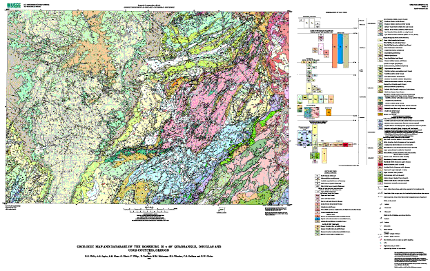
Attribute_Label: PTYPE
Attribute_Definition: Geologic unit label
Attribute_Domain_Values:
Enumerated_Domain:
Enumerated_Domain_Value: Qf
Enumerated_Domain_Value_Definition: Fluvial deposits (Holocene)
Attribute_Domain_Values:
Enumerated_Domain:
Enumerated_Domain_Value: Qcl
Enumerated_Domain_Value_Definition: Colluvium (Holocene and Pleistocene)
Attribute_Domain_Values:
Enumerated_Domain:
Enumerated_Domain_Value: Qls
Enumerated_Domain_Value_Definition: Landslide deposits (Holocene and Pleistocene)
Attribute_Domain_Values:
Enumerated_Domain:
Enumerated_Domain_Value: Qft
Enumerated_Domain_Value_Definition: Fluvial terrace deposits (Pleistocene)
Attribute_Domain_Values:
Enumerated_Domain:
Enumerated_Domain_Value: Qoft
Enumerated_Domain_Value_Definition: Older Fluvial terrace deposits (Pleistocene)
Attribute_Domain_Values:
Enumerated_Domain:
Enumerated_Domain_Value: Td
Enumerated_Domain_Value_Definition: Upper dacite (late Eocene)
Attribute_Domain_Values:
Enumerated_Domain:
Enumerated_Domain_Value: Tbcu
Enumerated_Domain_Value_Definition: Tuff of Bond Creek (late Eocene) upper unit
Attribute_Domain_Values:
Enumerated_Domain:
Enumerated_Domain_Value: Tbcl
Enumerated_Domain_Value_Definition: Tuff of Bond Creek (late Eocene) lower unit
Attribute_Domain_Values:
Enumerated_Domain:
Enumerated_Domain_Value: Tbf
Enumerated_Domain_Value_Definition: Basalt of Brown Mountain (late Eocene)
Attribute_Domain_Values:
Enumerated_Domain:
Enumerated_Domain_Value: Taf
Enumerated_Domain_Value_Definition: Andesite flows (late Eocene)
Attribute_Domain_Values:
Enumerated_Domain:
Enumerated_Domain_Value: Tsf
Enumerated_Domain_Value_Definition: Rhyolite and dacite flows (late Eocene)
Attribute_Domain_Values:
Enumerated_Domain:
Enumerated_Domain_Value: Tvs
Enumerated_Domain_Value_Definition:
Volcanolithic sandstone, conglomerate, and laharic breccia (late Eocene)
Attribute_Domain_Values:
Enumerated_Domain:
Enumerated_Domain_Value: Tc
Enumerated_Domain_Value_Definition: Colestin Formation (late Eocene?)
Attribute_Domain_Values:
Enumerated_Domain:
Enumerated_Domain_Value: Tis
Enumerated_Domain_Value_Definition: Rhyolite and dacite intrusions (late and middle Eocene)
Attribute_Domain_Values:
Enumerated_Domain:
Enumerated_Domain_Value: Tib
Enumerated_Domain_Value_Definition: Diabase and basalt intrusions (late and middle Eocene)
Attribute_Domain_Values:
Enumerated_Domain:
Enumerated_Domain_Value: Tia
Enumerated_Domain_Value_Definition: Andesite dikes and sills (late and middle Eocene)
Attribute_Domain_Values:
Enumerated_Domain:
Enumerated_Domain_Value: Tes
Enumerated_Domain_Value_Definition: Spencer Formation (late and middle Eocene)
Attribute_Domain_Values:
Enumerated_Domain:
Enumerated_Domain_Value: Teb
Enumerated_Domain_Value_Definition: Bateman Formation (late and middle Eocene)
Attribute_Domain_Values:
Enumerated_Domain:
Enumerated_Domain_Value: Tebm
Enumerated_Domain_Value_Definition: Bateman Formation mudstone (late and middle Eocene)
Attribute_Domain_Values:
Enumerated_Domain:
Enumerated_Domain_Value: Tee
Enumerated_Domain_Value_Definition: Elkton Formation mudstone (middle Eocene)
Attribute_Domain_Values:
Enumerated_Domain:
Enumerated_Domain_Value: Ttbs
Enumerated_Domain_Value_Definition: Tyee Formation, Baughman Member (middle Eocene)
Attribute_Domain_Values:
Enumerated_Domain:
Enumerated_Domain_Value: Ttbm
Enumerated_Domain_Value_Definition:
Tyee Formation, Baughman Member mudstone (middle and early Eocene)
Attribute_Domain_Values:
Enumerated_Domain:
Enumerated_Domain_Value: Tth
Enumerated_Domain_Value_Definition: Tyee Formation, Hubbard Creek Member (middle and early Eocene)
Attribute_Domain_Values:
Enumerated_Domain:
Enumerated_Domain_Value: Tths
Enumerated_Domain_Value_Definition: Tyee Formation, Hubbard Creek Member sandstone (middle Eocene)
Attribute_Domain_Values:
Enumerated_Domain:
Enumerated_Domain_Value: Ttts
Enumerated_Domain_Value_Definition: Tyee Formation, Tyee Mountain Member (middle and early Eocene)
Attribute_Domain_Values:
Enumerated_Domain:
Enumerated_Domain_Value: Tttm
Enumerated_Domain_Value_Definition:
Tyee Formation, Tyee Mountain Member mudstone (middle and early Eocene)
Attribute_Domain_Values:
Enumerated_Domain:
Enumerated_Domain_Value: Tcv
Enumerated_Domain_Value_Definition: Camas Valley Formation (early Eocene)
Attribute_Domain_Values:
Enumerated_Domain:
Enumerated_Domain_Value: Tw
Enumerated_Domain_Value_Definition: White Tail Ridge Formation, undivided (early Eocene)
Attribute_Domain_Values:
Enumerated_Domain:
Enumerated_Domain_Value: Twrc
Enumerated_Domain_Value_Definition: White Tail Ridge Formation, Rasler Creek tongue (early Eocene)
Attribute_Domain_Values:
Enumerated_Domain:
Enumerated_Domain_Value: Twc
Enumerated_Domain_Value_Definition:
White Tail Ridge Formation, Coquille River Member (early Eocene)
Attribute_Domain_Values:
Enumerated_Domain:
Enumerated_Domain_Value: Twr
Enumerated_Domain_Value_Definition: White Tail Ridge Formation, Remote Member (early Eocene)
Attribute_Domain_Values:
Enumerated_Domain:
Enumerated_Domain_Value: Twrm
Enumerated_Domain_Value_Definition:
White Tail Ridge Formation, Remote Member Mudstone (early Eocene)
Attribute_Domain_Values:
Enumerated_Domain:
Enumerated_Domain_Value: Twbc
Enumerated_Domain_Value_Definition: White Tail Ridge Formation, Berry Creek Member (early Eocene)
Attribute_Domain_Values:
Enumerated_Domain:
Enumerated_Domain_Value: Twst
Enumerated_Domain_Value_Definition:
White Tail Ridge Formation, Unnamed siltstone member (early Eocene)
Attribute_Domain_Values:
Enumerated_Domain:
Enumerated_Domain_Value: Tm
Enumerated_Domain_Value_Definition: Tenmile Formation, undivided (early Eocene)
Attribute_Domain_Values:
Enumerated_Domain:
Enumerated_Domain_Value: Tmsl
Enumerated_Domain_Value_Definition: Tenmile Formation, Slope mudstone (early Eocene)
Attribute_Domain_Values:
Enumerated_Domain:
Enumerated_Domain_Value: Tmsm
Enumerated_Domain_Value_Definition:
Tenmile Formation, Turbidite sandstone and mudstone (early Eocene)
Attribute_Domain_Values:
Enumerated_Domain:
Enumerated_Domain_Value: Tmss
Enumerated_Domain_Value_Definition: Tenmile Formation, Turbidite sandstone (early Eocene)
Attribute_Domain_Values:
Enumerated_Domain:
Enumerated_Domain_Value: Tmm
Enumerated_Domain_Value_Definition: Tenmile Formation, Basin plain mudstone (early Eocene)
Attribute_Domain_Values:
Enumerated_Domain:
Enumerated_Domain_Value: Tmms
Enumerated_Domain_Value_Definition:
Tenmile Formation, Mudstone and turbidite sandstone (early Eocene)
Attribute_Domain_Values:
Enumerated_Domain:
Enumerated_Domain_Value: Tmcs
Enumerated_Domain_Value_Definition:
Tenmile Formation, Submarine fan channel sandstone (early Eocene)
Attribute_Domain_Values:
Enumerated_Domain:
Enumerated_Domain_Value: Tbsc
Enumerated_Domain_Value_Definition: Bushnell Rock Formation, Slater Creek Member (early Eocene)
Attribute_Domain_Values:
Enumerated_Domain:
Enumerated_Domain_Value: Tbr
Enumerated_Domain_Value_Definition: Bushnell Rock Formation, conglomerate (early Eocene)
Attribute_Domain_Values:
Enumerated_Domain:
Enumerated_Domain_Value: Tbrm
Enumerated_Domain_Value_Definition: Bushnell Rock Formation, Debris flow deposits (early Eocene)
Attribute_Domain_Values:
Enumerated_Domain:
Enumerated_Domain_Value: Trbs
Enumerated_Domain_Value_Definition:
Siletz River Volcanics, Roseburg Member, Basaltic sandstone (early Eocene)
Attribute_Domain_Values:
Enumerated_Domain:
Enumerated_Domain_Value: Trs
Enumerated_Domain_Value_Definition:
Siletz River Volcanics, Roseburg Member, Turbidite sandstone and mudstone (early Eocene)
Attribute_Domain_Values:
Enumerated_Domain:
Enumerated_Domain_Value: Trc
Enumerated_Domain_Value_Definition:
Siletz River Volcanics, Roseburg Member, Conglomerate (early Eocene)
Attribute_Domain_Values:
Enumerated_Domain:
Enumerated_Domain_Value: Tsrt
Enumerated_Domain_Value_Definition: Siletz River Volcanics, Basalt tuff (early Eocene)
Attribute_Domain_Values:
Enumerated_Domain:
Enumerated_Domain_Value: Tsru
Enumerated_Domain_Value_Definition:
Siletz River Volcanics, Subaerial basalt flows (early Eocene and late Paleocene)
Attribute_Domain_Values:
Enumerated_Domain:
Enumerated_Domain_Value: Tsr
Enumerated_Domain_Value_Definition: Siletz River Volcanics, submarine basalt flows (early Eocene)
Attribute_Domain_Values:
Enumerated_Domain:
Enumerated_Domain_Value: Tidb
Enumerated_Domain_Value_Definition: Diabase (early Eocene)
Attribute_Domain_Values:
Enumerated_Domain:
Enumerated_Domain_Value: KJda
Enumerated_Domain_Value_Definition:
Dothan Formation, turbidite sandstone broken formation (early Cretaceous and late Jurassic)
Attribute_Domain_Values:
Enumerated_Domain:
Enumerated_Domain_Value: KJdm
Enumerated_Domain_Value_Definition:
Dothan Formation, mudstone matrix melange (early Cretaceous and late Jurassic)
Attribute_Domain_Values:
Enumerated_Domain:
Enumerated_Domain_Value: KJdd
Enumerated_Domain_Value_Definition:
Dothan Formation, phyllitic siltstone and metagreywacke (early Cretaceous and late Jurassic)
Attribute_Domain_Values:
Enumerated_Domain:
Enumerated_Domain_Value: KJd2
Enumerated_Domain_Value_Definition:
Dothan Formation, semischist and phyllite (early Cretaceous and late Jurassic)
Attribute_Domain_Values:
Enumerated_Domain:
Enumerated_Domain_Value: Kdc
Enumerated_Domain_Value_Definition:
Myrtle Group, Days Creek Formation (middle and early Cretaceous)
Attribute_Domain_Values:
Enumerated_Domain:
Enumerated_Domain_Value: KJr
Enumerated_Domain_Value_Definition: Riddle Formation (Early Cretaceous to Late Jurassic?)
Attribute_Domain_Values:
Enumerated_Domain:
Enumerated_Domain_Value: KJrc
Enumerated_Domain_Value_Definition:
Riddle Formation conglomerate (Early Cretaceous to Late Jurassic?)
Attribute_Domain_Values:
Enumerated_Domain:
Enumerated_Domain_Value: KJms
Enumerated_Domain_Value_Definition: Metasedimentary rock (early Cretaceous and late Jurassic)
Attribute_Domain_Values:
Enumerated_Domain:
Enumerated_Domain_Value: KJhf
Enumerated_Domain_Value_Definition: Mafic silicified hornfels (Cretaceous, Jurassic, or both)
Attribute_Domain_Values:
Enumerated_Domain:
Enumerated_Domain_Value: KJag
Enumerated_Domain_Value_Definition: Augen gneiss (Cretaceous, Jurassic, or both)
Attribute_Domain_Values:
Enumerated_Domain:
Enumerated_Domain_Value: KJi
Enumerated_Domain_Value_Definition: Intrusive rocks (Cretaceous, Jurassic, or both)
Attribute_Domain_Values:
Enumerated_Domain:
Enumerated_Domain_Value: KJgd
Enumerated_Domain_Value_Definition: Granodiorite (Cretaceous, Jurassic, or both)
Attribute_Domain_Values:
Enumerated_Domain:
Enumerated_Domain_Value: KJhd
Enumerated_Domain_Value_Definition: Hornblende diorite (Cretaceous, Jurassic, or both)
Attribute_Domain_Values:
Enumerated_Domain:
Enumerated_Domain_Value: KJdi
Enumerated_Domain_Value_Definition: Diorite (Cretaceous, Jurassic, or both)
Attribute_Domain_Values:
Enumerated_Domain:
Enumerated_Domain_Value: KJdt
Enumerated_Domain_Value_Definition: Tectonized diorite (Cretaceous, Jurassic, or both)
Attribute_Domain_Values:
Enumerated_Domain:
Enumerated_Domain_Value: m
Enumerated_Domain_Value_Definition: Metamorphic complex (Jurassic or older)
Attribute_Domain_Values:
Enumerated_Domain:
Enumerated_Domain_Value: Jrv
Enumerated_Domain_Value_Definition: Rogue volcanics? (late Jurassic?)
Attribute_Domain_Values:
Enumerated_Domain:
Enumerated_Domain_Value: Jri
Enumerated_Domain_Value_Definition: Mafic intrusive unit (late Jurassic?)
Attribute_Domain_Values:
Enumerated_Domain:
Enumerated_Domain_Value: Jrvs
Enumerated_Domain_Value_Definition: Schistose Rogue volcanics (late Jurassic)
Attribute_Domain_Values:
Enumerated_Domain:
Enumerated_Domain_Value: Jris
Enumerated_Domain_Value_Definition: Schistose mafic intrusive unit (late Jurassic)
Attribute_Domain_Values:
Enumerated_Domain:
Enumerated_Domain_Value: Jrs
Enumerated_Domain_Value_Definition: Serpentinized ultramafic rock (Jurassic?)
Attribute_Domain_Values:
Enumerated_Domain:
Enumerated_Domain_Value: amp
Attribute_Domain_Values:
Enumerated_Domain:
Enumerated_Domain_Value: bs
Attribute_Domain_Values:
Enumerated_Domain:
Enumerated_Domain_Value: cht
Attribute_Domain_Values:
Enumerated_Domain:
Enumerated_Domain_Value: di
Attribute_Domain_Values:
Enumerated_Domain:
Enumerated_Domain_Value: dio
Attribute_Domain_Values:
Enumerated_Domain:
Enumerated_Domain_Value: gs
Attribute_Domain_Values:
Enumerated_Domain:
Enumerated_Domain_Value: gs-di
Attribute_Domain_Values:
Enumerated_Domain:
Enumerated_Domain_Value: kn
Attribute_Domain_Values:
Enumerated_Domain:
Enumerated_Domain_Value: ls
Attribute_Domain_Values:
Enumerated_Domain:
Enumerated_Domain_Value: mv
Attribute_Domain_Values:
Enumerated_Domain:
Enumerated_Domain_Value: sp
Attribute_Domain_Values:
Enumerated_Domain:
Enumerated_Domain_Value: sp+gs
Attribute_Domain_Values:
Enumerated_Domain:
Enumerated_Domain_Value: water
Detailed_Description:
Entity_Type:
Entity_Type_Label: rg_geol.aat
Entity_Type_Definition: Geologically-significant linear features
Attribute:
Attribute_Label: LTYPE
Attribute_Definition: Line type
Attribute_Domain_Values:
Enumerated_Domain:
Enumerated_Domain_Value: atten. fault, certain
Attribute_Domain_Values:
Enumerated_Domain:
Enumerated_Domain_Value: atten. fault, concealed
Attribute_Domain_Values:
Enumerated_Domain:
Enumerated_Domain_Value: atten. fault, inferred
Attribute_Domain_Values:
Enumerated_Domain:
Enumerated_Domain_Value: atten. fault, inferred, queried
Attribute_Domain_Values:
Enumerated_Domain:
Enumerated_Domain_Value: contact, certain
Attribute_Domain_Values:
Enumerated_Domain:
Enumerated_Domain_Value: contact, concealed
Attribute_Domain_Values:
Enumerated_Domain:
Enumerated_Domain_Value: contact, concealed, queried
Attribute_Domain_Values:
Enumerated_Domain:
Enumerated_Domain_Value: contact, inferred
Attribute_Domain_Values:
Enumerated_Domain:
Enumerated_Domain_Value: contact, inferred, queried
Attribute_Domain_Values:
Enumerated_Domain:
Enumerated_Domain_Value: dike
Attribute_Domain_Values:
Enumerated_Domain:
Enumerated_Domain_Value: fault inferred
Attribute_Domain_Values:
Enumerated_Domain:
Enumerated_Domain_Value: fault, approx. located
Attribute_Domain_Values:
Enumerated_Domain:
Enumerated_Domain_Value: fault, certain
Attribute_Domain_Values:
Enumerated_Domain:
Enumerated_Domain_Value: fault, certainm
Attribute_Domain_Values:
Enumerated_Domain:
Enumerated_Domain_Value: fault, concealed
Attribute_Domain_Values:
Enumerated_Domain:
Enumerated_Domain_Value: fault, concealed, queried
Attribute_Domain_Values:
Enumerated_Domain:
Enumerated_Domain_Value: detachment fault, certain
Attribute_Domain_Values:
Enumerated_Domain:
Enumerated_Domain_Value: detachment fault, inferred
Attribute_Domain_Values:
Enumerated_Domain:
Enumerated_Domain_Value: detachment fault, inferred, queried
Attribute_Domain_Values:
Enumerated_Domain:
Enumerated_Domain_Value: fault, inferred
Attribute_Domain_Values:
Enumerated_Domain:
Enumerated_Domain_Value: fault, inferred, queried
Attribute_Domain_Values:
Enumerated_Domain:
Enumerated_Domain_Value: map boundary, certain
Attribute_Domain_Values:
Enumerated_Domain:
Enumerated_Domain_Value: normal fault, certain
Attribute_Domain_Values:
Enumerated_Domain:
Enumerated_Domain_Value: normal fault, certainm
Attribute_Domain_Values:
Enumerated_Domain:
Enumerated_Domain_Value: normal fault, concealed
Attribute_Domain_Values:
Enumerated_Domain:
Enumerated_Domain_Value: normal fault, concealedm
Attribute_Domain_Values:
Enumerated_Domain:
Enumerated_Domain_Value: normal fault, inferred
Attribute_Domain_Values:
Enumerated_Domain:
Enumerated_Domain_Value: normal fault, inferred, queried
Attribute_Domain_Values:
Enumerated_Domain:
Enumerated_Domain_Value: normal fault, inferred, queriedm
Attribute_Domain_Values:
Enumerated_Domain:
Enumerated_Domain_Value: normal fault, inferredm
Attribute_Domain_Values:
Enumerated_Domain:
Enumerated_Domain_Value: s.s. fault, l.l., certain
Attribute_Domain_Values:
Enumerated_Domain:
Enumerated_Domain_Value: s.s. fault, r.l., certain
Attribute_Domain_Values:
Enumerated_Domain:
Enumerated_Domain_Value: s.s. fault, r.l., concealed
Attribute_Domain_Values:
Enumerated_Domain:
Enumerated_Domain_Value: scratch boundary, certain
Attribute_Domain_Values:
Enumerated_Domain:
Enumerated_Domain_Value: shear zone, certain
Attribute_Domain_Values:
Enumerated_Domain:
Enumerated_Domain_Value: thrust fault, certain
Attribute_Domain_Values:
Enumerated_Domain:
Enumerated_Domain_Value: thrust fault, concealed
Attribute_Domain_Values:
Enumerated_Domain:
Enumerated_Domain_Value: thrust fault, concealed, queried
Attribute_Domain_Values:
Enumerated_Domain:
Enumerated_Domain_Value: thrust fault, inferred
Attribute_Domain_Values:
Enumerated_Domain:
Enumerated_Domain_Value: thrust fault, inferred, queried
Attribute_Domain_Values:
Enumerated_Domain:
Enumerated_Domain_Value: thrust fault, inferred, queried_
Attribute_Domain_Values:
Enumerated_Domain:
Enumerated_Domain_Value: water boundary, certain
Detailed_Description:
Entity_Type:
Entity_Type_Label: rb_well.pat
Attribute:
Attribute_Label: NUMB
Attribute:
Attribute_Label: WELLNUMB
Attribute:
Attribute_Label: LONG1
Attribute:
Attribute_Label: LAT1
Attribute:
Attribute_Label: WELLDEPTH
Attribute:
Attribute_Label: WELLNAME
Attribute:
Attribute_Label: QUAD1
Attribute:
Attribute_Label: $ID
Attribute:
Attribute_Label: $POLYGONID
Attribute:
Attribute_Label: $SCALE
Attribute:
Attribute_Label: $ANGLE
Detailed_Description:
Entity_Type:
Entity_Type_Label: rb_stx.pat
Attribute:
Attribute_Label: PTTYPE
Attribute_Domain_Values:
Enumerated_Domain:
Enumerated_Domain_Value: _l_lineation_i_
Attribute_Domain_Values:
Enumerated_Domain:
Enumerated_Domain_Value: air photo attitude
Attribute_Domain_Values:
Enumerated_Domain:
Enumerated_Domain_Value: anticline
Attribute_Domain_Values:
Enumerated_Domain:
Enumerated_Domain_Value: bedding
Attribute_Domain_Values:
Enumerated_Domain:
Enumerated_Domain_Value: bedding w/tops
Attribute_Domain_Values:
Enumerated_Domain:
Enumerated_Domain_Value: crumpled bedding
Attribute_Domain_Values:
Enumerated_Domain:
Enumerated_Domain_Value: crumpled foliation
Attribute_Domain_Values:
Enumerated_Domain:
Enumerated_Domain_Value: fault dip
Attribute_Domain_Values:
Enumerated_Domain:
Enumerated_Domain_Value: fault plane
Attribute_Domain_Values:
Enumerated_Domain:
Enumerated_Domain_Value: fault, ss, ll
Attribute_Domain_Values:
Enumerated_Domain:
Enumerated_Domain_Value: fault, ss, rl
Attribute_Domain_Values:
Enumerated_Domain:
Enumerated_Domain_Value: flat bedding
Attribute_Domain_Values:
Enumerated_Domain:
Enumerated_Domain_Value: flow_2dir
Attribute_Domain_Values:
Enumerated_Domain:
Enumerated_Domain_Value: flow_dir
Attribute_Domain_Values:
Enumerated_Domain:
Enumerated_Domain_Value: fold axis
Attribute_Domain_Values:
Enumerated_Domain:
Enumerated_Domain_Value: fold_axis
Attribute_Domain_Values:
Enumerated_Domain:
Enumerated_Domain_Value: foliation
Attribute_Domain_Values:
Enumerated_Domain:
Enumerated_Domain_Value: foliation and bedding
Attribute_Domain_Values:
Enumerated_Domain:
Enumerated_Domain_Value: igneous foliation
Attribute_Domain_Values:
Enumerated_Domain:
Enumerated_Domain_Value: inclined cleavage
Attribute_Domain_Values:
Enumerated_Domain:
Enumerated_Domain_Value: joint
Attribute_Domain_Values:
Enumerated_Domain:
Enumerated_Domain_Value: joint unmineralized
Attribute_Domain_Values:
Enumerated_Domain:
Enumerated_Domain_Value: _l_slick_i_r_
Attribute_Domain_Values:
Enumerated_Domain:
Enumerated_Domain_Value: lava_tube
Attribute_Domain_Values:
Enumerated_Domain:
Enumerated_Domain_Value: lineation
Attribute_Domain_Values:
Enumerated_Domain:
Enumerated_Domain_Value: ot bedding
Attribute_Domain_Values:
Enumerated_Domain:
Enumerated_Domain_Value: ot bedding w/tops
Attribute_Domain_Values:
Enumerated_Domain:
Enumerated_Domain_Value: slick
Attribute_Domain_Values:
Enumerated_Domain:
Enumerated_Domain_Value: small syncline
Attribute_Domain_Values:
Enumerated_Domain:
Enumerated_Domain_Value: vert bedding
Attribute_Domain_Values:
Enumerated_Domain:
Enumerated_Domain_Value: vert bedding w/tops
Attribute_Domain_Values:
Enumerated_Domain:
Enumerated_Domain_Value: vert foliation
Attribute_Domain_Values:
Enumerated_Domain:
Enumerated_Domain_Value: vert foliation and bedding
Attribute_Domain_Values:
Enumerated_Domain:
Enumerated_Domain_Value: vert joint
Attribute_Domain_Values:
Enumerated_Domain:
Enumerated_Domain_Value: vertical bedding
Attribute_Domain_Values:
Enumerated_Domain:
Enumerated_Domain_Value: vertical fault plane
Attribute_Domain_Values:
Enumerated_Domain:
Enumerated_Domain_Value: zfold
Attribute:
Attribute_Label: DIP
Attribute:
Attribute_Label: STRIKE
Attribute:
Attribute_Label: $ID
Attribute:
Attribute_Label: $POLYGONID
Attribute:
Attribute_Label: $SCALE
Attribute:
Attribute_Label: $ANGLE
Detailed_Description:
Entity_Type:
Entity_Type_Label: rb_stx.aat
Entity_Type_Definition: Linear structural geologic features
Attribute:
Attribute_Label: LTYPE
Attribute_Definition: Type of linear geologic feature
Attribute_Domain_Values:
Enumerated_Domain:
Enumerated_Domain_Value: f.a., anticline, certain
Attribute_Domain_Values:
Enumerated_Domain:
Enumerated_Domain_Value: f.a., anticline, certainm
Attribute_Domain_Values:
Enumerated_Domain:
Enumerated_Domain_Value: f.a., anticline, concealed
Attribute_Domain_Values:
Enumerated_Domain:
Enumerated_Domain_Value: f.a., anticline, concealed, queried
Attribute_Domain_Values:
Enumerated_Domain:
Enumerated_Domain_Value: f.a., anticline, concealedm
Attribute_Domain_Values:
Enumerated_Domain:
Enumerated_Domain_Value: f.a., anticline, inferred
Attribute_Domain_Values:
Enumerated_Domain:
Enumerated_Domain_Value: f.a., anticline, inferred, queried
Attribute_Domain_Values:
Enumerated_Domain:
Enumerated_Domain_Value: f.a., anticline, inferredm
Attribute_Domain_Values:
Enumerated_Domain:
Enumerated_Domain_Value: f.a., anticline, plunge
Attribute_Domain_Values:
Enumerated_Domain:
Enumerated_Domain_Value: f.a., o.t. anticline, certain
Attribute_Domain_Values:
Enumerated_Domain:
Enumerated_Domain_Value: f.a., o.t. anticline, certainm
Attribute_Domain_Values:
Enumerated_Domain:
Enumerated_Domain_Value: f.a., o.t. syncline, certain
Attribute_Domain_Values:
Enumerated_Domain:
Enumerated_Domain_Value: f.a., o.t. syncline, certainm
Attribute_Domain_Values:
Enumerated_Domain:
Enumerated_Domain_Value: f.a., o.t. syncline, inferred
Attribute_Domain_Values:
Enumerated_Domain:
Enumerated_Domain_Value: f.a., syncline, certain
Attribute_Domain_Values:
Enumerated_Domain:
Enumerated_Domain_Value: f.a., syncline, certainm
Attribute_Domain_Values:
Enumerated_Domain:
Enumerated_Domain_Value: f.a., syncline, concealed
Attribute_Domain_Values:
Enumerated_Domain:
Enumerated_Domain_Value: f.a., syncline, concealedm
Attribute_Domain_Values:
Enumerated_Domain:
Enumerated_Domain_Value: f.a., syncline, inferred
Attribute_Domain_Values:
Enumerated_Domain:
Enumerated_Domain_Value: f.a., syncline, inferred, queried
Attribute_Domain_Values:
Enumerated_Domain:
Enumerated_Domain_Value: f.a., syncline, inferredm
Attribute_Domain_Values:
Enumerated_Domain:
Enumerated_Domain_Value: f.a., syncline, plunge
Detailed_Description:
Entity_Type:
Entity_Type_Label: rb_xsec.pat
Attribute:
Attribute_Label: $SCALE
Attribute:
Attribute_Label: $ANGLE
Detailed_Description:
Entity_Type:
Entity_Type_Label: rb_xsec.aat
Entity_Type_Definition: Lines of cross section
Attribute:
Attribute_Label: LTYPE
Attribute_Definition: type of line
Attribute_Domain_Values:
Enumerated_Domain:
Enumerated_Domain_Value: cross-section line
Distribution_Information:
Resource_Description: USGS Open-File Report 00-376
Distribution_Liability:
This report is preliminary and has not been reviewed for conformity with U.S. Geological Survey editorial standards or with the North American Stratigraphic Code. Any use of trade, firm, or product names is for descriptive purposes only and does not imply endorsement by the U.S. Government.
Standard_Order_Process:
Digital_Form:
Digital_Transfer_Information:
Format_Name: ARCE
Format_Version_Number: 7.2.1
File_Decompression_Technique: gzip -d and tar xf
Format_Information_Content:
Exported coverages rb_geo, rb_well, rb_stx, and rb_xsec and supporting files
Transfer_Size: 31
Digital_Transfer_Option:
Online_Option:
Computer_Contact_Information:
Network_Address:
Fees: none
Metadata_Reference_Information:
Metadata_Date: 20160610
Metadata_Contact:
Contact_Information:
Contact_Person_Primary:
Contact_Person: Peter N Schweitzer
Contact_Organization: USGS Midwest Area
Contact_Position:
Collection manager, USGS Geoscience Data Clearinghouse, http://geo-nsdi.er.usgs.gov/
Contact_Address:
Address_Type: mailing address
Address:
Mail Stop 954
12201 Sunrise Valley Dr
City: Reston
State_or_Province: VA
Postal_Code: 20192-0002
Country: USA
Contact_Voice_Telephone: 703-648-6533
Contact_Facsimile_Telephone: 703-648-6252
Contact_Electronic_Mail_Address: pschweitzer@usgs.gov
Metadata_Standard_Name: Content Standard for Digital Geospatial Metadata
Metadata_Standard_Version: FGDC-STD-001-1998

This page is <https://geo-nsdi.er.usgs.gov/metadata/open-file/00-376/metadata.html>
Generated by mp version 2.9.48 on Tue Jul 03 20:05:26 2018