Geologic Map and Digital Database of the Apache Canyon 7.5' Quadrangle, Ventura and Kern Counties, California

Metadata also available as - [Outline] - [Parseable text] - [XML]

Frequently anticipated questions:


What does this data set describe?

Title:
Geologic Map and Digital Database of the Apache Canyon 7.5' Quadrangle, Ventura and Kern Counties, California
Abstract:
This data set maps and describes the geology of the Apache Canyon 7.5' quadrangle, Ventura and Kern Counties, California. Created using Environmental Systems Research Institute's ARC/INFO software, the data base consists of the following items: (1) a map coverage showing geologic contacts, faults and units, (2) a separate coverage layer showing structural data, (3) an additional point coverage which contains bedding data, (4) a point coverage containing sample localities, (5) a scanned topographic base at a scale of 1:24,000, and (6) attribute tables for geologic units (polygons), contacts (arcs), and site-specific data (points). The data base is accompanied by a readme file and this metadata file. In addition, the data set includes the following graphic and text products: (1) A jpg file (.jpg) containing a browse-graphic of the geologic map on a 1:24,000 topographic base. The map is accompanied by a marginal explanation consisting of a List of Map Units, a Correlation of Map Units, and a key to point and line symbols. (2) A .pdf file of a geologic explanation pamphlet that includes a Description of Map Units. (3) Two postScript graphic plot-files: one containing the geologic map on a 1:24,000 topographic base and the other, three accompanying structural cross sections.
The geologic map database contains original U.S. Geological Survey data generated by detailed field observation and by interpretation of aerial photographs. The map was created by transferring lines and point data from the aerial photographs to a 1:24,000 topographic base by using a PG-2 plotter. The map was scribed, scanned, and imported into ARC/INFO, where the database was built. Within the database, geologic contacts are represented as lines (arcs), geologic units as polygons, and site-specific data as points. Polygon, arc, and point attribute tables (.pat, .aat, and .pat, respectively) uniquely identify each geologic datum and link it to other tables (.rel) that provide more detailed geologic information.
  1. How might this data set be cited?
    Stone, Paul A., and Cossette, Pamela M., 2000, Geologic Map and Digital Database of the Apache Canyon 7.5' Quadrangle, Ventura and Kern Counties, California: U.S. Geological Survey Open-File Report 00-359, U.S. Geological Survey, Menlo Park, California.

    Online Links:

  2. What geographic area does the data set cover?
    West_Bounding_Coordinate: -119.37509445
    East_Bounding_Coordinate: -119.24990555
    North_Bounding_Coordinate: 34.87499995
    South_Bounding_Coordinate: 34.74998399
  3. What does it look like?
    http://pubs.usgs.gov/of/2000/0359/images/apache.gif (JPG)
    Reduced-size image of the map sheet, 354x411 pixels, 27k bytes
  4. Does the data set describe conditions during a particular time period?
    Calendar_Date: 2000
    Currentness_Reference:
    New data
  5. What is the general form of this data set?
    Geospatial_Data_Presentation_Form: vector digital data
  6. How does the data set represent geographic features?
    1. How are geographic features stored in the data set?
      This is a Vector data set. It contains the following vector data types (SDTS terminology):
      • Point (622)
      • String (1677)
      • GT-polygon composed of chains (623)
    2. What coordinate system is used to represent geographic features?
      The map projection used is Polyconic.
      Projection parameters:
      Longitude_of_Central_Meridian: -119.3125
      Latitude_of_Projection_Origin: 34.75
      False_Easting: 0.00000
      False_Northing: 0.00000
      Planar coordinates are encoded using coordinate pair
      Abscissae (x-coordinates) are specified to the nearest 0.000001
      Ordinates (y-coordinates) are specified to the nearest 0.000001
      Planar coordinates are specified in Meters
      The horizontal datum used is North American Datum of 1927.
      The ellipsoid used is Clarke 1866.
      The semi-major axis of the ellipsoid used is 6378206.4.
      The flattening of the ellipsoid used is 1/294.98.
  7. How does the data set describe geographic features?
    Entity_and_Attribute_Overview:
    The ARC/INFO version of the Digital Geologic Map of the Apache Canyon 7.5'quadrangle consists of seven coverages:
    1) apache_geo - geology
    Geologic units are delineated by geologic line entities and described by polygons which are attributed with the following set of attribute items in apache_geo.pat. For display purposes, the geology coverage contains a single annotation subclass: anno.geo contains unit labels.
    
    APACHE_GEO.PAT:
    
    COLUMN   ITEM NAME        WIDTH OUTPUT  TYPE N.DEC  ALTERNATE NAME
        1  AREA                   8    18     F      5
        9  PERIMETER              8    18     F      5
       17  APACHE_GEO#            4     5     B      -
       21  APACHE_GEO-ID          4     5     B      -
       25  LABL                  35    35     C      -
       60  PLABL                 35    35     C      -
       95  NAME                 200   200     C      -
      295  SHDPS                  3     3     I      -
    
    LABL geologic map unit label, in plain text
    Alphabetized list of map units symbols (LABL) and the corresponding map unit names (NAME) specified in the Apache Canyon geologic map database (apache_geo.pat):
    
    Mzd		Diorite
    Mzg		Granite
    Pgn		Gneiss
    Qam		Alluvium of modern stream channels
    Qda		Debris-apron deposits
    Qls		Landslide deposits, talus, and colluvium
    Qoa		Old alluvium
    Qt		Tuff(?)
    QTm		Morales Formation
    Qya		Young alluvium
    Tac		Sandstone and conglomerate of lower Apache Canyon,
    			conglomerate unit
    Tap		Sedimentary breccia of Apache Potrero
    Tas		Sandstone and conglomerate of lower Apache Canyon,
    			sandstone unit
    Tba		Basalt
    Tbr		Sandstone of Blue Rock Spring
    Tcl		Caliente Formation, lower part
    Tcp		Sedimentary breccia and sandstone of Cowhead Potrero
    Tcu		Caliente Formation, upper part, undivided
    Tcu1		Caliente Formation, upper part, unit 1
    Tcu2		Caliente Formation, upper part, unit 2
    Tlc		Lockwood Clay
    Tnc		Sandstone of Nettle Spring and upper part of Caliente
    			Formation, undivided
    Tns		Sandstone of Nettle Spring
    Tq		Quatal Formation
    Tql		Quatal Formation, lower part
    Tsc		Sandstone and conglomerate
    Tsh		Sandstone and shale, lower thin-bedded sandstone and
    			shale unit
    Tsi		Simmler(?) Formation
    Tss		Sandstone and shale, upper sandstone unit
    Tv		Vaqueros Formation
    
    
    PLABL coded geologic map unit label used to generate plot labels with relevant stratigraphic symbols. The geologic units with LABL Mzd and Mzg (Mesozoic), and Pgn (Proterozoic) appear as }d, }g, and <gn respectively in the item PLABL. The replacement characters call their corresponding symbols from the Stratagem Font Group, currently publicly available at the following Web site http://pubs.usgs.gov/of/1999/of99-430/ Geologic map unit labels will plot on derivative map plots with appropriate stratigraphic symbols if PLABL is used as the source of unit labels.
    NAME geologic name of each unit
    SHDPS polygon color from shadeset scamp2.shd (included in the data package)
    Geologic lines, which include features such as faults, contacts, and marker horizons are attributed with the following set of feature attribute items contained in apache_geo.aat. (A complete description of each line type is available in the data table, lines.rel.)
    
    APACHE_GEO.AAT:
    
    COLUMN   ITEM NAME        WIDTH OUTPUT  TYPE N.DEC  ALTERNATE NAME
        1  FNODE#                 4     5     B      -
        5  TNODE#                 4     5     B      -
        9  LPOLY#                 4     5     B      -
       13  RPOLY#                 4     5     B      -
       17  LENGTH                 8    18     F      5
       25  APACHE_GEO#            4     5     B      -
       29  APACHE_GEO-ID          4     5     B      -
       33  L-TAG                 25    25     C      -
       58  L-SYMB                 3     3     I      -


    L-TAG line tag which consists of a character and numerical value, e.g. C17, allows the user to relate the line entity to its corresponding definition in lines.rel
    List of line types used in the Apache Canyon geologic map coverage (apache_geo.aat), including abbreviated descriptions from lines.rel:
    C1	Contact, generic, observable, location meets map accuracy
    		standard
    C17	Contact, landslide, observable, location meets map
    		accuracy standard
    C19	Contact. landslide, inferrred, location may not meet map
    		accuracy standard
    C29	Contact, sedimentary, observable, location meets map
    		accuracy standard
    C30	Contact, sedimentary, observable, location may not meet
    		map accuracy standard
    C31	Contact, sedimentary, inferred, location may not meet map
    		accuracy standard
    C34	Contact, sedimentary, questionable, location may not meet
    		map accuracy standard
    C50	Contact, igneous, observable, location may not meet map
    		accuracy standard
    CL1	Cartographic line, map boundary
    F1	Fault, high-angle, generic, observable, location meets
    		map accuracy standard
    F13	Fault, high angle, generic, inferred, location may not
    		meet map accuracy standard
    F177	Fault, low angle, thrust, location meets map accuracy standard
    F180	Fault, low angle, thrust, location may not meet map accuracy
    		standard
    F19	Fault, high-angle, slip unspecified, inferred, location may
    		not meet map accuracy standard
    F22	Fault, high-angle, normal slip, covered, location may not
    		meet map accuracy standard
    F34	Fault, high-angle, normal slip, questionable, location may
    		not meet map accuracy standard
    F35	Fault, high-angle, reverse, questionable, location may not
    		meet map accuracy standard
    F4	Fault, high-angle, normal slip, certain, location meets
    		map accuracy standard
    F40	Fault, high-angle, normal fault, inferred, location may not
    		meet map accuracy standard
    F41	Fault, high-angle, reverse, questionable, location may not
    		meet map accuracy standard
    F5	Fault, high-angle, reverse, certain, location meets map
    		accuracy standard
    F73	Fault, low angle, slip unspecified, certain, location meets
    		map accuracy standard
    GF9	Ground-failure crown scarp, located well but may not meet
    		map accuracy standard
    MH11	Mapped marker horizon, located well but may not meet map
    		accuracy standard
    
    
    L-SYMB calls up the appropriate line symbol from the lineset geoscamp2.lin (included in the data package)
    2) apache_str - structural lines
    The attribute values, L-TAG and L-SYMB, link the line tag to the data table, lines.rel and call up the appropriate line symbol from the lineset geoscamp2.lin respectively.
    
    APACHE_STR.AAT:
    
    COLUMN   ITEM NAME        WIDTH OUTPUT  TYPE N.DEC  ALTERNATE NAME
        1  FNODE#                 4     5     B      -
        5  TNODE#                 4     5     B      -
        9  LPOLY#                 4     5     B      -
       13  RPOLY#                 4     5     B      -
       17  LENGTH                 8    18     F      5
       25  APACHE_STR#            4     5     B      -
       29  APACHE_STR-ID          4     5     B      -
       33  L-TAG                 25    25     C      -
       58  L-SYMB                 3     3     I      -


    List of line types used in the Apache Canyon structural map coverage (apache_str.aat), including abbreviated descriptions from lines.rel:
    FA34	Fold axial trace, anticline, upright, observable, location
    		may not meet map accuracy standard
    FA35	Fold axial trace, anticline, upright, questionable, location
    		may not meet map accuracy standard
    FA36	Fold axial trace, anticline, upright, inferred beneath
    		mapped covering unit, location may not meet map
    		accuracy standard
    FA50	Fold axial trace, anticline, overturned, observable, location
    		may not meet map accuracy standard
    FA51	Fold axial trace, anticline, overturned, inferred, location
    		may not meet map accuracy standard
    FA52	Fold axial trace, anticline, overturned, inferrerd beneath
    		mapped covering unit, location may not meet map
    		accuracy standard
    FA98	Fold axial trace, syncline, upright, observable, location
    		may not meet map accuracy standard
    FA99	Fold axial trace, syncline, upright, inferred, location may
    		not meet map accuracy standard
    FA100	Fold axial trace, syncline, upright, inferred beneath mapped
    		covering unit, location may not meet map accuracy
    		standard
    
    
    3) apache_pts - geological point data
    Geological point data includes information describing the types and the orientation of bedding and foliation. One annotation subclass is included in the geologic points coverage: value displays the respective dip values associated with individual point data.
    
    APACHE_PTS.PAT:
    
    COLUMN   ITEM NAME        WIDTH OUTPUT  TYPE N.DEC  ALTERNATE NAME
        1  AREA                   8    18     F      5
        9  PERIMETER              8    18     F      5
       17  APACHE_PTS#            4     5     B      -
       21  APACHE_PTS-ID          4     5     B      -
       25  P-TAG                 25    25     C      -
       50  P-SYMB                 3     3     I      -
       53  P-DIP                  3     3     I      -
       56  P-STRIKE               3     3     I      -
       59  P-DIPDIR               3     3     I      -


    P-TAG point tag which consists of a character(s) and numerical value, e.g. FN42, allows the user to relate the point entity to its corresponding definition in the data table, points.rel
    P-SYMB calls the point-type from the markerset geoscamp2.mrk (included in the data package)
    P-DIP the dip of planar features
    P-STRIKE the azimuth strike of planar features
    Point types (quantitative orientation data) in apache_pts.pat and their corresponding, abbreviated descriptions from points.rel:
    
    B1	Bedding attitude, sedimentary, horizontal
    B2	Bedding attitude, sedimentary, inclined
    B4	Bedding attitude, sedimentary, vertical
    B6	Bedding attitude, sedimentary, overturned
    FC4	Fault dip direction
    FN2	Foliation attitude, inclined
    FN42	Foliation attitude, metamorphic, inclined
    
    
    P-DIPDIR azimuthal direction of dip To date, there is no other way to indicate to the user the cardinal direction of dip using the traditional convention (traditional geologic notation allows a quadrant designation following the dip value).
    4) apache_ptsorn - structural line ornamentation
    The point data included in apache_ptsorn allow a visual representation of the type of structural linear feature, e.g. anticline and syncline symbols. The items P-TAG and P-SYMB link the point tag to its full description in points.rel and call up the appropriate point symbol from geoscamp2.mrk.
    
    APACHE_PTSORN.PAT:
    
    COLUMN   ITEM NAME        WIDTH OUTPUT  TYPE N.DEC  ALTERNATE NAME
        1  AREA                   8    18     F      5
        9  PERIMETER              8    18     F      5
       17  APACHE_PTSORN#         4     5     B      -
       21  APACHE_PTSORN-ID       4     5     B      -
       25  P-TAG                 25    25     C      -
       50  P-SYMB                 3     3     I      -


    Point types (fold axes ornamentation) in ap_ptsorn.pat and their corresponding, abbreviated descriptions from points.rel:
    
    FC1	Fault attribute, bar and ball on downdropped block
    FAC4	Fold ornament, anticline, upright axial plane
    FAC5	Fold ornament, anticline, overturned axial plane
    FAC10	Fold ornament, syncline, upright axial plane
    
    
    5) apache_sample - sample localities
    A single sample locality, Tuff locality, is representd in ap_sample.
    
    APACHE_SAMPLE.PAT:
    
    COLUMN   ITEM NAME        WIDTH OUTPUT  TYPE N.DEC  ALTERNATE NAME
        1  AREA                   8    18     F      5
        9  PERIMETER              8    18     F      5
       17  APACHE_SAMPLE#         4     5     B      -
       21  APACHE_SAMPLE-ID       4     5     B      -
       25  LOCALITY              35    35     C      -
       60  P-SYMB                 3     3     I      -


    6) apache_ldr - unit annotation leaders
    Annotation leaders point to unit labels that are placed outside the perimeter of a particular geologic polygon. These cartographic line entities are attributed with only a single attribute, L-SYMB, and all have the same value, 1.
    
    APACHE_LDR.AAT:
    
    COLUMN   ITEM NAME        WIDTH OUTPUT  TYPE N.DEC  ALTERNATE NAME
        1  FNODE#                 4     5     B      -
        5  TNODE#                 4     5     B      -
        9  LPOLY#                 4     5     B      -
       13  RPOLY#                 4     5     B      -
       17  LENGTH                 8    18     F      5
       25  APACHE_LDR#            4     5     B      -
       29  APACHE_LDR-ID          4     5     B      -
       33  L-SYMB                 3     3     I      -


    7) apache_xs - cross-section lines
    Three cross-section analyses are represented on the Apache Canyon quadrangle map plot by three lines contained in the coverage apache_xs. Their definitions are identical to those contained in apache_ldr. These cartographic line entities are similarly attributed with only a single attribute, L-SYMB, and all have the same value, 1. The cross-section lines AA', BB', and CC' are designated by annotation contained in the annotation subclass, xsection.

    The data dictionary tables, lines.rel and points.rel each contain three items: L-TAG and P-TAG establish the links between the .aat, and the .pat to the respective data tables. The items L-DEF and P-DEF, respectively provide the coded definition for an entity. The items L-EXP and P-EXP provide a parsed explanation of the code contained in the corresponding -DEF items.


    Entity_and_Attribute_Detail_Citation:
    A complete description of the polygon, line, and point data coding schemes is available in U.S. Geological Survey Open-File Reports 97-859, OFR 97-860, and OFR 97-861 (full source citations follow):
    Matti, J.C., Miller, F.K., Powell, R.E., Kennedy, S.A., Bunyapanasarn, T.P., Koukladas, Catherine, Hauser, R.M., and Cossette, P.M., 1997b, Geologic-point attributes for digital geologic-map databases produced by the Southern California Areal Mapping Project (SCAMP), Version 1.0: U.S.Geological Survey Open-File Report 97-859
    Matti, J.C., Miller, F.K., Powell, R.E., Kennedy, S.A., and Cossette, P.M., 1997c, Geologic-polygon attributes for digital geologic-map databases produced by the Southern California Areal Mapping Project (SCAMP), Version 1.0: U.S.Geological Survey Open-File Report 97-860
    Matti, J.C., Powell, R.E., Miller, F.K., Kennedy, S.A., Ruppert, K.R., Morton, G.L., and Cossette, P.M., 1997a, Geologic-line attributes for digital geologic-map databases produced by the Southern California Areal Mapping Project (SCAMP), Version 1.0: U.S.Geological Survey Open-File Report 97-861

Who produced the data set?

  1. Who are the originators of the data set? (may include formal authors, digital compilers, and editors)
    • Paul A. Stone
    • Pamela M. Cossette
  2. Who also contributed to the data set?
    Mapping of the Apache Canyon quadrangle benefitted from field visits by S.A. Minor, K.S. Kellogg, and R.G. Stanley. Tephrochronologic data and interpretations provided by A.M. Sarna-Wojcicki were invaluable for refining the age of the Morales Formation. F.K. Miller generously scribed the geologic base in preparation for scanning. Zenon Valin and Karen Wheeler provided advice and assistance in scanning and subsequent processing of the topographic base. Russell W. Graymer provided a thorough scientific review of the manuscript and David Bedford reviewed the digital files, database pamphlet, and metadata.
  3. To whom should users address questions about the data?
    Paul Stone
    U.S. Geological Survey, Western Region, Earth Surface Processes Team
    Project geologist
    U.S. Geological Survey
    345 Middlefield Road
    Menlo Park, California
    USA

    (650) 329-4931 (voice)
    (650) 329-4936 (FAX)
    pastone@usgs.gov

Why was the data set created?

The data set for the Apache Canyon quadrangle has been prepared by the Southern California Areal Mapping Project (SCAMP), a cooperative project sponsored jointly by the U.S. Geological Survey and the California Division of Mines and Geology, as part of an ongoing effort to utilize a Geographical Information System (GIS) format to create a regional digital geologic database for southern California. This regional database is being developed as a contribution to the National Geologic Map Data Base of the National Cooperative Geologic Mapping Program of the USGS.
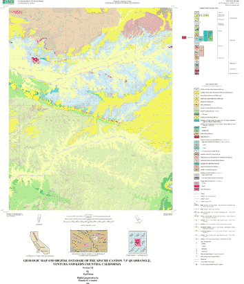
The digital geologic map database for the Apache Canyon quadrangle has been created as a general-purpose data set that is applicable to other land-related investigations in the earth and biological sciences. The Apache Canyon database is not suitable for site-specific geologic evaluations at scales greater than 1:24,000 (1 in = 2,000 ft).


How was the data set created?

  1. From what previous works were the data drawn?
  2. How were the data generated, processed, and modified?
    Date: 1997 (process 1 of 5)
    Field mapping and aerial photograph interpretation; iterative process (Paul Stone).
    Date: 2000 (process 2 of 5)
    Scribing of geologic linework (F.K. Miller).
    Date: 2000 (process 3 of 5)
    The geologic map information was scanned (initial raster scan in MS-DOS TIF format, 1200 dots per inch) from a clear-film, right-reading, 0.007 mil thickness, base-stable blackline positive (made by contact photograph from the scribeguide) of the geologic map at 1:24,000 scale. The auto-vectorized, non-attributed scan was prepared by Optronics Specialty Company, Inc. and converted to an ARC/INFO coverage using standard ARC/INFO commands. Registration and transformation were subsequently completed (P.M. Cossette).
    Geologic lines and polygons are represented in the geology coverage. Geologic points such as attitudes were digitized into a separate geologic points coverage using a Mayline Futur-Matic digitizing table (P.M. Cossette).
    Lines, points, and polygons were edited and attributed using standard ARC/INFO commands. Digitizing and editing artifacts significant enough to display at a scale of 1:24,000 were corrected (P.M. Cossette).
    The base map image was prepared by scanning a scale-stable clear-film of the U.S. Geological Survey, 1:24,000 Apache Canyon 7.5'quadrangle (1991) topographic map. Scanning was done using a Contex FSC-8000 DSP scanner, at a resolution of 500 dpi. For plotting purposes in order that geologic data not be obscurred or occluded by the topographic base map data, the monochromatic raster scan was converted to grid format in ARC/INFO GRID, and color reassigned. No elements of the base layer are attributed. The original scan (in GEOTIFF format) of the base map is provided for reference only (Z. Valin, K. Wheeler, and P.M. Cossette).
    Date: 19-May-2000 (process 4 of 5)
    First draft of metadata created by Pamela M. Cossette using FGDCMETA.AML ver. 1.2 05/14/98 on ARC/INFO data set /pool5/c/cossette2/pstone/ap_review/ap_geo0519_geo
    Date: 07-Sep-2000 (process 5 of 5)
    Creation of original metadata record Person who carried out this activity:
    U.S. Geological Survey
    Attn: Pamela M. Cossette
    U.S. Geological Survey
    Room 202
    West 904 Riverside Avenue
    Spokane, Washington
    USA

    509-368-3123 (voice)
    509-368-3199 (FAX)
    pcossette@usgs.gov
  3. What similar or related data should the user be aware of?
    Minor, Scott C., 1999, Preliminary geologic map of the San Guillermo Mountain quadrangle, Ventura County, California, version 1.0: U.S. Geological Survey Open-File Report USGS OFR 99-32, U.S. Geological Survey, Denver, Colorado.

    Online Links:


How reliable are the data; what problems remain in the data set?

  1. How well have the observations been checked?
    Geologic-map features in the Apache Canyon quadrangle were described according to standard field methods. Consistent with these methods, the database author has assigned standard geologic attributes to geologic lines, points, and polygons identified in the database.
    Geologic lines and points on 1:24,000 scale geologic maps are judged to meet map-accuracy standards if they are located to within +/-15 meters, relative to topographic or cultural features on the base map.
    Lines and points that meet (or may not meet) this map-accuracy standard are identified both in the digital database and on derivative geologic-map plots.
    Within the database, line and point data that are judged to meet the map-accuracy standard are denoted by the attribute code .MEE. (meets) in the appropriate data table; line and point data that may not meet the map-accuracy standard are denoted by the attribute code .MNM. (may not meet).
    On any derivative geologic-map plot, line data that are judged to meet the map-accuracy standard are denoted by solid lines; line data that may not meet the map-accuracy atandard are denoted by dashed or dotted lines. There is no cartographic device for denoting the map-accuracy for geologic-point data (eg. symbols representing bedding, foliation, lineations, etc.).
  2. How accurate are the geographic locations?
    The maximum transformation RMS error acceptable for 7.5' quadrangle transformation and data input is 0.003 (1.8 meters). Horizontal positional accuracy was checked by visual comparison of hard-copy plots with base-stable source data.
    Transformation data (initial DXF scan data format to ARC/INFO coverage) for the Apache Canyon quadrangle are as follows:
    Scale (X,Y) = (609.269,609.863)  Skew (degrees) = (-0.005)
    Rotation (degrees) = (0.000)  Translation = (-6238.780,-1419.455)
    RMS Error (input,output) = (0.000,0.281)
    
    
    Affine  X = Ax + By + C
            Y = Dx + Ey + F
      A =          609.269   B =           -0.056   C =        -6238.780
      D =            0.002   E =          609.863   F =        -1419.455


  3. How accurate are the heights or depths?
  4. Where are the gaps in the data? What is missing?
    The geologic map and digital database of the Apache Canyon 7.5' quadrangle contain new data that have been subjected to rigorous review and are a substantially complete representation of the current state of knowledge concerning the geology of the quadrangle.
  5. How consistent are the relationships among the observations, including topology?
    Polygon and chain-node topology present.
    The areal extent of the map is represented digitally by an appropriately projected (Polyconic projection), mathematically generated box. Consequently, polygons intersecting the lines that comprise the map boundary are closed by that boundary. Polygons internal to the map boundary are completely enclosed by line segments which are themselves a set of sequentially numbered coordinate pairs. Point data are represented by coordinate pairs.


How can someone get a copy of the data set?

Are there legal restrictions on access or use of the data?
Access_Constraints: None
Use_Constraints:
The Apache Canyon 7.5' geologic-map database should be used to evaluate and understand the geologic character of the Apache Canyon quadrangle as a whole. The data should not be used for purposes of site-specific land-use planning or site-specific geologic evaluations. The database is sufficiently detailed to identify and characterize many actual and potential geologic hazards represented by faults and landslides. However, it is not sufficiently detailed for site-specific determinations or evaluations of those features. Faults shown do not take the place of fault-rupture hazard zones designated by the California State Geologist (see Hart, 1988).
Use of the Apache Canyon geologic-map database should not violate the spatial resolution of the data. Although the digital form of the data removes the constraint imposed by the scale of any derivative maps, the detail and accuracy issues inherent in map scale limitations are also present in the digital data. The fact that this database was edited at a scale of 1:24,000 means that higher-resolution data generally are not present in the dataset. Plotting at scales larger than 1:24,000 will not yield greater, real detail, although it may reveal fine-scale irregularities beyond the intended resolution of the database. Similarly, although higher-resolution data is incorporated at a few places, the resolution of the combined output will be limited by the lower-resolution data.
This report is preliminary and has not been reviewed for conformity with U.S. Geological Survey editorial standards or with the North American Stratigraphic Code. Any use of trade, product, or firm names is for descriptive purposes only and does not imply endorsement by the U.S. Government.
Hart, E. W., 1988, Fault-rupture zones in California; Alquist-Priolo Special Studies Zones Act of 1972 with index to special studies zones maps: California Division of Mines and Geology Special Publication 42

  1. Who distributes the data set? (Distributor 1 of 1)
    U.S. Geological Survey Information Services
    Box 25286 Denver Federal Center
    Denver, CO
    USA

    303-202-4700 (voice)
    303-202-4693 (FAX)
  2. What's the catalog number I need to order this data set? USGS OFR 2000-359
  3. What legal disclaimers am I supposed to read?
    The U.S. Geological Survey (USGS) provides these geographic data "as is." The USGS makes no guarantee or warranty concerning the accuracy of information contained in the geographic data. The USGS further makes no warranties, either expressed or implied as to any other matter whatsoever, including, without limitation, the condition of the product, or its fitness for any particular purpose. The burden for determining fitness for use lies entirely with the user. Although these data have been processed successfully on computers at the USGS, no warranty, expressed or implied, is made by the USGS regarding the use of these data on any other system, nor does the fact of distribution constitute or imply any such warranty.
    In no event shall the USGS have any liability whatsoever for payment of any consequential, incidental, indirect, special, or tort damages of any kind, including, but not limited to, any loss of profits arising out of use of or reliance on the geographic data or arising out of the delivery, installation, operation, or support by USGS.
    This digital, geologic map database of the Apache Canyon 7.5'quadrangle, 1:24,000 map-scale, and any derivative maps thereof, is not meant to be used or displayed at any scale larger than 1:24,000 (e.g., 1:12,000).
  4. How can I download or order the data?
    • Availability in digital form:
      Data format: Contacts, fault traces, geologic units, and structural attitude measurements in format ARCE (version 7.x)
      Network links: http://pubs.usgs.gov/of/2000/0359/apache.tar.gz
    • Cost to order the data:

Who wrote the metadata?

Dates:
Last modified: 05-Feb-2016
Metadata author:
Peter N Schweitzer
USGS Midwest Area
Collection manager, USGS Geoscience Data Clearinghouse, http://geo-nsdi.er.usgs.gov/
Mail Stop 954
12201 Sunrise Valley Dr
Reston, VA
USA

703-648-6533 (voice)
703-648-6252 (FAX)
pschweitzer@usgs.gov
Metadata standard:
FGDC Content Standards for Digital Geospatial Metadata (FGDC-STD-001-1998)

This page is <https://geo-nsdi.er.usgs.gov/metadata/open-file/00-359/metadata.faq.html>
Generated by mp version 2.9.48 on Tue Jul 03 20:05:25 2018