Citation:
Citation_Information:
Originator: George H. Billingsley
Originator: Debra L. Block
Originator: Tracey J. Felger
Publication_Date: 2002
Title:
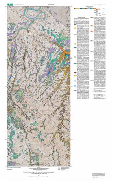
Surficial Geologic Map of The Loop and Druid Arch Quadrangles,
Canyonlands National Park, Utah
Edition: Version 1.0
Geospatial_Data_Presentation_Form: map
Series_Information:
Series_Name: U.S. Geological Survey Miscellaneous Field Studies Map
Issue_Identification: MF-2411
Publication_Information:
Publication_Place: Flagstaff, AZ
Publisher: U.S. Geological Survey
Online_Linkage: http://pubs.usgs.gov/mf/2002/2411/
Description:
Abstract:
This geologic map is a product of a cooperative project between the
U.S. Geological Survey and the U.S. National Park Service to provide
geologic information about this part of Canyonlands National Park, Utah.
This digital map database contains bedrock data from previously published
data that has been modified by the author. New mapping of the surficial
deposits represents the general distribution of surficial deposits of the
Druid Arch and The Loop 7.5-minute quadrangles.
Purpose:
The geologic data presented is intended to provide additional information
to park resource managers of Canyonlands National Park to help better
understand and implement range management practices, biological studies,
archaeological programs, and visitor interpretive information systems.
Supplemental_Information:
Use of multiple deposit labels for a polygon. Surficial geologic units may
exist as thin (< 2m) veneers over older units. In areas where this
relationship is common the unit designators are shown on the map as being
separated by a slash (/). The younger, or overlying, unit is indicated
first. Thus, Qed/Qes indicates an area where a veneer of sand dune
deposits overlies sand sheet deposits. Not all composite units are shown
on the map or in the database.
Time_Period_of_Content:
Time_Period_Information:
Single_Date/Time:
Calendar_Date: 2002
Currentness_Reference: Publication date
Status:
Progress: Complete
Maintenance_and_Update_Frequency: As Needed
Spatial_Domain:
Bounding_Coordinates:
West_Bounding_Coordinate: -109.87882988
East_Bounding_Coordinate: -109.74573
North_Bounding_Coordinate: 38.25126408
South_Bounding_Coordinate: 37.99873863
Keywords:
Theme:
Theme_Keyword_Thesaurus: USGS Thesaurus
Theme_Keyword: geology
Theme_Keyword: geologic maps
Theme_Keyword: surficial geologic units
Theme_Keyword: unconsolidated deposits
Theme_Keyword: geospatial datasets
Theme:
Theme_Keyword_Thesaurus: ISO 19115 Topic Categories
Theme_Keyword: geoscientificInformation
Place:
Place_Keyword_Thesaurus: none
Place_Keyword: Canyonlands National Park
Place_Keyword: Utah
Place_Keyword: Druid Arch 7.5-minute quadrangle
Place_Keyword: The Loop 7.5-minute quadrangle
Place:
Place_Keyword_Thesaurus: Augmented FIPS 10-4 and FIPS 6-4
Place_Keyword: f49037 = San Juan
Access_Constraints: none
Use_Constraints:
Spatial Resolution. Use of this digital geologic map should not violate
the spatial resolution of the data. This geologic map and database was
developed using digital orthophotograph quadrangles (DOQs)as a base. DOQs
have a pixel resolution of 1 or 2 m and are accurate to a scale of 1:24,000
(1 in = 2,000 ft). Any enlargement beyond 1:24,000 exceeds the spatial
resolution of the geologic data and should not be used in lieu of a more
detailed site-specific geologic evaluation. Similarly, the digital
topographic base map is derived from the U.S. Geological Survey, 1:24,000-
scale Druid Arch and The Loop 7.5 minute quadrangles; any enlargement beyond
1:24,000 exceeds the spatial resolution of the topographic data. Plotting
or viewing of the data at scales larger than 1:24,000 will not yield greater
real detail, although it may reveal fine-scale irregularities below the
intended resolution of the database.
Point_of_Contact:
Contact_Information:
Contact_Person_Primary:
Contact_Person: George H. Billingsley
Contact_Organization: U.S. Geological Survey
Contact_Position: Geologist
Contact_Address:
Address_Type: mailing and physical address
Address: 2255 N. Gemini Dr.
City: Flagstaff
State_or_Province: AZ
Postal_Code: 86001
Country: USA
Contact_Voice_Telephone: 1-928-556-7198
Contact_Facsimile_Telephone: 1-928-556-7169
Contact_Electronic_Mail_Address: gbillingsley@usgs.gov
Browse_Graphic:
Browse_Graphic:
Data_Set_Credit:
This database was prepared by George Billingsley, Debra Block, and
Tracey Felger. Technical review was provided by Harland Goldstein
and Fred Peterson. Digital review was provided by Scott Graham.
Native_Data_Set_Environment:
Windows_NT, 5.0, Intel
ARC/INFO version 8.1.2
Adobe Illustrator 9.0
Cross_Reference:
Citation_Information:
Originator: P.W. Huntoon
Originator: G.H. Billingsley
Originator: W.J. Breed
Publication_Date: 1982
Title: Geologic map of Canyonlands National Park and vicinity
Geospatial_Data_Presentation_Form: map
Publication_Information:
Publication_Place: Moab, Utah
Publisher: Canyonlands Natural History Association