Online Links:
| Value | Definition |
|---|---|
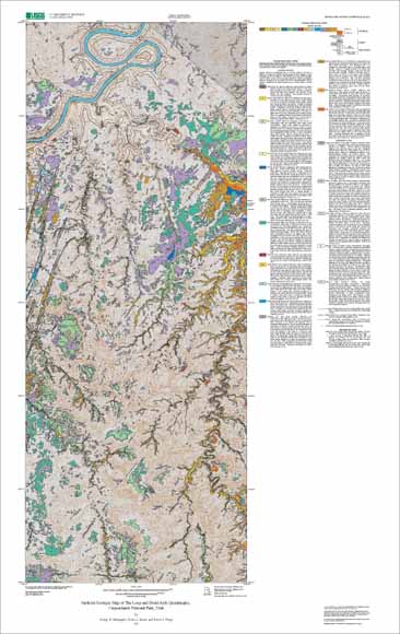
| PPe | Elephant Canyon Formation (Upper Pennsylvanian) |
| PPh | Honaker Trail Formation (Middle and Upper Pennsylvanian) |
| Pc | Cedar Mesa Sandstone (Permian) |
| Pcu | Cutler Formation/Cedar Mesa Sandstone, undifferentiated (Permian) |
| Po | Organ Rock Shale |
| Qae | Alluvium and sand sheet deposits (Holocene and Pleistocene?) |
| Qaf | Artificial fill and quarries (Holocene) |
| Qal | Alluvial deposits (Holocene and Pleistocene?) |
| Qed | Sand dune deposits (Holocene) |
| Qes | Sand sheet deposits (Holocene) |
| Qf1 | Young alluvial fan deposits (Holocene) |
| Qf2 | Young intermediate alluvial fan deposits (Holocene) |
| Qfp | Floodplain deposits (Holocene) |
| Qp | Ponded deposits (Holocene) |
| Qr | Colorado River terrace deposits (Holocene) |
| Qrf | Rock fall debris (Holocene) |
| Qs | Stream-channel alluvium (Holocene) |
| Qt1 | Young alluvial terrace deposits (Holocene) |
| Qt2 | Intermediate alluvial terrace deposits (Holocene and Pleistocene?) |
| Qt3 | Old alluvial terrace deposits (Pleistocene) |
| water | water |
| Value | Definition |
|---|---|
| contact_certain | Boundary between two mapped units that retains the original depositional or intrusive relationship. The contact has been observed or is closely constrained, so it is well located as described in Positional_Accuracy. |
| fault_certain | Structural boundary between mapped units or structural discontinuity within a mapped unit that has experienced relative offset between the rock bodies on either side of the fault. The fault has been observed or is closely constrained, so it is well located as described in Positional_Accuracy. |
| fault_concealed | Structural boundary between mapped units or structural discontinuity within a mapped unit that has experienced relative offset between the rock bodies on either side of the fault. The fault is obscured by overlying mapped units, so it is not well located as described in Positional_Accuracy, but the location is constrained to be within about 95 meters on the ground. |
| facies_change | The lateral and vertical transition zone in the lithologic characteristics of contemporaneous deposits. |
| map_boundary | Edge of the mapped area. Used primarily to bound polygons at the edge of the map database. |
| Value | Definition |
|---|---|
| fault_ball_fill | Arcmarker attached to an arc describing the nature of displacement along a fault. Side of arc with bar and ball is the side with downthrown displacement. |
| xx | Placeholder - no arcmarker is drawn on arc. |
| Value | Definition |
|---|---|
| sinkhole | Observed location of an enclosed depression or cave. |
This database was prepared by George Billingsley, Debra Block, and Tracey Felger. Technical review was provided by Harland Goldstein and Fred Peterson. Digital review was provided by Scott Graham.
The geologic data presented is intended to provide additional information to park resource managers of Canyonlands National Park to help better understand and implement range management practices, biological studies, archaeological programs, and visitor interpretive information systems.
Are there legal restrictions on access or use of the data?Access_Constraints: none
Use_Constraints:Spatial Resolution. Use of this digital geologic map should not violate the spatial resolution of the data. This geologic map and database was developed using digital orthophotograph quadrangles (DOQs)as a base. DOQs have a pixel resolution of 1 or 2 m and are accurate to a scale of 1:24,000 (1 in = 2,000 ft). Any enlargement beyond 1:24,000 exceeds the spatial resolution of the geologic data and should not be used in lieu of a more detailed site-specific geologic evaluation. Similarly, the digital topographic base map is derived from the U.S. Geological Survey, 1:24,000- scale Druid Arch and The Loop 7.5 minute quadrangles; any enlargement beyond 1:24,000 exceeds the spatial resolution of the topographic data. Plotting or viewing of the data at scales larger than 1:24,000 will not yield greater real detail, although it may reveal fine-scale irregularities below the intended resolution of the database.
The U.S. Geological Survey (USGS) provides these geographic data "as is." The USGS makes no guarantee or warranty concerning the accuracy of information contained in the Geographic: data. The USGS further makes no warranties, either expressed or implied as to any other matter whatsoever, including, without limitation, the condition of the product, or its fitness for any particular purpose. The burden for determining fitness for use lies entirely with the user. Although these data have been processed successfully on computers at the USGS, no warranty, expressed or implied, is made by the USGS regarding the use of these data on any other system, nor does the fact of distribution constitute or imply any such warranty.
In no event shall the USGS have any liability whatsoever for payment of any consequential, incidental, indirect, special, or tort damages of any kind, including, but not limited to, any loss of profits arising out of use of or reliance on the Geographic: data or arising out of delivery, installation, operation, or support by USGS.
| Data format: | Bedrock and surficial geologic units in format Shapefile (version 1.0) Size: 5.2 |
|---|---|
| Network links: |
http://pubs.usgs.gov/mf/2002/2411/Mf2411_shapefiles.zip |