Attribute_Accuracy_Report:
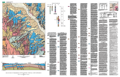
Original data were drawn on two 1:24,000-scale mylar greenlines by the authors. D.J. Koning was responsible for mapping bedrock and surficial deposits south of the Jemez River; S.F. Personius was responsible for mapping bedrock and surficial deposits north of the Jemez River, surficial deposits adjacent to the Jemez River, and geologic compilation of the quadrangle.
Attributes have been checked by both the author and reviewers for accuracy and completeness.
Polygon and chain-node topology present.
Map elements were visually checked for overshoots, undershoots, duplicate features, polygon attributes, and other errors. Automated (ARC/INFO) routines were also used
to check the databases for polygon label errors, line or point attribution errors, sliver polygons, dangling arcs, intersection errors, and projection information.
The map was reviewed by other geologists for consistency with basic geologic principles and general conformity to USGS mapping standards.
Some areas of the southeastern part of the map on lands of
Santo Ana Pueblo were not visited or field checked.
Horizontal_Positional_Accuracy:
Horizontal_Positional_Accuracy_Report:
Lines and point locations were primarily mapped by photo-interpretation of field-marked 1:20,000-scale black and white, 1:36,000 color, and 1:40,000-scale color-infrared aerial photographs using a PG-2 photogrammetric plotter that rectified the position and transferred locations to a 1:24,000-scale base map.
Process_Step:
Process_Description: Field mapping by the authors.
Process_Date: 1999
Process_Step:
Process_Description:
Compilation with stereo aerial photography on PG-2 plotter by the authors.
Process_Date: 1999
Process_Step:
Process_Description:
Cole combined the geologic features mapped separately by Personius and Koning and created punch-registered mylar sheets at 1:24,000-scale to facilitate digitization. One mylar sheet contained all geologic contact lines (traced from the geologists' original greenlines), a second contained all fault features, and a third contained all fold axes, tephra beds, and related linear features
that do not affect polygons. Registration marks were positioned on the mylar sheets by inspection at 2.5-minute intervals to facilitate geo-registering and combining the scanned/digitized files for the map database.
Process_Date: 2001
Process_Contact:
Contact_Information:
Contact_Person_Primary:
Contact_Person: James Channing Cole
Contact_Organization: U.S. Geological Survey, CR
Contact_Address:
Address_Type: mailing address
Address:
Mail Stop 913
Box 25046, Denver Federal Center
City: Denver
State_or_Province: CO
Postal_Code: 80225-0046
Country: USA
Contact_Voice_Telephone: 303-236-1417
Contact_Facsimile_Telephone: 303-236-0214
Contact_Electronic_Mail_Address: [email protected]
Process_Step:
Process_Description:
Polygons, lines, and points representing geologic features and data points were digitized from scale-stable compilation materials using 'heads up digitizing'
in ArcInfo to create geology, line, and point coverages. Polygon topology was built in the geology coverage.
Process_Date: 2001
Process_Step:
Process_Description:
Text map unit descriptors were added to the .AAT and .PAT
database files for each coverage.
Process_Date: 2001
Process_Step:
Process_Description:
Draft check plots of the geologic map and explanation were created and submitted for peer review. Geologists reviewed the plots for conformity with U.S. Geological Survey editorial standards and stratigraphic nomenclature. Revisions were made to the geospatial database as needed.
Process_Date: 2001
Process_Step:
Process_Description:
First draft of metadata created by Amy Zoller using
FGDCMETA.AML ver. 1.32 01/11/99 on ARC/INFO data set
/data9/azoller/bernalillo/finalcov/bernalillo
Process_Date: 20020301
Process_Step:
Process_Description:
The geospatial database files and metadata were quality
checked for completeness and consistency.
Process_Date: 2002
Process_Step:
Process_Description:
The database files, metadata, and check plots were edited by the USGS Central Publications Group, and revisions made to the geospatial database as needed.
Process_Date: 2002
Process_Step:
Process_Description:
Final preparation of the geospatial database for distribution, and preparation of map-on-demand files and metadata.
Process_Date: 2002
Process_Step:
Process_Description:
Map-on-demand, PDF layouts, and database updated to correct information about faults in sec. 4 and 9, T. 14 N., R. 3 E., to correct a dip value in sec. 10, T. 14 N., R. 2 E., and to show additional information about fault displacement in northeast corner of map area (version 1.1)
Process_Date: 20030225
Process_Step:
Process_Description: Creation of original metadata record
Process_Date: 20020301
Process_Contact:
Contact_Information:
Contact_Organization_Primary:
Contact_Organization: U.S. Geological Survey
Contact_Person: Amy L. Zoller
Contact_Address:
Address_Type: mailing and physical address
Address: MS 980, Box 25046, Denver Federal Center
City: Denver
State_or_Province: CO
Postal_Code: 80225-0046
Country: USA
Contact_Voice_Telephone: 303-236-7648
Contact_Electronic_Mail_Address: [email protected]