bernalillo:    Geologic units, tephra beds
berngeoline:   Geologic contacts, faults, anticlines, synclines
bernaline:     Aeromagnetic anomalies, cross-section lines
bernapoint:    Strike and dip symbols, fault dips, paleocurrent vectors, sample points
Although this metadata file is intended to document the data set in nonproprietary form, as well as in ArcInfo format, this metadata file may include some ArcInfo-specific terminology.
Online Links:
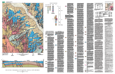
------------------------------
COVERAGE NAME:  bernalillo
------------------------------
DATABASE STRUCTURE OF BERNALILLO.PAT:

COLUMN   ITEM NAME        WIDTH OUTPUT  TYPE N.DEC  ALTERNATE NAME
 1  AREA                   8    18     F      5
 9  PERIMETER              8    18     F      5
17  BERNALILLO#            4     5     B      -    B
21  BERNALILLO-ID          4     5     B      -
25  SYMBOL                 4     4     I      -    S
29  UNIT                  15    15     C      -
44  DESCRIPTION          100   100     C      -    D

ATTRIBUTE NAMES:  SYMBOL; UNIT; DESCRIPTION.

DESCRIPTIONS OF ATTRIBUTE NAMES:
--SYMBOL:        Number given to geological map unit representing a value of color used from shadeset "color524.shd".
--UNIT:          Label given to polygons representing name of geological entities.
--DESCRIPTION:   Brief geological explanation of unit.

ITEM VALUES FOR 'UNIT' AND 'DESCRIPTION'
UNIT           DESCRIPTION
------------------------------
Qaj2       Alluvium 2 of Jemez River (middle Pleistocene)
Qaj3       Alluvium 3 of Jemez River (middle Pleistocene)
Qaj4       Alluvium 4 of Jemez River (middle Pleistocene)
Qaj5       Alluvium 5 of Jemez River (upper to middle(?) Pleistocene)
Qaj6a      Alluvium 6a of Jemez River (Holocene)
Qaj6b      Alluvium 6b of Jemez River (Holocene)
Qalh       Active channel alluvium (historic)
Qalo       Older arroyo alluvium (Holocene to lower(?) Pleistocene)
Qaly       Younger arroyo alluvium (Holocene)
Qesd       Active sand dunes (historic)
Qeso       Older eolian sand (Holocene to middle(?) Pleistocene)
Qeso/Qalo  Older eolian sand over older arroyo alluvium (Holocene to middle(?) Pleistocene)
Qesy       Younger eolian sand (Holocene)
Qesy/Qaj6a Younger eolian sand over alluvium 6a of Jemez River (Holocene)
Qesy/Qalo  Younger eolian sand over older arroyo alluvium (Holocene)
Qesy/Qaly  Younger eolian sand over younger arroyo alluvium (Holocene)
Qf         Artificial fill (Historic)
Tob        Arroyo Ojito Formation, Loma Barbon Member (Pliocene to upper Miocene)
Toc        Arroyo Ojito Formation, Ceja Member (Pliocene)
Tocf       Arroyo Ojito Formation, fault-related rocks in Ceja Member (Pliocene)
Ton        Arroyo Ojito Formation, Navajo Draw Member (upper Miocene)
Tonl       Arroyo Ojito Formation, lower part of Navajo Draw Member (upper Miocene)
Tonlr      Arroyo Ojito Formation, red zone in lower part of Navajo Draw Member (upper Miocene)
Tonm       Arroyo Ojito Formation, middle part of Navajo Draw Member (upper Miocene)
Tonu       Arroyo Ojito Formation, upper part of Navajo Draw Member (upper Miocene)
Tsfu       Santa Fe Group, undivided (Miocene)
Tzcc       Zia Formation, Cerro Conejo Member (upper and middle Miocene)
Tzccc      Zia Formation, cemented Cerro Conejo Member (upper and middle Miocene)
Tzcci      Zia Formation, interbedded upper part of Cerro Conejo Member (upper Miocene)

DATABASE STRUCTURE OF BERNALILLO.AAT:

COLUMN   ITEM NAME        WIDTH OUTPUT  TYPE N.DEC  ALTERNATE NAME
 1  FNODE#                 4     5     B      -
 5  TNODE#                 4     5     B      -
 9  LPOLY#                 4     5     B      -
13  RPOLY#                 4     5     B      -
17  LENGTH                 8    18     F      5
25  BERNALILLO#            4     5     B      -
29  BERNALILLO-ID          4     5     B      -
33  SYMBOL                 3     3     I      -    S
36  LINESET               25    25     C      -
61  DESCRIPTION           50    50     C      -    D

ATTRIBUTE NAMES:  SYMBOL; LINESET; DESCRIPTION.

DESCRIPTIONS OF ATTRIBUTE NAMES:
--SYMBOL:        Numbers given to lines representing line symbol used from specified lineset.
--LINESET:       Arc/Info symbolset corresponding line symbol with given symbol number.
--DESCRIPTION:   Brief geological explanation of type of line.

ITEM VALUES FOR 'SYMBOL', 'LINESET', AND 'DESCRIPTION':
SYMBOL  LINESET         DESCRIPTION
--------------------------------------------------------
  1  geol_sfo.lin       contact-certain
  3  geol_sfo.lin       contact-approximately located
  3  geol_sfo.lin       contact-approximately located,queried
 51  geol_sfo.lin       fault with known sense of displacement-certain
 52  geoscamp1.lin      fault with unknown sense of displacement-approximately located
 53  geoscamp1.lin      fault with unknown sense of displacement-concealed
 54  geoscamp1.lin      fault with known sense of displacement-approximately located,queried
 60  geol_sfo.lin       anticline-certain
 92  geol_sfo.lin       syncline-certain
185  geol_sfo.lin       fault with known sense of displacement-approximately located
186  geol_sfo.lin       fault with known sense of displacement-concealed
186  geol_sfo.lin       fault with known sense of displacement-concealed,queried
210  geoscamp1.lin      fault with unknown sense of displacement-certain
218  geol_sfo.lin       tephra deposit

--------------------------
COVERAGE NAME:  bernaline
--------------------------
DATABASE STRUCTURE OF BERNALINE.AAT:

COLUMN   ITEM NAME        WIDTH OUTPUT  TYPE N.DEC  ALTERNATE NAME     INDEXED?
 1  FNODE#                 4     5     B      -                        -
 5  TNODE#                 4     5     B      -                        -
 9  LPOLY#                 4     5     B      -                        -
13  RPOLY#                 4     5     B      -                        -
17  LENGTH                 8    18     F      5                        -
25  BERNALINE#             4     5     B      -                        -
29  BERNALINE-ID           4     5     B      -                        -
33  SYMBOL                 3     3     I      -                        -
36  DESCRIPTION           25    25     C      -                        -

ATTRIBUTE NAMES:  SYMBOL; DESCRIPTION.

DESCRIPTIONS OF ATTRIBUTE NAMES:
--SYMBOL:        Numbers given to lines representing line symbol used from specified lineset.
--DESCRIPTION:   Brief geological explanation of type of line.

ITEM VALUES FOR 'SYMBOL' AND 'DESCRIPTION':
DESCRIPTION            SYMBOL
-------------------------------------------
cross-section A - A'          1
aeromagnetic anomaly   164

---------------------------
COVERAGE NAME:  bernapoint
---------------------------
DATABASE STRUCTURE OF BERNAPOINT.PAT:

BERNAPOINT.PAT
COLUMN   ITEM NAME        WIDTH OUTPUT  TYPE N.DEC  ALTERNATE NAME     INDEXED?
  1  AREA                   4    12     F      3                        -
  5  PERIMETER              4    12     F      3                        -
  9  BERNAPOINT#            4     5     B      -                        -
 13  BERNAPOINT-ID          4     5     B      -                        -
 17  DESCRIPTION          100   100     C      -    D                   -
117  SYMBOL                 4     4     I      -    S                   -
121  DIP                    4     4     I      -    DI                  -
125  STRIKE                 4     4     I      -    ST                  -
129  TEXT                 100   100     C      -

ATTRIBUTE NAMES:  STRIKE; DIP; DESCRIPTION; SYMBOL; TEXT.

DESCRIPTIONS OF ATTRIBUTE NAMES:
--STRIKE:       Compass direction of bedding trend, in degrees.
--DIP:          Angle of bedding dip, in degrees from horizontal.
--DESCRIPTION:  Brief geologic explanation of point type.
--SYMBOL:       Numerical value given to each point from Arc/Info symbolset geoscamp2.mrk.
--TEXT:         Sample point map labels indicating name or date of sample taken from point locality.

ITEM VALUES FOR 'SYMBOL', 'TEXT', AND 'DESCRIPTION'.
SYMBOL TEXT                  DESCRIPTION
---------------------------------------------------------------------------------------------------------------------------------------
  0    A                    point A of cross-section
  0    A'                   point A prime of cross-section         -
  2                         inclined bedding-showing strike and dip
130                         paleocurrent vector
233    8/26/97-1            sample point
233    MRGB-17-BNW          sample point
233    MRGB-19-BN           sample point
233    Tamara # 1-Y         well location
233    M1                   sample point
233    8h                   sample point
233    11c                  sample point
233    11e                  sample point
241                         dip of fault
493                         plunge of anticline

ITEM VALUES FOR 'STRIKE':
range of values:  0 - 359

ITEM VALUES FOR 'DIP':
range of values:  0 - 90
Production of this map was funded by the National Cooperative Geologic Mapping Program.
The geology of the Bernalillo NW quadrangle was mapped as part of the USGS Middle Rio Grande Basin project to explore the geologic framework of water resources in the region.
Are there legal restrictions on access or use of the data?Access_Constraints: none
Use_Constraints:None. However, acknowledgment of the U.S. Geological survey would be appreciated in products derived from these data.
Any use of trade, product, or firm names is for descriptive purposes only and does not imply endorsement by the U.S. Government.
Although these data have been used by the U.S. Geological Survey, U.S. Department of the Interior, no warranty expressed or implied is made by the U.S. Geological Survey as to the accuracy of the data.
The act of distribution shall not constitute any such warranty, and no responsibility is assumed by the U.S. Geological Survey in the use of this data, software, or related materials.
| Data format: | Geologic units and structural features in format ARCE (version 7.1.2) Size: 2.1 |
|---|---|
| Network links: |
http://pubs.usgs.gov/mf/2002/mf-2404/mf-2404.tar.gz http://pubs.usgs.gov/mf/2002/mf-2404/mf-2404.zip |
| Data format: | Geologic units and structural features in format Shapefile (version 1.0) Size: 2.1 |
|---|---|
| Network links: |
http://pubs.usgs.gov/mf/2002/mf-2404/mf-2404.tar.gz http://pubs.usgs.gov/mf/2002/mf-2404/mf-2404.zip |