Geologic map of the Storm King Mountain quadrangle, Garfield County, Colorado

Metadata also available as - [Questions & Answers] - [Parseable text] - [XML]

Metadata:

Identification_Information:
Citation:
Citation_Information:
Originator: Bruce Bryant
Originator: Ralph R. Shroba
Originator: Anne E. Harding
Originator: Kyle E. Murray
Publication_Date: 2002
Title:
Geologic map of the Storm King Mountain quadrangle, Garfield County, Colorado
Edition: Version 1.0
Geospatial_Data_Presentation_Form: Map and GIS database
Series_Information:
Series_Name: U.S. Geological Survey Miscellaneous Field Studies Map
Issue_Identification: MF-2389
Publication_Information:
Publication_Place: Denver, Colorado
Publisher: U.S. Geological Survey
Online_Linkage: http://pubs.usgs.gov/mf/2002/mf-2389/
Description:
Abstract:
New 1:24,000-scale geologic mapping in the Storm King Mountain 7.5' quadrangle, in support of the USGS Western Colorado I-70 Corridor Cooperative Geologic Mapping Project, provides new data on the structure on the south margin of the White River uplift and the Grand Hogback and on the nature, history, and distribution of surficial geologic units.
Rocks ranging from Holocene to Proterozoic in age are shown on the map. The Canyon Creek Conglomerate, a unit presently known to only occur in this quadrangle, is interpreted to have been deposited in a very steep sided local basin formed by dissolution of Pennsylvanian evaporite late in Tertiary time. At the top of the Late Cretaceous Williams Fork Formation is a unit of sandstone, siltstone, and claystone from which Late Cretaceous palynomorphs were obtained in one locality. This interval has been mapped previously as Ohio Creek Conglomerate, but it does not fit the current interpretation of the origin of the Ohio Creek. Rocks previously mapped as Frontier Sandstone and Mowry Shale are here mapped as the lower member of the Mancos Shale and contain beds equivalent to the Juana Lopez Member of the Mancos Shale in northwestern New Mexico. The Pennsylvanian Eagle Valley Formation in this quadrangle grades into Eagle Valley Evaporite as mapped by Kirkham and others (1997) in the Glenwood Springs area.
The Storm King Mountain quadrangle spans the south margin of the White River uplift and crosses the Grand Hogback monocline into the Piceance basin. Nearly flat lying Mississippian through Cambrian sedimentary rocks capping the White River uplift are bent into gentle south dips and broken by faults at the edge of the uplift. South of these faults the beds dip moderately to steeply to the south and are locally overturned. These dips are interrupted by a structural terrace on which are superposed numerous gentle minor folds and faults. This terrace has an east-west extent similar to that of the Canyon Creek Conglomerate to the north. We interpret that the terrace formed by movement of Eagle Evaporite from below in response to dissolution and diapirism in the area underlain by the conglomerate. A low-angle normal fault dipping gently north near the north margin of the quadrangle may have formed also in response to diapirism and dissolution in the area of the Canyon Creek Conglomerate. Along the east edge of the quadrangle Miocene basalt flows are offset by faults along bedding planes in underlying south-dipping Cretaceous rocks, probably because of diapiric movement of evaporite into the Cattle Creek anticline (Kirkham and Widmann, 1997).
Steep topography and weak rocks combine to produce a variety of geologic hazards in the quadrangle.
Purpose:
Update and reinterpret earlier geologic mapping, and provide sufficient geologic information for land-use decisions.
Supplemental_Information:
Any use of trade, product, or firm names is for descriptive purposes only and does not imply endorsement by the U.S. Government.
Although this Federal Geographic Data Committee-compliant
metadata file is intended to document the data set in
nonproprietary form, as well as in ARC/INFO format, this
metadata file may include some ARC/INFO-specific terminology.
FILES INCLUDED IN THIS DATA SET:
skmpoly: polygon coverage containing geologic unit contacts,
         faults, and labels.
skmline: arc coverage containing fold axes, lines of cross-
         sections, and other linear map entities.
skmpnt:  point coverage containing strike and dip attitudes
         of bedding and foliation, and other point-data map
         entities.
Time_Period_of_Content:
Time_Period_Information:
Single_Date/Time:
Calendar_Date: 2002
Currentness_Reference: publication date

Status:
Progress: Complete
Maintenance_and_Update_Frequency: None planned

Spatial_Domain:
Bounding_Coordinates:
West_Bounding_Coordinate: -107.5
East_Bounding_Coordinate: -107.375
North_Bounding_Coordinate: 39.625
South_Bounding_Coordinate: 39.5

Keywords:
Theme:
Theme_Keyword_Thesaurus: USGS Thesaurus
Theme_Keyword: geologic maps
Theme_Keyword: unconsolidated deposits
Theme_Keyword: surficial geologic units
Theme_Keyword: geospatial datasets
Theme_Keyword: geology
Theme:
Theme_Keyword_Thesaurus: none
Theme_Keyword: geologic map
Theme_Keyword: Alluvial
Theme_Keyword: Colluvial
Theme_Keyword: Glacial
Theme_Keyword: Eolian
Theme_Keyword: Surficial
Theme:
Theme_Keyword_Thesaurus: ISO 19115 Topic Categories
Theme_Keyword: geoscientificInformation
Place:
Place_Keyword_Thesaurus: none
Place_Keyword: USA
Place_Keyword: Colorado
Place_Keyword: Garfield County
Place_Keyword: Storm King Mountain
Place:
Place_Keyword_Thesaurus: Augmented FIPS 10-4 and FIPS 6-4
Place_Keyword: f08045 = Garfield
Access_Constraints: none
Use_Constraints:
These data are intended for use at 1:24,000 scale. Acknowledgment of the USGS would be appropriate in products derived from these data. Any hardcopies utilizing these data sets shall clearly indicate their source. If the user has modified the data in any way they are obligated to describe the types of modifications they have performed on the hardcopy map. User specifically agrees not to misrepresent these data sets, nor to imply that changes were approved by the USGS or the authors of this geologic map database.
Point_of_Contact:
Contact_Information:
Contact_Person_Primary:
Contact_Person: Bruce Bryant
Contact_Organization: U.S. Geological Survey
Contact_Position: Geologist
Contact_Address:
Address_Type: mailing and physical address
Address: U.S. Geological Survey MS 913 Denver Federal Center
City: Lakewood
State_or_Province: CO
Postal_Code: 80225-0046
Country: USA
Contact_Voice_Telephone: 303-236-1234
Contact_Electronic_Mail_Address: bbryant@usgs.gov

Data_Set_Credit:
Bedrock geology mapped by Bruce Bryant, 1995-1997. Surficial geology mapped by Ralph R. Shroba, 1992-1993. Digitized by Anne E. Harding, 1997-1998. Conversion to ARC/INFO format and preparation of metadata by Kyle E. Murray, 2000-2002
Native_Data_Set_Environment: SunOS, 5.7, sun4d UNIX ARC/INFO version 8.0.2

Browse_Graphic:
Browse_Graphic_File_Name: http://pubs.usgs.gov/mf/2002/mf-2389/mf-2389.gif
Browse_Graphic_File_Description: Reduced-size image of the map sheet, 250x283 pixels, 38k bytes.
Browse_Graphic_File_Type: GIF
Browse_Graphic:
Browse_Graphic_File_Name: http://pubs.usgs.gov/mf/2002/mf-2389/mf-2389_map.pdf
Browse_Graphic_File_Description: Printable representation of map layout, 2.7 megabytes
Browse_Graphic_File_Type: PDF

Data_Quality_Information:
Attribute_Accuracy:
Attribute_Accuracy_Report:
Attributes were checked by manually comparing hardcopy plots of the digital data with the source materials. Authors and USGS map editors performed separate reviews.
Logical_Consistency_Report:
The map was released in preliminary form by Bryant and others (1998), superseding one by Fairer and others (1993) that contained incorrect contacts, faults, and rock unit identifications and lacked structural information. Unfortunately during field work for this revision about 12 percent of the quadrangle, mostly in the southwestern part, was not accessible to us; consequently geologic information for the inaccessible areas was obtained from interpretation of aerial photographs, published reports, and observations from a county road and adjacent areas.
Map elements were visually checked for overshoots, undershoots, duplicate features, polygon closure, and other errors by the authors and by the GIS technician(s) that created the digital database. Automated (ARC/INFO) routines were also used to check the databases for polygon label errors, line or point attribution errors, sliver polygons, dangling arcs, intersection errors, and projection information. Check plots of the map were reviewed by two other geologists for consistency with basic geologic principles and general conformity to USGS mapping standards.
Positional_Accuracy:
Horizontal_Positional_Accuracy:
Horizontal_Positional_Accuracy_Report:
Geologic contacts and features were plotted from field notes on a topographic mylar base map. Lines were digitized from the base map using a digitizer tablet with resolution of 0.001 inch, and most digitized positions on the map are estimated to have at least 10 m horizontal accuracy. Elevation data that are included in the database are from digital line graph data from 1:24,000-scale 7.5' quadrangles.
Lineage:
Source_Information:
Source_Citation:
Citation_Information:
Originator: Fairer, G.M.
Originator: Green, M.W.
Originator: Shroba, R.R.
Title:
Preliminary geologic map of the Storm King Mountain quadrangle, Garfield County, Colorado
Publication_Date: 1993
Series_Information:
Series_Name: U.S. Geological Survey Open-File Report
Issue_Identification: 93-320
Publication_Information:
Publication_Place: Denver, Colorado
Publisher: U.S. Geological Survey
Source_Scale_Denominator: 24000
Type_of_Source_Media: paper
Source_Time_Period_of_Content:
Time_Period_Information:
Single_Date/Time:
Calendar_Date: 1993
Source_Currentness_Reference: publication date
Source_Citation_Abbreviation: Fairer and others (1993)
Source_Contribution: preliminary geologic information

Source_Information:
Source_Citation:
Citation_Information:
Originator: Bryant, Bruce
Originator: Shroba, R.R.
Originator: Harding, A.E.
Publication_Date: 1998
Title:
Revised preliminary geologic map of the Storm King Mountain quadrangle, Garfield County, Colorado
Geospatial_Data_Presentation_Form: map
Series_Information:
Series_Name: U.S. Geological Survey Open-File Report
Issue_Identification: 98-472
Publication_Information:
Publication_Place: Denver, Colorado
Publisher: U.S. Geological Survey
Source_Scale_Denominator: 24000
Type_of_Source_Media: paper
Source_Time_Period_of_Content:
Time_Period_Information:
Single_Date/Time:
Calendar_Date: 1998
Source_Currentness_Reference: publication date
Source_Citation_Abbreviation: Bryant and others (1998)
Source_Contribution: Preliminary revision of the map

Process_Step:
Process_Description:
Field mapping and air photo interpretation culminating in a preliminary revision of the map
Source_Used_Citation_Abbreviation: Fairer and others (1993)
Process_Date: 1998
Source_Produced_Citation_Abbreviation: Bryant and others (1998)

Process_Step:
Process_Description:
The geologic database was digitized using the GSMCAD public domain program (USGS Open-File Report 96-007).
Process_Date: 1997-1998

Process_Step:
Process_Description:
The database was exported from GSMCAD to Arc GENERATE ASCII files.
Process_Date: 2000

Process_Step:
Process_Description:
The gsmarc.aml program (distributed with GSMCAD) was used in ArcInfo to convert the GENERATE files to Arc coverages and build polygons.
Process_Date: 2000

Process_Step:
Process_Description:
First draft of metadata created by Kyle E. Murray using FGDCMETA.AML ver. 1.32 01/11/99 on ArcInfo data set /data9/kmurray2/stormking/skm24k
Process_Date: 20000111

Process_Step:
Process_Description:
USGS Topographic Base Map data was scanned at 400 dots per inch (dpi), processed in Adobe Photoshop as a bitmap-grayscale image, and then georegistered using ArcInfo software.
Process_Date: 2001

Process_Step:
Process_Description:
Attributes of ArcInfo coverages were revised to comply with the Public Review Draft - Digital Cartographic Standard for Geologic Map Symbolization published in April 2000 by the Federal Geographic Data Committee.
Process_Date: 2001

Process_Step:
Process_Description:
Checkplots of the coverages were printed and checked against source materials for accuracy and completeness. The database information was checked visually and digitally using various routines in ArcInfo for accuracy and consistency.
Process_Date: 2001

Process_Step:
Process_Description: Creation of original metadata record
Process_Date: 20090819
Process_Contact:
Contact_Information:
Contact_Organization_Primary:
Contact_Organization: U.S. Geological Survey
Contact_Person: Schumann, R. Randall
Contact_Address:
Address_Type: mailing and physical address
Address: MS 913, USGS Box 25046, Denver Federal Center
City: Denver
State_or_Province: CO
Postal_Code: 80225-0046
Country: USA
Contact_Voice_Telephone: 303-236-1525
Contact_Electronic_Mail_Address: rschumann@usgs.gov
Spatial_Data_Organization_Information:
Direct_Spatial_Reference_Method: Vector

Point_and_Vector_Object_Information:
SDTS_Terms_Description:
SDTS_Point_and_Vector_Object_Type: Point
SDTS_Terms_Description:
SDTS_Point_and_Vector_Object_Type: String
SDTS_Terms_Description:
SDTS_Point_and_Vector_Object_Type: GT-polygon composed of chains

Spatial_Reference_Information:
Horizontal_Coordinate_System_Definition:
Planar:
Grid_Coordinate_System:
Grid_Coordinate_System_Name: Universal Transverse Mercator
Universal_Transverse_Mercator:
UTM_Zone_Number: 13
Transverse_Mercator:
Longitude_of_Central_Meridian: -105.0
Scale_Factor_at_Central_Meridian: 0.9996
Latitude_of_Projection_Origin: 0
False_Easting: 500000
False_Northing: 0
Planar_Coordinate_Information:
Planar_Coordinate_Encoding_Method: coordinate pair
Coordinate_Representation:
Abscissa_Resolution: 1.4166052
Ordinate_Resolution: 1.4166052
Planar_Distance_Units: Meters
Geodetic_Model:
Horizontal_Datum_Name: North American Datum of 1927
Ellipsoid_Name: Clarke 1866
Semi-major_Axis: 6378206.4
Denominator_of_Flattening_Ratio: 294.98

Entity_and_Attribute_Information:
Detailed_Description:
Entity_Type:
Entity_Type_Label: POLYGONGONAL FEATURES OF THE GEOLOGIC DATA
Entity_Type_Definition: Geologic units and other land-cover polygonal features.
Entity_Type_Definition_Source: USGS Central Earth Surface Processes Team convention
Attribute:
Attribute_Label: SYMBOL
Attribute_Definition:
Integer index of the fill color for this polygon. The index indicates an element of the shade set color524.shd.
Attribute_Definition_Source: USGS Central Earth Surface Processes Team convention
Attribute_Domain_Values:
Codeset_Domain:
Codeset_Name: Shadeset from supplied file
Codeset_Source: color524.shd
Attribute:
Attribute_Label: LABEL
Attribute_Definition:
Map unit label. This is a character field of width 17. The typeface used is fnt027, included with this package. Some geologic map units are labeled using symbols that are not represented in standard type faces, such as the symbols for the Cambrian, Pennsylvanian, and Triassic periods. The font fnt027, included with the ArcInfo export files in this database package, is used to draw these symbols.
Attribute_Definition_Source: USGS Central Earth Surface Processes Team convention
Attribute_Domain_Values:
Attribute:
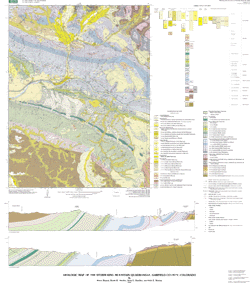
Attribute_Label: TEXT
Attribute_Definition:
Map-unit label expressed in the nearest ASCII equivalent of the unit label that is actually shown on the printed map sheet. Some geologic unit labels contain symbols that cannot be represented using ASCII, such as the symbols for the Cambrian, Pennsylvanian, and Triassic periods. The proper symbols are contained within the font file fnt027.
Attribute_Definition_Source: USGS Central Earth Surface Processes Team convention
Attribute_Domain_Values:
Enumerated_Domain:
Enumerated_Domain_Value: Qsw
Enumerated_Domain_Value_Definition: Sheetwash deposits
Attribute_Domain_Values:
Enumerated_Domain:
Enumerated_Domain_Value: Qto
Enumerated_Domain_Value_Definition: Older terrace alluvium
Attribute_Domain_Values:
Enumerated_Domain:
Enumerated_Domain_Value: af
Enumerated_Domain_Value_Definition: artificial fill
Attribute_Domain_Values:
Enumerated_Domain:
Enumerated_Domain_Value: Qta
Enumerated_Domain_Value_Definition: Talus deposits
Attribute_Domain_Values:
Enumerated_Domain:
Enumerated_Domain_Value: Qlo
Enumerated_Domain_Value_Definition: Loess
Attribute_Domain_Values:
Enumerated_Domain:
Enumerated_Domain_Value: Qc
Enumerated_Domain_Value_Definition: Colluvium
Attribute_Domain_Values:
Enumerated_Domain:
Enumerated_Domain_Value: Qti
Enumerated_Domain_Value_Definition: Till
Attribute_Domain_Values:
Enumerated_Domain:
Enumerated_Domain_Value: Qtt
Enumerated_Domain_Value_Definition: Oldest terrace alluvium
Attribute_Domain_Values:
Enumerated_Domain:
Enumerated_Domain_Value: Qdy
Enumerated_Domain_Value_Definition: Younger debris-flow deposits
Attribute_Domain_Values:
Enumerated_Domain:
Enumerated_Domain_Value: Qls
Enumerated_Domain_Value_Definition: Landslide deposits
Attribute_Domain_Values:
Enumerated_Domain:
Enumerated_Domain_Value: Kw
Enumerated_Domain_Value_Definition: Williams Fork Formation
Attribute_Domain_Values:
Enumerated_Domain:
Enumerated_Domain_Value: Qac
Enumerated_Domain_Value_Definition: Undivided alluvium and colluvium
Attribute_Domain_Values:
Enumerated_Domain:
Enumerated_Domain_Value: Qlo/Qp
Enumerated_Domain_Value_Definition: Loess and pediment deposits
Attribute_Domain_Values:
Enumerated_Domain:
Enumerated_Domain_Value: Qlo/Qty
Enumerated_Domain_Value_Definition: Loess and younger terrace alluvium
Attribute_Domain_Values:
Enumerated_Domain:
Enumerated_Domain_Value: QTd
Enumerated_Domain_Value_Definition: Oldest debris-flow deposits
Attribute_Domain_Values:
Enumerated_Domain:
Enumerated_Domain_Value: Qfy
Enumerated_Domain_Value_Definition: Younger fan alluvium and debris-flow deposits
Attribute_Domain_Values:
Enumerated_Domain:
Enumerated_Domain_Value: Qfo
Enumerated_Domain_Value_Definition: Older fan alluvium and debris-flow deposits
Attribute_Domain_Values:
Enumerated_Domain:
Enumerated_Domain_Value: Qlo/Qtt
Enumerated_Domain_Value_Definition: Loess and oldest terrace alluvium
Attribute_Domain_Values:
Enumerated_Domain:
Enumerated_Domain_Value: Cs
Enumerated_Domain_Value_Definition: Sawatch Quartzite
Attribute_Domain_Values:
Enumerated_Domain:
Enumerated_Domain_Value: Tcc
Enumerated_Domain_Value_Definition: Conglomerate of Canyon Creek
Attribute_Domain_Values:
Enumerated_Domain:
Enumerated_Domain_Value: Qlo/Qfo
Enumerated_Domain_Value_Definition: Loess, older fan alluvium and debris-flow deposits
Attribute_Domain_Values:
Enumerated_Domain:
Enumerated_Domain_Value: Xg
Enumerated_Domain_Value_Definition: Granodiorite gneiss
Attribute_Domain_Values:
Enumerated_Domain:
Enumerated_Domain_Value: Twu
Enumerated_Domain_Value_Definition: Upper member Wasatch Formation
Attribute_Domain_Values:
Enumerated_Domain:
Enumerated_Domain_Value: Dcp
Enumerated_Domain_Value_Definition: Parting Formation
Attribute_Domain_Values:
Enumerated_Domain:
Enumerated_Domain_Value: OCu
Enumerated_Domain_Value_Definition: Manitou Dolomite and Dotsero Formation, undivided
Attribute_Domain_Values:
Enumerated_Domain:
Enumerated_Domain_Value: TKu
Enumerated_Domain_Value_Definition: Undivided unit
Attribute_Domain_Values:
Enumerated_Domain:
Enumerated_Domain_Value: Tgy
Enumerated_Domain_Value_Definition: Younger gravel
Attribute_Domain_Values:
Enumerated_Domain:
Enumerated_Domain_Value: Tgo
Enumerated_Domain_Value_Definition: Older gravel
Attribute_Domain_Values:
Enumerated_Domain:
Enumerated_Domain_Value: Tb
Enumerated_Domain_Value_Definition: Basalt and trachybasalt
Attribute_Domain_Values:
Enumerated_Domain:
Enumerated_Domain_Value: Cd
Enumerated_Domain_Value_Definition: Dotsero Formation
Attribute_Domain_Values:
Enumerated_Domain:
Enumerated_Domain_Value: Twl
Enumerated_Domain_Value_Definition: Lower member Wasatch Formation
Attribute_Domain_Values:
Enumerated_Domain:
Enumerated_Domain_Value: Dc
Enumerated_Domain_Value_Definition: Chaffee Group
Attribute_Domain_Values:
Enumerated_Domain:
Enumerated_Domain_Value: Dcd
Enumerated_Domain_Value_Definition: Dyer Formation
Attribute_Domain_Values:
Enumerated_Domain:
Enumerated_Domain_Value: Pe
Enumerated_Domain_Value_Definition: Eagle Valley Formation
Attribute_Domain_Values:
Enumerated_Domain:
Enumerated_Domain_Value: Pee
Enumerated_Domain_Value_Definition: Eagle Valley Evaporite
Attribute_Domain_Values:
Enumerated_Domain:
Enumerated_Domain_Value: Colorado River
Enumerated_Domain_Value_Definition: Colorado River
Attribute_Domain_Values:
Enumerated_Domain:
Enumerated_Domain_Value: Porter Reservoir
Enumerated_Domain_Value_Definition: Porter Reservoir
Attribute_Domain_Values:
Enumerated_Domain:
Enumerated_Domain_Value: Pms
Enumerated_Domain_Value_Definition: Schoolhouse Member Maroon Formation
Attribute_Domain_Values:
Enumerated_Domain:
Enumerated_Domain_Value: PPm
Enumerated_Domain_Value_Definition: Main body Maroon Formation
Attribute_Domain_Values:
Enumerated_Domain:
Enumerated_Domain_Value: Ml
Enumerated_Domain_Value_Definition: Leadville Limestone
Attribute_Domain_Values:
Enumerated_Domain:
Enumerated_Domain_Value: Pml
Enumerated_Domain_Value_Definition: Lower member Maroon Formation
Attribute_Domain_Values:
Enumerated_Domain:
Enumerated_Domain_Value: Je
Enumerated_Domain_Value_Definition: Entrada Sandstone
Attribute_Domain_Values:
Enumerated_Domain:
Enumerated_Domain_Value: TRPs
Enumerated_Domain_Value_Definition: State Bridge Formation
Attribute_Domain_Values:
Enumerated_Domain:
Enumerated_Domain_Value: Kml
Enumerated_Domain_Value_Definition: Lower member Mancos Shale
Attribute_Domain_Values:
Enumerated_Domain:
Enumerated_Domain_Value: Kic
Enumerated_Domain_Value_Definition: Cozzette and Corcoran Sandstone members Iles Formation
Attribute_Domain_Values:
Enumerated_Domain:
Enumerated_Domain_Value: Ki
Enumerated_Domain_Value_Definition: Main body Iles Formation
Attribute_Domain_Values:
Enumerated_Domain:
Enumerated_Domain_Value: Ks
Enumerated_Domain_Value_Definition: Sandstone, siltstone, claystone, and conglomerate
Attribute_Domain_Values:
Enumerated_Domain:
Enumerated_Domain_Value: Jm
Enumerated_Domain_Value_Definition: Morrison Formation
Attribute_Domain_Values:
Enumerated_Domain:
Enumerated_Domain_Value: Qfp
Enumerated_Domain_Value_Definition: Flood-plain and stream- channel deposits
Attribute_Domain_Values:
Enumerated_Domain:
Enumerated_Domain_Value: Kmn
Enumerated_Domain_Value_Definition: Niobrara member Mancos Shale
Attribute_Domain_Values:
Enumerated_Domain:
Enumerated_Domain_Value: Qdo
Enumerated_Domain_Value_Definition: Older debris-flow deposits
Attribute_Domain_Values:
Enumerated_Domain:
Enumerated_Domain_Value: Qp
Enumerated_Domain_Value_Definition: Pediment deposit
Attribute_Domain_Values:
Enumerated_Domain:
Enumerated_Domain_Value: Kd
Enumerated_Domain_Value_Definition: Dakota Sandstone
Attribute_Domain_Values:
Enumerated_Domain:
Enumerated_Domain_Value: Xf
Enumerated_Domain_Value_Definition: Felsic gneiss
Attribute_Domain_Values:
Enumerated_Domain:
Enumerated_Domain_Value: Kmu
Enumerated_Domain_Value_Definition: Upper member Mancos Shale
Attribute_Domain_Values:
Enumerated_Domain:
Enumerated_Domain_Value: Qlo/Qto
Enumerated_Domain_Value_Definition: Loess and older terrace alluvium
Attribute_Domain_Values:
Enumerated_Domain:
Enumerated_Domain_Value: TRc
Enumerated_Domain_Value_Definition: Chinle Formation
Attribute_Domain_Values:
Enumerated_Domain:
Enumerated_Domain_Value: Pb
Enumerated_Domain_Value_Definition: Belden Formation
Attribute_Domain_Values:
Enumerated_Domain:
Enumerated_Domain_Value: MDu
Enumerated_Domain_Value_Definition: Leadville Limestone and Chaffee Group, undivided
Attribute:
Attribute_Label: DESCRIPTION
Attribute_Definition:
Short textual description of the map unit. Complete descriptions of the map units are normally provided in an accompanying report. This description is typically shown on the legend printed on the map sheet.
Attribute_Definition_Source: USGS Central Earth Surface Processes Team convention
Attribute_Domain_Values:
Unrepresentable_Domain: Self-explanatory text description
Detailed_Description:
Entity_Type:
Entity_Type_Label: LINEAR FEATURES OF THE GEOLOGIC DATA
Entity_Type_Definition:
Linear geologic features bounding geologic unit polygons, chiefly contacts and faults.
Entity_Type_Definition_Source: USGS Central Earth Surface Processes Team convention
Attribute:
Attribute_Label: DESCRIPTION
Attribute_Definition: Text indicating the type of linear geologic feature.
Attribute_Definition_Source: Central Earth Surface Processes Team convention
Attribute_Domain_Values:
Codeset_Domain:
Codeset_Name: Appendix A, Sections 1 and 2, Description text field.
Codeset_Source:
Digital Cartographic Standard for Geologic Map Symbolization (U.S. Geological Survey Open-File Report 99-430).
Attribute:
Attribute_Label: SYMBOL
Attribute_Definition:
Integer index of the line type used for plotting the feature on the map. The line type is given by the symbol set (whose name is specified in an accompanying attribute) and this index value.
Attribute_Definition_Source: USGS Central Earth Surface Processes Team convention
Attribute_Domain_Values:
Unrepresentable_Domain: numerous integer values
Attribute:
Attribute_Label: SYMSET
Attribute_Definition:
Name of the symbol set containing the appropriate line style to be used for plotting this feature.
Attribute_Definition_Source: USGS Central Earth Surface Processes Team convention
Attribute_Domain_Values:
Unrepresentable_Domain: various symbol sets
Detailed_Description:
Entity_Type:
Entity_Type_Label: FEATURES OF THE GEOLOGIC LINE DATA
Entity_Type_Definition:
Linear geologic features, chiefly fold axes, moraine crest lines, and lines of cross section, that do not bound the geologic unit polygons.
Entity_Type_Definition_Source: USGS Central Earth Surface Processes Team convention
Attribute:
Attribute_Label: DESCRIPTION
Attribute_Definition: Text indicating the type of linear geologic feature.
Attribute_Definition_Source: USGS Central Earth Surface Processes Team convention
Attribute_Domain_Values:
Codeset_Domain:
Codeset_Name: Appendix A, Description text field for linear features.
Codeset_Source:
Digital Cartographic Standard for Geologic Map Symbolization (U.S. Geological Survey Open-File Report 99-430).
Attribute:
Attribute_Label: SYMBOL
Attribute_Definition:
Integer index of the line type used for plotting the feature on the map. The line type is given by the symbol set (whose name is specified in an accompanying attribute) and this index value.
Attribute_Definition_Source: USGS Central Earth Surface Processes Team convention
Attribute_Domain_Values:
Unrepresentable_Domain: integers referring to symbols from a symbol set
Attribute:
Attribute_Label: SYMSET
Attribute_Definition:
Name of the symbol set containing the appropriate line style to be used for plotting this feature.
Attribute_Definition_Source: USGS Central Earth Surface Processes Team convention
Attribute_Domain_Values:
Unrepresentable_Domain: file name
Detailed_Description:
Entity_Type:
Entity_Type_Label: FEATURES OF THE GEOLOGIC POINT DATA
Entity_Type_Definition:
Point geologic features of all types, including observations and measurements of geologic structure, geodetic control points, mineral and fossil occurrences, small geologic structures, and relevant manmade features.
Entity_Type_Definition_Source: USGS Central Earth Surface Processes Team convention
Attribute:
Attribute_Label: DESCRIPTION
Attribute_Definition: Text indicating the type of geologic point feature.
Attribute_Definition_Source: USGS Central Earth Surface Processes Team convention
Attribute_Domain_Values:
Codeset_Domain:
Codeset_Name: Appendix A, Description text field for point features.
Codeset_Source:
Digital Cartographic Standard for Geologic Map Symbolization (U.S. Geological Survey Open-File Report 99-430).
Attribute:
Attribute_Label: SYMBOL
Attribute_Definition:
Integer index of the point type used for plotting the feature on the map. The point type is given by the symbol set (whose name is specified in an accompanying attribute) and this index value.
Attribute_Definition_Source: USGS Central Earth Surface Processes Team convention
Attribute_Domain_Values:
Unrepresentable_Domain: integers referring to symbols from a symbol set
Attribute:
Attribute_Label: SYMSET
Attribute_Definition:
Name of the symbol set containing the appropriate symbol to be used for plotting this feature.
Attribute_Definition_Source: USGS Central Earth Surface Processes Team convention
Attribute_Domain_Values:
Unrepresentable_Domain: file name
Overview_Description:
Entity_and_Attribute_Overview:
The data files were generated using ArcInfo, consequently they contain a number of fields that are created and maintained specifically for that software package. The actual field characteristics are as follows:
Polygonal features of the geologic data in SKMPOLY.PAT:

COLUMN   ITEM NAME        WIDTH OUTPUT  TYPE N.DEC
    1  AREA                   8    18     F      5
    9  PERIMETER              8    18     F      5
   17  SKMPOLY#               4     5     B      -
   21  SKMPOLY-ID             4     5     B      -
   25  SYMBOL                 8     8     I      -
   33  LABEL                 17    17     C      -
   50  TEXT                  17    17     C      -
   67  DESCRIPTION           64    64     C      _

Linear features of the geologic unit data in SKMPOLY.AAT:

COLUMN   ITEM NAME        WIDTH OUTPUT  TYPE N.DEC
    1  FNODE#                 4     5     B      -
    5  TNODE#                 4     5     B      -
    9  LPOLY#                 4     5     B      -
   13  RPOLY#                 4     5     B      -
   17  LENGTH                 8    18     F      5
   25  SKMPOLY#               4     5     B      -
   29  SKMPOLY-ID             4     5     B      -
   33  DESCRIPTION           80    80     C      -
  113  SYMBOL                 3     3     I      -
  116  SYMSET                10    10     C      -

Features of the geologic line data in SKMLINE.AAT:

COLUMN   ITEM NAME        WIDTH OUTPUT  TYPE N.DEC
    1  FNODE#                 4     5     B      -
    5  TNODE#                 4     5     B      -
    9  LPOLY#                 4     5     B      -
   13  RPOLY#                 4     5     B      -
   17  LENGTH                 8    18     F      5
   25  SKMLINE#               4     5     B      -
   29  SKMLINE-ID             4     5     B      -
   33  DESCRIPTION           80    80     C      -
  113  SYMBOL                 3     3     I      -
  116  SYMSET                10    10     C      -

Features of the geologic point data in SKMPNT.PAT:

COLUMN   ITEM NAME        WIDTH OUTPUT  TYPE N.DEC
    1  AREA                   8    18     F      5
    9  PERIMETER              8    18     F      5
   17  SKMPNT#                4     5     B      -
   21  SKMPNT-ID              4     5     B      -
   25  DESCRIPTION           80    80     C      -
  105  SYMBOL                 3     3     I      -
  108  STRIKE                 3     3     I      -
  111  DIP                    3     3     I      -
  114  SYMSET                10    10     C      -
  124  DETAILS               50    50     C      -
Field values in this database commonly occur in combinations that are described by the following table. FREQUENCY here represents the number of occurrences within the data of the combination of field values shown. Characters in the LABEL field are used to signify special geologic symbols, # signifies Triassic, @ signifies Pennsylvanian, and { signifies Cambrian.
 Field value combinations in SKMPOLY.PAT
 FREQUENCY SYMBOL LABEL            TEXT             DESCRIPTION
 14        4      Qsw              Qsw              Sheetwash deposits
 13        5      Qto              Qto              Older terrace alluvium
 17        8      af               af               artificial fill
 24        9      Qta              Qta              Talus deposits
 2         10     Qlo              Qlo              Loess
 100       12     Qc               Qc               Colluvium
 37        13     Qti              Qti              Till
 5         14     Qtt              Qtt              Oldest terrace alluvium
 4         15     Qdy              Qdy              Younger debris-flow deposits
 53        16     Qls              Qls              Landslide deposits
 11        18     Kw               Kw               Williams Fork Formation
 82        25     Qac              Qac              Undivided alluvium and colluvium
 2         28     Qlo/Qp           Qlo/Qp           Loess and pediment deposits
 4         29     Qlo/Qty          Qlo/Qty          Loess and younger terrace alluvium
 4         30     QTd              QTd              Oldest debris-flow deposits
 42        32     Qfy              Qfy              Younger fan alluvium and debris-flow deposits
 5         33     Qfo              Qfo              Older fan alluvium and debris-flow deposits
 1         34     Qlo/Qtt          Qlo/Qtt          Loess and oldest terrace alluvium
 17        41     {s               Cs               Sawatch Quartzite
 13        47     Tcc              Tcc              Conglomerate of Canyon Creek
 7         52     Qlo/Qfo          Qlo/Qfo          Loess, older fan alluvium and debris-flow deposits
 4         64     Xg               Xg               Granodiorite gneiss
 19        71     Twu              Twu              Upper member Wasatch Formation
 7         91     Dcp              Dcp              Parting Formation
 21        101    O{u              OCu              Manitou Dolomite and Dotsero Formation, undivided
 7         104    TKu              TKu              Undivided unit
 2         107    Tgy              Tgy              Younger gravel
 2         108    Tgo              Tgo              Older gravel
 9         130    Tb               Tb               Basalt and trachybasalt
 1         143    {d               Cd               Dotsero Formation
 7         156    Twl              Twl              Lower member Wasatch Formation
 8         168    Dc               Dc               Chaffee Group
 8         177    Dcd              Dcd              Dyer Formation
 27        241    @e               Pe               Eagle Valley Formation
 13        243    @ee              Pee              Eagle Valley Evaporite
 1         313    Colorado River   Colorado River   Colorado River
 1         313    Porter Reservoir Porter Reservoir Porter Reservoir
 16        316    Pms              Pms              Schoolhouse Member Maroon Formation
 9         320    P@m              PPm              Main body Maroon Formation
 16        323    Ml               Ml               Leadville Limestone
 8         327    @ml              Pml              Lower member Maroon Formation
 14        365    Je               Je               Entrada Sandstone
 14        372    #Ps              TRPs             State Bridge Formation
 12        387    Kml              Kml              Lower member Mancos Shale
 13        398    Kic              Kic              Cozzette and Corcoran Sandstone members Iles Formation
 11        401    Ki               Ki               Main body Iles Formation
 5         411    Ks               Ks               Sandstone, siltstone, claystone, and conglomerate
 10        427    Jm               Jm               Morrison Formation
 11        429    Qfp              Qfp              Flood-plain and stream- channel deposits
 15        442    Kmn              Kmn              Niobrara member Mancos Shale
 34        444    Qdo              Qdo              Older debris-flow deposits
 1         451    Qp               Qp               Pediment deposit
 8         454    Kd               Kd               Dakota Sandstone
 4         476    Xf               Xf               Felsic gneiss
 27        483    Kmu              Kmu              Upper member Mancos Shale
 1         500    Qlo/Qto          Qlo/Qto          Loess and older terrace alluvium
 18        510    #c               TRc              Chinle Formation
 5         515    @b               Pb               Belden Formation
 1         524    MDu              MDu              Leadville Limestone and Chaffee Group, undivided
 Field value combinations in SKMPOLY.AAT
 FREQUENCY   SYMBOL      SYMSET      DESCRIPTION
 2           1           geol_sfo    Wheeler coal bed-certain
 1768        1           geol_sfo    Contact-certain
 4           3           geol_sfo    Wheeler coal bed-approximately located
 39          3           geol_sfo    Contact-approximately located
 13          15          geol_sfo    Thrust fault-certain
 1           23          geol_sfo    Thrust fault-approximately located
 9           25          geol_sfo    Thrust fault-concealed
 100         51          geol_sfo    Normal fault-certain
 2           59          geol_sfo    Clinkered Wheeler coal bed-certain
 16          185         geol_sfo    Normal fault-approximately located
 109         186         geol_sfo    Normal fault-concealed
 29          190         geol_sfo    Strike-slip fault, right-lateral located offset-concealed
 47          222         geol_sfo    Water boundary
 28          225         alcwrg      Intrusive contact-certain
 216         227         geol_sfo    Map boundary
 42          229         alcwrg      Intrusive contact-concealed
 Field value combinations in SKMLINE.AAT
 FREQUENCY   SYMBOL      SYMSET      DESCRIPTION
 9           60          geol_sfo    Anticline-certain
 2           63          geol_sfo    Anticline-concealed
 14          164         geol_sfo    Crest line of moraine, sense of symmetry unspecified
 1           94          geol_sfo    Syncline-approximately located
 18          92          geol_sfo    Syncline-certain
 10          95          geol_sfo    Syncline-concealed
 1           227         geol_sfo    cross-section line A
 1           227         geol_sfo    cross-section line B
 Field value combinations in SKMPNT.PAT
 FREQUENCY   SYMBOL      SYMSET      DESCRIPTION
 3           22          water2      Dry hole-unsuccessful hole drilled during hydrocarbon exploration
 5           1           geoscamp2   Horizontal bedding
 7           7           alcgeol     Inclined bedding-showing approximate strike and dip
 483         2           geoscamp2   Inclined bedding-showing strike and dip
 16          103         usgs        Inclined tunnel or adit
 44          6           geoscamp2   Overturned bedding-showing strike and dip
 1           9           usgs2       Prospect pit
 3           81          geoscamp2   Strike and dip of foliation
 1           70          geoscamp2   Strike and dip of inclined foliation where layering is parallel to foliation
 1           71          geoscamp2   Strike of vertical foliation where layering is parallel to foliation
 7           4           geoscamp2   Vertical bedding-showing strike
 1           53          plotter     Fossil locality
Entity_and_Attribute_Detail_Citation: http://pubs.usgs.gov/mf/2002/mf-2389/mf-2389_pam_508.pdf
Distribution_Information:
Distributor:
Contact_Information:
Contact_Organization_Primary:
Contact_Organization: U.S. Geological Survey
Contact_Address:
Address_Type: mailing address
Address: USGS Information Services, Box 25286, Denver Federal Center
City: Lakewood
State_or_Province: CO
Postal_Code: 80225
Contact_Voice_Telephone: 1-888-ASK-USGS
Resource_Description: USGS Miscellaneous Field Studies Map MF-2389
Distribution_Liability:
Although these data have been used by the U.S. Geological Survey, U.S. Department of the Interior, no warranty expressed or implied is made by the U.S. Geological Survey as to the accuracy of the data.
The act of distribution shall not constitute any such warranty, and no responsibility is assumed by the U.S. Geological Survey in the use of this data, software, or related materials.
Standard_Order_Process:
Digital_Form:
Digital_Transfer_Information:
Format_Name: ARCE
Format_Version_Number: 8.1
Format_Information_Content: Geologic units and structural features
File_Decompression_Technique: gzip -d and tar or unzip
Transfer_Size: 1.1
Digital_Transfer_Option:
Online_Option:
Computer_Contact_Information:
Network_Address:
Digital_Form:
Digital_Transfer_Information:
Format_Name: Shapefile
Format_Version_Number: 1.0
Format_Information_Content: Geologic units and structural features
File_Decompression_Technique: gzip -d and tar or unzip
Transfer_Size: 1.1
Digital_Transfer_Option:
Online_Option:
Computer_Contact_Information:
Network_Address:
Fees: none
Metadata_Reference_Information:
Metadata_Date: 20160613
Metadata_Contact:
Contact_Information:
Contact_Person_Primary:
Contact_Person: Peter N Schweitzer
Contact_Organization: USGS Midwest Area
Contact_Position:
Collection manager, USGS Geoscience Data Clearinghouse, http://geo-nsdi.er.usgs.gov/
Contact_Address:
Address_Type: mailing address
Address:
Mail Stop 954
12201 Sunrise Valley Dr
City: Reston
State_or_Province: VA
Postal_Code: 20192-0002
Country: USA
Contact_Voice_Telephone: 703-648-6533
Contact_Facsimile_Telephone: 703-648-6252
Contact_Electronic_Mail_Address: pschweitzer@usgs.gov
Metadata_Standard_Name: Content Standard for Digital Geospatial Metadata
Metadata_Standard_Version: FGDC-STD-001-1998
Metadata_Access_Constraints: none
Metadata_Use_Constraints: none


This page is <https://geo-nsdi.er.usgs.gov/metadata/map-mf/2389/metadata.html>
Generated by mp version 2.9.48 on Tue Jul 03 20:05:14 2018