Although this Federal Geographic Data Committee-compliant
metadata file is intended to document the data set in
nonproprietary form, as well as in ARC/INFO format, this
metadata file may include some ARC/INFO-specific terminology.
FILES INCLUDED IN THIS DATA SET:
skmpoly: polygon coverage containing geologic unit contacts,
         faults, and labels.
skmline: arc coverage containing fold axes, lines of cross-
         sections, and other linear map entities.
skmpnt:  point coverage containing strike and dip attitudes
         of bedding and foliation, and other point-data map
         entities.
Online Links:
| Formal codeset | |
|---|---|
| Codeset Name: | Shadeset from supplied file |
| Codeset Source: | color524.shd |
| Value | Definition |
|---|---|
| Qsw | Sheetwash deposits |
| Qto | Older terrace alluvium |
| af | artificial fill |
| Qta | Talus deposits |
| Qlo | Loess |
| Qc | Colluvium |
| Qti | Till |
| Qtt | Oldest terrace alluvium |
| Qdy | Younger debris-flow deposits |
| Qls | Landslide deposits |
| Kw | Williams Fork Formation |
| Qac | Undivided alluvium and colluvium |
| Qlo/Qp | Loess and pediment deposits |
| Qlo/Qty | Loess and younger terrace alluvium |
| QTd | Oldest debris-flow deposits |
| Qfy | Younger fan alluvium and debris-flow deposits |
| Qfo | Older fan alluvium and debris-flow deposits |
| Qlo/Qtt | Loess and oldest terrace alluvium |
| Cs | Sawatch Quartzite |
| Tcc | Conglomerate of Canyon Creek |
| Qlo/Qfo | Loess, older fan alluvium and debris-flow deposits |
| Xg | Granodiorite gneiss |
| Twu | Upper member Wasatch Formation |
| Dcp | Parting Formation |
| OCu | Manitou Dolomite and Dotsero Formation, undivided |
| TKu | Undivided unit |
| Tgy | Younger gravel |
| Tgo | Older gravel |
| Tb | Basalt and trachybasalt |
| Cd | Dotsero Formation |
| Twl | Lower member Wasatch Formation |
| Dc | Chaffee Group |
| Dcd | Dyer Formation |
| Pe | Eagle Valley Formation |
| Pee | Eagle Valley Evaporite |
| Colorado River | Colorado River |
| Porter Reservoir | Porter Reservoir |
| Pms | Schoolhouse Member Maroon Formation |
| PPm | Main body Maroon Formation |
| Ml | Leadville Limestone |
| Pml | Lower member Maroon Formation |
| Je | Entrada Sandstone |
| TRPs | State Bridge Formation |
| Kml | Lower member Mancos Shale |
| Kic | Cozzette and Corcoran Sandstone members Iles Formation |
| Ki | Main body Iles Formation |
| Ks | Sandstone, siltstone, claystone, and conglomerate |
| Jm | Morrison Formation |
| Qfp | Flood-plain and stream- channel deposits |
| Kmn | Niobrara member Mancos Shale |
| Qdo | Older debris-flow deposits |
| Qp | Pediment deposit |
| Kd | Dakota Sandstone |
| Xf | Felsic gneiss |
| Kmu | Upper member Mancos Shale |
| Qlo/Qto | Loess and older terrace alluvium |
| TRc | Chinle Formation |
| Pb | Belden Formation |
| MDu | Leadville Limestone and Chaffee Group, undivided |
| Formal codeset | |
|---|---|
| Codeset Name: | Appendix A, Sections 1 and 2, Description text field. |
| Codeset Source: | Digital Cartographic Standard for Geologic Map Symbolization (U.S. Geological Survey Open-File Report 99-430). |
| Formal codeset | |
|---|---|
| Codeset Name: | Appendix A, Description text field for linear features. |
| Codeset Source: | Digital Cartographic Standard for Geologic Map Symbolization (U.S. Geological Survey Open-File Report 99-430). |
| Formal codeset | |
|---|---|
| Codeset Name: | Appendix A, Description text field for point features. |
| Codeset Source: | Digital Cartographic Standard for Geologic Map Symbolization (U.S. Geological Survey Open-File Report 99-430). |
Polygonal features of the geologic data in SKMPOLY.PAT:

COLUMN   ITEM NAME        WIDTH OUTPUT  TYPE N.DEC
    1  AREA                   8    18     F      5
    9  PERIMETER              8    18     F      5
   17  SKMPOLY#               4     5     B      -
   21  SKMPOLY-ID             4     5     B      -
   25  SYMBOL                 8     8     I      -
   33  LABEL                 17    17     C      -
   50  TEXT                  17    17     C      -
   67  DESCRIPTION           64    64     C      _

Linear features of the geologic unit data in SKMPOLY.AAT:

COLUMN   ITEM NAME        WIDTH OUTPUT  TYPE N.DEC
    1  FNODE#                 4     5     B      -
    5  TNODE#                 4     5     B      -
    9  LPOLY#                 4     5     B      -
   13  RPOLY#                 4     5     B      -
   17  LENGTH                 8    18     F      5
   25  SKMPOLY#               4     5     B      -
   29  SKMPOLY-ID             4     5     B      -
   33  DESCRIPTION           80    80     C      -
  113  SYMBOL                 3     3     I      -
  116  SYMSET                10    10     C      -

Features of the geologic line data in SKMLINE.AAT:

COLUMN   ITEM NAME        WIDTH OUTPUT  TYPE N.DEC
    1  FNODE#                 4     5     B      -
    5  TNODE#                 4     5     B      -
    9  LPOLY#                 4     5     B      -
   13  RPOLY#                 4     5     B      -
   17  LENGTH                 8    18     F      5
   25  SKMLINE#               4     5     B      -
   29  SKMLINE-ID             4     5     B      -
   33  DESCRIPTION           80    80     C      -
  113  SYMBOL                 3     3     I      -
  116  SYMSET                10    10     C      -

Features of the geologic point data in SKMPNT.PAT:

COLUMN   ITEM NAME        WIDTH OUTPUT  TYPE N.DEC
    1  AREA                   8    18     F      5
    9  PERIMETER              8    18     F      5
   17  SKMPNT#                4     5     B      -
   21  SKMPNT-ID              4     5     B      -
   25  DESCRIPTION           80    80     C      -
  105  SYMBOL                 3     3     I      -
  108  STRIKE                 3     3     I      -
  111  DIP                    3     3     I      -
  114  SYMSET                10    10     C      -
  124  DETAILS               50    50     C      -
Field values in this database commonly occur in combinations
that are described by the following table. FREQUENCY here
represents the number of occurrences within the data of the
combination of field values shown. Characters in the LABEL
field are used to signify special geologic symbols, # signifies
Triassic, @ signifies Pennsylvanian, and { signifies Cambrian.
 Field value combinations in SKMPOLY.PAT
 FREQUENCY SYMBOL LABEL            TEXT             DESCRIPTION
 14        4      Qsw              Qsw              Sheetwash deposits
 13        5      Qto              Qto              Older terrace alluvium
 17        8      af               af               artificial fill
 24        9      Qta              Qta              Talus deposits
 2         10     Qlo              Qlo              Loess
 100       12     Qc               Qc               Colluvium
 37        13     Qti              Qti              Till
 5         14     Qtt              Qtt              Oldest terrace alluvium
 4         15     Qdy              Qdy              Younger debris-flow deposits
 53        16     Qls              Qls              Landslide deposits
 11        18     Kw               Kw               Williams Fork Formation
 82        25     Qac              Qac              Undivided alluvium and colluvium
 2         28     Qlo/Qp           Qlo/Qp           Loess and pediment deposits
 4         29     Qlo/Qty          Qlo/Qty          Loess and younger terrace alluvium
 4         30     QTd              QTd              Oldest debris-flow deposits
 42        32     Qfy              Qfy              Younger fan alluvium and debris-flow deposits
 5         33     Qfo              Qfo              Older fan alluvium and debris-flow deposits
 1         34     Qlo/Qtt          Qlo/Qtt          Loess and oldest terrace alluvium
 17        41     {s               Cs               Sawatch Quartzite
 13        47     Tcc              Tcc              Conglomerate of Canyon Creek
 7         52     Qlo/Qfo          Qlo/Qfo          Loess, older fan alluvium and debris-flow deposits
 4         64     Xg               Xg               Granodiorite gneiss
 19        71     Twu              Twu              Upper member Wasatch Formation
 7         91     Dcp              Dcp              Parting Formation
 21        101    O{u              OCu              Manitou Dolomite and Dotsero Formation, undivided
 7         104    TKu              TKu              Undivided unit
 2         107    Tgy              Tgy              Younger gravel
 2         108    Tgo              Tgo              Older gravel
 9         130    Tb               Tb               Basalt and trachybasalt
 1         143    {d               Cd               Dotsero Formation
 7         156    Twl              Twl              Lower member Wasatch Formation
 8         168    Dc               Dc               Chaffee Group
 8         177    Dcd              Dcd              Dyer Formation
 27        241    @e               Pe               Eagle Valley Formation
 13        243    @ee              Pee              Eagle Valley Evaporite
 1         313    Colorado River   Colorado River   Colorado River
 1         313    Porter Reservoir Porter Reservoir Porter Reservoir
 16        316    Pms              Pms              Schoolhouse Member Maroon Formation
 9         320    P@m              PPm              Main body Maroon Formation
 16        323    Ml               Ml               Leadville Limestone
 8         327    @ml              Pml              Lower member Maroon Formation
 14        365    Je               Je               Entrada Sandstone
 14        372    #Ps              TRPs             State Bridge Formation
 12        387    Kml              Kml              Lower member Mancos Shale
 13        398    Kic              Kic              Cozzette and Corcoran Sandstone members Iles Formation
 11        401    Ki               Ki               Main body Iles Formation
 5         411    Ks               Ks               Sandstone, siltstone, claystone, and conglomerate
 10        427    Jm               Jm               Morrison Formation
 11        429    Qfp              Qfp              Flood-plain and stream- channel deposits
 15        442    Kmn              Kmn              Niobrara member Mancos Shale
 34        444    Qdo              Qdo              Older debris-flow deposits
 1         451    Qp               Qp               Pediment deposit
 8         454    Kd               Kd               Dakota Sandstone
 4         476    Xf               Xf               Felsic gneiss
 27        483    Kmu              Kmu              Upper member Mancos Shale
 1         500    Qlo/Qto          Qlo/Qto          Loess and older terrace alluvium
 18        510    #c               TRc              Chinle Formation
 5         515    @b               Pb               Belden Formation
 1         524    MDu              MDu              Leadville Limestone and Chaffee Group, undivided
 Field value combinations in SKMPOLY.AAT
 FREQUENCY   SYMBOL      SYMSET      DESCRIPTION
 2           1           geol_sfo    Wheeler coal bed-certain
 1768        1           geol_sfo    Contact-certain
 4           3           geol_sfo    Wheeler coal bed-approximately located
 39          3           geol_sfo    Contact-approximately located
 13          15          geol_sfo    Thrust fault-certain
 1           23          geol_sfo    Thrust fault-approximately located
 9           25          geol_sfo    Thrust fault-concealed
 100         51          geol_sfo    Normal fault-certain
 2           59          geol_sfo    Clinkered Wheeler coal bed-certain
 16          185         geol_sfo    Normal fault-approximately located
 109         186         geol_sfo    Normal fault-concealed
 29          190         geol_sfo    Strike-slip fault, right-lateral located offset-concealed
 47          222         geol_sfo    Water boundary
 28          225         alcwrg      Intrusive contact-certain
 216         227         geol_sfo    Map boundary
 42          229         alcwrg      Intrusive contact-concealed
 Field value combinations in SKMLINE.AAT
 FREQUENCY   SYMBOL      SYMSET      DESCRIPTION
 9           60          geol_sfo    Anticline-certain
 2           63          geol_sfo    Anticline-concealed
 14          164         geol_sfo    Crest line of moraine, sense of symmetry unspecified
 1           94          geol_sfo    Syncline-approximately located
 18          92          geol_sfo    Syncline-certain
 10          95          geol_sfo    Syncline-concealed
 1           227         geol_sfo    cross-section line A
 1           227         geol_sfo    cross-section line B
 Field value combinations in SKMPNT.PAT
 FREQUENCY   SYMBOL      SYMSET      DESCRIPTION
 3           22          water2      Dry hole-unsuccessful hole drilled during hydrocarbon exploration
 5           1           geoscamp2   Horizontal bedding
 7           7           alcgeol     Inclined bedding-showing approximate strike and dip
 483         2           geoscamp2   Inclined bedding-showing strike and dip
 16          103         usgs        Inclined tunnel or adit
 44          6           geoscamp2   Overturned bedding-showing strike and dip
 1           9           usgs2       Prospect pit
 3           81          geoscamp2   Strike and dip of foliation
 1           70          geoscamp2   Strike and dip of inclined foliation where layering is parallel to foliation
 1           71          geoscamp2   Strike of vertical foliation where layering is parallel to foliation
 7           4           geoscamp2   Vertical bedding-showing strike
 1           53          plotter     Fossil locality
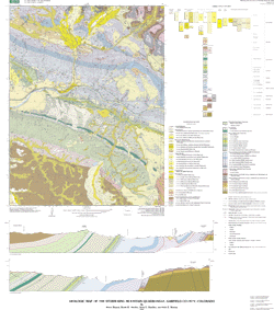
Bedrock geology mapped by Bruce Bryant, 1995-1997. Surficial geology mapped by Ralph R. Shroba, 1992-1993. Digitized by Anne E. Harding, 1997-1998. Conversion to ARC/INFO format and preparation of metadata by Kyle E. Murray, 2000-2002
Update and reinterpret earlier geologic mapping, and provide sufficient geologic information for land-use decisions.
Are there legal restrictions on access or use of the data?Access_Constraints: none
Use_Constraints:These data are intended for use at 1:24,000 scale. Acknowledgment of the USGS would be appropriate in products derived from these data. Any hardcopies utilizing these data sets shall clearly indicate their source. If the user has modified the data in any way they are obligated to describe the types of modifications they have performed on the hardcopy map. User specifically agrees not to misrepresent these data sets, nor to imply that changes were approved by the USGS or the authors of this geologic map database.
Although these data have been used by the U.S. Geological Survey, U.S. Department of the Interior, no warranty expressed or implied is made by the U.S. Geological Survey as to the accuracy of the data.
The act of distribution shall not constitute any such warranty, and no responsibility is assumed by the U.S. Geological Survey in the use of this data, software, or related materials.
| Data format: | Geologic units and structural features in format ARCE (version 8.1) Size: 1.1 |
|---|---|
| Network links: |
http://pubs.usgs.gov/mf/2002/mf-2389/mf-2389.tar.gz http://pubs.usgs.gov/mf/2002/mf-2389/mf-2389.zip |
| Data format: | Geologic units and structural features in format Shapefile (version 1.0) Size: 1.1 |
|---|---|
| Network links: |
http://pubs.usgs.gov/mf/2002/mf-2389/mf-2389.tar.gz http://pubs.usgs.gov/mf/2002/mf-2389/mf-2389.zip |