Generalized Geologic Map of the Upper Animas River Watershed and Vicinity, Silverton, Colorado

Metadata also available as - [Questions & Answers] - [Parseable text] - [XML]

Metadata:

Identification_Information:
Citation:
Citation_Information:
Originator: Douglas B. Yager
Originator: Dana J. Bove
Publication_Date: 2002
Title:
Generalized Geologic Map of the Upper Animas River Watershed and Vicinity, Silverton, Colorado
Edition: 1.0
Geospatial_Data_Presentation_Form: map
Series_Information:
Series_Name: U.S. Geological Survey Miscellaneous Field Studies Map
Issue_Identification: MF-2377
Publication_Information:
Publication_Place: Denver, Colorado
Publisher: U.S. Geological Survey
Online_Linkage: http://pubs.usgs.gov/mf/2002/mf-2377/
Description:
Abstract:
This dataset represents geology compiled for the upper Animas River Watershed near Silverton, Colorado. The source data used are derived from 1:24,000, 1:20,000, 1:48,000 and 1:250,000-scale geologic maps by geologists who have worked in this area since the early 1960's.
Purpose:
This map data was compiled for the purpose of comparing multiple Animas River Watershed Abandoned Mine Lands Project datasets such as geophysical, biologic, remote sensing, and geochemical datasets in a geologic context.
Supplemental_Information:
This product consists of seven vector coverages. These separate coverages include the geology, faults, veins, andesite dikes, dacite dikes, rhyolite dikes, and San Juan Caldera topographic margin.
Time_Period_of_Content:
Time_Period_Information:
Single_Date/Time:
Calendar_Date: 2002
Currentness_Reference: Publication date
Status:
Progress: Complete
Maintenance_and_Update_Frequency: None planned
Spatial_Domain:
Bounding_Coordinates:
West_Bounding_Coordinate: -107.87511
East_Bounding_Coordinate: -107.50006
North_Bounding_Coordinate: 38.00012
South_Bounding_Coordinate: 37.749787
Keywords:
Theme:
Theme_Keyword_Thesaurus: USGS Thesaurus
Theme_Keyword: abandoned mines and quarries
Theme_Keyword: geologic maps
Theme_Keyword: geology
Theme_Keyword: volcanology
Theme_Keyword: volcanic rocks
Theme_Keyword: bedrock geologic units
Theme_Keyword: geospatial datasets
Theme:
Theme_Keyword_Thesaurus: American Geological Institute (AGI) Glossary of Geology
Theme_Keyword: Animas River Watershed Abandoned Mine Lands Project
Theme_Keyword: U.S. Geological Survey Minerals Team
Theme_Keyword: geology
Theme_Keyword: volcanology
Theme_Keyword: caldera
Theme_Keyword: Silverton caldera
Theme_Keyword: San Juan caldera
Theme_Keyword: Oligocene calderas
Theme_Keyword: Paleozoic stratigraphy
Theme_Keyword: Mesozoic stratigraphy
Theme_Keyword: Tertiary stratigraphy
Theme_Keyword: Tertiary volcanics
Theme:
Theme_Keyword_Thesaurus: ISO 19115 Topic Categories
Theme_Keyword: geoscientificInformation
Place:
Place_Keyword_Thesaurus:
U.S. Board on Geographic Names (BGN) Geographic Names Information System (GNIS)
Place_Keyword: Animas River Watershed
Place_Keyword: southwestern Colorado
Place_Keyword: Silverton
Place_Keyword: San Juan County
Place_Keyword: Ouray County
Place_Keyword: San Miguel County
Place_Keyword: Hinsdale County
Place_Keyword: San Juan volcanic field
Place_Keyword: San Juan Mountains
Place_Keyword: San Juan National Forest
Place_Keyword: Uncompahgre National Forest
Place:
Place_Keyword_Thesaurus: Augmented FIPS 10-4 and FIPS 6-4
Place_Keyword: f08111 = San Juan
Place_Keyword: f08091 = Ouray
Place_Keyword: f08113 = San Miguel
Place_Keyword: f08053 = Hinsdale
Access_Constraints: None
Use_Constraints:
The intended scale of use for this data is 1:48,000. Over 90 percent of the data were compiled at 1:24,000 scale. Data for granitic intrusions in the southwest part of the project area were compiled from 1:250,000-scale data sources. Acknowledgment of the U.S. Geological Survey would be appreciated in products derived from these data.
Point_of_Contact:
Contact_Information:
Contact_Person_Primary:
Contact_Person: Douglas B. Yager
Contact_Organization: U.S. Geological Survey
Contact_Address:
Address_Type: mailing address
Address:
Denver Federal Center, MS-973
Box 25046
City: Denver
State_or_Province: Colorado
Postal_Code: 80225
Country: USA
Contact_Voice_Telephone: 303-236-2487
Contact_Electronic_Mail_Address: dyager@usgs.gov
Browse_Graphic:
Browse_Graphic_File_Name: http://pubs.usgs.gov/mf/2002/mf-2377/mf-2377.gif
Browse_Graphic_File_Description:
Reduced-size image of the map sheet, 250x152 pixels, 32-bit RGB true color, 25k bytes.
Browse_Graphic_File_Type: GIF
Browse_Graphic:
Browse_Graphic_File_Name: http://pubs.usgs.gov/mf/2002/mf-2377/mf-2377.pdf
Browse_Graphic_File_Description: printable graphic representation of map sheet
Browse_Graphic_File_Type: PDF
Data_Set_Credit:
D.B. Yager compiled and digitized geology for the Ironton, Ophir, Howardsville, and Silverton quadrangles with contribution of a digital coverage provided by R.G. Luedke for the Silverton quadrangle. D.J. Bove compiled geology for the Handies Peak quadrangle.
Native_Data_Set_Environment: ArcInfo 7.2.1, Sun Unix platform
Data_Quality_Information:
Attribute_Accuracy:
Attribute_Accuracy_Report:
100 percent of formation attributes were compared to paper maps for accuracy when compiled and digitized. The authors included a revised interpretation of the geology of some of the volcanic units located in the western part of the map area, based on newly acquired isotopic dates (Bove and others, 1999). Thus, the percentage of San Juan Formation on our map is greater and differs from the percentage of this unit from other sources used for the compilation such as (Luedke, 1996). Field checks of every unit, fault, vein, or dike were not attempted due to the time constraints and focus and scope of the project. The user should note that the authors compiled data for the Howardsville quadrangle from one preliminary data source (Luedke, 1975b), thus the lack of detail in the western part of this quadrangle. A quantitative assessment of attribute accuracy was not attempted. Frequency tests were run on the arc and polygon labels to ensure that no features are unlabeled. The attributes have been checked by both the authors and the reviewers for agreement with published maps, unpublished field mapping, and preliminary drafted versions of the map.
Logical_Consistency_Report:
Polygon and chain-node topology present. Each polygon is closed and has one label point. Polygon and chain-node topology present. Each polygon is closed and has one label point.
Completeness_Report:
Completeness of the data is a function of source maps used, generalization of units, faults, and veins strategy developed by the authors during compilation, and field checking accomplished in the course of mapping altered bedrock regions. Some source data was not complete and "preliminary" such as in the western part of the Howardsville quadrangle.
Positional_Accuracy:
Horizontal_Positional_Accuracy:
Horizontal_Positional_Accuracy_Report:
The estimated horizontal positional accuracy of the data is 10 meters. All data used from published and unpublished digital sources are limited by the accuracy of that data. Attempts were made to verify the accuracy of these data by comparison to published topographic data and overlap with other digital data.
Lineage:
Source_Information:
Source_Citation:
Citation_Information:
Originator: Burbank, W.S.
Originator: Luedke, R.G.
Publication_Date: 1964
Title: Geology of the Ironton quadrangle, Colorado: scale 1:24,000
Series_Information:
Series_Name: U.S. Geological Survey Geologic Quadrangle Map
Issue_Identification: GQ-291
Publication_Information:
Publication_Place: Denver, Colorado
Publisher: U.S. Geologial Survey
Type_of_Source_Media: paper
Source_Time_Period_of_Content:
Time_Period_Information:
Single_Date/Time:
Calendar_Date: 1964
Source_Currentness_Reference: publication date
Source_Citation_Abbreviation: Burbank and Luedke, 1964
Source_Contribution: Geology compiled for the Ironton quadrangle
Source_Information:
Source_Citation:
Citation_Information:
Originator: Steven, T.A.
Originator: Lipman, P.W.
Originator: Hail, W.J., Jr.
Originator: Barker, Fred
Originator: Luedke, R.G.
Publication_Date: 1974
Title:
Geologic map of the Durango quadrangle, southwestern Colorado: scale 1:250,000
Series_Information:
Series_Name: U.S. Geological Survey Miscellaneous Investigations Series Map
Issue_Identification: I-764
Publication_Information:
Publication_Place: Denver, Colorado
Publisher: U.S. Geological Survey
Type_of_Source_Media: map
Source_Time_Period_of_Content:
Time_Period_Information:
Single_Date/Time:
Calendar_Date: 1974
Source_Currentness_Reference: publication date
Source_Citation_Abbreviation: Steven and others, 1974
Source_Contribution:
granitic intrusion compiled from near the mouth of Cunningham Creek
Source_Information:
Source_Citation:
Citation_Information:
Originator: Luedke, R.G.
Originator: Burbank, W.S.
Publication_Date: 1975
Title:
Preliminary geologic map of the Silverton quadrangle, Colorado: scale 1:20,000
Series_Information:
Series_Name: U.S. Geological Survey Open-File Report
Issue_Identification: Open-File Report 75-0433
Publication_Information:
Publication_Place: Denver, Colorado
Publisher: U.S. Geological Survey
Type_of_Source_Media: paper
Source_Time_Period_of_Content:
Time_Period_Information:
Single_Date/Time:
Calendar_Date: 1975
Source_Currentness_Reference: publication date
Source_Citation_Abbreviation: Luedke and Burbank, 1975a
Source_Contribution: Geology compiled for the Silverton quadrangle
Source_Information:
Source_Citation:
Citation_Information:
Originator: Luedke, R.G.
Originator: Burbank, W.S.
Publication_Date: 1975
Title:
Preliminary geologic map of the Howardsville quadrangle, Colorado: scale 1:20,000
Series_Information:
Series_Name: U.S. Geological Survey Open-File Report
Issue_Identification: Open-File Report 75-0432
Publication_Information:
Publication_Place: Denver, Colorado
Publisher: U.S. Geological Survey
Type_of_Source_Media: paper
Source_Time_Period_of_Content:
Time_Period_Information:
Single_Date/Time:
Calendar_Date: 1975
Source_Currentness_Reference: publication date
Source_Citation_Abbreviation: Luedke and Burbank, 1975b
Source_Contribution: Geology compiled for the Howardsville quadrangle
Source_Information:
Source_Citation:
Citation_Information:
Originator: Lipman, P.W.
Publication_Date: 1976
Title:
Geologic map of the Lake City caldera area, western San Juan Mountains, southwestern Colorado: scale 1:48,000
Series_Information:
Series_Name: U.S. Geological Survey Miscellaneous Investigations Series Map
Issue_Identification: I-0962
Publication_Information:
Publication_Place: Denver, Colorado
Publisher: U.S. Geological Survey
Type_of_Source_Media: paper
Source_Time_Period_of_Content:
Time_Period_Information:
Single_Date/Time:
Calendar_Date: 1976
Source_Currentness_Reference: publication date
Source_Citation_Abbreviation: Lipman, 1976
Source_Contribution:
Geology compiled for part of the Howardsville and Handies Peak quadrangle
Source_Information:
Source_Citation:
Citation_Information:
Originator: Luedke, R.G
Originator: Burbank, W.S.
Publication_Date: 1987
Title:
Geologic map of the Handies Peak quadrangle, San Juan, Hinsdale, and Ouray Counties, Colorado: scale 1:24,000
Series_Information:
Series_Name: U.S. Geological Survey Geologic Quadrangle Map
Issue_Identification: GQ-1595
Publication_Information:
Publication_Place: Denver, Colorado
Publisher: U.S. Geological Survey
Type_of_Source_Media: map
Source_Time_Period_of_Content:
Time_Period_Information:
Single_Date/Time:
Calendar_Date: 1987
Source_Currentness_Reference: publication date
Source_Citation_Abbreviation: Luedke and Burbank, 1987
Source_Contribution: Geology compiled for part of the Handies Peak quadrangle
Process_Step:
Process_Description:
Data from source maps were compiled onto stable mylar base material with use of stable, U.S. Geological Survey green line topographic base materials as a guide for transfer of geologic contacts. Drafted line work was scanned with a scan resolution of 400 dpi. ARC INFO commands, IMAGEGRID and GRIDLINE,were used for raster to vector conversion. The vector cover produced was projected first with use of the ARC INFO TRANSFORM command. The vector coverage was TRANSFORMED into an empty TICCOV derived from the vector coverage with defined corner coordinate tics with geographic data. Once transformed, the coverage was projected using ARC INFO's project command. ARCEDIT's EDGEMATCH command was utilized to join adjacent quadrangle map data. Label errors were determined and corrected and the coverage topology was established with the CLEAN command.
Process_Date: 1996 to 2000
Process_Step:
Process_Description: Creation of original metadata record
Process_Date: 20090518
Process_Contact:
Contact_Information:
Contact_Person_Primary:
Contact_Person: Douglas B. Yager
Contact_Organization: U.S. Geological Survey
Contact_Address:
Address_Type: mailing address
Address:
Box 25046
Denver Federal Center, MS-973
City: Denver
State_or_Province: Colorado
Postal_Code: 80225
Country: USA
Contact_Voice_Telephone: (303) 236-2487
Contact_Electronic_Mail_Address: dyager@usgs.gov
Spatial_Data_Organization_Information:
Direct_Spatial_Reference_Method: Vector
Spatial_Reference_Information:
Horizontal_Coordinate_System_Definition:
Planar:
Grid_Coordinate_System:
Grid_Coordinate_System_Name: Universal Transverse Mercator
Universal_Transverse_Mercator:
UTM_Zone_Number: 13
Transverse_Mercator:
Scale_Factor_at_Central_Meridian: .9996
Longitude_of_Central_Meridian: -105.0
Latitude_of_Projection_Origin: 0.0
False_Easting: 500000.0
False_Northing: 0.0
Planar_Coordinate_Information:
Planar_Coordinate_Encoding_Method: coordinate pair
Coordinate_Representation:
Abscissa_Resolution: 65
Ordinate_Resolution: 65
Planar_Distance_Units: meters
Geodetic_Model:
Horizontal_Datum_Name: North American Datum of 1927
Ellipsoid_Name: Clarke 1866
Semi-major_Axis: 6378206.4
Denominator_of_Flattening_Ratio: 294.98
Entity_and_Attribute_Information:
Overview_Description:
Entity_and_Attribute_Overview:
The data are supplied in ARC/INFO export format and in ArcView shapefile format. 
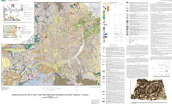
DATABASE STRUCTURE--The database structure of the map consists of seven coverages.
GEO coverage--Contains all contact lines and label points for each polygon. The GEO.PAT INFO file has attribute fields for INFO ITEMS POLY-ID, NAME, COLOR, LITH, and AGE. POLY-ID corresponds to a unique numeric polygon identifier that relates to each formation type; NAME corresponds to the formation name; COLOR corresponds to the ARC INFO colornames.shd symbolset number used for color shading; LITH corresponds to the unit litology, or rock type; AGE corresponds to the geologic age.
The GEO.AAT attributes are described below.
FAULTS coverage--Contains all lines, which represent faults and or combined fault and vein structures. Some faults correspond with geologic contacts in the GEO coverage. The FAULTS coverage has the attribute items LINE_ID and TYPE. The attribute item in the ARC INFO file FAULTS.AAT contains the LINE_ID attribute, which has a number that corresponds with fault type, that is, concealed, inferred, and so forth; the TYPE field contains the fault type description.
VEINS coverage--Contains arcs for mineralized, altered veins and fissures. The attribute item in the INFO file VEINS.AAT contains an ARC INFO ITEM fields LINE_ID and TYPE. The LINE_ID contains a number that corresponds with vein type, that is, concealed vein, mineral fissure, and so forth; the TYPE field contains a description of the vein type.
A_DIKE coverage--Contains lines for dikes of andesitic(?) (52-68 percent SiO2) composition.
D_DIKE coverage--Contains lines for dikes of dacitic (63-68 percent SiO2) composition.
R_DIKE coverage--Contains lines for dikes of rhyolitic (>68 percent SiO2) composition.
SJCALD coverage--Contains lines that define the topographic margin of the San Juan caldera; the SJCALD.AAT attributes are described below.
The following detailed overview discusses all of the non common attributes included in each of the seven coverages that constitute the geologic map.
The GEO coverage includes the INFO files GEO.PAT and GEO.AAT.
The INFO file GEO.PAT has populated attribute fields for items POLY-ID, NAME, COLOR, LITH, and AGE. POLY-ID is the unique numeric polygon code that corresponds to each formation type. NAME is the formation name. COLOR is the ARC INFO colornames.shd symbolset number used for color shading. LITH is the unit lithology. (Note--abbreviations are used for some unit LITH descriptions and they are as follows-siltst = siltstone, dol. = dolomite, sandst. = sandstone, calc. = calcareous, limest. = limestone, congl. = conglomerate, and mudst. = mudstone.) AGE is the geologic age.
Attribute codes for all geologic units are defined in order of (POLY-ID,NAME,COLOR,LITH,AGE) as follows-
(1,Tsp,60,rhyolite ash flow tuff,Miocene)
(3,Qb,1,N.A.,Quaternary)
(4,lake,21,N.A.,Quaternary)
(7,Tcl,74,rhyolite ash flow tuff,Oligocene)
(8,Ti,96,intrusions of unknown composition,Tertiary),
(9,Qu,16,undifferentiated surficial deposits,Quaternary)
(10,Qtg,17,talus,glacial till and rock glacier deposits,Quaternary)
(11,Qal,6,unconsolidated fluvial deposits including alluvial fans, Quaternary)
(12,Qcl,95,landslide and colluvium deposits,Quaternary)
(19,Tir,118,rhyolite dikes and plugs,Miocene)
(20,Tid,109,dacite intrusions,Oligocene to Miocene)
(22,Tse,71,rhyolitic to dacitic ash flow tuff,Oligocene)
(24,Ts,71,rhyolitic ash flow tuff,Oligocene)
(25,Td,69,rhyolitic ash flow tuff,Oligocene)
(27,Tb,68,rhyolitic ash flow tuff,Oligocene)
(28,Tur,70,dacitic ash flow tuff,Oligocene)
(29,Tig,25,monzonite to granodiorite stock,Oligocene)
(30,Tsv,12,mostly intermediate comp. lava flows,volcaniclastics, Oligocene)
(32,Tip,84,andesite to dacite ash flow tuff and breccia,Oligocene)
(34,Tsj,24,mostly intermediate comp. volcaniclastics,lavas,Oligocene)
(35,Tt,127,conglomerate and sandstone,Eocene)
(36,Kg,113,granodiorite,Cretaceous)
(37,Jm,65,sandstone and calcareous mudstone,Jurassic)
(38,Je,58,sandstone,Jurassic)
(39,Trd,49,siltst.,sandst., with limest.&congl. interbeds,Triassic)
(40,Pc,36,shale,sandst.,&congl., locally calcareous,Permian)
(41,Ph,23,sandst., with shale,sandst.,&congl.interbeds,Pennsylvanian)
(42,Phm,30,shale, sandstone, and conglomerate,Pennsylvanian)
(43,Pm,48,calcareous shale, sandstone, and conglomerate,Pennsylvanian)
(44,Ml,36,limestone w. chert/shale interbeds (top),Mississippian)
(45,Mdu,128,altered limestone,Mississippian)
(45,Mdu?,128,altered limestone,Mississippian)
(46,De,129,dol. limest., w. calc. shale & sandst. interbeds,Devonian)
(48,Ci,52,quartzite,Cambrian)
(49,pCu,121,schist,quartzite,and gneiss,Precambrian)
(50,Do,93,dolomite and limestone,Devonian)
(51,Jw,63,calc. mudst.&siltst., w. limest. sandst. interbeds,Jurassic)
(52,Km,19,shale,Cretaceous)
(53,Kd,20,sandst. w. siltst. & calc. shale interbeds,Cretaceous)
(59,Tf,59,dacite ash flow tuff,Oligocene)
(60,UM,2,Not mapped)
The INFO file GEO.AAT contains the attribute field LINE_ID, which in all cases is equal to "1" and which represents a solid contact.
The FAULTS coverage is comprised of the INFO file FAULTS.AAT. FAULTS.AAT contains the attribute items LINE_ID and TYPE. LINE_ID contains a number, which corresponds to a fault type; TYPE contains the description of the fault type. The LINE_ID = TYPE are described as follows--LINE_ID = 2, TYPE "Fault", LINE_ID = 8, TYPE "concealed or inferred fault".
The VEINS coverage is comprised of the INFO file VEINS.AAT. VEINS.AAT contains the attribute items LINE_ID and TYPE. LINE_ID contains a number,which corresponds to the vein type; TYPE contains the description of the vein type. The LINE_ID = TYPE are described as follows--LINE_ID = 22, TYPE "Vein", LINE_ID = 23, TYPE "Mineral fissure", LINE_ID = 24, TYPE = "Concealed vein or fault".
The coverage A_DIKE (andesite dikes) includes the INFO FILE A_DIKE.AAT that has an attribute field LINE_ID; the LINE_ID = 5 in all instances.
The coverage D_DIKE (dacite dike) includes the INFO FILE D_DIKE.AAT that has an attribute field LINE_ID; the LINE_ID = 6 in all instances.
The coverage R_DIKE (rhyolite dike) includes the INFO FILE R_DIKE.AAT that has an attribute field LINE_ID; the LINE_ID = 4 in all instances.
The coverage SJCALD (San Juan caldera topographic margin) includes the INFO FILE SJCALD.AAT that has attribute fields LINE_ID and Type. LINE_ID contains a number that corresponds to the topographic margin type. The LINE_ID = TYPE are described as follows--LINE_ID = 14 indicates the topographic margin and LINE_ID = 15 is the concealed or approximately located topographic margin.
Entity_and_Attribute_Detail_Citation: http://pubs.usgs.gov/mf/2002/mf-2377/mf-2377_508.pdf
Distribution_Information:
Distributor:
Contact_Information:
Contact_Organization_Primary:
Contact_Organization: U.S. Geological Survey
Contact_Address:
Address_Type: mailing address
Address: Central Publications Group
Address: MS 902, Box 25046
Address: Denver Federal Center
City: Denver
State_or_Province: Colorado
Postal_Code: 80225
Country: USA
Contact_Voice_Telephone: (303)236-5486
Contact_Electronic_Mail_Address: webmaster@geology.cr.usgs.gov
Distribution_Liability:
The U.S. Geological Survey (USGS) provides these geographic data " as is". The USGS makes no guarantee or warranty concerning the accuracy of information contained in the geographic data. The USGS further makes no warranties, either expressed or implied as to any other matter whatsoever, including, without limitation, the condition of the product, or its fitness for any particular purpose. The burden for determining fitness for use lies entirely with the user. Although these data have been processed successfully on computers at the USGS, no warranty, expressed or implied, is made by the USGS regarding the use of these data on any other system, nor does the fact of distribution constitute or imply any such warranty.
Standard_Order_Process:
Digital_Form:
Digital_Transfer_Information:
Format_Name: ARCE
Format_Version_Number: 7.2.1
Format_Information_Content: Geologic units and structural features
File_Decompression_Technique:
.tar.gz - UNIX gzip-compressed TAR file - use GNU zip and TAR to extract .ZIP - Windows ZIP archive - use Winzip, PKZip, or similar to extract
Digital_Transfer_Option:
Online_Option:
Computer_Contact_Information:
Network_Address:
Digital_Form:
Digital_Transfer_Information:
Format_Name: Shapefile
Format_Version_Number: 1.0
Format_Information_Content: Geologic units and structural features
File_Decompression_Technique:
.tar.gz - UNIX gzip-compressed TAR file - use GNU zip and TAR to extract .ZIP - Windows ZIP archive - use Winzip, PKZip, or similar to extract
Digital_Transfer_Option:
Online_Option:
Computer_Contact_Information:
Network_Address:
Fees: none
Metadata_Reference_Information:
Metadata_Date: 20160613
Metadata_Contact:
Contact_Information:
Contact_Person_Primary:
Contact_Person: Peter N Schweitzer
Contact_Organization: USGS Midwest Area
Contact_Position:
Collection manager, USGS Geoscience Data Clearinghouse, http://geo-nsdi.er.usgs.gov/
Contact_Address:
Address_Type: mailing address
Address:
Mail Stop 954
12201 Sunrise Valley Dr
City: Reston
State_or_Province: VA
Postal_Code: 20192-0002
Country: USA
Contact_Voice_Telephone: 703-648-6533
Contact_Facsimile_Telephone: 703-648-6252
Contact_Electronic_Mail_Address: pschweitzer@usgs.gov
Metadata_Standard_Name: Content Standard for Digital Geospatial Metadata
Metadata_Standard_Version: FGDC-STD-001-1998
Metadata_Access_Constraints: None
Metadata_Use_Constraints: None


This page is <https://geo-nsdi.er.usgs.gov/metadata/map-mf/2377/metadata.html>
Generated by mp version 2.9.48 on Tue Jul 03 20:05:11 2018