Citation:
Citation_Information:
Originator: McLaughlin, R.J.
Originator: Clark, J.C.
Originator: Brabb, E.E.
Originator: Helley, E.J.
Originator: Colón, C.J.
Originator: Valin, Z.C.
Originator: Wentworth, C.M.
Originator: Minnick, J.L.
Originator: May, T.E.
Originator: Randolph, C.R.
Originator: Gerhardt, Lisa
Originator: Nelson, C.E.
Originator: Showalter, Patrick
Originator: Lindquist, T.A.
Publication_Date: 2001
Title:
Geologic maps and structure sections of the southwestern Santa
Clara Valley and southern Santa Cruz Mountains, Santa Clara and
Santa Cruz Counties, California
Edition: 1.0
Geospatial_Data_Presentation_Form: map
Series_Information:
Series_Name: U.S. Geological Survey Miscellaneous Field Studies Report
Issue_Identification: MF-2373
Publication_Information:
Publication_Place: Menlo Park, CA
Publisher: U.S. Geological Survey
Online_Linkage: http://pubs.usgs.gov/mf/2002/2373/
Description:
Abstract:
This digital map database, compiled from previously published
and unpublished data, and new mapping by the authors,
represents the general distribution of bedrock and surficial
deposits in the mapped area. Together with the accompanying
text file (scvmf.ps, scvmf.pdf, scvmf.txt), it provides current
information on the geologic structure and stratigraphy of the
area covered. The database delineates map units that are
identified by general age and lithology following the
stratigraphic nomenclature of the U.S. Geological Survey. The
scale of the source maps limits the spatial resolution (scale)
of the database to 1:24,000 or smaller.
Purpose:
This database and accompanying plot files depict the
distribution of geologic materials and structures at a
regional (1:24,000) scale. The report is intended to provide
geologic information for the regional study of materials
properties, earthquake shaking, landslide potential, mineral
hazards, seismic velocity, and earthquake faults. In addition,
the report contains new information and interpretations about
the regional geologic history and framework. However, the
regional scale of this report does not provide sufficient
detail for site development purposes. In addition, this map
does not take the place of fault-rupture hazard zones
designated by the California State Geologist (Hart and Bryant,
1997). Similarly, the database cannot be substituted for
comprehensive maps that systematically identify and classify
landslide hazards.
Time_Period_of_Content:
Time_Period_Information:
Range_of_Dates/Times:
Beginning_Date: 1988
Ending_Date: 1997
Currentness_Reference: mapping carried out during this period
Status:
Progress: Complete
Maintenance_and_Update_Frequency: As needed
Spatial_Domain:
Bounding_Coordinates:
West_Bounding_Coordinate: -121.99997057
East_Bounding_Coordinate: -121.54756309
North_Bounding_Coordinate: 37.25153532
South_Bounding_Coordinate: 36.99845865
Keywords:
Theme:
Theme_Keyword_Thesaurus: USGS Thesaurus
Theme_Keyword: geology
Theme_Keyword: geologic maps
Theme_Keyword: bedrock geologic units
Theme_Keyword: surficial geologic units
Theme_Keyword: geologic history
Theme_Keyword: geologic structure
Theme_Keyword: faulting (geologic)
Theme_Keyword: geospatial datasets
Theme:
Theme_Keyword_Thesaurus: none
Theme_Keyword: geology
Theme_Keyword: bedrock geology
Theme_Keyword: surficial geology
Theme_Keyword: geologic history
Theme_Keyword: Franciscan complex
Theme_Keyword: Coast Range ophiolite
Theme_Keyword: Great Valley sequence
Theme_Keyword: stratigraphic assemblages
Theme_Keyword: geologic structures
Theme_Keyword: San Andreas fault
Theme_Keyword: Zayante fault
Theme_Keyword: Sargent fault
Theme_Keyword: Berrocal fault
Theme_Keyword: Sierra Azul fault
Theme_Keyword: Aldercroft fault
Theme_Keyword: Coast Range fault
Theme_Keyword: Monte Vista fault
Theme_Keyword: San Jose fault
Theme_Keyword: Hayward fault
Theme_Keyword: Shannon fault zone
Theme_Keyword: Lexington fault zone
Theme_Keyword: Piercy fault zone
Theme_Keyword: Hayward-Calaveras fault system
Theme_Keyword: Soda Springs fault
Theme_Keyword: Hooker Gulch fault
Theme_Keyword: San Gregorio fault
Theme_Keyword: Santa Cruz fault block
Theme_Keyword: Ben Lomond fault block
Theme_Keyword: La Honda fault block
Theme_Keyword: New Almaden fault block
Theme_Keyword: Sierra Azul fault block
Theme_Keyword: Santa Teresa Hills fault block
Theme_Keyword: Permanente terrane
Theme_Keyword: Loma Prieta earthquake
Theme_Keyword: San Francisco earthquake of 1906
Theme:
Theme_Keyword_Thesaurus: ISO 19115 Topic Categories
Theme_Keyword: geoscientificInformation
Place:
Place_Keyword_Thesaurus: none
Place_Keyword: United States of America
Place_Keyword: California
Place_Keyword: Santa Clara County
Place_Keyword: Santa Cruz County
Place:
Place_Keyword_Thesaurus: Augmented FIPS 10-4 and FIPS 6-4
Place_Keyword: f06085 = Santa Clara
Place_Keyword: f06087 = Santa Cruz
Stratum:
Stratum_Keyword_Thesaurus: None
Stratum_Keyword: Mine dump
Stratum_Keyword: Gravel pit
Stratum_Keyword: Percolation pond
Stratum_Keyword: Artificial fill
Stratum_Keyword: Stream channel deposits
Stratum_Keyword: Alluvial fan deposits (Holocene)
Stratum_Keyword: Basin deposits
Stratum_Keyword: Levee deposits
Stratum_Keyword: Floodplain deposits
Stratum_Keyword: Alluvium, undivided
Stratum_Keyword: Landslide deposits, undivided
Stratum_Keyword: Alluvial terrace deposits, undivided
Stratum_Keyword: Marine terrace deposits
Stratum_Keyword: Aromas Sand
Stratum_Keyword: Dune deposits
Stratum_Keyword: Fluvial deposits
Stratum_Keyword: Alluvial fan deposits (Pleistocene)
Stratum_Keyword: Older alluvium, undivided
Stratum_Keyword: Older floodplain deposits
Stratum_Keyword: Santa Clara Formation
Stratum_Keyword: Fluvial deposits, undivided
Stratum_Keyword: Silica-carbonate rock
Stratum_Keyword: Unnamed sandstone
Stratum_Keyword: Monterey Shale
Stratum_Keyword: Temblor Sandstone
Stratum_Keyword: Volcanic and intrusive rocks
Stratum_Keyword: Serpentinized ultramafic rocks
Stratum_Keyword: Franciscan Complex
Stratum_Keyword: Melange of the Central belt
Stratum_Keyword: Blueschist blocks
Stratum_Keyword: Amphibolite blocks
Stratum_Keyword: Chert blocks
Stratum_Keyword: Basaltic volcanic rock blocks
Stratum_Keyword: Conglomerate block
Stratum_Keyword: Metadiorite block
Stratum_Keyword: Permanente terrane
Stratum_Keyword: Foraminiferal limestone
Stratum_Keyword: Volcanic rocks
Stratum_Keyword: Siliceous radiolarian-bearing tuff
Stratum_Keyword: Marin Headlands terrane
Stratum_Keyword: Sandstone (Upper and (or) Lower Cretaceous)
Stratum_Keyword: Radiolarian chert
Stratum_Keyword: Basaltic volcanic rocks
Stratum_Keyword: Shale and sandstone of Highland Way
Stratum_Keyword: Sandstone and shale of Loma Chiquita Ridge
Stratum_Keyword: Siliceous mudstone
Stratum_Keyword: Sandstone and mudstone
Stratum_Keyword: Mottled mudstone and sandstone of Mount Chual
Stratum_Keyword: Sandstone lenses
Stratum_Keyword: Limestone
Stratum_Keyword: Great Valley Sequence
Stratum_Keyword: Sandstone and shale
Stratum_Keyword: Conglomerate (Upper Cretaceous)
Stratum_Keyword: Mudstone (Lower Cretaceous and Upper Jurassic)
Stratum_Keyword: Sedimentary serpentinite
Stratum_Keyword: Altered tuff of Mount Umunhum
Stratum_Keyword: Diabase breccia of Mount Umunhum
Stratum_Keyword: Coast Range Ophiolite
Stratum_Keyword: Quartz-keratophyre breccia and siliceous tuff
Stratum_Keyword: Basalt, andesite and dacite
Stratum_Keyword: Intrusive complex
Stratum_Keyword: Gabbro cumulates
Stratum_Keyword: Ultramafic cumulates
Stratum_Keyword: Serpentinized ultramafic rocks
Stratum_Keyword: Slate of Loma Prieta Peak
Stratum_Keyword: Diabase of Corralitos Creek
Stratum_Keyword: Purisima Formation
Stratum_Keyword: Santa Cruz Mudstone
Stratum_Keyword: Santa Margarita Sandstone
Stratum_Keyword: Monterey Formation
Stratum_Keyword: Lompico Sandstone
Stratum_Keyword: Lambert Shale
Stratum_Keyword: Vaqueros Formation
Stratum_Keyword: Basalt flows
Stratum_Keyword: Zayante Sandstone
Stratum_Keyword: San Lorenzo Formation
Stratum_Keyword: Rices Mudstone Member
Stratum_Keyword: Twobar Shale Member
Stratum_Keyword: Butano Sandstone
Stratum_Keyword: Undivided sandstone and shale
Stratum_Keyword: Mudstone (late Eocene)
Stratum_Keyword: Sandstone (middle Eocene or younger)
Stratum_Keyword: Conglomerate (middle Eocene or younger)
Stratum_Keyword: Granitic and metamorphic rocks
Stratum_Keyword: Mafic basement rocks
Stratum_Keyword: Diabase and gabbro of Morrell Cutoff Road and Laurel Creek
Temporal:
Temporal_Keyword_Thesaurus: None
Temporal_Keyword: Mesozoic
Temporal_Keyword: Jurassic
Temporal_Keyword: Cretaceous
Temporal_Keyword: Cenozoic
Temporal_Keyword: Tertiary
Temporal_Keyword: Paleogene
Temporal_Keyword: Neogene
Temporal_Keyword: Paleocene
Temporal_Keyword: Eocene
Temporal_Keyword: Oligocene
Temporal_Keyword: Miocene
Temporal_Keyword: Pliocene
Temporal_Keyword: Quaternary
Temporal_Keyword: Pleistocene
Temporal_Keyword: Holocene
Access_Constraints: None
Use_Constraints:
Uses of this digital geologic map should not violate the spatial
resolution of the data. Although the digital form of the data
removes the constraint imposed by the scale of a paper map, the
detail and accuracy inherent in map scale are also present in the
digital data. The fact that this database was edited for a scale
of 1:24,000 means that higher resolution information is not
present in the dataset. Plotting at scales larger than 1:24,000
will not yield greater real detail, although it may reveal fine-
scale irregularities below the intended resolution of the
database. Similarly, where this database is used in combination
with other data of higher resolution, the resolution of the
combined output will be limited by the lower resolution of these
data.
Point_of_Contact:
Contact_Information:
Contact_Organization_Primary:
Contact_Organization: USGS Western Earth Surface Processes Team
Contact_Person: Database coordinator
Contact_Address:
Address_Type: mailing address
Address: 345 Middlefield Road, MS 975
City: Menlo Park
State_or_Province: CA
Postal_Code: 94025
Country: USA
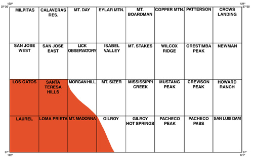
Browse_Graphic:
Browse_Graphic_File_Name: http://pubs.usgs.gov/mf/2002/2373/images/index.jpg
Browse_Graphic_File_Description:
Index map of 7.5' quadrangles in the 1:100,000 San Jose quadrangle.
Area of report shown in red. 500x311 pixels, 32-bit RGB true color,
35 kbytes.
Browse_Graphic_File_Type: JPEG
Browse_Graphic:
Browse_Graphic_File_Name: http://pubs.usgs.gov/mf/2002/2373/lgmap.pdf
Browse_Graphic_File_Description:
PDF file containing an image of the entire geologic map and base
maps of the Los Gatos quadrangle at a scale of 1:24,000 intended for
viewing. 4 megabytes.
Browse_Graphic_File_Type: PDF
Browse_Graphic:
Browse_Graphic_File_Name: http://pubs.usgs.gov/mf/2002/2373/lpmap.pdf
Browse_Graphic_File_Description:
PDF file containing an image of the geologic map and base maps of
the Loma Prieta quadrangle at a scale of 1:24,000 intended for
viewing. 2.7 megabytes.
Browse_Graphic_File_Type: PDF
Browse_Graphic:
Browse_Graphic_File_Name: http://pubs.usgs.gov/mf/2002/2373/lrmap.pdf
Browse_Graphic_File_Description:
PDF file containing an image of the geologic map and base maps of
the Laurel quadrangle at a scale of 1:24,000 intended for
viewing. 3.9 megabytes.
Browse_Graphic_File_Type: PDF
Browse_Graphic:
Browse_Graphic_File_Name: http://pubs.usgs.gov/mf/2002/2373/sth-mhmap.pdf
Browse_Graphic_File_Description:
PDF file containing an image of the geologic map and base maps of
the Santa Teresa Hills and southwestern part of the Morgan Hill
quadrangle at a scale of 1:24,000 intended for viewing. 3.9 megabytes.
Browse_Graphic_File_Type: PDF
Browse_Graphic:
Browse_Graphic_File_Name: http://pubs.usgs.gov/mf/2002/2373/mm-glmap.pdf
Browse_Graphic_File_Description:
PDF file containing an image of the geologic map and base maps of
the Mount Madonna and southwestern part of the Gilroy quadrangle
at a scale of 1:24,000 intended for viewing. 3.2 megabytes.
Browse_Graphic_File_Type: PDF
Data_Set_Credit:
The geology of this area was mapped by R. J. McLaughlin, J. C.
Clark, E. E. Brabb, and E. J. Helley between 1988 and 1996; part
of the Mt. Madonna quadrangle was mapped by C. J. Colon from
1991-1992. The geology of the New Almaden area is partly
compiled from Bailey and Everhart, 1964. The geology along the
San Andreas fault is partly incorporated from Sarna-Wojcicki and
others, 1975 and from U. S. Geological Survey Staff, 1989.
Numerous scientists within the U.S. Geological Survey and from
academia, have contributed to this database:
Critical paleontologic support was provided by: K. McDougall-Reid
and Richard Pierce (deceased), Tertiary benthic foraminifers; D.
Bukry, Tertiary nannofossils; J. Barron, Tertiary diatoms; C.
Powell, W. Addicott, and J. Vedder, Tertiary macrofossils; W. V.
Sliter (deceased), Mesozoic foraminifers; B. Murchey, Y. Isozaki,
and I. Hattori, Mesozoic radiolaria; and W. Elder and D.L. Jones,
Mesozoic macrofossils.
Isotopic data for age and provenance determinations were provided
by R. Kistler and D. Champion, Rubidium and Strontium; J. Nakata,
D. Sorg and P. Russell, K-Ar and Ar-Ar radiometric ages; and J.
Wooden, U-Pb radiometric age.
A fission track age investigation, conducted in the map region in
1992-1994 by T. Dumitru, R. BŸrgmann, and Ramon Aerosmith, of
Stanford University, in cooperation with the senior author, has
contributed substantially to an understanding of the structural
history of this area.
The senior author (McLaughlin) also wishes to acknowledge the
following scientists for their collaborative and cooperative
work, that has strongly influenced interpretations of the geology
and crustal structure of the map region: R. Jachens, A. Griscom
and V. Langenheim (U.S.G.S.), modeling of gravity and
aeromagnetic data; R. BŸrgmann (Stanford, now at U.C. Berkeley),
geodetic data; C.M. Wentworth and R.G. Stanley (U.S.G.S.),
regional geology; R. Wells, D. Ponti, C. Prentice, D. Schwartz,
S. Ellen, and K. Schmidt, (all at the U.S.G.S.), and W. Cotton (
W. Cotton and Associates), detailed work on surface deformation
and active fault relationships following the 1989 Loma Prieta
earthquake.
The authors wish to acknowledge the many owners of large land
parcels and ranches in rural areas of Santa Clara and Santa Cruz
Counties, who have cooperated with these mapping investigations
by providing access to their properties and showing interest in
the work. We also thank the following private and public
agencies for their cooperation in allowing access and gate keys
to their properties, including the San Jose Water Company; Mid-
Peninsula Open-Space District; and the Santa Clara County Park
system.
We also wish to thank the California Division of Forestry,
particularly CDF Burrel Fire Station of Santa Cruz County, for
providing lodging to the senior author (McLaughlin) in the course
of mapping investigations.
This digital database was compiled in ARC/INFO, a commercial G.I.
S.(ESRI). The digital compilation was done using the 1996
version 3.0 of the menu interface ALACARTE (originally published
as version 1.0 by Fitzgibbon and Wentworth, 1991). The
digitization of geologic contacts, development and integration of
various data sets into the digital map database were largely
supervised by C. M. Wentworth (1988-1997). Numerous individuals
have compiled and edited parts of the digital files for this
publication at different times, including T. A. Lindquist (1988),
P. Showalter (1989-1990), C. E. Nelson (1994), L. Gerhardt (
1996), C. R. Randolph, T. E. May, and J. L. Minnick (1996-1998),
and Z. C. Valin (1996-2001). The digital geology was initially
compiled as a part of the geologic map database for the San Jose,
California 1:100,000-scale quadrangle (Wentworth and others,
unpublished, 1999) but the maps are herein released at 1:24,000.
Geologic mapping was at a scale of 1:24,000, which is therefore
the scale of maximum resolution. Enlargement of these maps to
scales substantially less than 1:24,000 is here considered
inappropriate.
Technical reviews of this report were provided by P. Stone (
Western Earth Surface Processes Team, U.S.G.S.) and by M. C.
Blake, Jr., (Emeritus). R. Graymer (Western Earth Surface
Processes Team, U.S.G.S.) reviewed the database. Technical
editing of this report for publication by the U.S. Geological
Survey was provided by J. Zigler, and preparation of the database
website was by R. Koch and C. Donlin (all at Western Publications
Unit, U.S.G.S.).
Note: Authorship of the geology of this publication resides in
the first five names in the author list in the order given. The
last nine names starting with Z.C. Valin, are the digital
database authors in the order given.
Native_Data_Set_Environment: SunOS, 5.5.1, sun4u UNIX, ARC/INFO version 7.2.1