 vwpoly: geologic polygons, contacts, faults, marker beds, and intra-unit scarps
 vwline: fold axes, concealed linear features, limits of abundant chert fragments in the Maroon Formation, and cross-section lines
 vwpoint: bedding and foliation attitudes, and miscellaneous point data
Online Links:
==========================================
COVERAGE: vwpoly
==========================================

------------------------------------------
USER DEFINED ITEMS IN VWPOLY.PAT:
------------------------------------------

ITEM NAME     WIDTH   TYPE   DESCRIPTION

DESCRIPTION   50      C      geologic unit name
SYMBOL        6       I      marker symbol number for plotting
LABEL         4       C      unit label for map plots (for example, "Qal")

ITEM VALUES AND RELATION OF ITEMS "DESCRIPTION", "LABEL", AND "SYMBOL"
 DESCRIPTION                                       LABEL    SYMBOL
 water                                                      56
 artificial fill                                    af       8
 modified land-surface deposit                      mls     76
 alluvium                                           Qal      2
 younger terrace alluvium                           Qty     23
 older terrace alluvium                             Qto    111
 younger fan alluvium and debris-flow deposits      Qfy     32
 older fan alluvium and debris-flow deposits        Qfo     51
 younger diamicton                                  Qdi     29
 older diamicton                                    QTdi    53
 colluvium, undivided                               Qc      12
 landslide deposits                                 Qls     16
 earth-flow deposit                                 Qef     28
 older colluvium                                    QTc    130
 Pinedale Till                                      Qtp     62
 Pinedale Till, uncertain                           Qtp?    62
 Bull Lake Till                                     Qtb     56
 Bull Lake Till, uncertain                          Qtb?    56
 till, undivided                                    Qti    101
 periglacial deposits                               Qpg    444
 outwash of periglacial deposits and Pinedale Till  Qo      49
 boulder-field deposits                             Qbf     79
 wetland deposits                                   Qw     429
 tufa deposits                                      Qtu     20
 tuffaceous sedimentary rocks                       Tst     50
 Dakota Sandstone                                   Kd     454
 Morrison Formation                                 Jm     427
 Entrada Sandstone                                  Je     365
 Chinle Formation                                   @c     510
 Maroon Fm., limestone bed                          ls      45
 Maroon Formation                                   P&m    320
 Eagle Valley Formation                             &ev    231
 Eagle Valley Evaporite                             &ee    241
 Minturn Fm., limestone bed                         ls      45
 Minturn Formation                                  &m     239
 Minturn Fm., Jacque Mountain Limestone Member      &mj    305
 Minturn Fm., White Quail Limestone Member          &mwq   379
 Minturn Fm., Robinson Limestone Member             &mr    349
 Minturn Fm., Robinson Limestone Member, uncertain  &mr?   349
 Minturn Fm., dolomite bed                          &md    333
 Minturn Fm., dolomite bed, uncertain               &md?   333
 Cross Creek Granite                                Xc     514
 migmatite                                          Xm     500

       In the "LABEL" item, the @ and & refer to the Triassic and
       Pennsylvanian symbols, respectively

------------------------------------------
USER DEFINED ITEMS IN VWPOLY.AAT:
------------------------------------------

ITEM NAME     WIDTH   TYPE   DESCRIPTION

DESCRIPTION   80      C      geologic or hydrologic feature (for
                                example, contact or shoreline)
ROCKUNIT      40      C      geologic unit name for thin beds
                                represented by lines (if applicable)
SYMBOL         3      I      marker symbol number for plotting

ITEM VALUES AND RELATION OF ITEMS "DESCRIPTION" AND "SYMBOL"
DESRIPTION                                                        SYMBOL
Map boundary                                                      50
contact, approximately located                                     2
contact, certain                                                   1
contact, landslide scarp, certain                                 15
contact, surficial unit deposited against fault scarp, inferred   57
high-angle reverse fault, inferred                                72
landslide scarp, certain                                          15
normal fault, approximately located                               51
normal fault, certain                                             50
normal fault, inferred                                           183
normal fault, inferred, queried                                  183
shoreline                                                          0
thin subunit, approximately located                               52
thin subunit, certain                                             50

ITEM VALUES FOR "ROCKUNIT"

Eagle Valley Evaporite, limestone bed
Jacque Mountain Limestone Member
Maroon Fm., dolomite bed
Maroon Fm., limestone bed
Minturn Fm., limestone bed
Robinson Limestone Member
Robinson Limestone Member, uncertain
White Quail Limestone Member


==========================================
COVERAGE:vwline
==========================================

------------------------------------------
USER DEFINED ITEMS IN VWLINE.AAT:
------------------------------------------

ITEM NAME      WIDTH   TYPE   DESCRIPTION

DESCRIPTION    30      C      geologic feature (for example, fold axis)
SYMBOL          3      I      marker symbol number for plotting

ITEM VALUES AND RELATION OF ITEMS "DESCRIPTION" AND "SYMBOL"

anticline, certain                        60
anticline, concealed                      63
anticline, inferred                       61
high-angle reverse fault, concealed       74
limit of abundant chert in Maroon Fm       4
line of cross-section                    210
normal fault, concealed                  184
syncline, certain                         92
syncline, concealed                       95
syncline, inferred                        93


==========================================
COVERAGE:vwpoint
==========================================

------------------------------------------
USER DEFINED ITEMS IN VWPOINT.PAT:
------------------------------------------

ITEM NAME      WIDTH   TYPE   DESCRIPTION

AZIMUTH         3      I      strike of planar feature or azimuth of linear feature
INCLINATION     3      I      dip of planar feature
DESCRIPTION    31      C      geologic or cultural feature (for example, foliation)
SYMBOLCODE      3      I      marker symbol number for plotting

ITEM VALUES FOR "AZIMUTH"
integer values from 0-359

ITEM VALUES FOR "INCLINATION"
integer values from 0-89

ITEM VALUES AND RELATION OF ITEMS "DESCRIPTION" AND "SYMBOLCODE"

adit                             103
outcrop, ash                     241
prospect pit                      53
strike and dip of foliation       81
strike and dip of inclined beds    2 (or 1 if inclination=0)
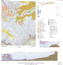
Dave Lidke and Bruce Bryant contributed to the geologic mapping of the Vail West quadrangle. Digital cartography by Daniel Grunwald.
This map was funded by and is a product of the National Cooperative Geologic Mapping Program. This corridor is experiencing rapid urban growth. Geologic mapping is needed to aid in land development planning in order to address, avoid, or mitigate known and potential geologic hazards.
Are there legal restrictions on access or use of the data?Access_Constraints: None
Use_Constraints:None. Acknowledgment of the U.S. Geological Survey would be appreciated in products derived from these data.
Although these digital spatial data have been subjected to rigorous review and are substantially complete, they are released on the condition that neither the USGS nor the United States Government may be held liable for any damages resulting from their authorized or unauthorized use.
| Data format: | Geologic units and structural features in format ARCE, Shapefile (version 8.0.2) Size: 1.5 |
|---|---|
| Network links: |
http://pubs.usgs.gov/mf/2002/mf-2369/mf-2369.tar.gz http://pubs.usgs.gov/mf/2002/mf-2369/mf-2369.zip |
| Data format: | Digital image of the topographic base map used in format TIFF (version 6.0) Size: 4.4 |
|---|---|
| Network links: |
http://pubs.usgs.gov/mf/2002/mf-2369/vwbase.tar.gz http://pubs.usgs.gov/mf/2002/mf-2369/vwbase.zip |