Geologic map of the Tetilla Peak quadrangle, Santa Fe and Sandoval Counties, New Mexico

Metadata also available as - [Questions & Answers] - [Parseable text] - [XML]

Metadata:

Identification_Information:
Citation:
Citation_Information:
Originator: David A. Sawyer
Originator: Ralph R. Shroba
Originator: Scott A. Minor
Originator: Ren A. Thompson
Originator: Jeffrey C. Blossom
Originator: Thomas R. Fisher
Originator: Ronald R. Wahl
Originator: D. Paco Van Sistine
Publication_Date: 2002
Title:
Geologic map of the Tetilla Peak quadrangle, Santa Fe and Sandoval Counties, New Mexico
Edition: Version 1.0
Geospatial_Data_Presentation_Form: Map
Series_Information:
Series_Name: U.S. Geological Survey Miscellaneous Field Studies Map
Issue_Identification: MF-2352
Publication_Information:
Publication_Place: Denver, Colorado
Publisher: U.S. Geological Survey
Online_Linkage: http://pubs.usgs.gov/mf/2002/mf-2352/
Description:
Abstract:
This digital geologic map summarizes all available geologic information for the Tetilla Peak quadrangle located immediately southwest of Santa Fe, New Mexico. The geologic map consists of new polygon (geologic map units) and line (contact, fault, fold axis, dike, flow contact, hachure) data, as well as point data (locations for structural measurements, geochemical and geochronologic data, geophysical soundings, and water wells). The map database has been generated at 1:24,000 scale, and provides significant new geologic information for an area of the southern Cerros del Rio volcanic field, which sits astride the boundary of the Espanola and Santo Domingo basins of the Rio Grande rift.
The quadrangle includes the west part of the village of La Cienega along its eastern border and includes the southeasternmost part of the Cochiti Pueblo reservation along its northwest side. The central part of the quadrangle consists of Santa Fe National Forest and Bureau of Land Management lands, and parts of several Spanish-era land grants.
Interstate 25 cuts through the southern half of the quadrangle between Santa Fe and Santo Domingo Pueblo. Canada de Santa Fe, a major river tributary to the Rio Grande, cuts through the quadrangle, but there is no dirt or paved road along the canyon bottom.
A small abandoned uranium mine (the La Bajada mine) is found in the bottom of the Canada de Santa Fe about 3 km east of the La Bajada fault zone; it has been partially reclaimed.
The surface geology of the Tetilla Peak quadrangle consists predominantly of a thin (1-2 m generally, locally as thick as 10? m) layer of windblown surficial deposits that has been reworked colluvially. Locally, landslide, fluvial, and pediment deposits are also important. These colluvial deposits mantle the principal bedrocks units, which are (from most to least common): (1) basalts, basanites, andesite, and trachyte of the Pliocene (2.7-2.2 Ma) Cerros del Rio volcanic field; (2) unconsolidated deposits of the Santa Fe Group, mainly along the western border, in the hanging wall of the La Bajada fault zone, but locally extending 2-3 km east under the Cerros del Rio volcanic field; (3) older Tertiary volcanic and sedimentary rocks (Abiquiu?, Espinaso, and Galisteo Formations); (4) intrusive rocks of the Cerrillos intrusive center that are roughly coeval with the Espinaso volcanic rocks; and (5) Mesozoic sedimentary rocks ranging in age from the Upper Triassic Chinle Formation to the Upper Cretaceous Mancos Shale.
Purpose:
The purpose of this mapping was to determine the bedrock geology that would control or impact ground-water flow from the Espanola basin into the Santo Domingo basin. As it is a multi-purpose geologic map, it is suitable as the geologic layer for any variety of interdisciplinary investigations incorporating geology as a theme.
Supplemental_Information:
GEOSPATIAL DATAFILES AND OTHER FILES INCLUDED IN THIS DATA SET: Map political location: Santa Fe and Sandoval Counties, New Mexico Compilation scale: 1:24,000 Geology mapped: 1996-1998
tepk_geol:           geologic units, faults, dikes, volcanic flow boundaries
tepk_struct:         bearing and attitude measurements of structural features
tepk_bed:            attitude measurements of geologic units
tepk_chem:           geochemical and geochronologic data by sample
tepk_amt:            audio-magneto-telluric (AMT) geophysical sample data
tepk_wells:          water well locations
tepk_marker:         cartographic decorations (bar and ball symbol, etc.)
color524.shd:        ArcInfo shadeset used to color geology polygons
geoscamp1.mrk:       ArcInfo markerset used to plot geologic symbols
geoscamp1.lin:       ArcInfo lineset used to plot geologic line symbols
tepk_base.tif,.tfw:  1:24,000-scale topographic base
Time_Period_of_Content:
Time_Period_Information:
Single_Date/Time:
Calendar_Date: 2000
Currentness_Reference: publication date
Status:
Progress: Complete
Maintenance_and_Update_Frequency:
None planned. Continuing investigations in the geology of the Cerros del Rio volcanic field may be summarized in a subsequent 1:50,000-scale synthesis map. Updates of the digital version of the geologic map will be released if needed, such as Version 2, 3, and so forth.
Spatial_Domain:
Bounding_Coordinates:
West_Bounding_Coordinate: -106.25
East_Bounding_Coordinate: -106.125
North_Bounding_Coordinate: 35.625
South_Bounding_Coordinate: 35.50
Keywords:
Theme:
Theme_Keyword_Thesaurus: USGS Thesaurus
Theme_Keyword: geology
Theme_Keyword: geologic maps
Theme_Keyword: bedrock geologic units
Theme_Keyword: geologic structure
Theme_Keyword: geospatial datasets
Theme_Keyword: geochemistry
Theme_Keyword: geochronology
Theme_Keyword: uranium
Theme_Keyword: abandoned mines and quarries
Theme_Keyword: electromagnetic surveying
Theme:
Theme_Keyword_Thesaurus: none
Theme_Keyword: Cerros del Rio volcanic field
Theme_Keyword: Hydrogeology
Theme_Keyword: Santa Fe Group
Theme_Keyword: Rio Grande rift
Theme_Keyword: Santo Domingo Basin
Theme:
Theme_Keyword_Thesaurus: ISO 19115 Topic Categories
Theme_Keyword: geoscientificInformation
Place:
Place_Keyword_Thesaurus: none
Place_Keyword: New Mexico
Place_Keyword: Santa Fe County
Place_Keyword: Sandoval County
Place_Keyword: Cochiti Pueblo
Place_Keyword: La Cienega
Place_Keyword: Cerrillos Hills
Place:
Place_Keyword_Thesaurus: Augmented FIPS 10-4 and FIPS 6-4
Place_Keyword: f35043 = Sandoval
Place_Keyword: f35049 = Santa Fe
Access_Constraints: None
Use_Constraints:
None. However, acknowledgment of the U.S. Geological Survey as source of the data would be appreciated in products derived from these data. These data are not intended to be used at scales larager than 1:24,000.
Point_of_Contact:
Contact_Information:
Contact_Person_Primary:
Contact_Person: Sawyer, David A
Contact_Organization: U.S. Geological Survey
Contact_Address:
Address_Type: mailing and physical address
Address: USGS, Mail Stop 913, Box 25046, Denver Federal Center
City: Denver
State_or_Province: CO
Postal_Code: 80225-0046
Country: USA
Contact_Voice_Telephone: 303-236-1021
Contact_Electronic_Mail_Address: dsawyer@usgs.gov
Browse_Graphic:
Browse_Graphic_File_Name: http://pubs.usgs.gov/mf/2002/mf-2352/mf-2352.gif
Browse_Graphic_File_Description:
Reduced-size image of the map sheet, 250x216 pixels, 32-bit RGB true color, 29 kbytes.
Browse_Graphic_File_Type: GIF
Browse_Graphic:
Browse_Graphic_File_Name: http://pubs.usgs.gov/mf/2002/mf-2352/mf-2352.pdf
Browse_Graphic_File_Description: graphic representation of map layout
Browse_Graphic_File_Type: PDF
Data_Set_Credit:
Production of this map was funded by the National Cooperative Geologic Mapping Program. Thanks are given to John S. Pallister, Program Coordinator. Permission from the Governor's and council of Pueblo de Cochiti is gratefully acknowledged. Jacob Pecos, Gary Valdo, Dave Gordon, Michael Quintana, and Lee Suina of the Cochiti Environmental Protection Office (CEPO) rendered critical input and graciously provided cooperative assistance; Donald Suina of the Cochiti Game and Fish Department oversaw the safety and security of work conducted on Pueblo de Cochiti lands. Don Diego Gonzales facilitated interaction with the Pueblo de Cochiti and supported interactions with the Pueblo and essential cooperative training. Without the pioneering work of John W. Hawley and J. Michael Kernoodle, or the cooperation and leadership of Charles E. Chapin of the New Mexico Bureau of Mines and Mineral Resources, we would not even have conceived of the work focused on hydrogeologic problems in the "Middle Rio Grande."
Collegial interactions with Gary A. Smith of the University of New Mexico and David P. Dethier of Williams College have kept us honest and furthered our collective work; complete reviews by Dethier, Paul S. Williams, Tom Judkins, and Alex Donatich and partial reviews by William A. Cobban, Steve Condon, and Jim Cole corrected many errors. T.R. Brandt, N. Shock, T.R. Fisher, and R. Schumann assisted in developing the digital database and the related metadata. Any errors or problems remaining are solely the responsibility of the authors.
Native_Data_Set_Environment:
SunOS, 5.7, sun4m UNIX ARC/INFO version 7.1.2
Data_Quality_Information:
Attribute_Accuracy:
Attribute_Accuracy_Report:
Original data were drawn on a mylar greenline and checked by David Sawyer for bedrock units and Ralph Shroba for surficial units. Data were entered and checked by the geologist that made the field observations. The attributes of this geospatial dataset consist of text identifiers and numeric codes that indicate the identity of the geologic unit or type of geologic feature, and determine how each feature is colored or symbolized. To check attribute accuracy, a color check plot was visually compared to the geologist's original compilation. Discrepancies between the digital geospatial dataset and the original analog compilation were corrected as needed. Machine-created listings of unique attribute values were used to identify spelling errors or other inconsistencies, and corrections were made as needed. Map compilation was subjected to technical review by co-authors and several reviewers through the formal USGS review process. This map has been thoroughly reviewed for conformity with U.S. Geological Survey editorial standards and stratigraphic nomenclature.
Logical_Consistency_Report:
Map elements were visually checked for overshoots, undershoots, duplicate features, polygon closure, and other errors by the author and by the GIS technician(s) that created the digital database. Automated (ArcInfo) routines were also used to check the databases for polygon label errors, line or point attribution errors, sliver polygons, dangling arcs, intersection errors, and projection information. Check plots of the map were reviewed by at least two other geologists for consistency with basic geologic principles and general conformity to USGS mapping standards.
Completeness_Report:
Data are complete: no features that could be accurately represented at the compilation scale of 1:24,000 were eliminated or generalized. Unit properties are described in the text explanation. A small portion of the map on lands of Santo Domingo Pueblo was not visited or field checked. The smallest area represented is approximately 110 square meters. All geospatial database elements are attributed.
Positional_Accuracy:
Horizontal_Positional_Accuracy:
Horizontal_Positional_Accuracy_Report:
Lines were primarily mapped by photo-interpretation of 1:24,000-scale color aerial photographs using a PG-2 photogrammetric plotter that rectified the position and transferred it to a base map. Estimated horizontal accuracy is better than or equal to 10 meters. This accuracy is consistent with reference to the 1:24,000-scale base map and its approximate horizontal accuracy of 40 feet (12 meters). Elevation data that are included in the database are from digital line graph data from 1:24,000-scale 7.5' quadrangles.
Lineage:
Process_Step:
Process_Description:
Field mapping and compilation by stereo photos on PG-2 plotter by David A. Sawyer, Ralph R. Shroba, and Scott A. Minor
Process_Date: 19991001
Process_Step:
Process_Description:
Compilation of some parts of the eastern quarter of the quadrangle fom Sun and Baldwin (1958) compiled by David A. Sawyer and modified by Sawyer and Ralph Shroba
Process_Date: 19981220
Process_Step:
Process_Description:
Hand digitization of linework using MicroStation by Ren A. Thompson
Process_Date: 19971120
Process_Step:
Process_Description:
Revision and addition of digital linework based on additional field geologic mapping and digital compilation in CADMAP using digitizing PG-2 plotter
Process_Date: 19981207
Process_Step:
Process_Description:
ArcInfo v. 7.1 was used by Thomas R. Fisher and Jeffrey C. Blossom to edit and modify map elements, build and tag polygons, assign attributes to map elements, and generate a plot file of the final geologic compilation.
Process_Date: 20000325
Process_Step:
Process_Description:
ArcInfo v. 7.1 was used by Ronald R. Wahl and D. Paco VanSistine to conduct final editing and modification of map elements, build and tag polygons, assign attributes to map elements, and generate a checkplot of the final geologic compilation.
Process_Date: 20000921
Process_Step:
Process_Description:
First draft of metadata created by D. Paco Van Sistine using FGDCMETA.AML ver. 1.2 05/14/98 on ARC/INFO data set /data_2/data/dsawyer/tetilla_peak/covers/tepk_geol
Process_Date: 20000921
Process_Step:
Process_Description: Creation of original metadata record
Process_Date: 20090626
Process_Contact:
Contact_Information:
Contact_Organization_Primary:
Contact_Organization: U.S. Geological Survey
Contact_Person: Sawyer, David A.
Contact_Address:
Address_Type: mailing and physical address
Address:
Mail Stop 913, USGS
Box 25046, Denver Federal Center
City: Denver
State_or_Province: CO
Postal_Code: 80225-0046
Country: USA
Contact_Voice_Telephone: 303-236-1021
Contact_Electronic_Mail_Address: dsawyer@usgs.gov
Spatial_Data_Organization_Information:
Direct_Spatial_Reference_Method: Vector
Spatial_Reference_Information:
Horizontal_Coordinate_System_Definition:
Planar:
Grid_Coordinate_System:
Grid_Coordinate_System_Name: Universal Transverse Mercator
Universal_Transverse_Mercator:
UTM_Zone_Number: 13
Transverse_Mercator:
Scale_Factor_at_Central_Meridian: 0.9996
Longitude_of_Central_Meridian: -105.0
Latitude_of_Projection_Origin: 0.0
False_Easting: 0.0
False_Northing: 500000.0
Planar_Coordinate_Information:
Planar_Coordinate_Encoding_Method: coordinate pair
Coordinate_Representation:
Abscissa_Resolution: 10
Ordinate_Resolution: 10
Planar_Distance_Units: Meters
Geodetic_Model:
Horizontal_Datum_Name: North American Datum of 1927
Ellipsoid_Name: Clarke 1866
Semi-major_Axis: 6378206.4
Denominator_of_Flattening_Ratio: 294.98
Entity_and_Attribute_Information:
Overview_Description:
Entity_and_Attribute_Overview:
----------------------------------------------------------------------------
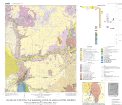
COVERAGE NAME: tepk_geol
----------------------------------------------------------------------------

DATABASE STRUCTURE OF TEPK_GEOL.PAT:

COLUMN   ITEM NAME        WIDTH OUTPUT  TYPE N.DEC  ALTERNATE NAME     INDEXED?
    1  AREA                   8    18     F      5                        -
    9  PERIMETER              8    18     F      5                        -
   17  TEPK_GEOL#             4     5     B      -                        -
   21  TEPK_GEOL-ID           4     5     B      -                        -
   25  LABEL                 10    10     C      -                        -
   35  SUPPRESS               4     4     C      -                        -
   39  SYMBOL                 4     4     N      0                        -
   43  CINDER                 4     5     B      -                        -
   47  DESCRIPTION	      57    57     C      -                        -

ATTRIBUTE NAME: LABEL
DESCRIPTION: Geologic unit labels
ITEM VALUES FOR 'LABEL':
LABEL  SYMBOL   DESCRIPTION
------------------------------------------------------------------------
af      524      Artificial fill deposits
Qal      14      Flood plain and stream channel deposits
Qac      12      Alluvium and colluvium, undivided
Qfd      20      Fan alluvium and debris-flow deposits
Qf       28      Fan alluvium
Qc      516      Colluvium, undivided
Qd       13      Debris-flow deposits
Qsw      32      Sheetwash deposits
Qls      30      Landslide deposits
Qt        5      Terrace alluvium
QTa      43      Ancha Formation
Qp       25      Pediment deposits
QTs      64      Upper Santa Fe Group sediments
Tby     195      Younger basalt of Caja del Rio
Tbr     200      Basalt of Caja del Rio
Tdt     207      Dacite of Tetilla Peak
Tat     203      Andesite of Tetilla Peak
Tbs     199      Basalt of Tsinat Mesa
Tbj     168      Basalt of Mesita de Juana
Tbb     172      Basalt of La Bajada
Tc      292      Cieneguilla Basanite
Te      147      Espinaso Formation
Tbd     287      Basaltic dikes
Tmi     129      Monzonite and monzonite porphyry intrusions
Tmh     125      Hornblende monzonite porphyry intrusions
Tsp      72      Santa Fe Group--eastern piedmont facies
Tab     131      Abiquiu Formation
Tg       57      Galisteo Formation
Kmn     441      Mancos Shale, Niobrara Member
Kmj     423      Mancos Shale, Juana Lopez Member, and Blue Hill and
Fairport Members of the Carlile Shale, undivided
Kmb     433      Mancos Shale, Bridge Creek Limestone and Graneros
Members, undivided
Kmd     470      Mancos Shale and Dakota Sandstone, undivided
Kdc     430      Dakota Sandstone, Cubero Tongue
Kdo     424      Dakota Sandstone, Oak Canyon Member
Jmj     359      Morrison Formation, Jackpile Sandstone Member
Jmb     354      Morrison Formation, Brushy Basin Member
Jmw     355      Morrison Formation, Westwater Canyon Member
Jwb     341      Wanakah Formation, Beclabito Member
Jt      345      Todilto Formation
Je      356      Entrada Sandstone
TRc     349      Chinle Formation

ATTRIBUTE NAME: SUPPRESS
DESCRIPTION: flag to suppress printing of unit labels in small polygons
ITEM VALUES FOR 'SUPPRESS':
yes

ATTRIBUTE NAME: SYMBOL
DESCRIPTION: value of shadesymbol (in shadeset color524.shd) used to color geology polygons
ITEM VALUES FOR 'SYMBOL':
see table of values above

ATTRIBUTE NAME: CINDER
DESCRIPTION: Flag to draw cross-hatch pattern on selected geologic units
ITEM VALUES FOR 'CINDER':
0  do not draw pattern
1  draw cross-hatch pattern


DATABASE STRUCTURE OF TEPK_GEOL.AAT:

COLUMN   ITEM NAME        WIDTH OUTPUT  TYPE N.DEC  ALTERNATE NAME     INDEXED?
    1  FNODE#                 4     5     B      -                        -
    5  TNODE#                 4     5     B      -                        -
    9  LPOLY#                 4     5     B      -                        -
   13  RPOLY#                 4     5     B      -                        -
   17  LENGTH                 8    18     F      5                        -
   25  TEPK_GEOL#             4     5     B      -                        -
   29  TEPK_GEOL-ID           4     5     B      -                        -
   33  DESCRIPTION           25    25     C      -                        -
   58  SYMBOL                 4     4     I      -                        -


ATTRIBUTE NAME: DESCRIPTION
DESCRIPTION: type of line
ITEM VALUES FOR 'DESCRIPTION':
DESCRIPTION            SYMBOL
------------------------------
syncline - concealed   95
anticline -certain     60
border                 5
fault - concealed      149
Tbd dike - certain         402
Tmi dike - certain         202
fault - certain        102
flow contact           406
pit or quarry          15
contact - certain      1

ATTRIBUTE NAME: SYMBOL
DESCRIPTION: line symbols (in carto.lin, geol_sfo.lin, and geoscamp1.lin) used to draw lines
ITEM VALUES FOR 'SYMBOL':
see table of values above

----------------------------------------------------------------------------
COVERAGE NAME: tepk_bed
----------------------------------------------------------------------------

DATABASE STRUCTURE OF TEPK_BED.PAT:

COLUMN   ITEM NAME        WIDTH OUTPUT  TYPE N.DEC  ALTERNATE NAME     INDEXED?
    1  AREA                   8    18     F      5                        -
    9  PERIMETER              8    18     F      5                        -
   17  TEPK_BED#              4     5     B      -                        -
   21  TEPK_BED-ID            4     5     B      -                        -
   25  AZIMUTH                8    10     F      0                        -
   33  DIP                    4     4     B      -                        -
   37  STATION                8     8     C      -                        -
   45  SYMBOL                 8     8     I      -                        -
   53  SUPPRESS               5     5     C      -                        -


ATTRIBUTE NAME: AZIMUTH
DESCRIPTION: compass direction of bedding trend, in degrees
ITEM VALUES FOR 'AZIMUTH':
Range of values: 0 - 360

ATTRIBUTE NAME: DIP
DESCRIPTION: angle of bedding dip, in degrees from horizontal
ITEM VALUES FOR 'DIP':
range of values: 0 - 90

ATTRIBUTE NAME: STATION
DESCRIPTION: unique identifier assigned to location at which measurement was taken
ITEM VALUES FOR 'STATION':
DTPB01
DTPB02
DTPB03
DTPB04
DTPB05
DTPB06
DTPB07
DTPB08
DTPB09
DTPB10
DTPB100
DTPB102
DTPB103
DTPB104
DTPB105
DTPB106
DTPB107
DTPB108
DTPB109
DTPB11
DTPB110
DTPB111
DTPB112
DTPB113
DTPB114
DTPB115
DTPB116
DTPB117
DTPB118
DTPB119
DTPB12
DTPB120
DTPB121
DTPB122
DTPB13
DTPB14
DTPB15
DTPB16
DTPB17
DTPB18
DTPB19
DTPB20
DTPB84
DTPB85
DTPB87
DTPB88
DTPB89
DTPB90
DTPB91
DTPB92
DTPB93
DTPB94
DTPB95
DTPB96
DTPB97
DTPB98
DTPB99
SM96-10
SM96-13
SM96-15
SM96-17
SM96-18
SM96-21
SM96-22
SM96-32
SM96-33
SM96-34
SM96-35
SM96-37
SM96-39
SM96-41
SM96-42
SM96-43
SM96-44
SM96-46
SM96-47
SM96-48
SM96-50
SM96-51
SM96-56
SM96-57
SM96-8
SM96-9
SM9616a
SM9616b
SM9622a
SM96bd01
SM96bd02
SM96bd03
SM96bd04
SM96bd05
SM96bd06
SM96bd08
SM96bd09
SM96bd10
SM96bd11
SM96bd12
SM96bd13
SM96bd14
SM96bd15
SM96bd17
SM96bd18
SM96bd19
SM96bd20
bd84
bd85
bd86

ATTRIBUTE NAME: SYMBOL
DESCRIPTION: value of symbol (in markerset geoscamp1.mrk) used to plot points
ITEM VALUES FOR 'SYMBOL':
2
6

ATTRIBUTE NAME: SUPPRESS
: flag indicating whether to show points on map (plot points if suppress = no)
ITEM VALUES FOR 'SUPPRESS':
yes

----------------------------------------------------------------------------
COVERAGE NAME: tepk_struct
----------------------------------------------------------------------------

DATABASE STRUCTURE OF TEPK_STRUCT.PAT:

COLUMN   ITEM NAME        WIDTH OUTPUT  TYPE N.DEC  ALTERNATE NAME     INDEXED?
    1  AREA                   8    18     F      5                        -
    9  PERIMETER              8    18     F      5                        -
   17  TEPK_FAULT#            4     5     B      -                        -
   21  TEPK_FAULT-ID          4     5     B      -                        -
   25  STATION                9     9     C      -                        -
   34  SCALE__TYP            13    13     C      -                        -
   47  CERT_SLPS             11    11     C      -                        -
   58  AZIMUTH                8    12     F      0                        -
   66  DIP                    9     9     C      -                        -
   75  DIP_DIRCTN             5     5     I      -                        -
   80  RAKE1                  9     9     C      -                        -
   89  RAKE2                  9     9     C      -                        -
   98  LIN_TREND              5     5     I      -                        -
  103  LIN_PLUNGE             5     5     I      -                        -
  108  SYMBOL                 8     8     I      -                        -
  116  SUPPRESS               5     5     C      -                        -


ATTRIBUTE NAME: STATION
DESCRIPTION: unique identifier assigned to location at which measurement was taken
ITEM VALUES FOR 'STATION':
96-10
96-12
96-14
96-15
96-16
96-17
96-18
96-19
96-3
96-32
96-33
96-34
96-35
96-36
96-37
96-38
96-39
96-4
96-40
96-42
96-43
96-44
96-46
96-47
96-48
96-5
96-50
96-51
96-55
96-56
96-57
96-8
96-9

ATTRIBUTE NAME: SCALE_TYP
DESCRIPTION: Type of fault observation made
ITEM VALUES FOR 'SCALE_TYP':
SCALE_TYP       DESCRIPTION
---------------------------------------
mapflt		map-scale fault plane
meso		mesoscale fault plane
dragfl		drag fold
joint		joint
dike		mesoscale dike
mapdike	map-scale dike


ATTRIBUTE NAME: CERT_SLPS
DESCRIPTION: Slip-sense code for fault
ITEM VALUES FOR 'CERT_SLPS':
----- RAKE -----
<45 deg  >45 deg    DEFINITION
--------------------------------------------------
  CN       CS       certainly normal-sinistral slip
  PN       PS       probably normal-sinistral slip
  SN                possibly normal-sinistral slip
  CN       CD       certainly normal-dextral slip
  PN                probably normal-dextral slip
  SN                possibly normal-dextral slip

ATTRIBUTE NAME: AZIMUTH
DESCRIPTION: compass direction of fault plane trend, in degrees
ITEM VALUES FOR 'AZIMUTH':
Range of values: 0 - 360

ATTRIBUTE NAME: DIP
DESCRIPTION: angle of fault plane dip, in degrees from horizontal
ITEM VALUES FOR 'DIP':
range of values: 0 - 90

ATTRIBUTE NAME: DIP_DIRCTN
DESCRIPTION: compass direction of fault plane dip, in degrees
ITEM VALUES FOR 'DIP_DIRCTN':
Range of values: 0 - 360


ATTRIBUTE NAME: RAKE1
DESCRIPTION: Primary fault slickenline rake, degrees and compass direction
ITEM VALUES FOR 'RAKE1':
integer values between 0 and 90 degrees with letter designating direction (N,E,W, or S)

ATTRIBUTE NAME: RAKE2
DESCRIPTION: Secondary or younger fault slickenline rake, degrees and compass direction
ITEM VALUES FOR 'RAKE2':
integer values between 0 and 90 degrees with letter designating direction (N,E,W, or S)

ATTRIBUTE NAME: LIN_TREND
DESCRIPTION: Trend (compass direction) of primary slickenlines, in degrees
ITEM VALUES FOR 'LIN_TREND':
Range of values: 0 - 360


ATTRIBUTE NAME: LIN_PLUNGE
DESCRIPTION: Plunge of primary slickenlines, in degrees from horizontal
ITEM VALUES FOR 'LIN_PLUNGE':
Range of values: 0 - 90

ATTRIBUTE NAME: SYMBOL
DESCRIPTION: value of markersymbol (in geoscamp1.mrk) used to plot map symbol
ITEM VALUES FOR 'SYMBOL':
0
105
106
181

ATTRIBUTE NAME: SUPPRESS
DESCRIPTION: flag indicating whether to plot data point at map scale (plot if suppress not equal to yes)
ITEM VALUES FOR 'SUPPRESS':
yes

----------------------------------------------------------------------------
COVERAGE NAME: tepk_chem
----------------------------------------------------------------------------

DATABASE STRUCTURE OF TEPK_CHEM.PAT:

COLUMN   ITEM NAME        WIDTH OUTPUT  TYPE N.DEC  ALTERNATE NAME     INDEXED?
    1  AREA                   8    18     F      5                        -
    9  PERIMETER              8    18     F      5                        -
   17  TEPK_CHEM#             4     5     B      -                        -
   21  TEPK_CHEM-ID           4     5     B      -                        -
   25  GEOLOGY               10    10     C      -                        -
   35  AGE                    9     9     C      -                        -
   44  AGE_UNCERT            14    14     C      -                        -
   58  SMPL_TYPE             12    12     C      -                        -
   70  SYMBOL                 8    10     F      0                        -
   78  STATION               11    11     C      -                        -


ATTRIBUTE NAME: GEOLOGY
DESCRIPTION:  Unit abbreviation for geologic unit in which sample was collected
ITEM VALUES FOR 'GEOLOGY':
see "LABEL" item in coverage "tepk_geol"

ATTRIBUTE NAME: AGE
DESCRIPTION: Age of sample, in Ma
ITEM VALUES FOR 'AGE':
real numbers in the range 2.03 - 3.04

ATTRIBUTE NAME: AGE_UNCERT
DESCRIPTION: Uncertainty of age determination +/-, in Ma
ITEM VALUES FOR 'AGE_UNCERT':
real numbers in the range 0.03 - 0.35

ATTRIBUTE NAME: SMPL_TYPE
DESCRIPTION: Type of sample determination
ITEM VALUES FOR 'SMPL_TYPE':
AR      Ar-40/Ar-39 age determination
C       Whole-rock chemistry
K-AR    K-40/Ar-39 age determination

ATTRIBUTE NAME: SYMBOL
DESCRIPTION: Markersymbol (in oilgas.mrk) used to plot data on map
ITEM VALUES FOR 'SYMBOL':
102
127
238

ATTRIBUTE NAME: STATION
DESCRIPTION: unique identifier assigned to sample and location
ITEM VALUES FOR 'STATION':
58BTP142
58BTP162
58BTP48
58BTP49
58BTP84
58BTP85
79STPA71
79ZTP04
79ZTP05
79ZTP10
96DTP01
96DTP02
96DTP03
96DTP04
96DTP05
96DTP06
96DTP07
96DTP08
96DTP09
96DTP10
96DTP11
96DTP12
96DTP13
96DTP14
96DTP15
96DTP19
96DTP24
96DTP30
96DTP34
96TTP01
97DTP101
97DTP88
97DTP91
97DTP96
97DTP97
97DTP98A
97DTP99
BachMen20
SM96-49

----------------------------------------------------------------------------
COVERAGE NAME: tepk_amt
----------------------------------------------------------------------------

DATABASE STRUCTURE OF TEPK_AMT.PAT:

COLUMN   ITEM NAME        WIDTH OUTPUT  TYPE N.DEC  ALTERNATE NAME     INDEXED?
    1  AREA                   8    18     F      5                        -
    9  PERIMETER              8    18     F      5                        -
   17  TEPK_AMT#              4     5     B      -                        -
   21  TEPK_AMT-ID            4     5     B      -                        -
   25  STATION               13    14     C      -                        -


ATTRIBUTE NAME: STATION
DESCRIPTION: unique identifier assigned to location of data collection
ITEM VALUES FOR 'STATION':
AMT-4

----------------------------------------------------------------------------
COVERAGE NAME: tepk_wells
----------------------------------------------------------------------------

DATABASE STRUCTURE OF TEPK_WELLS.PAT:

COLUMN   ITEM NAME        WIDTH OUTPUT  TYPE N.DEC  ALTERNATE NAME     INDEXED?
    1  AREA                   4    12     F      3                        -
    5  PERIMETER              4    12     F      3                        -
    9  TEPK_WELLS#            4     5     B      -                        -
   13  TEPK_WELLS-ID          4     5     B      -                        -
   17  WELL_NAME             26    26     C      -                        -


ATTRIBUTE NAME: WELL_NAME
DESCRIPTION: Text identification of well type and location
ITEM VALUES FOR 'WELL_NAME':
Eight Hundred Foot Well
Cochiti-T Windmill


-----------------------------------------------
COVERAGE NAME:	tepk_marker
-----------------------------------------------

DATABASE STRUCTURE OF TEPK_MARKER.PAT

COLUMN   ITEM NAME           WIDTH  OUTPUT  TYPE N.DEC  ALTERNATE NAME    INDEXED?
  1	 AREA		          8      18     F     5                        -
  9     PERIMETER                8      18     F     5                        -
  17    TEPK_MARKER#             4       5     B     -                        -
  21    TEPK_MARKER-ID           4       5     B     -                        -
  25    ANGEL                    4       4     N     0                        -
  29    MARKER                   4       4     I     -                        -

ATTRIBUTE NAME: ANGLE
DESCRIPTION: rotation angle of decoration symbol
range of values: 0 - 360

ATTRIBUTE NAME: MARKER
DESCRIPTION: value of markersymbol
135
190
191
192
Entity_and_Attribute_Detail_Citation: http://pubs.usgs.gov/mf/2002/mf-2352/mf-2352_pam.pdf
Distribution_Information:
Distributor:
Contact_Information:
Contact_Organization_Primary:
Contact_Organization: U.S. Geological Survey
Contact_Address:
Address_Type: mailing address
Address:
Central Publications Group
MS 902, Box 25046 Denver Federal Center
City: Lakewood
State_or_Province: CO
Postal_Code: 80225-0046
Contact_Voice_Telephone: 303-236-5486
Distribution_Liability:
Although these digital spatial data have been subjected to rigorous review and are substantially complete, it is released on the condition that neither the USGS nor the United States Government may be held liable for any damages resulting from their authorized or unauthorized use.
Standard_Order_Process:
Digital_Form:
Digital_Transfer_Information:
Format_Name: ARCE, Shapefile
Format_Version_Number: 8.1
File_Decompression_Technique: GZIP compressed TAR file (Unix), ZIP archive (Windows)
Digital_Transfer_Option:
Online_Option:
Computer_Contact_Information:
Network_Address:
Fees: none
Metadata_Reference_Information:
Metadata_Date: 20160613
Metadata_Contact:
Contact_Information:
Contact_Person_Primary:
Contact_Person: Peter N Schweitzer
Contact_Organization: USGS Midwest Area
Contact_Position:
Collection manager, USGS Geoscience Data Clearinghouse, http://geo-nsdi.er.usgs.gov/
Contact_Address:
Address_Type: mailing address
Address:
Mail Stop 954
12201 Sunrise Valley Dr
City: Reston
State_or_Province: VA
Postal_Code: 20192-0002
Country: USA
Contact_Voice_Telephone: 703-648-6533
Contact_Facsimile_Telephone: 703-648-6252
Contact_Electronic_Mail_Address: pschweitzer@usgs.gov
Metadata_Standard_Name: Content Standard for Digital Geospatial Metadata
Metadata_Standard_Version: FGDC-STD-001-1998
Metadata_Access_Constraints: none
Metadata_Use_Constraints: none

This page is <https://geo-nsdi.er.usgs.gov/metadata/map-mf/2352/metadata.html>
Generated by mp version 2.9.48 on Tue Jul 03 20:05:05 2018