tepk_geol:           geologic units, faults, dikes, volcanic flow boundaries
tepk_struct:         bearing and attitude measurements of structural features
tepk_bed:            attitude measurements of geologic units
tepk_chem:           geochemical and geochronologic data by sample
tepk_amt:            audio-magneto-telluric (AMT) geophysical sample data
tepk_wells:          water well locations
tepk_marker:         cartographic decorations (bar and ball symbol, etc.)
color524.shd:        ArcInfo shadeset used to color geology polygons
geoscamp1.mrk:       ArcInfo markerset used to plot geologic symbols
geoscamp1.lin:       ArcInfo lineset used to plot geologic line symbols
tepk_base.tif,.tfw:  1:24,000-scale topographic base
Online Links:
----------------------------------------------------------------------------
COVERAGE NAME: tepk_geol
----------------------------------------------------------------------------

DATABASE STRUCTURE OF TEPK_GEOL.PAT:

COLUMN   ITEM NAME        WIDTH OUTPUT  TYPE N.DEC  ALTERNATE NAME     INDEXED?
    1  AREA                   8    18     F      5                        -
    9  PERIMETER              8    18     F      5                        -
   17  TEPK_GEOL#             4     5     B      -                        -
   21  TEPK_GEOL-ID           4     5     B      -                        -
   25  LABEL                 10    10     C      -                        -
   35  SUPPRESS               4     4     C      -                        -
   39  SYMBOL                 4     4     N      0                        -
   43  CINDER                 4     5     B      -                        -
   47  DESCRIPTION	      57    57     C      -                        -

ATTRIBUTE NAME: LABEL
DESCRIPTION: Geologic unit labels
ITEM VALUES FOR 'LABEL':
LABEL  SYMBOL   DESCRIPTION
------------------------------------------------------------------------
af      524      Artificial fill deposits
Qal      14      Flood plain and stream channel deposits
Qac      12      Alluvium and colluvium, undivided
Qfd      20      Fan alluvium and debris-flow deposits
Qf       28      Fan alluvium
Qc      516      Colluvium, undivided
Qd       13      Debris-flow deposits
Qsw      32      Sheetwash deposits
Qls      30      Landslide deposits
Qt        5      Terrace alluvium
QTa      43      Ancha Formation
Qp       25      Pediment deposits
QTs      64      Upper Santa Fe Group sediments
Tby     195      Younger basalt of Caja del Rio
Tbr     200      Basalt of Caja del Rio
Tdt     207      Dacite of Tetilla Peak
Tat     203      Andesite of Tetilla Peak
Tbs     199      Basalt of Tsinat Mesa
Tbj     168      Basalt of Mesita de Juana
Tbb     172      Basalt of La Bajada
Tc      292      Cieneguilla Basanite
Te      147      Espinaso Formation
Tbd     287      Basaltic dikes
Tmi     129      Monzonite and monzonite porphyry intrusions
Tmh     125      Hornblende monzonite porphyry intrusions
Tsp      72      Santa Fe Group--eastern piedmont facies
Tab     131      Abiquiu Formation
Tg       57      Galisteo Formation
Kmn     441      Mancos Shale, Niobrara Member
Kmj     423      Mancos Shale, Juana Lopez Member, and Blue Hill and
Fairport Members of the Carlile Shale, undivided
Kmb 433 Mancos Shale, Bridge Creek Limestone and GranerosMembers, undivided
Kmd     470      Mancos Shale and Dakota Sandstone, undivided
Kdc     430      Dakota Sandstone, Cubero Tongue
Kdo     424      Dakota Sandstone, Oak Canyon Member
Jmj     359      Morrison Formation, Jackpile Sandstone Member
Jmb     354      Morrison Formation, Brushy Basin Member
Jmw     355      Morrison Formation, Westwater Canyon Member
Jwb     341      Wanakah Formation, Beclabito Member
Jt      345      Todilto Formation
Je      356      Entrada Sandstone
TRc     349      Chinle Formation

ATTRIBUTE NAME: SUPPRESS
DESCRIPTION: flag to suppress printing of unit labels in small polygons
ITEM VALUES FOR 'SUPPRESS':
yes

ATTRIBUTE NAME: SYMBOL
DESCRIPTION: value of shadesymbol (in shadeset color524.shd) used to color geology polygons
ITEM VALUES FOR 'SYMBOL':
see table of values above

ATTRIBUTE NAME: CINDER
DESCRIPTION: Flag to draw cross-hatch pattern on selected geologic units
ITEM VALUES FOR 'CINDER':
0  do not draw pattern
1  draw cross-hatch pattern


DATABASE STRUCTURE OF TEPK_GEOL.AAT:

COLUMN   ITEM NAME        WIDTH OUTPUT  TYPE N.DEC  ALTERNATE NAME     INDEXED?
    1  FNODE#                 4     5     B      -                        -
    5  TNODE#                 4     5     B      -                        -
    9  LPOLY#                 4     5     B      -                        -
   13  RPOLY#                 4     5     B      -                        -
   17  LENGTH                 8    18     F      5                        -
   25  TEPK_GEOL#             4     5     B      -                        -
   29  TEPK_GEOL-ID           4     5     B      -                        -
   33  DESCRIPTION           25    25     C      -                        -
   58  SYMBOL                 4     4     I      -                        -


ATTRIBUTE NAME: DESCRIPTION
DESCRIPTION: type of line
ITEM VALUES FOR 'DESCRIPTION':
DESCRIPTION            SYMBOL
------------------------------
syncline - concealed   95
anticline -certain     60
border                 5
fault - concealed      149
Tbd dike - certain         402
Tmi dike - certain         202
fault - certain        102
flow contact           406
pit or quarry          15
contact - certain      1

ATTRIBUTE NAME: SYMBOL
DESCRIPTION: line symbols (in carto.lin, geol_sfo.lin, and geoscamp1.lin) used to draw lines
ITEM VALUES FOR 'SYMBOL':
see table of values above

----------------------------------------------------------------------------
COVERAGE NAME: tepk_bed
----------------------------------------------------------------------------

DATABASE STRUCTURE OF TEPK_BED.PAT:

COLUMN   ITEM NAME        WIDTH OUTPUT  TYPE N.DEC  ALTERNATE NAME     INDEXED?
    1  AREA                   8    18     F      5                        -
    9  PERIMETER              8    18     F      5                        -
   17  TEPK_BED#              4     5     B      -                        -
   21  TEPK_BED-ID            4     5     B      -                        -
   25  AZIMUTH                8    10     F      0                        -
   33  DIP                    4     4     B      -                        -
   37  STATION                8     8     C      -                        -
   45  SYMBOL                 8     8     I      -                        -
   53  SUPPRESS               5     5     C      -                        -


ATTRIBUTE NAME: AZIMUTH
DESCRIPTION: compass direction of bedding trend, in degrees
ITEM VALUES FOR 'AZIMUTH':
Range of values: 0 - 360

ATTRIBUTE NAME: DIP
DESCRIPTION: angle of bedding dip, in degrees from horizontal
ITEM VALUES FOR 'DIP':
range of values: 0 - 90

ATTRIBUTE NAME: STATION
DESCRIPTION: unique identifier assigned to location at which measurement was taken
ITEM VALUES FOR 'STATION':
DTPB01
DTPB02
DTPB03
DTPB04
DTPB05
DTPB06
DTPB07
DTPB08
DTPB09
DTPB10
DTPB100
DTPB102
DTPB103
DTPB104
DTPB105
DTPB106
DTPB107
DTPB108
DTPB109
DTPB11
DTPB110
DTPB111
DTPB112
DTPB113
DTPB114
DTPB115
DTPB116
DTPB117
DTPB118
DTPB119
DTPB12
DTPB120
DTPB121
DTPB122
DTPB13
DTPB14
DTPB15
DTPB16
DTPB17
DTPB18
DTPB19
DTPB20
DTPB84
DTPB85
DTPB87
DTPB88
DTPB89
DTPB90
DTPB91
DTPB92
DTPB93
DTPB94
DTPB95
DTPB96
DTPB97
DTPB98
DTPB99
SM96-10
SM96-13
SM96-15
SM96-17
SM96-18
SM96-21
SM96-22
SM96-32
SM96-33
SM96-34
SM96-35
SM96-37
SM96-39
SM96-41
SM96-42
SM96-43
SM96-44
SM96-46
SM96-47
SM96-48
SM96-50
SM96-51
SM96-56
SM96-57
SM96-8
SM96-9
SM9616a
SM9616b
SM9622a
SM96bd01
SM96bd02
SM96bd03
SM96bd04
SM96bd05
SM96bd06
SM96bd08
SM96bd09
SM96bd10
SM96bd11
SM96bd12
SM96bd13
SM96bd14
SM96bd15
SM96bd17
SM96bd18
SM96bd19
SM96bd20
bd84
bd85
bd86

ATTRIBUTE NAME: SYMBOL
DESCRIPTION: value of symbol (in markerset geoscamp1.mrk) used to plot points
ITEM VALUES FOR 'SYMBOL':
2
6

ATTRIBUTE NAME: SUPPRESS
: flag indicating whether to show points on map (plot points if suppress = no)
ITEM VALUES FOR 'SUPPRESS':
yes

----------------------------------------------------------------------------
COVERAGE NAME: tepk_struct
----------------------------------------------------------------------------

DATABASE STRUCTURE OF TEPK_STRUCT.PAT:

COLUMN   ITEM NAME        WIDTH OUTPUT  TYPE N.DEC  ALTERNATE NAME     INDEXED?
    1  AREA                   8    18     F      5                        -
    9  PERIMETER              8    18     F      5                        -
   17  TEPK_FAULT#            4     5     B      -                        -
   21  TEPK_FAULT-ID          4     5     B      -                        -
   25  STATION                9     9     C      -                        -
   34  SCALE__TYP            13    13     C      -                        -
   47  CERT_SLPS             11    11     C      -                        -
   58  AZIMUTH                8    12     F      0                        -
   66  DIP                    9     9     C      -                        -
   75  DIP_DIRCTN             5     5     I      -                        -
   80  RAKE1                  9     9     C      -                        -
   89  RAKE2                  9     9     C      -                        -
   98  LIN_TREND              5     5     I      -                        -
  103  LIN_PLUNGE             5     5     I      -                        -
  108  SYMBOL                 8     8     I      -                        -
  116  SUPPRESS               5     5     C      -                        -


ATTRIBUTE NAME: STATION
DESCRIPTION: unique identifier assigned to location at which measurement was taken
ITEM VALUES FOR 'STATION':
96-10
96-12
96-14
96-15
96-16
96-17
96-18
96-19
96-3
96-32
96-33
96-34
96-35
96-36
96-37
96-38
96-39
96-4
96-40
96-42
96-43
96-44
96-46
96-47
96-48
96-5
96-50
96-51
96-55
96-56
96-57
96-8
96-9

ATTRIBUTE NAME: SCALE_TYP
DESCRIPTION: Type of fault observation made
ITEM VALUES FOR 'SCALE_TYP':
SCALE_TYP       DESCRIPTION
---------------------------------------
mapflt		map-scale fault plane
meso		mesoscale fault plane
dragfl		drag fold
joint		joint
dike		mesoscale dike
mapdike	map-scale dike


ATTRIBUTE NAME: CERT_SLPS
DESCRIPTION: Slip-sense code for fault
ITEM VALUES FOR 'CERT_SLPS':
----- RAKE -----
<45 deg  >45 deg    DEFINITION
--------------------------------------------------
  CN       CS       certainly normal-sinistral slip
  PN       PS       probably normal-sinistral slip
  SN                possibly normal-sinistral slip
  CN       CD       certainly normal-dextral slip
  PN                probably normal-dextral slip
  SN                possibly normal-dextral slip

ATTRIBUTE NAME: AZIMUTH
DESCRIPTION: compass direction of fault plane trend, in degrees
ITEM VALUES FOR 'AZIMUTH':
Range of values: 0 - 360

ATTRIBUTE NAME: DIP
DESCRIPTION: angle of fault plane dip, in degrees from horizontal
ITEM VALUES FOR 'DIP':
range of values: 0 - 90

ATTRIBUTE NAME: DIP_DIRCTN
DESCRIPTION: compass direction of fault plane dip, in degrees
ITEM VALUES FOR 'DIP_DIRCTN':
Range of values: 0 - 360


ATTRIBUTE NAME: RAKE1
DESCRIPTION: Primary fault slickenline rake, degrees and compass direction
ITEM VALUES FOR 'RAKE1':
integer values between 0 and 90 degrees with letter designating direction (N,E,W, or S)

ATTRIBUTE NAME: RAKE2
DESCRIPTION: Secondary or younger fault slickenline rake, degrees and compass direction
ITEM VALUES FOR 'RAKE2':
integer values between 0 and 90 degrees with letter designating direction (N,E,W, or S)

ATTRIBUTE NAME: LIN_TREND
DESCRIPTION: Trend (compass direction) of primary slickenlines, in degrees
ITEM VALUES FOR 'LIN_TREND':
Range of values: 0 - 360


ATTRIBUTE NAME: LIN_PLUNGE
DESCRIPTION: Plunge of primary slickenlines, in degrees from horizontal
ITEM VALUES FOR 'LIN_PLUNGE':
Range of values: 0 - 90

ATTRIBUTE NAME: SYMBOL
DESCRIPTION: value of markersymbol (in geoscamp1.mrk) used to plot map symbol
ITEM VALUES FOR 'SYMBOL':
0
105
106
181

ATTRIBUTE NAME: SUPPRESS
DESCRIPTION: flag indicating whether to plot data point at map scale (plot if suppress not equal to yes)
ITEM VALUES FOR 'SUPPRESS':
yes

----------------------------------------------------------------------------
COVERAGE NAME: tepk_chem
----------------------------------------------------------------------------

DATABASE STRUCTURE OF TEPK_CHEM.PAT:

COLUMN   ITEM NAME        WIDTH OUTPUT  TYPE N.DEC  ALTERNATE NAME     INDEXED?
    1  AREA                   8    18     F      5                        -
    9  PERIMETER              8    18     F      5                        -
   17  TEPK_CHEM#             4     5     B      -                        -
   21  TEPK_CHEM-ID           4     5     B      -                        -
   25  GEOLOGY               10    10     C      -                        -
   35  AGE                    9     9     C      -                        -
   44  AGE_UNCERT            14    14     C      -                        -
   58  SMPL_TYPE             12    12     C      -                        -
   70  SYMBOL                 8    10     F      0                        -
   78  STATION               11    11     C      -                        -


ATTRIBUTE NAME: GEOLOGY
DESCRIPTION:  Unit abbreviation for geologic unit in which sample was collected
ITEM VALUES FOR 'GEOLOGY':
see "LABEL" item in coverage "tepk_geol"

ATTRIBUTE NAME: AGE
DESCRIPTION: Age of sample, in Ma
ITEM VALUES FOR 'AGE':
real numbers in the range 2.03 - 3.04

ATTRIBUTE NAME: AGE_UNCERT
DESCRIPTION: Uncertainty of age determination +/-, in Ma
ITEM VALUES FOR 'AGE_UNCERT':
real numbers in the range 0.03 - 0.35

ATTRIBUTE NAME: SMPL_TYPE
DESCRIPTION: Type of sample determination
ITEM VALUES FOR 'SMPL_TYPE':
AR      Ar-40/Ar-39 age determination
C       Whole-rock chemistry
K-AR    K-40/Ar-39 age determination

ATTRIBUTE NAME: SYMBOL
DESCRIPTION: Markersymbol (in oilgas.mrk) used to plot data on map
ITEM VALUES FOR 'SYMBOL':
102
127
238

ATTRIBUTE NAME: STATION
DESCRIPTION: unique identifier assigned to sample and location
ITEM VALUES FOR 'STATION':
58BTP142
58BTP162
58BTP48
58BTP49
58BTP84
58BTP85
79STPA71
79ZTP04
79ZTP05
79ZTP10
96DTP01
96DTP02
96DTP03
96DTP04
96DTP05
96DTP06
96DTP07
96DTP08
96DTP09
96DTP10
96DTP11
96DTP12
96DTP13
96DTP14
96DTP15
96DTP19
96DTP24
96DTP30
96DTP34
96TTP01
97DTP101
97DTP88
97DTP91
97DTP96
97DTP97
97DTP98A
97DTP99
BachMen20
SM96-49

----------------------------------------------------------------------------
COVERAGE NAME: tepk_amt
----------------------------------------------------------------------------

DATABASE STRUCTURE OF TEPK_AMT.PAT:

COLUMN   ITEM NAME        WIDTH OUTPUT  TYPE N.DEC  ALTERNATE NAME     INDEXED?
    1  AREA                   8    18     F      5                        -
    9  PERIMETER              8    18     F      5                        -
   17  TEPK_AMT#              4     5     B      -                        -
   21  TEPK_AMT-ID            4     5     B      -                        -
   25  STATION               13    14     C      -                        -


ATTRIBUTE NAME: STATION
DESCRIPTION: unique identifier assigned to location of data collection
ITEM VALUES FOR 'STATION':
AMT-4

----------------------------------------------------------------------------
COVERAGE NAME: tepk_wells
----------------------------------------------------------------------------

DATABASE STRUCTURE OF TEPK_WELLS.PAT:

COLUMN   ITEM NAME        WIDTH OUTPUT  TYPE N.DEC  ALTERNATE NAME     INDEXED?
    1  AREA                   4    12     F      3                        -
    5  PERIMETER              4    12     F      3                        -
    9  TEPK_WELLS#            4     5     B      -                        -
   13  TEPK_WELLS-ID          4     5     B      -                        -
   17  WELL_NAME             26    26     C      -                        -


ATTRIBUTE NAME: WELL_NAME
DESCRIPTION: Text identification of well type and location
ITEM VALUES FOR 'WELL_NAME':
Eight Hundred Foot Well
Cochiti-T Windmill


-----------------------------------------------
COVERAGE NAME:	tepk_marker
-----------------------------------------------

DATABASE STRUCTURE OF TEPK_MARKER.PAT

COLUMN   ITEM NAME           WIDTH  OUTPUT  TYPE N.DEC  ALTERNATE NAME    INDEXED?
  1	 AREA		          8      18     F     5                        -
  9     PERIMETER                8      18     F     5                        -
  17    TEPK_MARKER#             4       5     B     -                        -
  21    TEPK_MARKER-ID           4       5     B     -                        -
  25    ANGEL                    4       4     N     0                        -
  29    MARKER                   4       4     I     -                        -

ATTRIBUTE NAME: ANGLE
DESCRIPTION: rotation angle of decoration symbol
range of values: 0 - 360

ATTRIBUTE NAME: MARKER
DESCRIPTION: value of markersymbol
135
190
191
192
Production of this map was funded by the National Cooperative Geologic Mapping Program. Thanks are given to John S. Pallister, Program Coordinator. Permission from the Governor's and council of Pueblo de Cochiti is gratefully acknowledged. Jacob Pecos, Gary Valdo, Dave Gordon, Michael Quintana, and Lee Suina of the Cochiti Environmental Protection Office (CEPO) rendered critical input and graciously provided cooperative assistance; Donald Suina of the Cochiti Game and Fish Department oversaw the safety and security of work conducted on Pueblo de Cochiti lands. Don Diego Gonzales facilitated interaction with the Pueblo de Cochiti and supported interactions with the Pueblo and essential cooperative training. Without the pioneering work of John W. Hawley and J. Michael Kernoodle, or the cooperation and leadership of Charles E. Chapin of the New Mexico Bureau of Mines and Mineral Resources, we would not even have conceived of the work focused on hydrogeologic problems in the "Middle Rio Grande."
Collegial interactions with Gary A. Smith of the University of New Mexico and David P. Dethier of Williams College have kept us honest and furthered our collective work; complete reviews by Dethier, Paul S. Williams, Tom Judkins, and Alex Donatich and partial reviews by William A. Cobban, Steve Condon, and Jim Cole corrected many errors. T.R. Brandt, N. Shock, T.R. Fisher, and R. Schumann assisted in developing the digital database and the related metadata. Any errors or problems remaining are solely the responsibility of the authors.
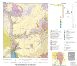
The purpose of this mapping was to determine the bedrock geology that would control or impact ground-water flow from the Espanola basin into the Santo Domingo basin. As it is a multi-purpose geologic map, it is suitable as the geologic layer for any variety of interdisciplinary investigations incorporating geology as a theme.
Are there legal restrictions on access or use of the data?Access_Constraints: None
Use_Constraints:None. However, acknowledgment of the U.S. Geological Survey as source of the data would be appreciated in products derived from these data. These data are not intended to be used at scales larager than 1:24,000.
Although these digital spatial data have been subjected to rigorous review and are substantially complete, it is released on the condition that neither the USGS nor the United States Government may be held liable for any damages resulting from their authorized or unauthorized use.
| Data format: | ARCE, Shapefile (version 8.1) |
|---|---|
| Network links: |
http://pubs.usgs.gov/mf/2002/mf-2352/mf-2352.tar.gz http://pubs.usgs.gov/mf/2002/mf-2352/mf-2352.zip |