All coverages contain the standardized attributes for arcs and polygons assigned by ARC/INFO. For arcs these attributes are:
COLUMN--ITEM_NAME----------WIDTH-----OUTPUT-----TYPE---#_DECIMALS
1-------FNODE#---------------4----------5---------B---------\
5-------TNODE#---------------4----------5---------B---------\
9-------LPOLY#---------------4----------5---------B---------\
13------RPOLY#---------------4----------5---------B---------\
17------LENGTH---------------8---------18---------F---------5
25------<cover>#-------------4----------5---------B---------\
29------<cover>-ID-----------4----------5---------B---------\
For polygons these attributes are:
COLUMN--ITEM_NAME----------WIDTH-----OUTPUT-----TYPE---#_DECIMALS
1-------AREA-----------------8---------18---------F---------5
9-------PERIMETER------------8---------18---------F---------5
17------<cover>#-------------4----------5---------B---------\
21------<cover>-ID-----------4----------5---------B---------\
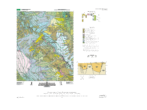
The database consists of seven coverages (and one related scan; see Supplemental_Information) which contain the folowing data:
COVERAGE------------ENTITIES-----------DESCRIPTION
MOUNDSPG-GEO--------POLY/ARC-----------Geologic contacts and unit labels.
MOUNDSPG-FLT--------ARC----------------Geologic structures including faults, fold axes, and tension cracks.
MOUNDSPG-ATT--------POINT--------------Bedding attitudes.
MOUNDSPG-SYM--------ARC----------------Graphical representation of fault offset symbols (strike-slip arrows and bar-and-balls).
MOUNDSPG-GRV--------ARC----------------Graphical representation of gravity contours (includes contour values).
MOUNDSPG-DAT--------POINT/ARC----------U-series and thermoluminescence sample locations and graphical representation of symbols.
MOUNDSPG-TXT--------POINT/ARC----------Unit label points and leader lines.
The individual attributes for each coverage are described as follows:
MOUNDSPG-GEO (polygon attributes):
UNIT--Character attribute for rock unit from text (see table below);
SYMBOL--Integer attribute for polygon shade symbol from shadeset color524.shd (see table below).
MOUNDSPG-GEO (arc attributes):
CODE--Integer attribute for line type (see table below);
DESCRIPTION--Character attribute for line type description (see table below).
MOUNDSPG-FLT (arc attributes):
CODE--Integer attribute for line type (see table below);
DESCRIPTION--Character attribute for line type description (see table below).
MOUNDSPG-ATT (point attributes):
CODE--Integer attribute for line type (see table below);
DESCRIPTION--Character attribute for line type description (see table below);
AZIMUTH--Integer attribute for bedding attitude strike azimuth (clockwise from north);
DIP--Integer attribute for bedding attitude dip value.
MOUNDSPG-SYM (arc attributes):
CODE--Integer attribute for line type (see table below);
DESCRIPTION--Character attribute for line type description (see table below).
MOUNDSPG-GRV (arc attributes):
Only standard ARC attributes.
MOUNDSPG-DAT (arc attributes):
Only standard ARC attributes.
MOUNDSPG-DAT (point attributes):
SAMPLE-ID--Character attribute for U-series and thermoluminescence sample name.
MOUNDSPG-TXT (arc attributes):
Only standard ARC attributes.
MOUNDSPG-TXT (point attributes):
UNIT--Character attribute for rock unit from text (see table below).
UNIT/SYMBOL attribute values (see map text for explanation of lithologic units):
QTa,109
Qai,85
Qau,108
Qay,39
Qayo,40
Qayy,2
Qbo,224
Qbw,222
Qby,216
Qd,19
Qfo,102
Qfy,100
Qpy,6
Qscd,225
Qse,224
Qsu,233
Qsy,221
CODE/DESCRIPTION attribute values:
4 ,"definite contact in quaternary"
5 ,"inferred contact in quaternary"
10 ,"definite high angle fault"
11 ,"inferred high angle fault"
12 ,"concealed high angle fault"
20 ,"definite fold axis"
21 ,"inferred fold axis"
22 ,"concealed fold axis"
88 ,"tension crack"
99 ,"map boundary"
201 ,"bedding strike and dip"
207 ,"bar and ball"
210 ,"right-lateral strike-slip"