Online Links:
QTa,109
Qai,85
Qau,108
Qay,39
Qayo,40
Qayy,2
Qbo,224
Qbw,222
Qby,216
Qd,19
Qfo,102
Qfy,100
Qpy,6
Qscd,225
Qse,224
Qsu,233
Qsy,221
CODE/DESCRIPTION attribute values:
4 ,"definite contact in quaternary"
5 ,"inferred contact in quaternary"
10 ,"definite high angle fault"
11 ,"inferred high angle fault"
12 ,"concealed high angle fault"
20 ,"definite fold axis"
21 ,"inferred fold axis"
22 ,"concealed fold axis"
88 ,"tension crack"
99 ,"map boundary"
201 ,"bedding strike and dip"
207 ,"bar and ball"
210 ,"right-lateral strike-slip"
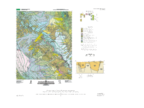
This map was produced in conjunction with the Las Vegas 1:100,000-scale geologic map to fill in previously unmapped areas of surficial geology in the Pahrump Valley area. Mapping in the Pahrump Valley at 1:24,000 scale has been completed jointly by the USGS (Mound Spring quadrangle and Hidden Hills Ranch quadrangle) and the Nevada Bureau of Mines and Geology (Pahrump quadrangle). Mapping was prepared in cooperation with the Nye County Nuclear Waste Repository Project Office. Gravity data was collected to help define the basement structure of the basin and surficial mapping was completed to define the areal extent of deposits, surface expressions of basement structure, areas of past groundwater discharge, areas of surface rupture due to expanding soils and groundwater withdrawl, and significant flash- flood hazards. Dating of soil samples was completed to refine the Cenozoic stratigraphy and correlate surficial units between Pahrump Valley and other nearby basins.
Are there legal restrictions on access or use of the data?Access_Constraints: None
Use_Constraints: None
This database has been approved for release and publication by the Director of the USGS. Although this database has been subjected to rigorous review and is substantially complete, the USGS reserves the right to revise the data pursuant to further analysis and review. Furthermore, it is released on condition that neither the USGS nor the United States Government may be held liable for any damages resulting from its authorized or unauthorized use.
| Data format: | Geologic units and structural features in format ARCE (version 7.1.2) Size: 1.4 |
|---|---|
| Network links: |
http://pubs.usgs.gov/mf/2002/mf-2339/mf-2339.tar.gz http://pubs.usgs.gov/mf/2002/mf-2339/mf-2339.zip |
| Data format: | Geologic units and structural features in format Shapefile (version 1.0) Size: 1.4 |
|---|---|
| Network links: |
http://pubs.usgs.gov/mf/2002/mf-2339/mf-2339.tar.gz http://pubs.usgs.gov/mf/2002/mf-2339/mf-2339.zip |