Quaternary Geologic Map of the Chicago 4° x 6° Quadrangle, United States

Metadata also available as - [Questions & Answers] - [Parseable text] - [XML]

Metadata:

Identification_Information:
Citation:
Citation_Information:
Originator: Gerald M. Richmond (ed.)
Originator: David S. Fullerton (ed.)
Originator: Jerry A. Lineback (comp.)
Originator: Ned K. Bleuer (comp.)
Originator: David M. Mickelson (comp.)
Originator: William R. Farrand (comp.)
Originator: Richard P. Goldthwait (comp.)
Publication_Date: 2001
Title:
Quaternary Geologic Map of the Chicago 4° x 6° Quadrangle, United States
Edition: 1.1
Geospatial_Data_Presentation_Form: (map)
Series_Information:
Series_Name: U.S. Geological Survey Miscellaneous Investigations Series Map
Issue_Identification: I-1420 (NK-16)
Publication_Information:
Publication_Place: Denver, Colorado
Publisher: US Geological Survey
Online_Linkage: http://pubs.usgs.gov/imap/i-1420/nk-16/
Larger_Work_Citation:
Citation_Information:
Originator: U.S. Geological Survey
Publication_Date: 1983
Title: Quaternary geologic atlas of the United States
Geospatial_Data_Presentation_Form: (map)
Series_Information:
Series_Name: U.S. Geological Survey Miscellaneous Investigations Series Map
Issue_Identification: I-1420
Publication_Information:
Publication_Place: Denver, Colorado
Publisher: US Geological Survey

Description:
Abstract:
The Quaternary Geologic Map of the Chicago 4° x 6° Quadrangle was mapped as part of the Quaternary Geologic Atlas of the United States. The atlas was begun as an effort to depict the areal distribution of surficial geologic deposits and other materials that accumulated or formed during the past 2+ million years, the period that includes all activities of the human species. These materials are at the surface of the earth. They make up the "ground" on which we walk, the "dirt" in which we dig foundations, and the "soil" in which we grow crops. Most of our human activity is related in one way or another to these surface materials that are referred to collectively by many geologists as regolith, the mantle of fragmental and generally unconsolidated material that overlies the bedrock foundation of the continent. The maps were compiled at 1:1,000,000 scale.
Purpose:
In recent years, surficial deposits and materials have become the focus of much interest by scientists, environmentalists, governmental agencies, and the general public. They are the foundations of ecosystems, the materials that support plant growth and animal habitat, and the materials through which travels much of the water required for our agriculture, our industry, and our general well being. They also are materials that easily can become contaminated by pesticides, fertilizers, and toxic wastes. In this context, the value of the surficial geologic map is evident
Supplemental_Information:
The digital file was prepared at 1:1,000,000 nominal viewing scale. If the map is enlarged to larger scales (for example, 1:250,000, 1:100,000, or 1:24,000 scale), resolution of the map data is greatly diminished. Enlargement will not restore resolution that was lost by simplification or generalization of data.
This database represents an attempt to digitally capture all the geologic information available on the published paper map. Separate coverages are provided for the map unit polygons, linear glacial features, point data for drumlins and type localities, important stratigraphic sections, and line coverages for the hydrology and topography.
The description of map units and sources of information are both included as PDF files.
The published maps of the Quaternary Geologic Atlas of the U.S. used three separate projections. To promote uniformity, the projection of this database was changed from Lambert Conformal Conic to Albers Equal Area and all subsequent digital databases will similarly be changed to Albers Equal Area Projection.
Illustrations are provided showing relationships of the loess distribution and thickness; late Wisconsin glacial lobes, sublobes and advances within lobes and sublobes, and areas of responsibility for the compilation of the map. An illustration is provided showing the correlation of map units.
Any use of trade, product, or firm names is for descriptive purposes only and does not imply endorsement by the U.S. Government.
Although this Federal Geographic Data Committee- compliant metadata file is intended to document the data set in nonproprietary form, as well as in ARC/INFO format, this metadata file includes some ARC/INFO-specific terminology.
The dataset for the Chicago quadrangle consists of 10 coverages.
       geo_net
       gla_lin
       gla_pnt
       hydr_lin
       topo_lin
       bnd_lin
       bnd_net
       rd_lin
       rr_lin
       grid_lin

The dataset also includes an ARC/INFO AML, lineset, shadeset, and markerset that will produce the EPS file of the geology and glacial features and the list of map units.
Time_Period_of_Content:
Time_Period_Information:
Range_of_Dates/Times:
Beginning_Date: 1978
Ending_Date: 1980
Currentness_Reference: Publication date
Status:
Progress: Complete
Maintenance_and_Update_Frequency: None Planned

Spatial_Domain:
Bounding_Coordinates:
West_Bounding_Coordinate: -90.00
East_Bounding_Coordinate: -84.00
North_Bounding_Coordinate: 44.00
South_Bounding_Coordinate: 40.00

Keywords:
Theme:
Theme_Keyword_Thesaurus: USGS Thesaurus
Theme_Keyword: geology
Theme_Keyword: geologic maps
Theme_Keyword: surficial geologic units
Theme_Keyword: geospatial datasets
Theme_Keyword: unconsolidated deposits
Theme_Keyword: Quaternary
Theme:
Theme_Keyword_Thesaurus:
American Geological Institute (AGI) Glossary of Geology
Theme_Keyword: Alluvium
Theme_Keyword: Beach deposits
Theme_Keyword: Coastal deposits
Theme_Keyword: Colluvium
Theme_Keyword: Decomposition residuum
Theme_Keyword: Delta
Theme_Keyword: Drumlin
Theme_Keyword: Dune
Theme_Keyword: Eolian deposits
Theme_Keyword: Esker
Theme_Keyword: Genesis
Theme_Keyword: Geologic history
Theme_Keyword: Geologic map
Theme_Keyword: Geology
Theme_Keyword: Glacial deposits
Theme_Keyword: Glacial limits
Theme_Keyword: Glaciofluvial deposits
Theme_Keyword: Glaciotectonic deposits
Theme_Keyword: Holocene
Theme_Keyword: Ice-contact deposits
Theme_Keyword: Ice-molded landforms
Theme_Keyword: Lacustrine deposits
Theme_Keyword: Marine deposits
Theme_Keyword: Marsh deposits
Theme_Keyword: Moraine
Theme_Keyword: Outwash deposits
Theme_Keyword: Quaternary
Theme_Keyword: Quaternary geology
Theme_Keyword: Regional geology
Theme_Keyword: Residuum
Theme_Keyword: Sand deposits
Theme_Keyword: Saprolite
Theme_Keyword: Sedimentary Rocks
Theme_Keyword: Solifluction deposits
Theme_Keyword: Surficial deposits
Theme_Keyword: Surficial geology
Theme_Keyword: Swamp deposits
Theme_Keyword: Till
Theme:
Theme_Keyword_Thesaurus: ISO 19115 Topic Categories
Theme_Keyword: geoscientificInformation
Place:
Place_Keyword_Thesaurus: U.S. Board on Geographic Names (BGN)
Place_Keyword: Canada
Place_Keyword: Great Lakes
Place_Keyword: Illinois
Place_Keyword: Indiana
Place_Keyword: Lake Michigan
Place_Keyword: Michigan
Place_Keyword: Ohio
Place_Keyword: United States
Place_Keyword: Wisconsin
Place:
Place_Keyword_Thesaurus: Augmented FIPS 10-4 and FIPS 6-4
Place_Keyword: f17007 = Boone
Place_Keyword: f17011 = Bureau
Place_Keyword: f17015 = Carroll
Place_Keyword: f17017 = Cass
Place_Keyword: f17019 = Champaign
Place_Keyword: f17031 = Cook
Place_Keyword: f17037 = DeKalb
Place_Keyword: f17039 = De Witt
Place_Keyword: f17043 = DuPage
Place_Keyword: f17053 = Ford
Place_Keyword: f17057 = Fulton
Place_Keyword: f17063 = Grundy
Place_Keyword: f17073 = Henry
Place_Keyword: f17075 = Iroquois
Place_Keyword: f17085 = Jo Daviess
Place_Keyword: f17089 = Kane
Place_Keyword: f17091 = Kankakee
Place_Keyword: f17093 = Kendall
Place_Keyword: f17095 = Knox
Place_Keyword: f17097 = Lake
Place_Keyword: f17099 = La Salle
Place_Keyword: f17103 = Lee
Place_Keyword: f17105 = Livingston
Place_Keyword: f17107 = Logan
Place_Keyword: f17111 = McHenry
Place_Keyword: f17113 = McLean
Place_Keyword: f17115 = Macon
Place_Keyword: f17123 = Marshall
Place_Keyword: f17125 = Mason
Place_Keyword: f17129 = Menard
Place_Keyword: f17141 = Ogle
Place_Keyword: f17143 = Peoria
Place_Keyword: f17147 = Piatt
Place_Keyword: f17155 = Putnam
Place_Keyword: f17175 = Stark
Place_Keyword: f17177 = Stephenson
Place_Keyword: f17179 = Tazewell
Place_Keyword: f17183 = Vermilion
Place_Keyword: f17195 = Whiteside
Place_Keyword: f17197 = Will
Place_Keyword: f17201 = Winnebago
Place_Keyword: f17203 = Woodford
Place_Keyword: f18001 = Adams
Place_Keyword: f18003 = Allen
Place_Keyword: f18007 = Benton
Place_Keyword: f18009 = Blackford
Place_Keyword: f18011 = Boone
Place_Keyword: f18015 = Carroll
Place_Keyword: f18017 = Cass
Place_Keyword: f18023 = Clinton
Place_Keyword: f18033 = De Kalb
Place_Keyword: f18035 = Delaware
Place_Keyword: f18039 = Elkhart
Place_Keyword: f18045 = Fountain
Place_Keyword: f18049 = Fulton
Place_Keyword: f18053 = Grant
Place_Keyword: f18057 = Hamilton
Place_Keyword: f18065 = Henry
Place_Keyword: f18067 = Howard
Place_Keyword: f18069 = Huntington
Place_Keyword: f18073 = Jasper
Place_Keyword: f18075 = Jay
Place_Keyword: f18085 = Kosciusko
Place_Keyword: f18087 = Lagrange
Place_Keyword: f18089 = Lake
Place_Keyword: f18091 = La Porte
Place_Keyword: f18095 = Madison
Place_Keyword: f18099 = Marshall
Place_Keyword: f18103 = Miami
Place_Keyword: f18107 = Montgomery
Place_Keyword: f18111 = Newton
Place_Keyword: f18113 = Noble
Place_Keyword: f18127 = Porter
Place_Keyword: f18131 = Pulaski
Place_Keyword: f18135 = Randolph
Place_Keyword: f18141 = St. Joseph
Place_Keyword: f18149 = Starke
Place_Keyword: f18151 = Steuben
Place_Keyword: f18157 = Tippecanoe
Place_Keyword: f18159 = Tipton
Place_Keyword: f18165 = Vermillion
Place_Keyword: f18169 = Wabash
Place_Keyword: f18171 = Warren
Place_Keyword: f18177 = Wayne
Place_Keyword: f18179 = Wells
Place_Keyword: f18181 = White
Place_Keyword: f18183 = Whitley
Place_Keyword: f26005 = Allegan
Place_Keyword: f26011 = Arenac
Place_Keyword: f26015 = Barry
Place_Keyword: f26017 = Bay
Place_Keyword: f26021 = Berrien
Place_Keyword: f26023 = Branch
Place_Keyword: f26025 = Calhoun
Place_Keyword: f26027 = Cass
Place_Keyword: f26035 = Clare
Place_Keyword: f26037 = Clinton
Place_Keyword: f26045 = Eaton
Place_Keyword: f26051 = Gladwin
Place_Keyword: f26057 = Gratiot
Place_Keyword: f26059 = Hillsdale
Place_Keyword: f26065 = Ingham
Place_Keyword: f26067 = Ionia
Place_Keyword: f26073 = Isabella
Place_Keyword: f26075 = Jackson
Place_Keyword: f26077 = Kalamazoo
Place_Keyword: f26081 = Kent
Place_Keyword: f26085 = Lake
Place_Keyword: f26091 = Lenawee
Place_Keyword: f26093 = Livingston
Place_Keyword: f26105 = Mason
Place_Keyword: f26107 = Mecosta
Place_Keyword: f26111 = Midland
Place_Keyword: f26117 = Montcalm
Place_Keyword: f26121 = Muskegon
Place_Keyword: f26123 = Newaygo
Place_Keyword: f26127 = Oceana
Place_Keyword: f26133 = Osceola
Place_Keyword: f26139 = Ottawa
Place_Keyword: f26145 = Saginaw
Place_Keyword: f26149 = St. Joseph
Place_Keyword: f26155 = Shiawassee
Place_Keyword: f26159 = Van Buren
Place_Keyword: f26161 = Washtenaw
Place_Keyword: f39003 = Allen
Place_Keyword: f39011 = Auglaize
Place_Keyword: f39021 = Champaign
Place_Keyword: f39023 = Clark
Place_Keyword: f39037 = Darke
Place_Keyword: f39039 = Defiance
Place_Keyword: f39051 = Fulton
Place_Keyword: f39069 = Henry
Place_Keyword: f39091 = Logan
Place_Keyword: f39107 = Mercer
Place_Keyword: f39109 = Miami
Place_Keyword: f39125 = Paulding
Place_Keyword: f39137 = Putnam
Place_Keyword: f39149 = Shelby
Place_Keyword: f39161 = Van Wert
Place_Keyword: f39171 = Williams
Place_Keyword: f55001 = Adams
Place_Keyword: f55015 = Calumet
Place_Keyword: f55021 = Columbia
Place_Keyword: f55025 = Dane
Place_Keyword: f55027 = Dodge
Place_Keyword: f55039 = Fond du Lac
Place_Keyword: f55047 = Green Lake
Place_Keyword: f55049 = Iowa
Place_Keyword: f55055 = Jefferson
Place_Keyword: f55057 = Juneau
Place_Keyword: f55059 = Kenosha
Place_Keyword: f55065 = Lafayette
Place_Keyword: f55071 = Manitowoc
Place_Keyword: f55077 = Marquette
Place_Keyword: f55079 = Milwaukee
Place_Keyword: f55089 = Ozaukee
Place_Keyword: f55101 = Racine
Place_Keyword: f55105 = Rock
Place_Keyword: f55111 = Sauk
Place_Keyword: f55117 = Sheboygan
Place_Keyword: f55127 = Walworth
Place_Keyword: f55131 = Washington
Place_Keyword: f55133 = Waukesha
Place_Keyword: f55137 = Waushara
Place_Keyword: f55139 = Winnebago

Temporal:
Temporal_Keyword_Thesaurus:
Richmond, G.M., and Fullerton, D.S., eds., 1986, Introduction, in Quaternary glaciations in the United States of America: Quaternary Science Reviews, v. 5.
Temporal_Keyword: Early Wisconsin
Temporal_Keyword: Holocene
Temporal_Keyword: Illinoian
Temporal_Keyword: Late Wisconsin
Temporal_Keyword: Pleistocene
Temporal_Keyword: Pre Wisconsin
Temporal_Keyword: Quaternary
Temporal_Keyword: Tertiary
Temporal_Keyword: Wisconsin

Access_Constraints: None

Use_Constraints:
Acknowledgment of the Quaternary Geologic Atlas of the United States of America and (or) the U.S. Geological Survey in products derived from these data will be appreciated.
Point_of_Contact:
Contact_Information:
Contact_Person_Primary:
Contact_Person: Charles A. Bush
Contact_Organization: U.S. Geological Survey
Contact_Position: Emeritus Geophysicist
Contact_Address:
Address_Type: Mailing and physical address
Address: Mail Stop 913, Box 25046, Federal Center
City: Lakewood
State_or_Province: Colorado
Postal_Code: 80225
Country: USA
Contact_Voice_Telephone: (303) 236-4723
Contact_Facsimile_Telephone: (303) 236-0214
Contact_Electronic_Mail_Address: cbush@usgs.gov

Browse_Graphic:
Browse_Graphic_File_Name: http://pubs.usgs.gov/imap/i-1420/nk-16/chicago.gif
Browse_Graphic_File_Description:
Reduced-size image of the entire map sheet, 500x264 pixels, 72k bytes.
Browse_Graphic_File_Type: GIF

Browse_Graphic:
Browse_Graphic_File_Name: Browse_Graphic_File_Description:
Scan of the original published paper map optimized for viewing on screen, 9.8 MB.
Browse_Graphic_File_Type: PDF

Data_Set_Credit:
The Quaternary Geologic Map of the Chicago 4 Degree x 6 Degree Quadrangle, United States, I-1420 (NK-16) was compiled by Jerry A. Lineback, Illinois State Geological Survey, Ned K. Bleuer, Indiana Geological Survey, David M. Mickelson, Department of Geology and Geophysics, University of Wisconsin, William R. Farrand, Department of Geological Sciences, University of Michigan, and Richard P. Goldthwait, Department of Geology and Mineralogy, Ohio State University. The state compilations were edited and integrated by Gerald M. Richmond and David S. Fullerton, U.S. Geological Survey. The compilations of geology and glacial features were converted to digital form by Techni Graphic Systems, Inc., of Fort Collins, CO, under contract with the U.S. Geological Survey and modified by Charles A. Bush. The hydrography layer was prepared by Sharon Smith, U.S. Geological Survey. Illustrations, wordprocessor files, the topographic layer, and DLG coverages were prepared by Bush.
Native_Data_Set_Environment:
Windows_NT, 4.0, Intel ARC/INFO version 7.2.1
Data_Quality_Information:
Attribute_Accuracy:
Attribute_Accuracy_Report:
Compilation of geologic data: The accuracy of the map data is dependent on (1) the accuracy of the original source data, (2) the accuracy of transfer of that data to larger scale bases by the compilers, (3) the procedures by which the compilers and the editor/integrator simplified or generalized the data, and (4) the procedures used by, and the objectivity exercised by, the editor/integrator in integration of adjacent parts of the map that were prepared by different compilers. Consequently, aspects of accuracy for the data set cannot be quantified.
Digitization and attributing of compilation: Digitizing contractor scanned source stable-base material, vectorized scan, attributed files, and produced check plots and coverages. C.A. Bush proofread check plots and reviewed digital files; made final corrections as needed; produced graphical files and imported them into graphics program to prepare plot file; proofread cartographic product; prepared illustrations and word processing files of descriptions of map units and sources of information. The original paper map was scanned and recreated as PDF files. (The original map was thoroughly reviewed for conformity with U.S. Geological Survey editorial standards and stratigraphic nomenclature.)
Logical_Consistency_Report:
Polygon and chain-node topology are present. The ARC/INFO commands BUILD and CLEAN were run to ensure the topological consistency of the data set. All polygons are labeled and were tested by using the ARC/INFO command LABELERRORS. All polygons were checked for closure and intersections.
Completeness_Report:
These coverages contain polygons for all the map units, lines for all the contacts and glacial features, and points for all the locations of localities and drumlins. All geologic data from the original map are expressed on this map. Any differences between elements on the original map and attributed polygons, arcs, and points in this database are inadvertent and should not be construed as deliberate alterations of the data.
Positional_Accuracy:
Horizontal_Positional_Accuracy:
Horizontal_Positional_Accuracy_Report:
The accuracy of location of polygons, lines, and points is consistent with the map scale of 1:1,000,000.
Lineage:
Source_Information:
Source_Citation:
Citation_Information:
Originator: Gerald M. Richmond (ed.)
Originator: David S. Fullerton (ed.)
Originator: Jerry A. Lineback (comp.)
Originator: Ned K. Bleuer, (comp.)
Originator: David M. Mickelson (comp.)
Originator: William R. Farrand (comp.
Originator: Richard P. Goldthwait (comp.)
Publication_Date: 1983
Title:
Quaternary Geologic Map of the Chicago 4° x 6° Quadrangle, United States
Geospatial_Data_Presentation_Form: map
Series_Information:
Series_Name: Miscellaneous Investigations Series
Issue_Identification: I-1420 (NK-16)
Publication_Information:
Publication_Place: Reston, Virginia
Publisher: U.S. Geological Survey
Source_Scale_Denominator: 1000000
Type_of_Source_Media:
mylar separates from printer's negatives for printed map
Source_Time_Period_of_Content:
Time_Period_Information:
Range_of_Dates/Times:
Beginning_Date: 1978
Ending_Date: 1980
Source_Currentness_Reference: Publication date
Source_Citation_Abbreviation: Richmond and Fullerton, 1983
Source_Contribution: Linework and point data for the data sets
Source_Information:
Source_Citation:
Citation_Information:
Originator: U.S. Geological Survey
Publication_Date: 1995
Title:
1:2,000,000-scale Digital Line Graphs -Railroad, Roads, and Boundaries features
Geospatial_Data_Presentation_Form: map
Publication_Information:
Publication_Place: Reston, Virginia
Publisher: U.S. Geological Survey
Source_Scale_Denominator: 2000000
Type_of_Source_Media: online
Source_Time_Period_of_Content:
Time_Period_Information:
Range_of_Dates/Times:
Beginning_Date: 1972
Ending_Date: 1994
Source_Currentness_Reference: Publication date
Source_Citation_Abbreviation: 2MILDLG
Source_Contribution: spatial and attribute information

Process_Step:
Process_Description:
Digitizing contractor scanned source stable-base material for geology and glacial layers, vectorized scan, converted into ARC/INFO coverages and attributed files from published paper map, and produced check plots and coverages.
Process_Date: 1999

Process_Step:
Process_Description:
Sharon Smith, U.S. Geological Survey, scanned source stable-base material for hydrology layer, vectorized scan, and converted into ARC/INFO coverage.
Process_Date: 2000

Process_Step:
Process_Description:
Wallace K. Fisk, U.S. Geological Survey, scanned source stable- base material for topography layer, vectorized scan, and converted into ARC/INFO coverage.
Process_Date: 2000

Process_Step:
Process_Description:
C.A. Bush acquired U.S. Geological Survey DLG 1:2,000,000 digital data for roads, railroads, and county boundaries. Data was obtained for individual states, combined, and clipped to cover only the area of the map. Since the files are intended only for the user's reference, and to reduce file size, all attributes were removed from the railroad coverage. All attributes were removed from the roads coverage except U.S. and State highway designations. All attributes were removed from the boundaries coverage except those containing state or county names. A coverage was created containing map boundaries and state and international boundaries. These coverages do not exactly match the base used in preparation of the original Quaternary Atlas map, but are included for the user's convenience.
Process_Date: 2001

Process_Step:
Process_Description:
C.A. Bush created illustration of the index map on the paper map in a drawing program and changed it to reflect the status of conversion of Quaternary Geologic Atlas quadrangles to digital databases. Bush scanned loess distribution, glacial lobe chronology, state and province compilation responsibility and map unit correlation diagrams as given on the printed map and converted them to PDF format.
Process_Date: 2001

Process_Step:
Process_Description:
Map unit descriptions and sources of information as given on the printed map were scanned and converted by an Optical Character Recognition computer program into text files and to PDF format(Bush).
Process_Date: 2001

Process_Step:
Process_Description:
Coverages of geology and glacial features were checked and corrected or changed. Additional items were included in the attributes. AML's were created to plot the data. Plots were imported into graphics program to create a plot of the map (Bush).
Process_Date: 2001

Process_Step:
Process_Description: Original map was scanned and recreated as PDF file.
Process_Date: 2001

Process_Step:
Process_Description:
Illustrations and text files were checked and edited by Bush.
Process_Date: 2001

Process_Step:
Process_Description: Creation of original metadata record
Process_Date: 20020501
Process_Contact:
Contact_Information:
Contact_Person_Primary:
Contact_Person: Charles A. Bush
Contact_Organization: U.S. Geological Survey
Contact_Position: Emeritus Geophysicist
Contact_Address:
Address_Type: Mailing
Address:
U.S. Geological Survey, MS913, Box 25046, Denver Federal
Center
City: Denver
State_or_Province: CO
Postal_Code: 80225
Country: USA
Contact_Voice_Telephone: (303) 236-4723
Contact_Facsimile_Telephone: (303) 236-0214
Contact_Electronic_Mail_Address: cbush@usgs.gov
Spatial_Data_Organization_Information:
Direct_Spatial_Reference_Method: Vector
Point_and_Vector_Object_Information:
SDTS_Terms_Description:
SDTS_Point_and_Vector_Object_Type: Point
Point_and_Vector_Object_Count: 3119
SDTS_Terms_Description:
SDTS_Point_and_Vector_Object_Type: String
Point_and_Vector_Object_Count: 7712
SDTS_Terms_Description:
SDTS_Point_and_Vector_Object_Type: GT-polygon composed of chains
Point_and_Vector_Object_Count: 3120

Spatial_Reference_Information:
Horizontal_Coordinate_System_Definition:
Planar:
Map_Projection:
Map_Projection_Name: Albers Conical Equal Area
Albers_Conical_Equal_Area:
Standard_Parallel: 29.5
Standard_Parallel: 45.5
Longitude_of_Central_Meridian: -96
Latitude_of_Projection_Origin: 23
False_Easting: 0.0
False_Northing: 0.0
Planar_Coordinate_Information:
Planar_Coordinate_Encoding_Method: coordinate pair
Coordinate_Representation:
Abscissa_Resolution: 55
Ordinate_Resolution: 55
Planar_Distance_Units: Meters
Geodetic_Model:
Horizontal_Datum_Name: North American Datum of 1983
Ellipsoid_Name: GRS1980
Semi-major_Axis: 6378206.4
Denominator_of_Flattening_Ratio: 294.98

Entity_and_Attribute_Information:
Overview_Description:
Entity_and_Attribute_Overview:
The geo_net coverage includes polygons that are map units and open water, and arcs that are contacts, colorboundaries, and shoreline.
The geo_net.pat INFO file consists of the following items:
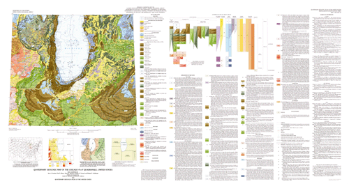
GEOCODE--Refers to the type of polygon and is one of the following: map unit code, "lake", or "island".
AGE--Refers to the age of the map unit and is one of the following: "HOLOCENE", "HOLOCENE AND LATE WISCONSIN", "LATE WISCONSIN", "EARLY WISCONSIN", "WISCONSIN", "ILLINOIAN", "PLEISTOCENE", "QUATERNARY" OR "PRE-QUATERNARY".
MORAINES--A modifier to the map unit indicating that the unit is a moraine and is one of the following: "Ground Moraine", "End Moraine", or "Ground Moraine and end moraine under Lake Michigan."
MAP_UNITS--A description of the soils within the map units (see below).
MODIFIER--Indicates that the map unit is covered with loess more than 2 m thick ("loess mantle") or if the unit is under water ("submerged").
COLOR--An integer value representing a shade pattern in the shadeset color524.shd used in preparing the plotfile of the map.
Items in geo_net.pat are defined as follows:
GEOCODE	MAPUNITS, (AGE)

lc	LAKE CLAY AND SILT UNDER LAKE MICHIGAN, HOLOCENE
ls	LAKE SAND AND GRAVEL UNDER LAKE MICHIGAN, HOLOCENE

al	ALLUVIUM, HOLOCENE AND LATE WISCONSIN
hs	SWAMP DEPOSIT, HOLOCENE AND LATE WISCONSIN
hp	PEAT, HOLOCENE AND LATE WISCONSIN
es	EOLIAN SHEET SAND, HOLOCENE AND LATE WISCONSIN
ed	DUNE SAND, HOLOCENE AND LATE WISCONSIN
el	LOESS, HOLOCENE AND LATE WISCONSIN
ca	COLLUVIUM AND SHEETWASH ALLUVIUM, HOLOCENE AND LATE WISCONSIN

lca	LAKE CLAY AND SILT, LATE WISCONSIN
lsa	LAKE SAND AND GRAVEL, LATE WISCONSIN
gg	OUTWASH SAND AND GRAVEL, LATE WISCONSIN
gs	OUTWASH SAND, LATE WISCONSIN
kg	ICE-CONTACT SAND AND GRAVEL, LATE WISCONSIN

		Tills in Wisconsin, Michigan, Indiana, and Ohio
tc	CLAYEY TILL--Ground moraine, LATE WISCONSIN
tc	CLAYEY TILL--End moraine, LATE WISCONSIN
tca	CLAYEY TILL--Ground moraine, LATE WISCONSIN
tca	CLAYEY TILL--End moraine, LATE WISCONSIn
tcb	CLAYEY TILL--Ground moraine, LATE WISCONSIN
tcb	CLAYEY TILL--End moraine, LATE WISCONSIN
tl	LOAMY TILL--Ground moraine, LATE WISCONSIN
tl	LOAMY TILL--End moraine, LATE WISCONSIN
tlg	LOAMY TILL--Ground moraine, LATE WISCONSIN
tlg	LOAMY TILL--End moraine, LATE WISCONSIN
td	SANDY LOAMY TILL--Ground moraine, LATE WISCONSIN
td	SANDY LOAMY TILL--End moraine, LATE WISCONSIN

		Till Members of Wedron Formation in Illinois and under
 		Lake Michigan, and Equivalent Tills in Adjacent Wisconsin
		and Indiana
tac	CLAYEY TILL (MANITOWOC TILL MEMBER UNDER LAKE MICHIGAN),
	  LATE WISCONSIN
tad	CLAYEY TILL (SHOREWOOD TILL MEMBER UNDER LAKE MICHIGAN),
	  LATE WISCONSIN
tah	CLAYEY TILL (WADSWORTH TILL MEMBER IN ILLINOIS AND ITS EQUIVALENT
	  IN INDIANA)--Ground moraine, LATE WISCONSIN
tah	CLAYEY TILL (WADSWORTH TILL MEMBER IN ILLINOIS AND ITS EQUIVALENT
	  IN INDIANA)--Ground moraine and end moraine under Lake Michigan,
	  LATE WISCONSIN
tah	CLAYEY TILL (WADSWORTH TILL MEMBER IN ILLINOIS AND ITS EQUIVALENT
	  IN INDIANA)--End moraine, LATE WISCONSIN
tea	SANDY LOAMY TILL (HAEGER TILL MEMBER IN ILLINOIS AND ITS EQUIVALENT
	  IN WISCONSIN)--Ground moraine, LATE WISCONSIN
tea	SANDY LOAMY TILL (HAEGER TILL MEMBER IN ILLINOIS AND ITS EQUIVALENT
	  IN WISCONSIN)--End moraine, LATE WISCONSIN
taj	CLAYEY TILL (YORKVILLE TILL MEMBER IN ILLINOIS AND ITS EQUIVALENT
	  IN INDIANA)--Ground moraine, LATE WISCONSIN
taj	CLAYEY TILL (YORKVILLE TILL MEMBER IN ILLINOIS AND ITS EQUIVALENT
	  IN INDIANA)--End moraine, LATE WISCONSIN
tan	CLAYEY TILL (SNIDER TILL MEMBER IN ILLINOIS AND ITS EQUIVALENT IN
	  INDIANA)--Ground moraine, LATE WISCONSIN
tan	CLAYEY TILL (SNIDER TILL MEMBER IN ILLINOIS AND ITS EQUIVALENT IN
	  INDIANA)--End moraine, LATE WISCONSIN
tkb	LOAMY TILL (BATESTOWN TILL MEMBER, MALDEN TILL MEMBER, AND MALDEN
	  AND SNIDER TILL MEMBERS UNDIFFERENTIATED IN ILLINOIS; BATESTOWN
	  TILL MEMBER EQUIVALENT IN INDIANA)--Ground moraine, LATE WISCONSIN
tkb	LOAMY TILL (BATESTOWN TILL MEMBER, MALDEN TILL MEMBER, AND MALDEN
	  AND SNIDER TILL MEMBERS UNDIFFERENTIATED IN ILLINOIS; BATESTOWN
	  TILL MEMBER EQUIVALENT IN INDIANA)--End moraine, LATE WISCONSIN
tkc	LOAMY TILL (PIATT TILL MEMBER)--Ground moraine, LATE WISCONSIN
tkc	LOAMY TILL (PIATT TILL MEMBER)--End moraine, LATE WISCONSIN
tkd	LOAMY TILL (TISKILWA, DELAVAN, AND FAIRGRANGE TILL MEMBERS IN
       ILLINOIS; FAIRGRANGE TILL MEMBER EQUIVALENT IN INDIANA)
       --Ground moraine, LATE WISCONSIN
tkd	LOAMY TILL (TISKILWA, DELAVAN, AND FAIRGRANGE TILL MEMBERS IN
       ILLINOIS; FAIRGRANGE TILL MEMBER EQUIVALENT IN INDIANA)
         --End moraine, LATE WISCONSIN


tkj	LOAMY TILL (CAPRON TILL MEMBER OF WINNEBAGO FORMATION IN ILLINOIS
	  AND EQUIVALENT TILL IN WISCONSIN), EARLY WISCONSIN
tej	SANDY LOAMY TILL (ARGYLE TILL MEMBER OF WINNEBAGO FORMATION IN
	  ILLINOIS AND EQUIVALENT TILL IN WISCONSIN)--Ground moraine,
       EARLY WISCONSIN
tej	SANDY LOAMY TILL (ARGYLE TILL MEMBER OF WINNEBAGO FORMATION IN
       ILLINOIS AND EQUIVALENT TILL IN WISCONSIN)--End moraine,
	  EARLY WISCONSIN
lcd	LAKE SILT AND CLAY, WISCONSIN
lci	LAKE SILT AND CLAY, ILLINOIAN
lsp	LAKE SAND AND SILT, ILLINOIAN
gsi	OUTWASH SILT, SAND, AND GRAVEL, ILLINOIAN
kgi	ICE-CONTACT SAND AND GRAVEL, ILLINOIAN


tal	CLAYEY TILL (RADNOR AND STERLING TILL MEMBERS OF GLASFORD
	  FORMATION IN ILLINOIS), ILLINOIAN
tag	CLAYEY TILL (ESMOND TILL MEMBER OF GLASFORD FORMATION IN ILLINOIS),
	  ILLINOIAN
tke	LOAMY TILL (LEE CENTER TILL MEMBER OF GLASFORD FORMATION IN
	  ILLINOIS) --Ground moraine, ILLINOIAN
tke	LOAMY TILL (LEE CENTER TILL MEMBER OF GLASFORD FORMATION IN
	  ILLINOIS) --End moraine, ILLINOIAN
tkm	LOAMY TILL (OGLE, HULICK, AND VANDALIA TILL MEMBERS OF GLASFORD
	  FORMATION IN ILLINOIS; OGLE TILL MEMBER EQUIVALENT IN WISCONSIN),
	  ILLINOIAN
tam	CLAYEY TILL (WINSLOW TILL MEMBER OF GLASFORD FORMATION IN ILLINOIS
	  AND ITS EQUIVALENT IN WISCONSIN)--Ground moraine, ILLINOIAN
tam	CLAYEY TILL (WINSLOW TILL MEMBER OF GLASFORD FORMATION IN ILLINOIS
	  AND ITS EQUIVALENT IN WISCONSIN)--End moraine, ILLINOIAN
cr	COLLUVIUM, PLEISTOCENE
cc	COLLUVIUM, QUATERNARY
R	BEDROCK, PRE-QUATERNARY
f     MANMADE

NOTE:  All units listed as EARLY WISCONSIN on the original map are
presently recognized as being ILLINOIAN.  Unit lcd listed as WISCONSIN
is probably ILLINOIAN and may be the same map unit as lci.
The geo_net.aat INFO file consists of the following item: LTYPE--Refers to the type of arc and is one of the following: "contact," "shoreline," or "map boundary."
The gla_lin coverage contains lines of linear glacial features. The gla_lin.aat INFO file consists of the following items: TYPE--Refers to the type of glacial feature described by the arc and is one of the following: "esker," "limit of glacial advance," "buried moraine," "meltwater channel," "shoreline deposits," or "map boundary". MODIFIER--Refers only to ltype = "meltwater channel" and is either "left bank" or "right bank". ACCURACY--Refers to accuracy of location of arcs in the gla_lin coverage and is either "certain" or "inferred". NAME--Refers to the geounit name (taj) of inferred buried end moraine.
The gla_pnt coverage contains points that represent drumlins, places where the direction of ice movement is indicated by striations, or the location of important stratigraphic sections. The gla_pnt.pat INFO file consists of the following items: TYPE--Refers to the type of feature shown at the point and is one of the following: "drumlin," "direction of ice movement," "concentric minor moraines," "glacially fluted landforms," "wind direction," or the name of important stratigraphic sections. ANGLE--Refers to the direction of drumlin or ice movement; in degrees measured clockwise from north. MRKANGLE--Negative of ANGLE; useful for plotting srmbols in ARCPLOT.
Hydr_lin is a line coverage created after scanning the hydrographic layer that was used in the original paper map. It has no attributes.
Topo_lin is a line coverage created after scanning the topographic layer that was used in the original paper map. It has no attributes.
Bnd_lin is a line coverage created from 1:2,000,000-scale U.S. Geological Survey Digital Line Graph coverages (DLG). It contains lines representing state boundaries. The bnd_lin.aat INFO file contains the following item: LTYPE--Refers to the type of line and contains the values: "state boundary", or "map boundary". The coverage is annotated with state names along boundaries.
Bnd_net is a polygon coverage created from 1:2,000,000-scale DLG coverages and contains political and administrative boundaries. Polygons are attributed in the standard DLG coding scheme and the Federal Information Processing Standards (FIPS).
Rd_lin is a line coverage created from 1:2,000,000-scale DLG coverages. The coverage contains lines representing roads in the map area. All DLG attributes have been stripped from the lines except ROUTE_NUMBER1, ROUTE_NUMBER2, ROUTE_NUMBER3, and ROUTE_NUMBER4.
Rr_lin is a line coverage created from 1:2,000,000-scale DLG coverages. The coverage contains lines representing railroads in the map area. It has no DLG attributes.
Grid_lin is a line coverage created to display projection lines in one degree increments. It has no attributes.
Entity_and_Attribute_Detail_Citation:
Distribution_Information:
Distributor:
Contact_Information:
Contact_Organization_Primary:
Contact_Organization:
U.S. Geological Survey, Geologic Division, Central Publications Group
Contact_Address:
Address_Type: Mailing address
Address:
U.S. Geological Survey, MS902, Box 25046, Denver Federal
Center
City: Denver
State_or_Province: CO
Postal_Code: 80225
Country: USA
Contact_Voice_Telephone: (303) 236-7684
Contact_Facsimile_Telephone: (303) 236-6287
Contact_Electronic_Mail_Address: troudebush@usgs.gov

Resource_Description:
Miscellaneous Investigations Series Map I-1420 (NK-16), "Quaternary Geologic Map of the Chicago 4° × 6° Quadrangle, United States"
Distribution_Liability:
Any use of trade, product, or firm names is for descriptive purposes only and does not imply endorsement by the U.S. Government. Although this data set has been used by the U.S. Geological Survey, no warranty, expressed or implied, is made by the USGS as to the accuracy and functioning of the data set and related material nor shall the fact of distribution constitute any such warranty, and no responsibility is assumed by the USGS in connection therewith.
Standard_Order_Process:
Digital_Form:
Digital_Transfer_Information:
Format_Name: Shapefile
Format_Version_Number: 1.0
Format_Information_Content: Geologic units, glacial features
File_Decompression_Technique: unzip
Transfer_Size: 8
Digital_Transfer_Option:
Online_Option:
Computer_Contact_Information:
Network_Address:
Digital_Form:
Digital_Transfer_Information:
Format_Name: ARCE
Format_Version_Number: 7.2.1
Format_Information_Content: Geologic units, glacial features
File_Decompression_Technique: unzip
Transfer_Size: 8
Digital_Transfer_Option:
Online_Option:
Computer_Contact_Information:
Network_Address:
Fees: none
Metadata_Reference_Information:
Metadata_Date: 20160613
Metadata_Contact:
Contact_Information:
Contact_Person_Primary:
Contact_Person: Peter N Schweitzer
Contact_Organization: USGS Midwest Area
Contact_Position:
Collection manager, USGS Geoscience Data Clearinghouse, http://geo-nsdi.er.usgs.gov/
Contact_Address:
Address_Type: mailing address
Address:
Mail Stop 954
12201 Sunrise Valley Dr
City: Reston
State_or_Province: VA
Postal_Code: 20192-0002
Country: USA
Contact_Voice_Telephone: 703-648-6533
Contact_Facsimile_Telephone: 703-648-6252
Contact_Electronic_Mail_Address: pschweitzer@usgs.gov
Metadata_Standard_Name: Content Standard for Digital Geospatial Metadata
Metadata_Standard_Version: FGDC-STD-001-1998


This page is <https://geo-nsdi.er.usgs.gov/metadata/map-i/1420/NK-16/metadata.html>
Generated by mp version 2.9.48 on Tue Jul 03 20:04:45 2018