Quaternary Geologic Map of the Chicago 4° x 6° Quadrangle, United States

Metadata also available as - [Outline] - [Parseable text] - [XML]

Frequently anticipated questions:


What does this data set describe?

Title:
Quaternary Geologic Map of the Chicago 4° x 6° Quadrangle, United States
Abstract:
The Quaternary Geologic Map of the Chicago 4° x 6° Quadrangle was mapped as part of the Quaternary Geologic Atlas of the United States. The atlas was begun as an effort to depict the areal distribution of surficial geologic deposits and other materials that accumulated or formed during the past 2+ million years, the period that includes all activities of the human species. These materials are at the surface of the earth. They make up the "ground" on which we walk, the "dirt" in which we dig foundations, and the "soil" in which we grow crops. Most of our human activity is related in one way or another to these surface materials that are referred to collectively by many geologists as regolith, the mantle of fragmental and generally unconsolidated material that overlies the bedrock foundation of the continent. The maps were compiled at 1:1,000,000 scale.
Supplemental_Information:
The digital file was prepared at 1:1,000,000 nominal viewing scale. If the map is enlarged to larger scales (for example, 1:250,000, 1:100,000, or 1:24,000 scale), resolution of the map data is greatly diminished. Enlargement will not restore resolution that was lost by simplification or generalization of data.
This database represents an attempt to digitally capture all the geologic information available on the published paper map. Separate coverages are provided for the map unit polygons, linear glacial features, point data for drumlins and type localities, important stratigraphic sections, and line coverages for the hydrology and topography.
The description of map units and sources of information are both included as PDF files.
The published maps of the Quaternary Geologic Atlas of the U.S. used three separate projections. To promote uniformity, the projection of this database was changed from Lambert Conformal Conic to Albers Equal Area and all subsequent digital databases will similarly be changed to Albers Equal Area Projection.
Illustrations are provided showing relationships of the loess distribution and thickness; late Wisconsin glacial lobes, sublobes and advances within lobes and sublobes, and areas of responsibility for the compilation of the map. An illustration is provided showing the correlation of map units.
Any use of trade, product, or firm names is for descriptive purposes only and does not imply endorsement by the U.S. Government.
Although this Federal Geographic Data Committee- compliant metadata file is intended to document the data set in nonproprietary form, as well as in ARC/INFO format, this metadata file includes some ARC/INFO-specific terminology.
The dataset for the Chicago quadrangle consists of 10 coverages.
       geo_net
       gla_lin
       gla_pnt
       hydr_lin
       topo_lin
       bnd_lin
       bnd_net
       rd_lin
       rr_lin
       grid_lin

The dataset also includes an ARC/INFO AML, lineset, shadeset, and markerset that will produce the EPS file of the geology and glacial features and the list of map units.
  1. How might this data set be cited?
    Gerald M. Richmond (ed.), David S. Fullerton (ed.), Jerry A. Lineback (comp.), Ned K. Bleuer (comp.), David M. Mickelson (comp.), William R. Farrand (comp.), and Richard P. Goldthwait (comp.), 2001, Quaternary Geologic Map of the Chicago 4° x 6° Quadrangle, United States: U.S. Geological Survey Miscellaneous Investigations Series Map I-1420 (NK-16), US Geological Survey, Denver, Colorado.

    Online Links:

    This is part of the following larger work.

    U.S. Geological Survey, 1983, Quaternary geologic atlas of the United States: U.S. Geological Survey Miscellaneous Investigations Series Map I-1420, US Geological Survey, Denver, Colorado.

  2. What geographic area does the data set cover?
    West_Bounding_Coordinate: -90.00
    East_Bounding_Coordinate: -84.00
    North_Bounding_Coordinate: 44.00
    South_Bounding_Coordinate: 40.00
  3. What does it look like?
    http://pubs.usgs.gov/imap/i-1420/nk-16/chicago.gif (GIF)
    Reduced-size image of the entire map sheet, 500x264 pixels, 72k bytes.
    http://pubs.usgs.gov/imap/i-1420/nk-16/I-1420_nk-16_map_screen.pdf (PDF)
    Scan of the original published paper map optimized for viewing on screen, 9.8 MB.
  4. Does the data set describe conditions during a particular time period?
    Beginning_Date: 1978
    Ending_Date: 1980
    Currentness_Reference:
    Publication date
  5. What is the general form of this data set?
    Geospatial_Data_Presentation_Form: (map)
  6. How does the data set represent geographic features?
    1. How are geographic features stored in the data set?
      This is a Vector data set. It contains the following vector data types (SDTS terminology):
      • Point (3119)
      • String (7712)
      • GT-polygon composed of chains (3120)
    2. What coordinate system is used to represent geographic features?
      The map projection used is Albers Conical Equal Area.
      Projection parameters:
      Standard_Parallel: 29.5
      Standard_Parallel: 45.5
      Longitude_of_Central_Meridian: -96
      Latitude_of_Projection_Origin: 23
      False_Easting: 0.0
      False_Northing: 0.0
      Planar coordinates are encoded using coordinate pair
      Abscissae (x-coordinates) are specified to the nearest 55
      Ordinates (y-coordinates) are specified to the nearest 55
      Planar coordinates are specified in Meters
      The horizontal datum used is North American Datum of 1983.
      The ellipsoid used is GRS1980.
      The semi-major axis of the ellipsoid used is 6378206.4.
      The flattening of the ellipsoid used is 1/294.98.
  7. How does the data set describe geographic features?
    Entity_and_Attribute_Overview:
    The geo_net coverage includes polygons that are map units and open water, and arcs that are contacts, colorboundaries, and shoreline.
    The geo_net.pat INFO file consists of the following items:
    GEOCODE--Refers to the type of polygon and is one of the following: map unit code, "lake", or "island".
    AGE--Refers to the age of the map unit and is one of the following: "HOLOCENE", "HOLOCENE AND LATE WISCONSIN", "LATE WISCONSIN", "EARLY WISCONSIN", "WISCONSIN", "ILLINOIAN", "PLEISTOCENE", "QUATERNARY" OR "PRE-QUATERNARY".
    MORAINES--A modifier to the map unit indicating that the unit is a moraine and is one of the following: "Ground Moraine", "End Moraine", or "Ground Moraine and end moraine under Lake Michigan."
    MAP_UNITS--A description of the soils within the map units (see below).
    MODIFIER--Indicates that the map unit is covered with loess more than 2 m thick ("loess mantle") or if the unit is under water ("submerged").
    COLOR--An integer value representing a shade pattern in the shadeset color524.shd used in preparing the plotfile of the map.
    Items in geo_net.pat are defined as follows:
    GEOCODE	MAPUNITS, (AGE)
    
    lc	LAKE CLAY AND SILT UNDER LAKE MICHIGAN, HOLOCENE
    ls	LAKE SAND AND GRAVEL UNDER LAKE MICHIGAN, HOLOCENE
    
    al	ALLUVIUM, HOLOCENE AND LATE WISCONSIN
    hs	SWAMP DEPOSIT, HOLOCENE AND LATE WISCONSIN
    hp	PEAT, HOLOCENE AND LATE WISCONSIN
    es	EOLIAN SHEET SAND, HOLOCENE AND LATE WISCONSIN
    ed	DUNE SAND, HOLOCENE AND LATE WISCONSIN
    el	LOESS, HOLOCENE AND LATE WISCONSIN
    ca	COLLUVIUM AND SHEETWASH ALLUVIUM, HOLOCENE AND LATE WISCONSIN
    
    lca	LAKE CLAY AND SILT, LATE WISCONSIN
    lsa	LAKE SAND AND GRAVEL, LATE WISCONSIN
    gg	OUTWASH SAND AND GRAVEL, LATE WISCONSIN
    gs	OUTWASH SAND, LATE WISCONSIN
    kg	ICE-CONTACT SAND AND GRAVEL, LATE WISCONSIN
    
    		Tills in Wisconsin, Michigan, Indiana, and Ohio
    tc	CLAYEY TILL--Ground moraine, LATE WISCONSIN
    tc	CLAYEY TILL--End moraine, LATE WISCONSIN
    tca	CLAYEY TILL--Ground moraine, LATE WISCONSIN
    tca	CLAYEY TILL--End moraine, LATE WISCONSIn
    tcb	CLAYEY TILL--Ground moraine, LATE WISCONSIN
    tcb	CLAYEY TILL--End moraine, LATE WISCONSIN
    tl	LOAMY TILL--Ground moraine, LATE WISCONSIN
    tl	LOAMY TILL--End moraine, LATE WISCONSIN
    tlg	LOAMY TILL--Ground moraine, LATE WISCONSIN
    tlg	LOAMY TILL--End moraine, LATE WISCONSIN
    td	SANDY LOAMY TILL--Ground moraine, LATE WISCONSIN
    td	SANDY LOAMY TILL--End moraine, LATE WISCONSIN
    
    		Till Members of Wedron Formation in Illinois and under
     		Lake Michigan, and Equivalent Tills in Adjacent Wisconsin
    		and Indiana
    tac	CLAYEY TILL (MANITOWOC TILL MEMBER UNDER LAKE MICHIGAN),
    	  LATE WISCONSIN
    tad	CLAYEY TILL (SHOREWOOD TILL MEMBER UNDER LAKE MICHIGAN),
    	  LATE WISCONSIN
    tah	CLAYEY TILL (WADSWORTH TILL MEMBER IN ILLINOIS AND ITS EQUIVALENT
    	  IN INDIANA)--Ground moraine, LATE WISCONSIN
    tah	CLAYEY TILL (WADSWORTH TILL MEMBER IN ILLINOIS AND ITS EQUIVALENT
    	  IN INDIANA)--Ground moraine and end moraine under Lake Michigan,
    	  LATE WISCONSIN
    tah	CLAYEY TILL (WADSWORTH TILL MEMBER IN ILLINOIS AND ITS EQUIVALENT
    	  IN INDIANA)--End moraine, LATE WISCONSIN
    tea	SANDY LOAMY TILL (HAEGER TILL MEMBER IN ILLINOIS AND ITS EQUIVALENT
    	  IN WISCONSIN)--Ground moraine, LATE WISCONSIN
    tea	SANDY LOAMY TILL (HAEGER TILL MEMBER IN ILLINOIS AND ITS EQUIVALENT
    	  IN WISCONSIN)--End moraine, LATE WISCONSIN
    taj	CLAYEY TILL (YORKVILLE TILL MEMBER IN ILLINOIS AND ITS EQUIVALENT
    	  IN INDIANA)--Ground moraine, LATE WISCONSIN
    taj	CLAYEY TILL (YORKVILLE TILL MEMBER IN ILLINOIS AND ITS EQUIVALENT
    	  IN INDIANA)--End moraine, LATE WISCONSIN
    tan	CLAYEY TILL (SNIDER TILL MEMBER IN ILLINOIS AND ITS EQUIVALENT IN
    	  INDIANA)--Ground moraine, LATE WISCONSIN
    tan	CLAYEY TILL (SNIDER TILL MEMBER IN ILLINOIS AND ITS EQUIVALENT IN
    	  INDIANA)--End moraine, LATE WISCONSIN
    tkb	LOAMY TILL (BATESTOWN TILL MEMBER, MALDEN TILL MEMBER, AND MALDEN
    	  AND SNIDER TILL MEMBERS UNDIFFERENTIATED IN ILLINOIS; BATESTOWN
    	  TILL MEMBER EQUIVALENT IN INDIANA)--Ground moraine, LATE WISCONSIN
    tkb	LOAMY TILL (BATESTOWN TILL MEMBER, MALDEN TILL MEMBER, AND MALDEN
    	  AND SNIDER TILL MEMBERS UNDIFFERENTIATED IN ILLINOIS; BATESTOWN
    	  TILL MEMBER EQUIVALENT IN INDIANA)--End moraine, LATE WISCONSIN
    tkc	LOAMY TILL (PIATT TILL MEMBER)--Ground moraine, LATE WISCONSIN
    tkc	LOAMY TILL (PIATT TILL MEMBER)--End moraine, LATE WISCONSIN
    tkd	LOAMY TILL (TISKILWA, DELAVAN, AND FAIRGRANGE TILL MEMBERS IN
           ILLINOIS; FAIRGRANGE TILL MEMBER EQUIVALENT IN INDIANA)
           --Ground moraine, LATE WISCONSIN
    tkd	LOAMY TILL (TISKILWA, DELAVAN, AND FAIRGRANGE TILL MEMBERS IN
           ILLINOIS; FAIRGRANGE TILL MEMBER EQUIVALENT IN INDIANA)
             --End moraine, LATE WISCONSIN
    
    
    tkj	LOAMY TILL (CAPRON TILL MEMBER OF WINNEBAGO FORMATION IN ILLINOIS
    	  AND EQUIVALENT TILL IN WISCONSIN), EARLY WISCONSIN
    tej	SANDY LOAMY TILL (ARGYLE TILL MEMBER OF WINNEBAGO FORMATION IN
    	  ILLINOIS AND EQUIVALENT TILL IN WISCONSIN)--Ground moraine,
           EARLY WISCONSIN
    tej	SANDY LOAMY TILL (ARGYLE TILL MEMBER OF WINNEBAGO FORMATION IN
           ILLINOIS AND EQUIVALENT TILL IN WISCONSIN)--End moraine,
    	  EARLY WISCONSIN
    lcd	LAKE SILT AND CLAY, WISCONSIN
    lci	LAKE SILT AND CLAY, ILLINOIAN
    lsp	LAKE SAND AND SILT, ILLINOIAN
    gsi	OUTWASH SILT, SAND, AND GRAVEL, ILLINOIAN
    kgi	ICE-CONTACT SAND AND GRAVEL, ILLINOIAN
    
    
    tal	CLAYEY TILL (RADNOR AND STERLING TILL MEMBERS OF GLASFORD
    	  FORMATION IN ILLINOIS), ILLINOIAN
    tag	CLAYEY TILL (ESMOND TILL MEMBER OF GLASFORD FORMATION IN ILLINOIS),
    	  ILLINOIAN
    tke	LOAMY TILL (LEE CENTER TILL MEMBER OF GLASFORD FORMATION IN
    	  ILLINOIS) --Ground moraine, ILLINOIAN
    tke	LOAMY TILL (LEE CENTER TILL MEMBER OF GLASFORD FORMATION IN
    	  ILLINOIS) --End moraine, ILLINOIAN
    tkm	LOAMY TILL (OGLE, HULICK, AND VANDALIA TILL MEMBERS OF GLASFORD
    	  FORMATION IN ILLINOIS; OGLE TILL MEMBER EQUIVALENT IN WISCONSIN),
    	  ILLINOIAN
    tam	CLAYEY TILL (WINSLOW TILL MEMBER OF GLASFORD FORMATION IN ILLINOIS
    	  AND ITS EQUIVALENT IN WISCONSIN)--Ground moraine, ILLINOIAN
    tam	CLAYEY TILL (WINSLOW TILL MEMBER OF GLASFORD FORMATION IN ILLINOIS
    	  AND ITS EQUIVALENT IN WISCONSIN)--End moraine, ILLINOIAN
    cr	COLLUVIUM, PLEISTOCENE
    cc	COLLUVIUM, QUATERNARY
    R	BEDROCK, PRE-QUATERNARY
    f     MANMADE
    
    NOTE:  All units listed as EARLY WISCONSIN on the original map are
    presently recognized as being ILLINOIAN.  Unit lcd listed as WISCONSIN
    is probably ILLINOIAN and may be the same map unit as lci.
    
    The geo_net.aat INFO file consists of the following item: LTYPE--Refers to the type of arc and is one of the following: "contact," "shoreline," or "map boundary."
    The gla_lin coverage contains lines of linear glacial features. The gla_lin.aat INFO file consists of the following items: TYPE--Refers to the type of glacial feature described by the arc and is one of the following: "esker," "limit of glacial advance," "buried moraine," "meltwater channel," "shoreline deposits," or "map boundary". MODIFIER--Refers only to ltype = "meltwater channel" and is either "left bank" or "right bank". ACCURACY--Refers to accuracy of location of arcs in the gla_lin coverage and is either "certain" or "inferred". NAME--Refers to the geounit name (taj) of inferred buried end moraine.
    The gla_pnt coverage contains points that represent drumlins, places where the direction of ice movement is indicated by striations, or the location of important stratigraphic sections. The gla_pnt.pat INFO file consists of the following items: TYPE--Refers to the type of feature shown at the point and is one of the following: "drumlin," "direction of ice movement," "concentric minor moraines," "glacially fluted landforms," "wind direction," or the name of important stratigraphic sections. ANGLE--Refers to the direction of drumlin or ice movement; in degrees measured clockwise from north. MRKANGLE--Negative of ANGLE; useful for plotting srmbols in ARCPLOT.
    Hydr_lin is a line coverage created after scanning the hydrographic layer that was used in the original paper map. It has no attributes.
    Topo_lin is a line coverage created after scanning the topographic layer that was used in the original paper map. It has no attributes.
    Bnd_lin is a line coverage created from 1:2,000,000-scale U.S. Geological Survey Digital Line Graph coverages (DLG). It contains lines representing state boundaries. The bnd_lin.aat INFO file contains the following item: LTYPE--Refers to the type of line and contains the values: "state boundary", or "map boundary". The coverage is annotated with state names along boundaries.
    Bnd_net is a polygon coverage created from 1:2,000,000-scale DLG coverages and contains political and administrative boundaries. Polygons are attributed in the standard DLG coding scheme and the Federal Information Processing Standards (FIPS).
    Rd_lin is a line coverage created from 1:2,000,000-scale DLG coverages. The coverage contains lines representing roads in the map area. All DLG attributes have been stripped from the lines except ROUTE_NUMBER1, ROUTE_NUMBER2, ROUTE_NUMBER3, and ROUTE_NUMBER4.
    Rr_lin is a line coverage created from 1:2,000,000-scale DLG coverages. The coverage contains lines representing railroads in the map area. It has no DLG attributes.
    Grid_lin is a line coverage created to display projection lines in one degree increments. It has no attributes.
    Entity_and_Attribute_Detail_Citation:

Who produced the data set?

  1. Who are the originators of the data set? (may include formal authors, digital compilers, and editors)
    • Gerald M. Richmond (ed.)
    • David S. Fullerton (ed.)
    • Jerry A. Lineback (comp.)
    • Ned K. Bleuer (comp.)
    • David M. Mickelson (comp.)
    • William R. Farrand (comp.)
    • Richard P. Goldthwait (comp.)
  2. Who also contributed to the data set?
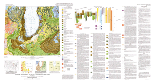
    The Quaternary Geologic Map of the Chicago 4 Degree x 6 Degree Quadrangle, United States, I-1420 (NK-16) was compiled by Jerry A. Lineback, Illinois State Geological Survey, Ned K. Bleuer, Indiana Geological Survey, David M. Mickelson, Department of Geology and Geophysics, University of Wisconsin, William R. Farrand, Department of Geological Sciences, University of Michigan, and Richard P. Goldthwait, Department of Geology and Mineralogy, Ohio State University. The state compilations were edited and integrated by Gerald M. Richmond and David S. Fullerton, U.S. Geological Survey. The compilations of geology and glacial features were converted to digital form by Techni Graphic Systems, Inc., of Fort Collins, CO, under contract with the U.S. Geological Survey and modified by Charles A. Bush. The hydrography layer was prepared by Sharon Smith, U.S. Geological Survey. Illustrations, wordprocessor files, the topographic layer, and DLG coverages were prepared by Bush.
  3. To whom should users address questions about the data?
    Charles A. Bush
    U.S. Geological Survey
    Emeritus Geophysicist
    Mail Stop 913, Box 25046, Federal Center
    Lakewood, Colorado
    USA

    (303) 236-4723 (voice)
    (303) 236-0214 (FAX)
    cbush@usgs.gov

Why was the data set created?

In recent years, surficial deposits and materials have become the focus of much interest by scientists, environmentalists, governmental agencies, and the general public. They are the foundations of ecosystems, the materials that support plant growth and animal habitat, and the materials through which travels much of the water required for our agriculture, our industry, and our general well being. They also are materials that easily can become contaminated by pesticides, fertilizers, and toxic wastes. In this context, the value of the surficial geologic map is evident

How was the data set created?

  1. From what previous works were the data drawn?
    Richmond and Fullerton, 1983 (source 1 of 2)
    Gerald M. Richmond (ed.), David S. Fullerton (ed.), Jerry A. Lineback (comp.), Ned K. Bleuer, (comp.), David M. Mickelson (comp.), William R. Farrand (comp., and Richard P. Goldthwait (comp.), 1983, Quaternary Geologic Map of the Chicago 4° x 6° Quadrangle, United States: Miscellaneous Investigations Series I-1420 (NK-16), U.S. Geological Survey, Reston, Virginia.

    Type_of_Source_Media:
    mylar separates from printer's negatives for printed map
    Source_Scale_Denominator: 1000000
    Source_Contribution: Linework and point data for the data sets
    2MILDLG (source 2 of 2)
    U.S. Geological Survey, 1995, 1:2,000,000-scale Digital Line Graphs -Railroad, Roads, and Boundaries features: U.S. Geological Survey, Reston, Virginia.

    Type_of_Source_Media: online
    Source_Scale_Denominator: 2000000
    Source_Contribution: spatial and attribute information
  2. How were the data generated, processed, and modified?
    Date: 1999 (process 1 of 10)
    Digitizing contractor scanned source stable-base material for geology and glacial layers, vectorized scan, converted into ARC/INFO coverages and attributed files from published paper map, and produced check plots and coverages.
    Date: 2000 (process 2 of 10)
    Sharon Smith, U.S. Geological Survey, scanned source stable-base material for hydrology layer, vectorized scan, and converted into ARC/INFO coverage.
    Date: 2000 (process 3 of 10)
    Wallace K. Fisk, U.S. Geological Survey, scanned source stable- base material for topography layer, vectorized scan, and converted into ARC/INFO coverage.
    Date: 2001 (process 4 of 10)
    C.A. Bush acquired U.S. Geological Survey DLG 1:2,000,000 digital data for roads, railroads, and county boundaries. Data was obtained for individual states, combined, and clipped to cover only the area of the map. Since the files are intended only for the user's reference, and to reduce file size, all attributes were removed from the railroad coverage. All attributes were removed from the roads coverage except U.S. and State highway designations. All attributes were removed from the boundaries coverage except those containing state or county names. A coverage was created containing map boundaries and state and international boundaries. These coverages do not exactly match the base used in preparation of the original Quaternary Atlas map, but are included for the user's convenience.
    Date: 2001 (process 5 of 10)
    C.A. Bush created illustration of the index map on the paper map in a drawing program and changed it to reflect the status of conversion of Quaternary Geologic Atlas quadrangles to digital databases. Bush scanned loess distribution, glacial lobe chronology, state and province compilation responsibility and map unit correlation diagrams as given on the printed map and converted them to PDF format.
    Date: 2001 (process 6 of 10)
    Map unit descriptions and sources of information as given on the printed map were scanned and converted by an Optical Character Recognition computer program into text files and to PDF format(Bush).
    Date: 2001 (process 7 of 10)
    Coverages of geology and glacial features were checked and corrected or changed. Additional items were included in the attributes. AML's were created to plot the data. Plots were imported into graphics program to create a plot of the map (Bush).
    Date: 2001 (process 8 of 10)
    Original map was scanned and recreated as PDF file.
    Date: 2001 (process 9 of 10)
    Illustrations and text files were checked and edited by Bush.
    Date: 01-May-2002 (process 10 of 10)
    Creation of original metadata record Person who carried out this activity:
    Charles A. Bush
    U.S. Geological Survey
    Emeritus Geophysicist
    U.S. Geological Survey, MS913, Box 25046, Denver Federal
    Center
    Denver, CO
    USA

    (303) 236-4723 (voice)
    (303) 236-0214 (FAX)
    cbush@usgs.gov
  3. What similar or related data should the user be aware of?

How reliable are the data; what problems remain in the data set?

  1. How well have the observations been checked?
    Compilation of geologic data: The accuracy of the map data is dependent on (1) the accuracy of the original source data, (2) the accuracy of transfer of that data to larger scale bases by the compilers, (3) the procedures by which the compilers and the editor/integrator simplified or generalized the data, and (4) the procedures used by, and the objectivity exercised by, the editor/integrator in integration of adjacent parts of the map that were prepared by different compilers. Consequently, aspects of accuracy for the data set cannot be quantified.
    Digitization and attributing of compilation: Digitizing contractor scanned source stable-base material, vectorized scan, attributed files, and produced check plots and coverages. C.A. Bush proofread check plots and reviewed digital files; made final corrections as needed; produced graphical files and imported them into graphics program to prepare plot file; proofread cartographic product; prepared illustrations and word processing files of descriptions of map units and sources of information. The original paper map was scanned and recreated as PDF files. (The original map was thoroughly reviewed for conformity with U.S. Geological Survey editorial standards and stratigraphic nomenclature.)
  2. How accurate are the geographic locations?
    The accuracy of location of polygons, lines, and points is consistent with the map scale of 1:1,000,000.
  3. How accurate are the heights or depths?
  4. Where are the gaps in the data? What is missing?
    These coverages contain polygons for all the map units, lines for all the contacts and glacial features, and points for all the locations of localities and drumlins. All geologic data from the original map are expressed on this map. Any differences between elements on the original map and attributed polygons, arcs, and points in this database are inadvertent and should not be construed as deliberate alterations of the data.
  5. How consistent are the relationships among the observations, including topology?
    Polygon and chain-node topology are present. The ARC/INFO commands BUILD and CLEAN were run to ensure the topological consistency of the data set. All polygons are labeled and were tested by using the ARC/INFO command LABELERRORS. All polygons were checked for closure and intersections.

How can someone get a copy of the data set?

Are there legal restrictions on access or use of the data?
Access_Constraints: None
Use_Constraints:
Acknowledgment of the Quaternary Geologic Atlas of the United States of America and (or) the U.S. Geological Survey in products derived from these data will be appreciated.
  1. Who distributes the data set? (Distributor 1 of 1)
    U.S. Geological Survey, Geologic Division, Central Publications Group
    U.S. Geological Survey, MS902, Box 25046, Denver Federal
    Center
    Denver, CO
    USA

    (303) 236-7684 (voice)
    (303) 236-6287 (FAX)
    troudebush@usgs.gov
  2. What's the catalog number I need to order this data set? Miscellaneous Investigations Series Map I-1420 (NK-16), "Quaternary Geologic Map of the Chicago 4° × 6° Quadrangle, United States"
  3. What legal disclaimers am I supposed to read?
    Any use of trade, product, or firm names is for descriptive purposes only and does not imply endorsement by the U.S. Government. Although this data set has been used by the U.S. Geological Survey, no warranty, expressed or implied, is made by the USGS as to the accuracy and functioning of the data set and related material nor shall the fact of distribution constitute any such warranty, and no responsibility is assumed by the USGS in connection therewith.
  4. How can I download or order the data?

Who wrote the metadata?

Dates:
Last modified: 13-Jun-2016
Metadata author:
Peter N Schweitzer
USGS Midwest Area
Collection manager, USGS Geoscience Data Clearinghouse, http://geo-nsdi.er.usgs.gov/
Mail Stop 954
12201 Sunrise Valley Dr
Reston, VA
USA

703-648-6533 (voice)
703-648-6252 (FAX)
pschweitzer@usgs.gov
Metadata standard:
Content Standard for Digital Geospatial Metadata (FGDC-STD-001-1998)

This page is <https://geo-nsdi.er.usgs.gov/metadata/map-i/1420/NK-16/metadata.faq.html>
Generated by mp version 2.9.48 on Tue Jul 03 20:04:45 2018