Citation:
Citation_Information:
Originator: Plouff, Donald
Title:
Geophysical studies of the Crump Geyser known geothermal resource area, Oregon, in 1975
Publication_Date: 2006
Series_Information:
Series_Name: Open-File Report
Issue_Identification: 2006-1110
Publication_Information:
Publication_Place: Menlo Park, California
Publisher: Geological Survey (U.S.)
Online_Linkage: http://pubs.usgs.gov/of/2006/1110/
Description:
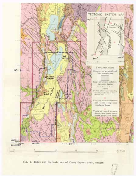
Abstract:
Gravity map and data used to infer details of the geologic structure of the area. Surveys were conducted during or prior to 1975.
Purpose:
Geophysical information republished in improved formats because the
information was otherwise difficult to obtain. Original study was
conducted in support of the resource appraisal of the Crump Geyser
Known Geothermal Resource Area (KGRA). This area was designated as a
KGRA by the USGS, and this designation became effective on December
24, 1970 (Godwin, and others, 1971). The land classification
standards for a KGRA were established by the Geothermal Steam Act of
1970 (Public Law 91-581). Federal lands so classified required
competitive leasing for the development of geothermal resources.
Time_Period_of_Content:
Time_Period_Information:
Multiple_Dates/Times:
Single_Date/Time:
Calendar_Date: 1975
Single_Date/Time:
Calendar_Date: 2006
Currentness_Reference: Original report of 1975 republished in 2006
Status:
Progress: Complete
Maintenance_and_Update_Frequency: None planned
Spatial_Domain:
Bounding_Coordinates:
West_Bounding_Coordinate: -120.081333
East_Bounding_Coordinate: -119.708333
North_Bounding_Coordinate: 42.445667
South_Bounding_Coordinate: 42.002167
Access_Constraints: none
Use_Constraints: none
Keywords:
Theme:
Theme_Keyword_Thesaurus: ISO 19115 Topic Categories
Theme_Keyword: geoscientificInformation
Theme:
Theme_Keyword_Thesaurus: Alexandria Digital Library Feature Type Thesaurus
Theme_Keyword: thermal features
Theme:
Theme_Keyword_Thesaurus: General glossary for mineral resources spatial data
Theme_Keyword: Portable Document Format
Theme:
Theme_Keyword_Thesaurus: USGS Thesaurus
Theme_Keyword: geophysics
Theme_Keyword: geologic structure
Theme_Keyword: geothermal resources
Theme_Keyword: gravimeter measurement
Theme_Keyword: gravitational field (earth)
Theme_Keyword: magnetic field (earth)
Theme_Keyword: geospatial datasets
Place:
Place_Keyword_Thesaurus: Augmented FIPS 10-4 and FIPS 6-4
Place_Keyword: f41037 = Lake
Point_of_Contact:
Contact_Information:
Contact_Person_Primary:
Contact_Person: Donald Plouff
Contact_Organization: USGS WR SW GD
Contact_Address:
Address_Type: mailing address
Address:
345 Middlefield Road
Mail Stop 989
City: Menlo Park
State_or_Province: CA
Postal_Code: 94025
Country: USA
Contact_Voice_Telephone: 650-329-5312
Contact_Facsimile_Telephone: 650-329-5490
Contact_Electronic_Mail_Address: plouff@usgs.gov
Browse_Graphic: