Geologic map and digital database of the Porcupine Wash 7.5 minute quadrangle, Riverside County, California

Metadata also available as - [Outline] - [Parseable text] - [XML]

Frequently anticipated questions:


What does this data set describe?

Title:
Geologic map and digital database of the Porcupine Wash 7.5 minute quadrangle, Riverside County, California
Abstract:
This data set maps and describes the geology of the Porcupine Wash 7.5 minute quadrangle, Riverside County, southern California. The quadrangle, situated in Joshua Tree National Park in the eastern Transverse Ranges physiographic and structural province, encompasses parts of the Hexie Mountains, Cottonwood Mountains, northern Eagle Mountains, and south flank of Pinto Basin. It is underlain by a basement terrane comprising Proterozoic metamorphic rocks, Mesozoic plutonic rocks, and Mesozoic and Mesozoic or Cenozoic hypabyssal dikes. The basement terrane is capped by a widespread Tertiary erosion surface preserved in remnants in the Eagle and Cottonwood Mountains and buried beneath Cenozoic deposits in Pinto Basin. Locally, Miocene basalt overlies the erosion surface. A sequence of at least three Quaternary pediments is planed into the north piedmont of the Eagle and Hexie Mountains, each in turn overlain by successively younger residual and alluvial deposits.
The Tertiary erosion surface is deformed and broken by north-northwest-trending, high-angle, dip-slip faults and an east-west trending system of high-angle dip- and left-slip faults. East-west trending faults are younger than and perhaps in part coeval with faults of the northwest-trending set.
The Porcupine Wash database was created using ARCVIEW and ARC/INFO, which are geographical information system (GIS) software products of Envronmental Systems Research Institute (ESRI). The database consists of the following items: (1) a map coverage showing faults and geologic contacts and units, (2) a separate coverage showing dikes, (3) a coverage showing structural data, (4) a scanned topographic base at a scale of 1:24,000, and (5) attribute tables for geologic units (polygons and regions), contacts (arcs), and site-specific data (points). The database, accompanied by a pamphlet file and this metadata file, also includes the following graphic and text products: (1) A portable document file (.pdf) containing a navigable graphic of the geologic map on a 1:24,000 topographic base. The map is accompanied by a marginal explanation consisting of a Description of Map and Database Units (DMU), a Correlation of Map and Database Units (CMU), and a key to point-and line-symbols. (2) Separate .pdf files of the DMU and CMU, individually. (3) A PostScript graphic-file containing the geologic map on a 1:24,000 topographic base accompanied by the marginal explanation. (4) A pamphlet that describes the database and how to access it. Within the database, geologic contacts , faults, and dikes are represented as lines (arcs), geologic units as polygons and regions, and site-specific data as points. Polygon, arc, and point attribute tables (.pat, .aat, and .pat, respectively) uniquely identify each geologic datum and link it to other tables (.rel) that provide more detailed geologic information.
Supplemental_Information:
Map nomenclature and symbols
Within the geologic map database, map units are identified by standard geologic map criteria such as formation-name, age, and lithology. The authors have attempted to adhere to the stratigraphic nomenclature of the U.S. Geological Survey and the North American Stratigraphic Code, but the database has not received a formal editorial review of geologic names.
Special symbols are associated with some map units. Question marks have been added to the unit symbol (e.g., QTs?, Prpgd?) and unit name where unit assignment based on interpretation of aerial photographs is uncertain. Question marks are plotted as part of the map unit symbol for those polygons to which they apply, but they are not shown in the CMU or DMU unless all polygons of a given unit are queried. To locate queried map-unit polygons in a search of database, the question mark must be included as part of the unit symbol.
Geologic map unit labels entered in database items LABL and PLABL contain substitute characters for conventional stratigraphic age symbols: Proterozoic appears as 'Pr' in LABL and as '<' in PLABL, Triassic appears as 'Tr' in LABL and as '^' in PLABL. The substitute characters in PLABL invoke their corresponding symbols from the GeoAge font group to generate map unit labels with conventional stratigraphic symbols.
  1. How might this data set be cited?
    Powell, Robert E., and Pamela M. Cossette (digital cartography), 2001, Geologic map and digital database of the Porcupine Wash 7.5 minute quadrangle, Riverside County, California: U.S. Geological Survey Open-File Report USGS OF 01-30, U.S. Geological Survey, Menlo Park, California.

    Online Links:

  2. What geographic area does the data set cover?
    West_Bounding_Coordinate: -115.87509096
    East_Bounding_Coordinate: -115.74990904
    North_Bounding_Coordinate: 33.87499995
    South_Bounding_Coordinate: 33.7499842
  3. What does it look like?
    http://pubs.usgs.gov/of/2001/0030/images/coverthb.jpg (JPG)
    Non-navigable image of the geologic map, topographic base, Correlation of Map and Database Units, Description of Map and Database Units and key to point and line symbols. 64 kilobytes.
    http://pubs.usgs.gov/of/2001/0030/pdf/pwash_map.pdf (PDF)
    Navigable portable document file (.pdf) image of the geologic map, topographic base, Correlation of Map and Database Units, Description of Map and Database Units and key to point and line symbols. 5.4 megabytes.
  4. Does the data set describe conditions during a particular time period?
    Beginning_Date: 1973
    Ending_Date: 2000
    Currentness_Reference:
    New data
  5. What is the general form of this data set?
    Geospatial_Data_Presentation_Form: Vector digital data
  6. How does the data set represent geographic features?
    1. How are geographic features stored in the data set?
      This is a Vector data set. It contains the following vector data types (SDTS terminology):
      • Point (2587)
      • String (6166)
      • GT-polygon composed of chains (2588)
    2. What coordinate system is used to represent geographic features?
      The map projection used is Polyconic.
      Projection parameters:
      Longitude_of_Central_Meridian: -115.8125
      Latitude_of_Projection_Origin: 33.75
      False_Easting: 0.00000
      False_Northing: 0.00000
      Planar coordinates are encoded using coordinate pair
      Abscissae (x-coordinates) are specified to the nearest 0.000001
      Ordinates (y-coordinates) are specified to the nearest 0.000001
      Planar coordinates are specified in Meters
      The horizontal datum used is North American Datum of 1927.
      The ellipsoid used is Clarke 1866.
      The semi-major axis of the ellipsoid used is 6378206.4.
      The flattening of the ellipsoid used is 1/294.98.
  7. How does the data set describe geographic features?
    Entity_and_Attribute_Overview:
    The Geologic Map and Digital Database of the Porcupine Wash 7.5 minute quadrangle includes five geospatial datasets as ARC/INFO coverages: pwash_geo (geology), pwash_dk (dikes), pwash_str (structural point data), pwash_orn (structural line ornamentation), and pwash_ldr (annotation leaders). Geospatial entities in ARC/INFO coverages have the following software-defined attributes: <cover>.pat contains AREA, PERIMETER, cover#, and cover-ID; <cover>.aat contains FNODE#, TNODE#, LPOLY#, RPOLY#, LENGTH, cover#, and cover-ID. User-defined attributes are described in detail below and in the Porcupine Wash Open-File Report from which this metadata is derived.
    (1) The coverage pwash_geo includes the following feature attribute tables: (a) a polygon feature attribute table (pwash_geo.pat) that describes the geospatial distribution of rock units represented in the Postscript (.ps) and Portable Document Format (.pdf) plotfiles of the geologic maps; (b)region subclass attribute tables (pwash_geo.patmetunits, pwash_geo.patpedunits, pwash_geo.patplutunits, pwash_geo.patsedunits, pwash_geo.patveinunits, pwash_geo.patvolcunits) that describe all geologic units contained in the database; and (c) an arc feature attribute table (pwash_geo.aat) that describes the contacts and faults that bound rock-unit polygons. For display purposes in the .ps and .pdf geologic maps, the geology coverage includes two annotation subclasses: anno.geo, which contains unit labels derived from the coded item PLABL, and anno.fault, which contains formal fault names.
    (2) The coverage pwash_dk includes an arc attribute table (pwash_dk.aat) that describes hypabyssal dikes. Dikes are planar intrusive features that intersect the Earth's surface as linear features; they are represented as lines where their surface widths are too narrow to be represented as polygons at a scale of 1:24,000.
    (3) The coverage pwash_str includes a point attribute table (pwash_str.pat) that describes geologic structural point data, including the types and orientation of bedding, foliation, and lineation. An annotation subclass (anno.value) displays the dip or plunge values associated with point data.
    (4) The coverage pwash_orn includes a point attribute table (pw_ptsorn.pat) that describes structural line ornamentation. An annotation subclass (anno.line) displays the sense of movement on a fault.
    (5) The coverage pwash_ldr includes an arc attribute table (pwash_ldr.pat) that describes annotation leaders. Unit symbols that are placed outside the perimeter of a particular polygon identify that polygon with annotation leaders.
    Entity_and_Attribute_Detail_Citation:
    http://pubs.usgs.gov/of/2001/0030/
    A complete description of the polygon, line, and point data coding schemes is available in U.S. Geological Survey Open-File Reports 97-859, OFR 97-860, and OFR 97-861 (full source citations follow):
    Matti, J.C., Miller, F.K., Powell, R.E., Kennedy, S.A., Bunyapanasarn, T.P., Koukladas, Catherine, Hauser, R.M., and Cossette, P.M., 1997b, Geologic-point attributes for digital geologic-map databases produced by the Southern California Areal Mapping Project (SCAMP), Version 1.0: U.S.Geological Survey Open-File Report 97-859
    Matti, J.C., Miller, F.K., Powell, R.E., Kennedy, S.A., and Cossette, P.M., 1997c, Geologic-polygon attributes for digital geologic-map databases produced by the Southern California Areal Mapping Project (SCAMP), Version 1.0: U.S.Geological Survey Open-File Report 97-860
    Matti, J.C., Powell, R.E., Miller, F.K., Kennedy, S.A., Ruppert, K.R., Morton, G.L., and Cossette, P.M., 1997a, Geologic-line attributes for digital geologic-map databases produced by the Southern California Areal Mapping Project (SCAMP), Version 1.0: U.S.Geological Survey Open-File Report 97-861
    pwash_geo.pat
    Geologic units shown on geologic map in Postscript (.ps) and Portable Document Format (.pdf) files
    LABL
    Geologic map unit label. Plain text is substituted for conventional geologic age symbols (Pr for Proterozoic; Tr for Triassic) and unit label subscripts as shown on map
    ValueDefinition
    QaVery young alluvial deposits (late Holocene)
    Qa2Very young alluvial deposits, Unit 2 (late Holocene)
    Qa1Very young alluvial deposits, Unit 1 (late Holocene)
    Qyai3Young alluvial deposits, insensitive source, Unit 3 (late and (or) middle Holocene)
    Qyai2Young alluvial deposits, insensitive source, Unit 2 (middle Holocene)
    Qyai1Young alluvial deposits, insensitive source, Unit 1 (middle and (or) early Holocene and (or) latest Pleistocene?)
    Qyas2,3Young alluvial deposits, sensitive source, Units 2 and 3 (late and (or) middle Holocene)
    Qyas3Young alluvial deposits, sensitive source, Unit 3 (late and (or) middle Holocene)
    Qyas2Young alluvial deposits, sensitive source, Unit 2 (late and (or) middle Holocene)
    Qyas2?Young alluvial deposits, sensitive source, Unit 2? (late and (or) middle Holocene)
    QyaosYoung alluvial deposits, oxidized, sensitive source (Holocene and latest Pleistocene?)
    Qoai3Old alluvial deposits, insensitive source, Unit 3 (late Pleistocene)
    Qoai2Old alluvial deposits, insensitive source, Unit 2 (middle? Pleistocene)
    QoapsOld alluvial deposits, pavemented, sensitive source (late Pleistocene)
    QoaosOld alluvial deposits, oxidized, sensitive source (middle? Pleistocene)
    Qoaos?Old alluvial deposits, oxidized, sensitive source? (middle? Pleistocene)
    QoarsOld alluvial and (or) regolithic deposits, sensitive source (middle? Pleistocene)
    QocOld colluvial deposits (Pleistocene)
    Qoc1,2Old colluvial deposits, Units 1 and 2 (Pleistocene)
    QovorkOld and (or) very old regolithic deposits, cemented (middle? and (or) early? Pleistocene)
    QvoaVery old alluvial deposits (middle and early Pleistocene)
    QTs?Sedimentary deposits? (Quaternary and (or) Tertiary)
    QTrcpRegolith, monzogranite of Cottonwood Pass (Quaternary and Tertiary)
    QTrcp?Regolith, monzogranite of Cottonwood Pass? (Quaternary and Tertiary)
    QTrpbRegolith, granodiorite of Pinto Basin (Quaternary and Tertiary)
    QTrpb?Regolith, granodiorite of Pinto Basin? (Quaternary and Tertiary)
    QTrpRegolith, Pinto Gneiss (Quaternary and Tertiary)
    TrscpSaprolite, monzogranite of Cottonwood Pass (Tertiary)
    Trscp?Saprolite, monzogranite of Cottonwood Pass? (Tertiary)
    KJmgccpMonzogranite of Cottonwood Pass (Cretaceous or Jurassic)
    KJmgccp?Monzogranite of Cottonwood Pass? (Cretaceous or Jurassic)
    KgdpbGranodiorite of Pinto Basin (Cretaceous)
    Kgdpb?Granodiorite of Pinto Basin? (Cretaceous)
    TrPmcMonzodiorite of Munsen Canyon (Triassic or Permian)
    PrmagAugen gneiss of Monument Mountain (Middle Proterozoic)
    PrpgPinto Gneiss of Miller, 1938 (Proterozoic)
    PrpgdPinto Gneiss, dark (Proterozoic)
    Prpgd?Pinto Gneiss, dark? (Proterozoic)
    PrpglPinto Gneiss, leucocratic granitic orthogneiss (Middle Proterozoic)
    Prpgl?Pinto Gneiss, leucocratic granitic orthogneiss? (Middle Proterozoic)
    PrppwSiliceous granofels of Wilson Canyon (Proterozoic)
    TKq?Quartz? (Tertiary or Cretaceous)
    TJh?Hypabyssal intrusive rocks? (Tertiary or Jurassic)
    PLABL
    Coded geologic map unit label used to generate plot label.
    SHDPS
    Coded integer that relates polygon to color in shadeset (scamp2.shd)
    SHDFIL
    Coded integer that relates polygon to fill pattern in shadeset (geology2.shd)
    NAME
    Geologic name of map unit (see list under LABL attribute)
    pwash_geo.patmetunits
    Metamorphic units contained in the database
    LABL
    Metamorphic unit label
    ValueDefinition
    PrhgcGneiss complex of Hexie Mountains (Proterozoic)
    PrmagAugen gneiss of Monument Mountain (Middle Proterozoic)
    PrmgPorphyritic granodiorite, monzogranite, and augen gneiss of Monument Mountain (Middle Proterozoic)
    PrpgPinto Gneiss of Miller, 1938 (Proterozoic)
    PrpgdPinto Gneiss, dark (Proterozoic)
    PrpglPinto Gneiss, leucocratic granitic orthogneiss (Middle Proterozoic)
    PrppMetsedimentary and (or) metamorphosed hydrothermally altered rocks of Pinkham Canyon (Proterozoic)
    PrppwSiliceous granofels of Wilson Canyon (Proterozoic)
    PARENT
    Label for metamorphic unit of next higher stratigraphic rank than that of unit indicated in LABL
    CHILD
    Labels for metamorphic units of lower stratigraphic rank than that of unit indicated in LABL
    UTYPE
    Class of geologic unit
    NAME
    Name of metamorphic unit
    AGE
    Age of metamorphic unit
    PLABL
    Coded geologic map unit label used to generate plot label.
    SHDPS
    Coded integer that relates polygon to color in shadeset scamp2.shd
    SHDFIL
    Coded integer that relates polygon to fill pattern in shadeset geology2.shd
    pwash_geo.patpedunits
    Pedogenic units contained in the database
    LABL
    Pedogenic unit label
    ValueDefinition
    QovorkOld and (or) very old regolithic deposits, cemented (middle? and (or) early? Pleistocene)
    QTrRegolith (Quaternary and Tertiary)
    QTrmgcRegolith, coarse-grained monzogranite (Quaternary and Tertiary)
    QTrcpRegolith, monzogranite of Cottonwood Pass (Quaternary and Tertiary)
    QTrgdRegolith, granodiorite (Quaternary and Tertiary)
    QTrpbRegolith, granodiorite of Pinto Basin (Quaternary and Tertiary)
    QTrpRegolith, Pinto Gneiss (Quaternary and Tertiary)
    TrRegolith (Tertiary)
    TrsSaprolite (Tertiary)
    TrscpSaprolite, monzogranite of Cottonwood Pass (Tertiary)
    PARENT
    Label for pedogenic unit of next higher stratigraphic rank than that of unit indicated in LABL
    CHILD
    Labels for pedogenic units of lower stratigraphic rank than that of unit indicated in LABL
    UTYPE
    Class of geologic unit
    NAME
    Name of pedogenic unit
    AGE
    Age of pedogenic unit
    PLABL
    Coded geologic map unit label used to generate plot label.
    SHDPS
    Coded integer that relates polygon to color in shadeset scamp2.shd
    SHDFIL
    Coded integer that relates polygon to fill pattern in shadeset geology2.shd
    pwash_geo.patplutunits
    Plutonic units contained in the database
    LABL
    Plutonic unit label
    ValueDefinition
    KJmgcMonzogranite, coarse-grained (Cretaceous and (or) Jurassic)
    KJmgccpMonzogranite of Cottonwood Pass (Cretaceous or Jurassic)
    KgdGranodiorite (Cretaceous)
    KgdpbGranodiorite of Pinto Basin (Cretaceous)
    TrPmcMonzodiorite of Munsen Canyon (Triassic or Permian)
    MzbcBatholith of Transverse Ranges and Mojave Desert, central belt (Mesozoic)
    MzbBatholith of Transverse Ranges and Mojave Desert (Mesozoic)
    PrmagAugen gneiss of Monument Mountain (Middle Proterozoic)
    PrmgPorphyritic granodiorite, monzogranite, and augen gneiss of Monument Mountain (Middle Proterozoic)
    PrpggPorphyritic granitoids and augen gneiss (Middle Proterozoic)
    PrpglPinto Gneiss, leucocratic granitic orthogneiss (Middle Proterozoic)
    PARENT
    Label for plutonic unit of next higher stratigraphic rank than that of unit indicated in LABL
    CHILD
    Labels for plutonic units of lower stratigraphic rank than that of unit indicated in LABL
    UTYPE
    Class of geologic unit
    NAME
    Name of plutonic unit
    AGE
    Age of plutonic unit
    PLABL
    Coded geologic map unit label used to generate plot label.
    SHDPS
    Coded integer that relates polygon to color in shadeset scamp2.shd
    SHDFIL
    Coded integer that relates polygon to fill pattern in shadeset geology2.shd
    pwash_geo.patsedunits
    Sedimentary units contained in the database
    LABL
    Sedimentary unit label
    ValueDefinition
    QaVery young alluvial deposits (late Holocene)
    Qa2Very young alluvial deposits, Unit 2 (late Holocene)
    Qa1Very young alluvial deposits, Unit 1 (late Holocene)
    QyaYoung alluvial deposits (Holocene and latest Pleistocene?)
    QyaiYoung alluvial deposits, insensitive source (Holocene and latest Pleistocene?)
    Qyai3Young alluvial deposits, insensitive source, Unit 3 (late and (or) middle Holocene)
    Qyai2Young alluvial deposits, insensitive source, Unit 2 (middle Holocene)
    Qyai1Young alluvial deposits, insensitive source, Unit 1 (middle and (or) early Holocene and (or) latest Pleistocene?)
    QyasYoung alluvial deposits, sensitive source (Holocene and latest Pleistocene?)
    Qyas2,3Young alluvial deposits, sensitive source, Units 2 and 3 (late and (or) middle Holocene)
    Qyas3Young alluvial deposits, sensitive source, Unit 3 (late and (or) middle Holocene)
    Qyas2Young alluvial deposits, sensitive source, Unit 2 (late and (or) middle Holocene)
    Qyas2?Young alluvial deposits, sensitive source, Unit 2? (late and (or) middle Holocene)
    QyaosYoung alluvial deposits, oxidized, sensitive source (Holocene and latest Pleistocene?)
    QyuaVery young and young alluvial deposits (Holocene)
    Qoaos?Old alluvial deposits, oxidized, sensitive source? (middle? Pleistocene)
    QoaOld alluvial deposits (Pleistocene)
    QoaiOld alluvial deposits, insensitive source (Pleistocene)
    Qoai3Old alluvial deposits, insensitive source, Unit 3 (late Pleistocene)
    Qoai2Old alluvial deposits, insensitive source, Unit 2 (middle? Pleistocene)
    QoasOld alluvial deposits, sensitive source (Pleistocene)
    QoapsOld alluvial deposits, pavemented, sensitive source (late Pleistocene)
    QoaosOld alluvial deposits, oxidized, sensitive source (middle? Pleistocene)
    QoarsOld alluvial and (or) regolithic deposits, sensitive source (middle? Pleistocene)
    QouaOld and very old alluvial deposits, undivided (Pleistocene)
    QocOld colluvial deposits (Pleistocene)
    Qoc1,2Old colluvial deposits, Units 1 and 2 (Pleistocene)
    QovorkOld and (or) very old regolithic deposits, cemented (middle? and (or) early? Pleistocene)
    QvoaVery old alluvial deposits (middle and early Pleistocene)
    QTs?Sedimentary deposits? (Quaternary and (or) Tertiary)
    PARENT
    Label for sedimentary unit of next higher stratigraphic rank than that of unit indicated in LABL
    CHILD
    Labels for sedimentary units of lower stratigraphic rank than that of unit indicated in LABL
    UTYPE
    Class of geologic unit
    NAME
    Name of sedimentary unit
    AGE
    Age of sedimentary unit
    PLABL
    Coded geologic map unit label used to generate plot label.
    SHDPS
    Coded integer that relates polygon to color in shadeset scamp2.shd
    SHDFIL
    Coded integer that relates polygon to fill pattern in shadeset geology2.shd
    pwash_geo.patveinunits
    Hydrothermal vein units contained in the database
    LABL
    Hydrothermal vein unit label
    ValueDefinition
    TKq?Quartz? (Tertiary or Cretaceous)
    PARENT
    Label for hydrothermal vein unit of next higher stratigraphic rank than that of unit indicated in LABL
    CHILD
    Labels for hydrothermal vein units of lower stratigraphic rank than that of unit indicated in LABL
    UTYPE
    Class of geologic unit
    NAME
    Name of hydrothermal vein unit
    AGE
    Age of hydrothermal vein unit
    PLABL
    Coded geologic map unit label used to generate plot label.
    SHDPS
    Coded integer that relates polygon to color in shadeset scamp2.shd
    SHDFIL
    Coded integer that relates polygon to fill pattern in shadeset geology2.shd
    pwash_geo.patvolcunits
    Volcanic and hypabyssal units contained in the database
    LABL
    Volcanic or hypabyssal unit label
    ValueDefinition
    TJh?Hypabyssal intrusive rocks? (Tertiary or Jurassic)
    PARENT
    Label for volcanic or hypabyssal unit of next higher stratigraphic rank than that of unit indicated in LABL
    CHILD
    Labels for volcanic or hypabyssal units of lower stratigraphic rank than that of unit indicated in LABL
    UTYPE
    Class of geologic unit
    NAME
    Name of volcanic or hypabyssal unit
    AGE
    Age of volcanic or hypabyssal unit
    PLABL
    Coded geologic map unit label used to generate plot label.
    SHDPS
    Coded integer that relates polygon to color in shadeset scamp2.shd
    SHDFIL
    Coded integer that relates polygon to fill pattern in shadeset geology2.shd
    pwash_geo.aat
    Geologic contacts and faults that bound rock-unit polygons
    LTYPE
    Linear geologic feature type
    CONTACT_RL
    Contact class
    MPR_CNT_RL
    L_NAME
    Formal name of linear geologic feature
    L_AGE
    Geologic age of linear feature
    FAULT_RL
    Fault class
    FAULT
    Fault strand
    L-SYMB
    Coded integer symbol that relates arc to cartographic line symbol in lineset look-up table (geoscamp2.lin)
    L-TAG
    Coded alpha-numerical symbol that relates arc to definition of line type in dictionary look-up table (lines.rel). For description of attributes in line classification dictionary, refer to USGS Open-File Report 97-861 (see Entity_and_Attribute_Detail_Citation)
    labl
    Geologic map unit label, in plain text
    LABL
    Geologic map unit label, in plain text
    ValueDefinition
    QopbOld pedogenic B-horizon (middle? Pleistocene)
    pwash_dk.aat
    Dikes
    LTYPE
    Linear feature type
    LABL
    Geologic map unit label, in plain text
    ValueDefinition
    TKdpDacite porphyry dike (Tertiary or Cretaceous)
    TJdDike (Tertiary, Cretaceous, or Jurassic)
    KapAplite dike (Cretaceous)
    L-SYMB
    Coded integer symbol that relates arc to cartographic line symbol in lineset look-up table (geoscamp2.lin)
    pwash_str.pat
    Structural point data
    P-TAG
    Coded alpha-numerical symbol that relates point to definition of point type in dictionary look-up table (points.rel). For description of attributes in point classification dictionary, refer to USGS Open-File Report 97-859 (see Entity_and_Attribute_Detail_Citation)
    P-SYMB
    Coded integer symbol that relates point to cartographic point symbol in markerset look-up table (geoscamp2.mrk)
    P-STRIKE
    Azimuthal strike of planar feature
    P-DIP
    Dip of planar feature
    P-DIPDIR
    Azimuthal direction of dip of planar feature
    P-PLUNGE
    Plunge of linear feature
    P-BEARING
    Azimuthal direction of plunge of linear feature
    P-SOURCE
    Source of data
    pw_ptsorn.pat
    Line ornamentation
    P-TAG
    Coded alpha-numerical symbol that relates point to definition of point type in dictionary look-up table (points.rel). For description of attributes in point classification dictionary, refer to USGS Open-File Report 97-859 (see Entity_and_Attribute_Detail_Citation)
    P-SYMB
    Coded integer symbol that relates point to cartographic point symbol in markerset look-up table (geoscamp2.mrk)
    pwash_ldr.aat
    Annotation leader
    L-SYMB
    Coded integer symbol (1) that relates arcs to cartographic line symbol in lineset look-up table (geoscamp2.lin)

Who produced the data set?

  1. Who are the originators of the data set? (may include formal authors, digital compilers, and editors)
    • Robert E. Powell
    • Pamela M. Cossette (digital cartography)
  2. Who also contributed to the data set?
    Geologic mapping, topical studies, and digital preparation for this report were sponsored jointly by the following: (1) the National Cooperative Geologic Mapping Program of the U.S. Geological Survey, (2) California Division of Mines and Geology, and (3) the National Park Service (Joshua Tree National Park).
    This database was prepared in the GIS laboratory at the Spokane Field Office of the USGS in Spokane, Washington. The facility is maintained primarily by the Mineral Resource Surveys Program and supported in part by the National Geologic Mapping Program. We thank Paul C. Hyndman and Steven R. Munts in Spokane and Rachel Hauser Alvarez of the SCAMP GIS laboratory at the University of California, Riverside for their assistance in solving problems encountered during digital preparation of the data set.
    Technical review by Jonathan C. Matti has led to significant improvements in the database and in the map plot file. Todd T. Fitzgibbon has examined the digital database file for internal logical consistency, has reviewed the metadata file, and has tested the viability of digital products.
  3. To whom should users address questions about the data?
    Robert E. Powell
    U.S.Geological Survey, Western Region, Earth Surface Processes Team
    Project geologist
    U.S. Geological Survey
    Room 202
    West 904 Riverside Avenue
    Spokane, Washington
    USA

    (509) 368-3120 (voice)
    (509) 368-3199 (FAX)
    rpowell@usgs.gov

Why was the data set created?

The data set for the Porcupine Wash quadrangle has been prepared by the Southern California Areal Mapping Project (SCAMP), a cooperative project sponsored jointly by the U.S. Geological Survey and the California Division of Mines and Geology. The Porcupine Wash data set represents part of an ongoing effort to create a regional GIS geologic database for southern California. This regional digital database, in turn, is being developed as a contribution to the National Geologic Map Database of the National Cooperative Geologic Mapping Program of the USGS. The Porcupine Wash database has been prepared in cooperation with the National Park Service as part of an ongoing project to provide Joshua Tree National Park with a geologic map base for use in managing Park resources and developing interpretive materials.
The digital geologic map database for the Porcupine Wash quadrangle has been created as a general-purpose data set that is applicable to land-related investigations in the earth and biological sciences. Along with geologic map databases in preparation for adjoining quadrangles, the Porcupine Wash database has been generated to further our understanding of bedrock and surficial processes at work in the region and to document evidence for seismotectonic activity in the eastern Transverse Ranges. The database is designed to serve as a base layer suitable for ecosystem and mineral resource assessment and for building a hydrogeologic framework for Pinto Basin.

How was the data set created?

  1. From what previous works were the data drawn?
  2. How were the data generated, processed, and modified?
    Date: 1973 (process 1 of 8)
    Geologic mapping for Ph.D. dissertation, supported in part by U.S. Geological Survey (Powell, 1981). Bedrock units and faults mapped in field on 1:36,000 true-color aerial photographs (USGS, 1973), compiled onto a 1:62,500 topographic base map of the Hexie Mountains 15' quadrangle (1963, paper copy), then reduced onto a 125,000 topographic base (base-stable mylar greenline). Bedrock units in the Hexie Mountains quadrangle were mapped, described, and interpreted by conducting field traverses and interpolating between the traverses by interpretation of aerial photographs. This mapping was part of a regional study of the geology and structure of the eastern Transverse Ranges province south of the Pinto Mountain fault. The southeast quarter of the Hexie Mountains quadrangle topographic map has subsequently been published as the Porcupine Wash 7.5' quadrangle (provisional edition, 1986).
    Powell, R.E., 1981, Geology of the crystalline basement complex, eastern Transverse Ranges, southern California: Constraints on regional tectonic interpretation [Ph.D. thesis]: Pasadena, California Institute of Technology, 441 p.
    USGS, 1973, True color aerial photographs labeled GS-SE. Photographs taken along northwest-southeast oriented flight lines covering the eastern Transverse Ranges south of the Pinto Mountain fault. Lines flown at moderate to low sun-angle in October 1973; scale 1:36,000.
    Date: 1982 (process 2 of 8)
    Additional observations were made in bedrock units of the Hexie Mountains quadrangle during the course of ongoing geologic studies in the eastern Transverse Ranges province (Powell, 1993).
    Powell, R.E., 1993, Balanced palinspastic reconstruction of pre-late Cenozoic paleogeology, southern California: Geologic and kinematic constraints on evolution of the San Andreas fault system, in Powell, R.E., Weldon, R.J., II, and Matti, J.C., eds., The San Andreas fault system: Displacement, palinspastic reconstruction, and geologic evolution: Geological Society of America Memoir 178, p. 1-106.
    Date: 1997 (process 3 of 8)
    The geologic map and database for the Porcupine Wash quadrangle was generated by combining the bedrock mapping of previous process-steps with new, larger-scale mapping both of bedrock units and surficial deposits. The new mapping is based chiefly on interpretation of 1:24,000 color photographs (USGS, 1998), 1:40,000 NAPP infrared color photographs (USGS, 1996), and 1:80,000 NHAP infrared color photographs (USGS, 1983-1984) with minimal new fieldwork at this stage. Using ARCVIEW and its Image Analysis extension, geologic contacts, faults, and dikes were mapped on georeferenced USGS digital orthophotograph quarter quadrangles (DOQQs). The lines generated in ARCVIEW were assigned basic attributes and exported to ARCINFO where a line-polygon coverage was generated for the geology layer. This coverage was exported back to ARCVIEW as line and polygon shape files. Polygons were assigned their basic attributes in ARCVIEW and re-exported to ARCINFO for more complete attribution in the full coverage. Polygons in the coverage are attributed to generate the plot-file map. These plot-file map units, as well as other mapped units and aggregates of units that are included in the database but not shown on the plot-file map, are further attributed as region features (groups of polygons).
    USGS, 1998, True color aerial photographs labeled J.T.N.P. Photographs taken along east-west oriented flight lines covering part of Joshua Tree National Park in Pinto Basin and parts of the Coxcomb, Pinto, Eagle, Cottonwood, Hexie, and Little San Bernardino Mountains. Lines flown at high sun-angle in May 1998; scale 1:24,000.
    Date: 2000 (process 4 of 8)
    The source of the base hypsography, hydrography, and culture for the geologic map is the U.S. Geological Survey, 1:24,000-scale topographic map of the Porcupine Wash 7.5 minute quadangle (provisional edition, 1986). The topographic map was photographically reproduced on scale-stable clear film. The resulting blackline photo-positive image was scanned at 500 dpi using an Anatech Eagle 4080 monochrome 800 dpi rasterizing scanner. The raster scan was imported into ARC/INFO, registered and rectified to the Porcupine Wash quadrangle, and saved in GEOTIFF format. Topographic elements on the base map are geospatially located by this process, but no features are attributed. The topographic base map is provided for locational reference only.
    Date: 2000 (process 5 of 8)
    To provide a topographic base for the geologic map, the monochromatic raster scan file and the geologic map coverages were converted to ARC/INFO grids, merged, resulting in the topographic and cultural information drawn in gray and the geologic map unit colors drawn with their respective colors. The combined map is a digital image in which geologic and topographic lines and points are displayed in their proper geospatial locations, but for which no information other than location is attached to the lines and points.
    Date: 2000 (process 6 of 8)
    Structural measurements of foliation and fold axes orientation taken from unpublished geologic map of the Hexie Mountains 15' quadrangle by R. A. Hope (U.S. Geological Survey, 1964-1969).
    Date: 19-Dec-2000 (process 7 of 8)
    First draft of metadata created by Pamela M.Cossette using FGDCMETA.AML ver. 1.2 05/14/98 on ARC/INFO data set /pool1/cossette/1_joshua/1_porc/pw_1219
    Date: 23-Feb-2001 (process 8 of 8)
    Creation of original metadata record Person who carried out this activity:
    U.S. Geological Survey
    Attn: Pamela M. Cossette
    Geographer
    U.S. Geological Survey
    West 904 Riverside Avenue
    Spokane, Washington
    USA

    509-368-3123 (voice)
    509-368-3199 (FAX)
    pcossette@usgs.gov
  3. What similar or related data should the user be aware of?
    Powell, Robert E., 2001, Geologic map and digital database of the Conejo Well 7.5 minute quadrangle, Riverside County, California: U.S. Geological Survey Open-File Report USGS OF 01-31, U.S. Geological Survey, Menlo park, California.

    Online Links:


How reliable are the data; what problems remain in the data set?

  1. How well have the observations been checked?
    This initial version of the Porcupine Wash geologic map database relies extensively on interpretation of aerial photographs; field study of bedrock units was conducted in the context of smaller-scale regional mapping and field study of surficial deposits has been minimal. The map represents the state of knowledge for the quadrangle and provides a basis for gathering additional field data to resolve questions raised in making the map. Attributes assigned to regions, polygons, lines, and points in the Porcupine Wash database are reasonably accurate as determined by the normal range of checks and balances applied in making a geologic map by a combination of hands-on and remote field observation, sampling, and interpretation of aerial photographs. Additional field investigation, however, is required to verify the accuracy of polygon (map unit) attributes and to establish relations among units. Where anomalous descriptive characteristics lead to particular uncertainty of unit assignment of a polygon, a question mark (?) is appended to the unit label. In the Porcupine Wash quadrangle, this device has been used chiefly for unit assignments of unvisited polygons that appear anomalous on aerial photographs.
  2. How accurate are the geographic locations?
    Geologic lines and points on 1:24,000 scale geologic maps are judged to meet map-accuracy standards if they are located to within +/-15 meters, relative to topographic or cultural features on the base map. Lines and points that meet (or may not meet) this map-accuracy standard are identified both in the digital database and on derivative geologic-map plots. On geologic-map plots, line data that are judged to meet the map-accuracy standard are denoted by solid lines; line data that may not meet the map-accuracy standard are denoted by dashed or dotted lines.
    Contacts between lithologic domains that make up surficial deposits as mapped on the digital orthophotograph quarter quadrangles typically are readily located to within 15 meters, but to make domains that can be resolved at 1:24,000 contacts are often drawn by approximating the dominant unit on a percentage basis. Interspersal of well- and approximately located contacts is common among the many hundreds of contact segments present in the Porcupine Wash quadrangle. Given that many quadrangles are being mapped in a relatively short time interval, it was deemed too time-consuming to distinguish well-located and approximately located contacts between surficial deposits; therefore, all surficial contacts are represented as approximately located and shown with a dashed line symbol.
  3. How accurate are the heights or depths?
  4. Where are the gaps in the data? What is missing?
    The geologic map and digital database of the Porcupine Wash 7.5 minute quadrangle contain new data that have been subjected to rigorous review and are a substantially complete representation of the current state of knowledge concerning the geology of the quadrangle.
  5. How consistent are the relationships among the observations, including topology?
    Polygon and chain-node topology present.
    The areal extent of the map is represented digitally by an appropriately projected (Polyconic projection), mathematically generated box. Consequently, polygons intersecting the lines that comprise the map boundary are closed by that boundary. Polygons internal to the map boundary are completely enclosed by line segments which are themselves a set of sequentially numbered coordinate pairs. Point data are represented by coordinate pairs.

How can someone get a copy of the data set?

Are there legal restrictions on access or use of the data?
Access_Constraints: None
Use_Constraints:
Spatial Resolution. Use of this digital geologic map should not violate the spatial resolution of the data. The Porcupine Wash geologic map and database was developed using digital orthophotograph quarter quadrangles (DOQQs) as a base. DOQQs have a pixel resolution of 1 m and are accurate to a scale of 1:12,000 (1 in = 1,000 ft). Any enlargement beyond 1:12,000 exceeds the spatial resolution of the geologic data and should not be used in lieu of a more detailed site-specific geologic evaluation. Similarly, the digital topographic base map is derived from the U.S. Geological Survey, 1:24,000-scale Porcupoine Wash 7.5 minute quadrangle (provisional edition, 1986); any enlargement beyond 1:24,000 exceeds the spatial resolution of the topographic data. Plotting or viewing of the data at scales larger than 1:12,000 on the DOQQ base, or larger than 1:24,000 on the topographic base, will not yield greater real detail, although it may reveal fine-scale irregularities below the intended resolution of the database. Where the geologic data is used in combination with the topographic data, the resolution of the combined output is limited by the lower resolution of the topographic data. Where this database is used in combination with other data of higher resolution, the resolution of the combined output will be limited by the lower resolution of these data.
Content. This database, identified as "Geologic map and digital database of the Porcupine Wash 7.5 minute quadrangle, Riverside County, California" has been approved for release and publication by the Director of the U.S. Geological Survey. Although this database has been subjected to rigorous review and is substantially complete, the USGS reserves the right to revise the data pursuant to further analysis and review. Furthermore, it is released on the condition that neither the USGS nor the United States Government may be held responsible for any damages resulting from its authorized or unauthorized use. This database is preliminary and has not been reviewed for conformity with U.S. Geological Survey editorial standards or with the North American Stratigraphic Code. Any use of trade, product, or firm names is for descriptive purposes only and does not imply endorsement by the U.S. Government.
Faults. The Porcupine Wash database is sufficiently detailed to identify and characterize many actual and potential geologic hazards represented by faults, but it is not sufficiently detailed for site-specific determinations or evaluations of these features. Faults shown do not take the place of fault-rupture hazard zones designated by the California State Geologist (see, for example, Hart, 1988; Hart and Bryant, 1997).
Hart, E. W., 1988, Fault-rupture zones in California; Alquist-Priolo Special Studies Zones Act of 1972 with index to special studies zones maps (revised, 1988): California Division of Mines and Geology Special Publication 42.
Hart, E. W., and Bryant, W.A., 1997, Fault-rupture zones in California; Alquist-Priolo Special Studies Zones Act of 1972 with index to special studies zones maps (revised, 1997): California Division of Mines and Geology Special Publication 42.
  1. Who distributes the data set? (Distributor 1 of 1)
    U.S. Geological Survey Information Services
    Box 25286 Denver Federal Center
    Denver, CO
    USA

    303-202-4700 (voice)
    303-202-4693 (FAX)
  2. What's the catalog number I need to order this data set? USGS Open-File Report 01-30
  3. What legal disclaimers am I supposed to read?
    The U.S. Geological Survey (USGS) provides these geographic data "as is." The USGS makes no guarantee or warranty concerning the accuracy of information contained in the geographic data. The USGS further makes no warranties, either expressed or implied as to any other matter whatsoever, including, without limitation, the condition of the product, or its fitness for any particular purpose. The burden for determining fitness for use lies entirely with the user. Although these data have been processed successfully on computers at the USGS, no warranty, expressed or implied, is made by the USGS regarding the use of these data on any other system, nor does the fact of distribution constitute or imply any such warranty.
    In no event shall the USGS have any liability whatsoever for payment of any consequential, incidental, indirect, special, or tort damages of any kind, including, but not limited to, any loss of profits arising out of use of or reliance on the geographic data or arising out of delivery, installation, operation, or support by USGS.
    This digital, geologic map database of the Porcupine Wash 7.5'quadrangle, and any derivative maps thereof, is not meant to be used or displayed at any map scale larger than 1:12,000 on the DOQQ base or 1:24,000 on the topograhic base.
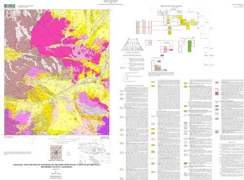
  4. How can I download or order the data?
    • Availability in digital form:
      Data format: Geologic polygons, lines, and symbols, and dictionary coverages, with additional text. in format ARCE (version 7.2.1) Size: 5.5
      Network links: http://pubs.usgs.gov/of/2001/0030/pwash.tar.gz
    • Cost to order the data: none


Who wrote the metadata?

Dates:
Last modified: 10-Jun-2016
Metadata author:
Peter N Schweitzer
USGS Midwest Area
Collection manager, USGS Geoscience Data Clearinghouse, http://geo-nsdi.er.usgs.gov/
Mail Stop 954
12201 Sunrise Valley Dr
Reston, VA
USA

703-648-6533 (voice)
703-648-6252 (FAX)
pschweitzer@usgs.gov
Metadata standard:
Content Standard for Digital Geospatial Metadata (FGDC-STD-001-1998)

This page is <https://geo-nsdi.er.usgs.gov/metadata/open-file/01-30/metadata.faq.html>
Generated by mp version 2.9.48 on Tue Jul 03 20:05:40 2018