Map and map database of susceptibility to slope failure by sliding and earthflow in the Oakland area, California

Metadata also available as - [Outline] - [Parseable text] - [XML]

Frequently anticipated questions:


What does this data set describe?

Title:
Map and map database of susceptibility to slope failure by sliding and earthflow in the Oakland area, California
Abstract:
Map data that predict the varying likelihood of landsliding can help public agencies make informed decisions on land use and zoning. This map, prepared in a geographic information system from a statistical model, estimates the relative likelihood of local slopes to fail by two processes common to an area of diverse geology, terrain, and land use centered on metropolitan Oakland. The model combines the following spatial data: (1) 120 bedrock and surficial geologic-map units, (2) ground slope calculated from a 30-m digital elevation model, (3) an inventory of 6,714 old landslide deposits (not distinguished by age or type of movement and excluding debris flows), and (4) the locations of 1,192 post-1970 landslides that damaged the built environment. The resulting index of likelihood, or susceptibility, plotted as a 1:50,000-scale map, is computed as a continuous variable over a large area (872 km2) at a comparatively fine (30 m) resolution. This new model complements landslide inventories by estimating susceptibility between existing landslide deposits, and improves upon prior susceptibility maps by quantifying the degree of susceptibility within those deposits.
Susceptibility is defined for each geologic-map unit as the spatial frequency (areal percentage) of terrain occupied by old landslide deposits, adjusted locally by steepness of the topography. Susceptibility of terrain between the old landslide deposits is read directly from a slope histogram for each geologic-map unit, as the percentage (0.00 to 0.90) of 30-m cells in each one-degree slope interval that coincides with the deposits.
Susceptibility within landslide deposits (0.00 to 1.33) is this same percentage raised by a multiplier (1.33) derived from the comparative frequency of recent failures within and outside the old deposits. Positive results from two evaluations of the model encourage its extension to the 10-county San Francisco Bay region and elsewhere. A similar map could be prepared for any area where the three basic constituents, a geologic map, a landslide inventory, and a slope map, are available in digital form. Added predictive power of the new susceptibility model may reside in attributes that remain to be explored-among them seismic shaking, distance to nearest road, and terrain elevation, aspect, relief, and curvature.
  1. How might this data set be cited?
    Pike, Richard J., Graymer, Russell W., Roberts, Sebastian, Kalman, Naomi B., and Sobieszczyk, Steven, 2001, Map and map database of susceptibility to slope failure by sliding and earthflow in the Oakland area, California: U.S. Geological Survey Miscellaneous Field Studies Map MF-2385, U.S. Geological Survey, Menlo Park, CA.

    Online Links:

  2. What geographic area does the data set cover?
    West_Bounding_Coordinate: -122.3750000
    East_Bounding_Coordinate: -122.0000000
    North_Bounding_Coordinate: 38.00000000
    South_Bounding_Coordinate: 37.62500000
  3. What does it look like?
    http://pubs.usgs.gov/mf/2002/2385/images/mf2385.gif (GIF)
    Image of entire map on white background
    http://pubs.usgs.gov/mf/2002/2385/mf-2385_6b.pdf (PDF)
    A PDF representation of the geologic map and base maps at a scale of 1:50,000 (Sheet 1). 13 megabytes.
  4. Does the data set describe conditions during a particular time period?
    Calendar_Date: 2001
    Currentness_Reference:
    The date given is the publication date. The information in the report is the most up-to-date available at the time of publication.
  5. What is the general form of this data set?
    Geospatial_Data_Presentation_Form: map
  6. How does the data set represent geographic features?
    1. How are geographic features stored in the data set?
      This is a Raster data set. It contains the following raster data types:
      • Dimensions 1394 x 1122, type grid cell
    2. What coordinate system is used to represent geographic features?
      Grid_Coordinate_System_Name: Universal Transverse Mercator
      Universal_Transverse_Mercator:
      UTM_Zone_Number: 10
      Transverse_Mercator:
      Scale_Factor_at_Central_Meridian: 0.9996
      Longitude_of_Central_Meridian: -123
      Latitude_of_Projection_Origin: 0.0
      False_Easting: 500000
      False_Northing: 0.0
      Planar coordinates are encoded using coordinate pair
      Abscissae (x-coordinates) are specified to the nearest 1.0
      Ordinates (y-coordinates) are specified to the nearest 1.0
      Planar coordinates are specified in METERS
      The horizontal datum used is North American Datum of 1927.
      The ellipsoid used is Clarke 1866.
      The semi-major axis of the ellipsoid used is 6378206.4.
      The flattening of the ellipsoid used is 1/294.98.
  7. How does the data set describe geographic features?
    grid cell
    grid cell of susgrd_utm
    (grid cell value)
    Susceptibility multiplied by 100 to generate an integer value.
    Susceptibility is defined for each geologic-map unit as the spatial frequency (areal percentage) of terrain occupied by old landslide deposits, adjusted locally by steepness of the topography. Susceptibility of terrain between the old landslide deposits is read directly from a slope histogram for each geologic-map unit, as the percentage (0.00 to 0.90) of 30-m cells in each one-degree slope interval that coincides with the deposits.
    Susceptibility within landslide deposits (0.00 to 1.33) is this same percentage raised by a multiplier (1.33) derived from the comparative frequency of recent failures within and outside the old deposits.
    Range of values
    Minimum:0
    Maximum:133
    Resolution:1
    susgrd_utm.VAT
    grid source data (Source: ARC/INFO)
    Record
    record number for cell
    Range of values
    Minimum:0
    Maximum:109
    Value
    assigned susceptibility cell
    Range of values
    Minimum:0
    Maximum:133
    Units:susceptibility
    Resolution:1
    Count
    Number of cells with same assigned value
    Range of values
    Minimum:12
    Maximum:345386
    Units:number of grid cells
    Resolution:1
    Entity_and_Attribute_Overview:
    The databases in this report were compiled in ARC/INFO, a commercial Geographic Information System (Environmental Systems Research Institute, Redlands, California). Almost all the attributes in the attribute table of the grid included in the report are set or calculated by Arc/Info. The only exception is "count." The boundary of the grid is xmin = 554596.775, xmax = 588256.775, ymin = 4164296.500, and ymax = 4206116.500. Statistics of the grid include a minimum value of 0, a maximum value of 133, which allows a mean of 13.24 and a standard deviation of 18.11. There are 110 values included and 8 bytes of attribute data.
    Entity_and_Attribute_Detail_Citation: http://pubs.usgs.gov/mf/2002/2385/mf-2385_2c.pdf

Who produced the data set?

  1. Who are the originators of the data set? (may include formal authors, digital compilers, and editors)
    • Pike, Richard J.
    • Graymer, Russell W.
    • Roberts, Sebastian
    • Kalman, Naomi B.
    • Sobieszczyk, Steven
  2. Who also contributed to the data set?
    Richard J. Pike (USGS) co-conceived the project and directed the overall effort, supplied ideas and topographic parameters to be experimented with by Sebastian Roberts, contributed to creating ( with Scott Graham, USGS) the 30-m digital elevation model, devised the final model, prepared the tables, decided on figures to be made, chose colors for map, and prepared all versions of the pamphlet text and designed its final layout.
    Russell W. Graymer (USGS) co-conceived the project and delimited the study area, supplied ideas to be experimented with by S. Roberts, furnished the digital geologic map and list of 120 map units, devised the first model for within-landslide susceptibility, conceived the tests of the model-particularly normalization of the post-1970 landslide data, and contributed to the pamphlet.
    Sebastian Roberts (USGS and Environmental Careers Organization) digitized the original 1:24,000-scale landslide maps and map positions of the post-1970 landslides, compiled the digital data on geology, ground slope, landslide inventory, recent landsliding, and land use in the Arc/Info geographic information system, wrote the Arc Macro Language (AML) to make computations, computed the first set of susceptibility values, and created the earliest versions of the 1:50,000-scale color map.
    Naomi B. Kalman (USGS and Environmental Careers Organization) recompiled data, adjusted the susceptibility and plot AMLs, computed the revised set of susceptibility values, made preliminary versions of pamphlet figures, based off her database files, produced intermediate versions of the map, and served as a resource for later work on the project.
    Steven Sobieszczyk (USGS and Environmental Careers Organization) recompiled some of the data, rewrote the plot AML, computed the revised susceptibility values, created or modified color and monochrome illustrations for the map and pamphlet, prepared the final versions of the map, annotated and reformatted the map to conform to USGS publication standards, and made corrections to the map after technical reviews. He wrote the metadata for the digital file, and helped format the pamphlet to conform to USGS publication standards.
  3. To whom should users address questions about the data?
    Richard J Pike
    U.S. Geological Survey, GEO-WRG-NGM
    Mail Stop 975
    345 Middlefield Road
    Menlo Park, CA
    USA

    650-329-4947 (voice)
    650-329-4936 (FAX)
    rpike@usgs.gov

Why was the data set created?

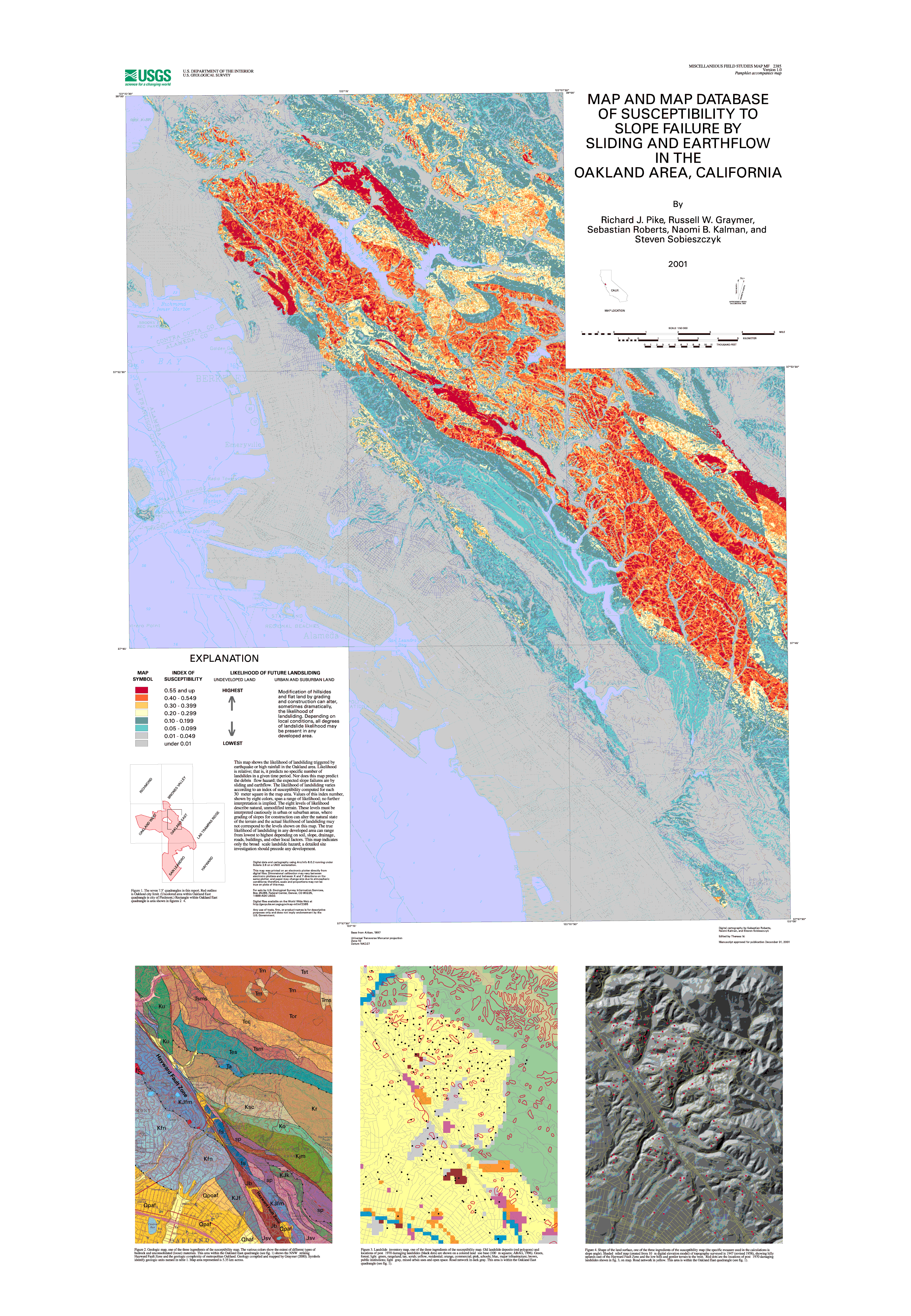
Mitigation is superior to post-disaster response in reducing the billions of dollars in losses resulting from U.S. natural disasters, and information that predicts the varying likelihood of geologic hazards can help public agencies improves the necessary decision making on land use and zoning. Accordingly, this map was created to increase the resistance of one urban area, metropolitan Oakland, California, to landsliding. Prepared in a geographic information system from a statistical model, the map estimates the relative likelihood of local slopes to fail by two processes common to this area of diverse geology, terrain, and land use.

How was the data set created?

  1. From what previous works were the data drawn?
    Nilsen, 1975 (source 1 of 3)
    Nilsen, Tor, 1975, Preliminary photo-interpretation maps of landslide and other surficial deposits of 56 7.5-minute quadrangles, Alameda, Contra Costa, and Santa Clara Counties, California: U.S. Geological Survey Open File Report 75-277.

    Type_of_Source_Media: paper
    Source_Scale_Denominator: 24000
    Source_Contribution: landslide inventory data
    Graymer, 2000 (source 2 of 3)
    Graymer, R.W., 2000, Geologic map and map database of the Oakland metropolitan area, Alameda, Contra Costa, and San Francisco Counties, California: U.S. Geological Survey Miscellaneous Field Studies Map MF-2342.

    Type_of_Source_Media: paper
    Source_Scale_Denominator: 50,000
    Source_Contribution: Geologic map of same region
    (source 3 of 3)
    U.S. Geological Survey, 19790701, DEM 7.5 Quadrangle: U.S. Geological Survey, Reston, VA.

    Other_Citation_Details:
    The photo source date for this DEM was 01-JAN-66 and it was last revised 01-JAN-98
  2. How were the data generated, processed, and modified?
    Date: 2000 (process 1 of 3)
    The databases in this report were compiled in ARC/INFO, a commercial Geographic Information System (Environmental Systems Research Institute, Redlands, California), with version 3.0 of the menu interface ALACARTE (Fitzgibbon and Wentworth, 1991, Fitzgibbon, 1991, Wentworth and Fitzgibbon, 1991). The files are either in GRID (ARC/INFO raster data) Format or in COVERAGE (Arc/Info vector data). The grid and coverages are stored in uncompressed ARC export format (ARC/INFO version 7.2). ARC/INFO export files (files with the .e00 extension) can be converted into an ARC/INFO grid in ARC/INFO (see below) and can be read by some other Geographic Information Systems, such as MapInfo via ArcLink and ESRI's ArcView (version 1.0 for Windows 3.11 is for free from ESRI's web site: http://www.esri.com). The digital compilation was done in version 7.2 of ARC/INFO with version 3.0 of the menu interface ALACARTE (Fitzgibbon and Wentworth, 1991, Fitzgibbon, 1991, Wentworth and Fitzgibbon, 1991).
    The original datasets were created from digitized mylar overlays of landslide inventories (ofr 75-277) created by Tor Nilsen, and digitized by Sebastian Roberts. These coverages were griddedand analysed using the Arc/Info GRID feature. An AML was written to create the susceptibility grid using USGS DEMs from the BARD website, the geology grid MF-2342, and the new landslide (ofr 75-277) grid. Five other coverage layers, not used for anaylsis were used as referencing layers for the final maps publication. These coverages include a water layer, a highway layer, a road network layer, a contour topography layer, and a cultural base map layer. This coverage layers are included with this publication to allow reproduction of finally map.
    Date: 2000 (process 2 of 3)
    Base maps
    Base Map layers used in the preparation of the landslide susceptibility map plotfiles were derived from published digital maps (Aitken, 1997). Below are export files of the five coverages used for the final version of the map. As mentioned early, these coverages are not used in any way for analysis, but are need for spatial placement.
    File name       coverage  contents
    MF-2385_5a.e00  drain     drainage base map for Oakland area
    MF-2385_5b.e00  culture   cultural base map, including names
    MF-2385_5c.e00  roads     street pattern and road network
    MF-2385_5d.e00  hwys      interstate highways
    MF-2385_5e.e00  hydro     streams, lakes, bays, rivers
    
    Date: 13-Feb-2002 (process 3 of 3)
    Creation of original metadata record Person who carried out this activity:
    Richard J Pike
    U.S. Geological Survey, GEO-WRG-NGM
    Mail Stop 975
    345 Middlefield Road
    Menlo Park, CA
    USA

    650-329-4947 (voice)
    650-329-4936 (FAX)
    rpike@usgs.gov
  3. What similar or related data should the user be aware of?

How reliable are the data; what problems remain in the data set?

  1. How well have the observations been checked?
    This report has undergone two scientific peer reviews, one digital database review, one review for conformity with geologic names policy, and review of the plotfiles for conformity with USGS map standards.
  2. How accurate are the geographic locations?
    Well located data items are intended to have a horizontal positional accuracy within 1.2 mm at 1:50,000 scale, or within 30 meters on the ground. The position of each data item is derived from the USGS topographic base map, and therefore additional inaccuracies arising from inaccuracies in the base map may also be encountered. See Aitken (1997) for information regarding the horizontal positional accuracy of the basemaps.
  3. How accurate are the heights or depths?
    No vertical positional data recorded. See Aitken (1997) for information regarding the vertical positional accuracy of the basemaps used to create the plotfiles of the geologic maps.
  4. Where are the gaps in the data? What is missing?
    The report is intended to describe landslide susceptibility at a 1:50,000 scale. Information measured in 30 meter grid squares. Any attempt to use at higher resolution will significantly reduce the accuracy for prediction and evaluation purposes. Please consult contracted geologist for ground survey to evaluate site specific risk.
  5. How consistent are the relationships among the observations, including topology?
    Susceptibility within landslide deposits (0.00 to 1.33) is this same percentage raised by a multiplier (1.33) derived from the comparative frequency of recent failures within and outside the old deposits.

How can someone get a copy of the data set?

Are there legal restrictions on access or use of the data?
Access_Constraints: None
Use_Constraints:
Uses of this digital landslide susceptiblity map should not violate the spatial resolution of the data. Although the digital form of the data removes the constraint imposed by the scale of a paper map, the detail and accuracy inherent in map scale are also present in the digital data. The fact that this database was edited for a scale of 1:50,000 means that higher resolution information, greater than 30 meter cell size, is not present in the dataset. Plotting at scales larger than 1:50,000 (30m cell size) will not yield greater real detail, although it may reveal fine-scale irregularities below the intended resolution of the database. Similarly, where this database is used in combination with other data of higher resolution, the resolution of the combined output will be limited by the lower resolution of these data.
  1. Who distributes the data set? (Distributor 1 of 1)
    USGS Information Services
    Box 25286 Denver Federal Center
    Denver, CO
    USA

    1-888-ASK-USGS (voice)
    303-202-4693 (FAX)
    ask@usgs.gov
  2. What's the catalog number I need to order this data set? USGS Miscellaneous Field Studies Map MF-2385
  3. What legal disclaimers am I supposed to read?
    Information in this data set is approved for release to the public by the Director, U.S. Geological Survey. This information has been reviewed but may still contain errors or inconsistencies, of which we would like to be made aware. Generally USGS data is not intended for use in navigation. Trade names are given for reference and do not constitute institutional endorsement.
  4. How can I download or order the data?

Who wrote the metadata?

Dates:
Last modified: 10-Jun-2016
Metadata author:
Peter N Schweitzer
USGS Midwest Area
Collection manager, USGS Geoscience Data Clearinghouse, http://geo-nsdi.er.usgs.gov/
Mail Stop 954
12201 Sunrise Valley Dr
Reston, VA
USA

703-648-6533 (voice)
703-648-6252 (FAX)
pschweitzer@usgs.gov
Metadata standard:
Content Standard for Digital Geospatial Metadata (FGDC-STD-001-1998)

This page is <https://geo-nsdi.er.usgs.gov/metadata/map-mf/2385/metadata.faq.html>
Generated by mp version 2.9.48 on Tue Jul 03 20:05:13 2018