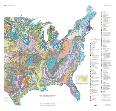
Abstract:
The surficial geologic map of the Eastern and Central United States
depicts the areal distribution of surficial geologic deposits and other
materials that accumulated or formed during the past 2+ million years,
the period that includes all activities of the human species. These
materials are at the surface of the earth. They make up the "ground"
on which we walk, the "dirt" in which we dig foundations, and the “soil”
in which we grow crops. Most of our human activity is related in one
way or another to these surface materials that are referred to
collectively by many geologists as regolith, the mantle of fragmental
and generally unconsolidated material that overlies the bedrock
foundation of the continent. The map is based on 31 published maps
in the U.S. Geological Survey's Quaternary Geologic Atlas of the
United States map series (U.S. Geological Survey Miscellaneous
Investigations Series I-1420). It was compiled at 1:1,000,000 scale,
to be viewed as a digital map at 1:2,000,000 nominal scale and to be
printed as a conventional paper map at 1:2,500,000 scale.
This map is not a map of soils as recognized and classified in
agriculture. Rather, it is a generalized map of soils as recognized
in engineering geology, or of substrata or parent materials in which
agricultural, agronomic, or pedologic soils are formed. Where surficial
deposits or materials are thick, agricultural soils are developed only
in the upper part of the engineering soils. Where they are very thin,
agricultural soils are developed through the entire thickness of a
surficial deposit or material.
The surficial geologic map provides a broad overview of the areal
distribution of surficial deposits and materials. It identifies and
depicts more than 150 types of deposits and materials. In general,
the map units are divided into two major categories, surface deposits
and residual materials. Surface deposits are materials that accumulated
or were emplaced after component particles were transported by ice,
water, wind, or gravity. The glacial sediments that cover the surface
in much of the northern United States east of the Rocky Mountains are
in this category, as are the gravel, sand, silt, and clay that were
deposited in past and present streams, lakes, and oceans. In contrast,
residual materials formed in place, without significant transport of
component particles by ice, water, wind, or gravity. They are products
of modification or alteration of pre-existing surficial deposits,
surficial materials, or bedrock. For example, intense weathering of
solid rock, or even stream deposits, by chemical processes may produce
a residual surficial material that is greatly transformed from its
original physical and chemical state.
In recent years, surficial deposits and materials have become the
focus of much interest by scientists, environmentalists, governmental
agencies, and the general public. They are the foundations of
ecosystems, the materials that support plant growth and animal
habitat, and the materials through which travels much of the water
required for our agriculture, our industry, and our general well
being. They also are materials that easily can become contaminated
by pesticides, fertilizers, and toxic wastes. In this context, the
value of the surficial geologic map is evident
The map and its digital database provide information about four
major aspects of the surficial materials, through description of
more than 150 types of materials and depiction of their areal
distribution. The map unit descriptions provide information about
(1) genesis (processes of origin) or environments of deposition
(for example, deposits related to glaciation (glacial deposits),
flowing water (alluvial deposits), lakes (lacustrine deposits),
wind (eolian deposits), or gravity (mass-movement deposits)),
(2) age (for example, how long ago the deposits accumulated or
were emplaced or how long specific processes have been acting on
the materials), (3) properties (the chemical, physical, and mechanical
or engineering characteristics of the materials), and (4) thickness
or depth to underlying deposits or materials or to bedrock. This
approach provides information appropriate for a broad user base.
The map is useful to national, state, and other governmental agencies,
to engineering and construction companies, to environmental
organizations and consultants, to academic scientists and institutions,
and to the layman who merely wishes to learn more about the materials
that conceal the bedrock. The map can facilitate regional and
national overviews of (1) geologic hazards, including areas of
swelling clay and areas of landslide deposits and landslide-prone
materials, (2) natural resources, including aggregate for concrete
and road building, peat, clay, and shallow sources for groundwater,
and (3) areas of special environmental concern, including areas of
intense erosion and areas of potential contamination of soil and
groundwater.
The map also includes lines depicting the maximum limits of glacial
advance during selected time periods.
Purpose:
This geospatial database has been prepared with a degree of detail
appropriate for viewing at a scale of 1:2,000,000. Because of the
degree of generalization required, the map is intended for regional
and national analysis, rather than for detailed analysis in specific
areas. It depicts the surficial deposits and materials at or near
the land surface, where most human interaction occurs. It does not
depict the bedrock geology, which is shown elsewhere in the National
Atlas.
Supplemental_Information:
The data set for the Surficial Deposits and Materials of the Eastern and
Central United States (East of 102 Degrees West Longitude) consists of
two layers: surficial deposits and materials, and glacial limits. The
data are available as shapefiles or Arc/Info Export files.
The data layers are distributed and should be used together. All the
data layers were created as Arc/Info coverages and converted to other
formats for distribution purposes.
The following coverages are included as ArcInfo interchange files:
ussurfm020 - Map units, as polygons, geographic projection
glacal020  - Glacial limits, as lines without line decorations, geographic projection
ussurflam  - Map units, as polygons, Lambert_Azimuthal projection
glaciallam - Glacial limits, as lines without line decorations, Lambert_Azimuthal projection
A separate package is available for shapefiles, containing
surfpoly.shp - Map units, as polygons, geographic projection
surfarc.shp  - Attributed contacts and boundaries
glacline.shp - glacial limits, as lines
Any use of trade, product, or firm names is for descriptive purposes
only and does not imply endorsement by the U.S. Government.
Although this Federal Geographic Data Committee-compliant metadata file
is intended to document the data set in nonproprietary
form, as well as in Arc/Info format, this metadata file may include
some Arc/Info-specific terminology.
Theme:
Theme_Keyword_Thesaurus: USGS Thesaurus
Theme_Keyword: geology
Theme_Keyword: geologic maps
Theme_Keyword: surficial geologic units
Theme_Keyword: geospatial datasets
Theme:
Theme_Keyword_Thesaurus:
American Geological Institute (AGI) Glossary
of Geology
Theme_Keyword: Alluvium
Theme_Keyword: Beach deposits
Theme_Keyword: Clinker
Theme_Keyword: Coastal deposits
Theme_Keyword: Colluvium
Theme_Keyword: Decomposition residuum
Theme_Keyword: Delta deposits
Theme_Keyword: Disintegration residuum
Theme_Keyword: Dune sand
Theme_Keyword: End moraine deposits
Theme_Keyword: Eolian deposits
Theme_Keyword: Estuarine deposits
Theme_Keyword: Genesis
Theme_Keyword: Geologic history
Theme_Keyword: Geologic maps
Theme_Keyword: Geologic structure
Theme_Keyword: Geology
Theme_Keyword: Glacial deposits
Theme_Keyword: Glacial limits
Theme_Keyword: Glaciofluvial deposits
Theme_Keyword: Glaciotectonic deposits
Theme_Keyword: Ground moraine deposits
Theme_Keyword: Grus
Theme_Keyword: Ice-contact deposits
Theme_Keyword: Kame Delta deposits
Theme_Keyword: Kame fan deposits
Theme_Keyword: Kame moraine deposits
Theme_Keyword: Lacustrine deposits
Theme_Keyword: Lagoon deposits
Theme_Keyword: Landslide deposits
Theme_Keyword: Loess
Theme_Keyword: Marine deposits
Theme_Keyword: Marl
Theme_Keyword: Marsh deposits
Theme_Keyword: Moraine
Theme_Keyword: Outwash deposits
Theme_Keyword: Quaternary geology
Theme_Keyword: Peat deposits
Theme_Keyword: Regional geology
Theme_Keyword: Residuum
Theme_Keyword: Sand deposits
Theme_Keyword: Saprolite
Theme_Keyword: Sedimentary rocks
Theme_Keyword: Sheet sand
Theme_Keyword: Sheetwash alluvium
Theme_Keyword: Slackwater deposits
Theme_Keyword: Solifluction deposits
Theme_Keyword: Stagnation moraine deposits
Theme_Keyword: Surficial deposits
Theme_Keyword: Surficial geologic units
Theme_Keyword: Swamp deposits
Theme_Keyword: Till
Theme_Keyword: unconsolidated deposits
Theme:
Theme_Keyword_Thesaurus: ISO 19115 Topic Categories
Theme_Keyword: geoscientificInformation
Place:
Place_Keyword_Thesaurus: U.S. Board on Geographic Names (BGN)
Place_Keyword: Allegheny Plateau
Place_Keyword: Appalachian Plateau
Place_Keyword: Atlantic Coastal Plain
Place_Keyword: Central United States
Place_Keyword: Eastern United States
Place_Keyword: Great Lakes region
Place_Keyword: Great Plains
Place_Keyword: Gulf Coastal plain
Place_Keyword: Mississippi embayment
Place_Keyword: New England
Place_Keyword: Ouachita mountains
Place_Keyword: Ridge-and-Valley province
Place_Keyword: Alabama
Place_Keyword: Arkansas
Place_Keyword: Connecticut
Place_Keyword: Delaware
Place_Keyword: Florida
Place_Keyword: Georgia
Place_Keyword: Illinois
Place_Keyword: Indiana
Place_Keyword: Iowa
Place_Keyword: Kansas
Place_Keyword: Kentucky
Place_Keyword: Louisiana
Place_Keyword: Maine
Place_Keyword: Maryland
Place_Keyword: Massachusetts
Place_Keyword: Michigan
Place_Keyword: Minnesota
Place_Keyword: Mississippi
Place_Keyword: Missouri
Place_Keyword: Nebraska
Place_Keyword: New Hampshire
Place_Keyword: New Jersey
Place_Keyword: New York
Place_Keyword: North Carolina
Place_Keyword: North Dakota
Place_Keyword: Ohio
Place_Keyword: Oklahoma
Place_Keyword: Pennsylvania
Place_Keyword: Rhode Island
Place_Keyword: South Carolina
Place_Keyword: South Dakota
Place_Keyword: Tennessee
Place_Keyword: Texas
Place_Keyword: Vermont
Place_Keyword: Virginia
Place_Keyword: West Virginia
Place_Keyword: Wisconsin
Place_Keyword: Austin quadrangle
Place_Keyword: Blue Ridge quadrangle
Place_Keyword: Boston quadrangle
Place_Keyword: Chesapeake Bay quadrangle
Place_Keyword: Chicago quadrangle
Place_Keyword: Dakotas quadrangle
Place_Keyword: Dallas quadrangle
Place_Keyword: Des Moines quadrangle
Place_Keyword: Florida Keys quadrangle
Place_Keyword: Hatteras quadrangle
Place_Keyword: Hudson River quadrangle
Place_Keyword: Jacksonville quadrangle
Place_Keyword: Lake Erie quadrangle
Place_Keyword: Lake Nipigon quadrangle
Place_Keyword: Lake of the Woods quadrangle
Place_Keyword: Lake Superior quadrangle
Place_Keyword: Lookout Mountain quadrangle
Place_Keyword: Louisville quadrangle
Place_Keyword: Minneapolis quadrangle
Place_Keyword: Mobile quadrangle
Place_Keyword: Monterrey quadrangle
Place_Keyword: Ottawa quadrangle
Place_Keyword: Ozark Plateau quadrangle
Place_Keyword: Platte River quadrangle
Place_Keyword: Quebec quadrangle
Place_Keyword: Savannah quadrangle
Place_Keyword: Sudbury quadrangle
Place_Keyword: Vicksburg quadrangle
Place_Keyword: White Lake quadrangle
Place_Keyword: Wichita quadrangle
Place_Keyword: Winnipeg quadrangle
Place:
Place_Keyword_Thesaurus: Augmented FIPS 10-4 and FIPS 6-4
Place_Keyword: US01 = Alabama
Place_Keyword: US05 = Arkansas
Place_Keyword: US09 = Connecticut
Place_Keyword: US10 = Delaware
Place_Keyword: US11 = District of Columbia
Place_Keyword: US12 = Florida
Place_Keyword: US13 = Georgia
Place_Keyword: US17 = Illinois
Place_Keyword: US18 = Indiana
Place_Keyword: US19 = Iowa
Place_Keyword: US21 = Kentucky
Place_Keyword: US22 = Louisiana
Place_Keyword: US23 = Maine
Place_Keyword: US24 = Maryland
Place_Keyword: US25 = Massachusetts
Place_Keyword: US26 = Michigan
Place_Keyword: US27 = Minnesota
Place_Keyword: US28 = Mississippi
Place_Keyword: US29 = Missouri
Place_Keyword: US33 = New Hampshire
Place_Keyword: US34 = New Jersey
Place_Keyword: US36 = New York
Place_Keyword: US37 = North Carolina
Place_Keyword: US39 = Ohio
Place_Keyword: US40 = Oklahoma
Place_Keyword: US42 = Pennsylvania
Place_Keyword: US44 = Rhode Island
Place_Keyword: US45 = South Carolina
Place_Keyword: US47 = Tennessee
Place_Keyword: US48 = Texas
Place_Keyword: US50 = Vermont
Place_Keyword: US51 = Virginia
Place_Keyword: US54 = West Virginia
Place_Keyword: US55 = Wisconsin
Place_Keyword: US38 = North Dakota
Place_Keyword: US46 = South Dakota
Place_Keyword: US31 = Nebraska
Place_Keyword: US20 = Kansas
Temporal:
Temporal_Keyword_Thesaurus:
American Geological Institute (AGI)
Glossary of Geology
Temporal_Keyword: Holocene
Temporal_Keyword: Illinoian
Temporal_Keyword: Late Wisconsin
Temporal_Keyword: Pleistocene
Temporal_Keyword: Pre-Illinoian
Temporal_Keyword: Quaternary
Temporal_Keyword: Sangamon
Temporal_Keyword: Tertiary
Temporal_Keyword: Wisconsin
None. Acknowledgment of the U.S. Geological Survey will be
appreciated in products derived from these data.
Geologic compilation by David S. Fullerton; digitization by
Charles A. Bush and Jean N. Pennell; digital cartography by
Diane Lane, Nancy Shock, and William Sowers.
The files are stored in the UNIX version of
Arc/Info version 7.1.1.