Surficial deposits and materials in the eastern and central United States (east of 102 degrees west longitude)

Metadata also available as - [Outline] - [Parseable text] - [XML]

Frequently anticipated questions:


What does this data set describe?

Title:
Surficial deposits and materials in the eastern and central United States (east of 102 degrees west longitude)
Abstract:
The surficial geologic map of the Eastern and Central United States depicts the areal distribution of surficial geologic deposits and other materials that accumulated or formed during the past 2+ million years, the period that includes all activities of the human species. These materials are at the surface of the earth. They make up the "ground" on which we walk, the "dirt" in which we dig foundations, and the “soil” in which we grow crops. Most of our human activity is related in one way or another to these surface materials that are referred to collectively by many geologists as regolith, the mantle of fragmental and generally unconsolidated material that overlies the bedrock foundation of the continent. The map is based on 31 published maps in the U.S. Geological Survey's Quaternary Geologic Atlas of the United States map series (U.S. Geological Survey Miscellaneous Investigations Series I-1420). It was compiled at 1:1,000,000 scale, to be viewed as a digital map at 1:2,000,000 nominal scale and to be printed as a conventional paper map at 1:2,500,000 scale.
This map is not a map of soils as recognized and classified in agriculture. Rather, it is a generalized map of soils as recognized in engineering geology, or of substrata or parent materials in which agricultural, agronomic, or pedologic soils are formed. Where surficial deposits or materials are thick, agricultural soils are developed only in the upper part of the engineering soils. Where they are very thin, agricultural soils are developed through the entire thickness of a surficial deposit or material.
The surficial geologic map provides a broad overview of the areal distribution of surficial deposits and materials. It identifies and depicts more than 150 types of deposits and materials. In general, the map units are divided into two major categories, surface deposits and residual materials. Surface deposits are materials that accumulated or were emplaced after component particles were transported by ice, water, wind, or gravity. The glacial sediments that cover the surface in much of the northern United States east of the Rocky Mountains are in this category, as are the gravel, sand, silt, and clay that were deposited in past and present streams, lakes, and oceans. In contrast, residual materials formed in place, without significant transport of component particles by ice, water, wind, or gravity. They are products of modification or alteration of pre-existing surficial deposits, surficial materials, or bedrock. For example, intense weathering of solid rock, or even stream deposits, by chemical processes may produce a residual surficial material that is greatly transformed from its original physical and chemical state.
In recent years, surficial deposits and materials have become the focus of much interest by scientists, environmentalists, governmental agencies, and the general public. They are the foundations of ecosystems, the materials that support plant growth and animal habitat, and the materials through which travels much of the water required for our agriculture, our industry, and our general well being. They also are materials that easily can become contaminated by pesticides, fertilizers, and toxic wastes. In this context, the value of the surficial geologic map is evident
The map and its digital database provide information about four major aspects of the surficial materials, through description of more than 150 types of materials and depiction of their areal distribution. The map unit descriptions provide information about (1) genesis (processes of origin) or environments of deposition (for example, deposits related to glaciation (glacial deposits), flowing water (alluvial deposits), lakes (lacustrine deposits), wind (eolian deposits), or gravity (mass-movement deposits)), (2) age (for example, how long ago the deposits accumulated or were emplaced or how long specific processes have been acting on the materials), (3) properties (the chemical, physical, and mechanical or engineering characteristics of the materials), and (4) thickness or depth to underlying deposits or materials or to bedrock. This approach provides information appropriate for a broad user base. The map is useful to national, state, and other governmental agencies, to engineering and construction companies, to environmental organizations and consultants, to academic scientists and institutions, and to the layman who merely wishes to learn more about the materials that conceal the bedrock. The map can facilitate regional and national overviews of (1) geologic hazards, including areas of swelling clay and areas of landslide deposits and landslide-prone materials, (2) natural resources, including aggregate for concrete and road building, peat, clay, and shallow sources for groundwater, and (3) areas of special environmental concern, including areas of intense erosion and areas of potential contamination of soil and groundwater.
The map also includes lines depicting the maximum limits of glacial advance during selected time periods.
Supplemental_Information:
The data set for the Surficial Deposits and Materials of the Eastern and Central United States (East of 102 Degrees West Longitude) consists of two layers: surficial deposits and materials, and glacial limits. The data are available as shapefiles or Arc/Info Export files. The data layers are distributed and should be used together. All the data layers were created as Arc/Info coverages and converted to other formats for distribution purposes.
The following coverages are included as ArcInfo interchange files:
ussurfm020 - Map units, as polygons, geographic projection
glacal020  - Glacial limits, as lines without line decorations, geographic projection
ussurflam  - Map units, as polygons, Lambert_Azimuthal projection
glaciallam - Glacial limits, as lines without line decorations, Lambert_Azimuthal projection
A separate package is available for shapefiles, containing
surfpoly.shp - Map units, as polygons, geographic projection
surfarc.shp  - Attributed contacts and boundaries
glacline.shp - glacial limits, as lines
Any use of trade, product, or firm names is for descriptive purposes only and does not imply endorsement by the U.S. Government.
Although this Federal Geographic Data Committee-compliant metadata file is intended to document the data set in nonproprietary form, as well as in Arc/Info format, this metadata file may include some Arc/Info-specific terminology.
  1. How might this data set be cited?
    Fullerton, David S., Bush, Charles A., and Pennell, Jean N., 2003, Surficial deposits and materials in the eastern and central United States (east of 102 degrees west longitude): U.S. Geological Survey Geologic Investigations Series I-2789, U.S. Geological Survey, Denver, CO.

    Online Links:

  2. What geographic area does the data set cover?
    West_Bounding_Coordinate: -102.000
    East_Bounding_Coordinate: -66.955
    North_Bounding_Coordinate: 49.386
    South_Bounding_Coordinate: 24.518
  3. What does it look like?
    http://pubs.usgs.gov/imap/i-2789/i-2789.gif (GIF)
    Reduced-size image of the entire map sheet, 400x383 pixels, 87k bytes
    http://pubs.usgs.gov/imap/i-2789/i-2789.pdf (PDF)
    A screen-optimized version of the printed map (62MB), including limits of glaciation at 1:2,500,000 scale. Details of this map may be enlarged on screen. Although the digital data are provided in geographic projection and in Lambert_Azimuthal projection, this graphic is from a map in Lambert Azimuthal projection with the following parameters: Radius of the sphere of reference, 6370997; Longitude of center of projection, -100; and latitude of center of projection, 45.
    http://pubs.usgs.gov/imap/i-2789/i-2789_bg.pdf (PDF)
    A low-resolution (3.8 MB) rasterized version of the printed map, including limits of glaciation at 1:2,500,000 scale. This map is best viewed at 75% of actual size Although the digital data are provided in geographic projection and in Lambert_Azimuthal projection, this graphic is from a map in Lambert Azimuthal projection with the following parameters: Radius of the sphere of reference, 6370997; Longitude of center of projection, -100; and latitude of center of projection, 45.
  4. Does the data set describe conditions during a particular time period?
    Beginning_Date: 01-Mar-1998
    Ending_Date: 01-Jun-2000
    Currentness_Reference:
    The data were compiled and digitized during the above dates.
  5. What is the general form of this data set?
    Geospatial_Data_Presentation_Form: map
  6. How does the data set represent geographic features?
    1. How are geographic features stored in the data set?
      This is a Vector data set. It contains the following vector data types (SDTS terminology):
      • Point (20702)
      • String (64909)
      • GT-polygon composed of chains (20702)
    2. What coordinate system is used to represent geographic features?
      Horizontal positions are specified in geographic coordinates, that is, latitude and longitude. Latitudes are given to the nearest 0.002. Longitudes are given to the nearest 0.002. Latitude and longitude values are specified in Decimal degrees. The horizontal datum used is North American Datum of 1983.
      The ellipsoid used is GRS1980.
      The semi-major axis of the ellipsoid used is 6378206.4.
      The flattening of the ellipsoid used is 1/294.98.
  7. How does the data set describe geographic features?
    Geologic unit (described by ussurfm020.pat or surfpoly.shp)
    The map is a surficial materials map. Deposits and residual materials are distinguished in part on the basis of particle size or texture, particle lithology or composition, and other physical, chemical, and engineering characteristics. It is not a map of soils that are recognized in agriculture, agronomy, or pedology. Rather, it is a generalized map of soils as recognized in engineering geology, or of substrata or parent materials in which agricultural soils are formed. Several classification systems for engineering and agricultural soils are in use, and terminology differs. The textural or particle size divisions (e.g., clay, sand, pebbles, boulders) and the matrix nomenclature (e.g., loamy sand, clay loam, silty clay) of the U.S. Department of Agriculture are used here to ensure uniformity of terminology. (Source: U.S. Geological Survey)
    Geounit
    Two digit letter symbol for the map unit description (Source: U.S. Geological Survey)
    ValueDefinition
    tcGround-moraine deposits (Clayey till of late Wisconsin and Holocene(?) age)
    tdEnd-moraine deposits (Clayey till of late Wisconsin and Holocene(?) age)
    tlGround-moraine deposits (Loamy till of late Wisconsin and Holocene(?) age)
    tmEnd-moraine deposits (Loamy till of late Wisconsin and Holocene(?) age)
    tnStagnation-moraine deposits (Loamy till of late Wisconsin and Holocene(?) age)
    toFlood-scoured till (Loamy till of late Wisconsin and Holocene(?) age)
    tsGround-moraine deposits (Sandy till of late Wisconsin and Holocene(?) age)
    ttEnd-moraine deposits (Sandy till of late Wisconsin and Holocene(?) age)
    txClayey to sandy till (of late Wisconsin and Holocene(?) age)
    (tq)Collapsed till and glacial-lake deposits (of late Wisconsin and Holocene(?) age)
    (tg)Till, ice-contact deposits, glaciofluvial deposits, and glaciolacustrine deposits of late Wisconsin and Illinoian age
    taClayey to loamy till of Illinoian age
    tkGround-moraine deposits (Loamy till of Illinoian age)
    tjEnd-moraine deposits (Loamy till of Illinoian age)
    tfLoamy till of Illinoian and pre-Illinoian age
    tpClayey to loamy till of pre-Illinoian age
    thClayey to sandy till of pre-Illinoian age
    tbLoamy till of pre-Illinoian age
    (tr)Pre-Illinoian age discontinuous till, discontinuous glaciofluvial deposits, and concentrations of erratic boulders and cobbles
    faSurficial deposits, surficial materials, and bedrock masses that were deformed and (or) transported intact by glacial ice
    (lk)Beach sand and dune sand of Holocene age (in beaches, spits, and barriers)
    lcClay and silt (Glacial and postglacial lake deposits of Holocene and late Wisconsin age)
    lfSilt and sand (Glacial and postglacial lake deposits of Holocene and late Wisconsin age)
    lsSand and gravel (Glacial and postglacial lake deposits of Holocene and late Wisconsin age)
    luClay, silt, sand, and gravel (Glacial and postglacial lake deposits of Holocene and late Wisconsin age)
    lhDensity-current underflow-fan deposits (Glacial and postglacial lake deposits of Holocene and late Wisconsin age)
    ldDelta deposits (Glacial and postglacial lake deposits of Holocene and late Wisconsin age)
    (lo)Slack-water lake deposits and alluvium of late Wisconsin age
    laGlacial-lake clay and silt (Lake deposits of Illinoian age)
    (ln)Slack-water lake deposits and alluvium (Lake deposits of Illinoian age)
    lbGlacial-lake clay and silt (Lake deposits of pre-Illinoian age)
    (lp)Slack-water lake deposits and alluvium (Lake deposits of pre-Illinoian age)
    lmMarl of Holocene and late and middle Wisconsin(?) age
    lgPluvial clay, silt, sand, and dolomite of late Pleistocene age
    hpPeat and muck (Inland deposits of Holocene and late Wisconsin age)
    hsFresh-water swamp deposits (Inland deposits of Holocene and late Wisconsin age)
    hbFresh-water coastal-marsh peat and clay (Coastal deposits of Holocene age)
    (hd)Swamp deposits and dune sand (Coastal deposits of Holocene age)
    haMangrove-swamp deposits (Coastal deposits of Holocene age)
    heAlgal-mat and carbonate deposits (Coastal deposits of Holocene age)
    hcFresh-water, brackish-water, and (or) saline-marsh deposits of Holocene and late Wisconsin age
    mcClay and silt (Glaciomarine deposits of late Wisconsin age)
    meSand and gravel (Glaciomarine deposits of late Wisconsin age)
    mdDelta deposits (Glaciomarine deposits of late Wisconsin age)
    (mt)Glaciomarine deposits and till (Glaciomarine deposits of late Wisconsin age)
    bbQuartz beach sand (Beach deposits of Holocene age (in beaches, spits, tombolos, hooks, and barriers))
    baBeach shell-fragment and shell (Beach deposits of Holocene age (in beaches, spits, tombolos, hooks, and barriers))
    bmBeach mud (Beach deposits of Holocene age (in beaches, spits, tombolos, hooks, and barriers))
    (bd)Beach sand and dune sand (Beach deposits of Holocene age (in beaches, spits, tombolos, hooks, and barriers))
    (bc)Beach sand, dune sand, and delta deposits of Holocene and late Pleistocene age
    mkBack-island-slope, wash-over-channel, lagoon, and wind-tidal-flat deposits (Coastal-plain marine deposits of Holocene age)
    (db)Delta deposits (Coastal-plain marine deposits of Holocene age)
    moOolitic limestone (Coastal-plain marine deposits of late and middle Pleistocene age)
    mlCoralline limestone (Coastal-plain marine deposits of late and middle Pleistocene age)
    (mm)Coastal-plain marine deposits (lagoon and beach deposits) of Pleistocene age
    mbBeach and near-shore deposits (Coastal-plain marine deposits of Pleistocene and Pliocene age)
    maBack-barrier and lagoon deposits (Coastal-plain marine deposits of Pleistocene and Pliocene age)
    msSand (Coastal-plain marine deposits of Pleistocene and Pliocene age)
    (da)Delta deposits (Coastal-plain marine deposits of Pleistocene and Pliocene age)
    (mh)Coastal-plain marine deposits of early Pleistocene and Pliocene age
    ee"Clay dune" deposits of Holocene age
    elLoess of Holocene and late Wisconsin age
    ebLoess of Holocene and late and middle Pleistocene age
    (ea)Loess, loessal alluvium, and loessal colluvium of late and middle Pleistocene age
    euSand and silt of Holocene and late Wisconsin age
    edDune sand (Sand of Holocene and late Pleistocene age)
    esSheet sand (Sand of Holocene and late Pleistocene age)
    (ec)Sheet sand, loess, loessal alluvium, and loessal colluvium of Holocene and Pleistocene age
    ksIce-contact silt and sand (Ice-contact deposits of late Wisconsin and Holocene(?) age)
    kgIce-contact sand and gravel (Ice-contact deposits of late Wisconsin and Holocene(?) age)
    keKame end-moraine or kame interlobate-moraine deposits (Ice-contact deposits of late Wisconsin and Holocene(?) age)
    (kf)Subaerial and subaqueous kame-fan deposits (Ice-contact deposits of late Wisconsin and Holocene(?) age)
    (kd)Glaciolacustrine kame-delta deposits (Ice-contact deposits of late Wisconsin and Holocene(?) age)
    (km)Marine kame-delta deposits (Ice-contact deposits of late Wisconsin and Holocene(?) age)
    (kt)Ice-contact deposits and till (Ice-contact deposits of late Wisconsin and Holocene(?) age)
    (kl)Ice-contact deposits and glacial-lake deposits (Ice-contact deposits of late Wisconsin and Holocene(?) age)
    kaIce-contact sand and gravel of Illinoian age
    gsOutwash sand (Glaciofluvial (outwash) deposits of late Wisconsin and Holocene(?) age)
    ggOutwash sand and gravel (Glaciofluvial (outwash) deposits of late Wisconsin and Holocene(?) age)
    (gt)Outwash deposits and till (Glaciofluvial (outwash) deposits of late Wisconsin and Holocene(?) age)
    (gl)Outwash deposits and ice-contact deposits (Glaciofluvial (outwash) deposits of late Wisconsin and Holocene(?) age)
    (gk)Outwash deposits, ice-contact deposits, and glacial-lake deposits (Glaciofluvial (outwash) deposits of late Wisconsin and Holocene(?) age)
    gaOutwash silt, sand, and gravel (Glaciofluvial (outwash) deposits of Illinoian age)
    (gd)Outwash silt, outwash sand, and alluvium (Glaciofluvial (outwash) deposits of Illinoian age)
    gbOutwash sand and gravel (Glaciofluvial (outwash) deposits of pre-Illinoian age)
    (gc)Outwash sand and gravel and till (Glaciofluvial (outwash) deposits of pre-Illinoian age)
    ahFlood deposits (Catastrophic glacial outburst-flood deposits of late Wisconsin age)
    (ak)Flood deposits and flood-scoured till (Catastrophic glacial outburst-flood deposits of late Wisconsin age)
    (ag)Alluvial, outwash, ice-contact, and glacial-lake deposits of Holocene and late Wisconsin age
    (ab)Alluvial outwash, ice-contact, and glacial-lake deposits of middle Pleistocene age
    alChannel and flood-plain alluvium of Holocene and late Wisconsin age
    (ai)Alluvial deposits, lake deposits, and eolian deposits of Holocene and late and middle Pleistocene age
    anChannel and flood-plain alluvium of Holocene and Pleistocene age
    (ae)Alluvial deposits and estuarine marine deposits of Holocene, Pleistocene, and Pliocene age
    (ao)Cemented channel and flood-plain alluvium, fan alluvium, sheetwash alluvium, and pediment(?) alluvium (Channel and flood-plain alluvium of Holocene, Pleistocene, and Pliocene age)
    apAlluvial delta deposits (Channel and flood-plain alluvium of Holocene, Pleistocene, and Pliocene age)
    atAlluvium of Pleistocene age beneath terraces, in paleovalleys, and on upland surfaces
    acArkosic alluvium of middle and early Pleistocene and Pliocene age
    aaCemented alluvium (Channel and flood-plain alluvium of early Pleistocene and Pliocene age)
    (aj)Alluvial deposits and lake deposits (Channel and flood-plain alluvium of early Pleistocene and Pliocene age)
    (af)Alluvial-fan and sheetwash-fan deposits of Holocene and late and middle Pleistocene age
    wbSheetwash alluvium (Sheetwash alluvium of Holocene and late Wisconsin age)
    waSheetwash alluvium in badland terrain (Sheetwash alluvium of Holocene and late Wisconsin age)
    (wc)Sheetwash alluvium and lake deposits (Sheetwash alluvium of Holocene and late Wisconsin age)
    jaSlump-block, earthflow, and mudflow deposits of Holocene age
    (jc)Landslide deposits, bouldery colluvium, and sheetwash alluvium (Landslide deposits of Holocene and late Wisconsin age)
    (jb)Landslide deposits, disintegration residuum, and sheetwash alluvium (Landslide deposits of Holocene and late Wisconsin age)
    (na)Loamy solifluction deposits, colluvium, and decomposition residuum of Holocene and late and middle Pleistocene age
    (nb)Loamy solifluction deposits of late Wisconsin age
    (cp)Colluvium, sheetwash alluvium, and landslide deposits of Holocene and late Wisconsin age
    cjClayey chert-clast colluvium (Colluvium of Holocene and late Pleistocene age)
    cgGravelly colluvium (Colluvium of Holocene and late Pleistocene age)
    cdCrystalline-boulder colluvium (Colluvium of Holocene and late and middle Pleistocene age)
    ceDiabase- and basalt-clast colluvium (Colluvium of Holocene and late and middle Pleistocene age)
    cbResistant-block or resistant-boulder colluvium and rock waste (Colluvium of Holocene and late and middle Pleistocene age)
    cqSandstone-block or sandstone-boulder colluvium (Colluvium of Holocene and late and middle Pleistocene age)
    ccCarbonate-boulder or carbonate-clast colluvium (Colluvium of Holocene and late and middle Pleistocene age)
    clClastic-clast colluvium (Colluvium of Holocene and late and middle Pleistocene age)
    (cv)Locally gypsiferous, clastic-clast colluvium and solution residuum (Colluvium of Holocene and late and middle Pleistocene age)
    cfAcid shale-chip colluvium (Colluvium of Holocene and late and middle Pleistocene age)
    csCalcareous shale-chip and siltstone-clast colluvium (Colluvium of Holocene and late and middle Pleistocene age)
    coShale-clast, chalk-clast, and chalky limestone-clast colluvium (Colluvium of Holocene and late and middle Pleistocene age)
    ciCalcrete-clast colluvium (Colluvium of Holocene and late and middle Pleistocene age)
    ckChert-clast colluvium (Colluvium of Holocene and late and middle Pleistocene age)
    chSandy to clayey colluvium (Colluvium of Holocene and late and middle Pleistocene age)
    cuColluvium complex (Colluvium of Holocene and late and middle Pleistocene age)
    (cx)Colluvium and loess (Colluvium of Holocene and late and middle Pleistocene age)
    (cr)Colluvium and solution residuum (Colluvium of Holocene and late and middle Pleistocene age)
    (cm)Colluvium, decomposition residuum, and solution residuum (Colluvium of Holocene and late and middle Pleistocene age)
    (ca)Colluvium and sheetwash alluvium (Colluvium of Quaternary age)
    (cz)Colluvium, decomposition residuum, and solution residuum (Colluvium of Quaternary age)
    (cw)Colluvium and decomposition residuum of Quaternary and Tertiary age
    (ct)Colluvium and alluvium of Pleistocene age
    uaGlaciated granitic grus (Grus of Quaternary and Tertiary age)
    ubFeldspathic sandy grus (Grus of Quaternary and Tertiary age)
    (xm)Smectitic disintegration residuum and sheetwash alluvium on bentonitic shale, micaceous shale, and soft clayey shale (Disintegration residuum of Holocene and late Wisconsin age)
    (xh)Silty clay loam disintegration residuum and sheetwash alluvium (Disintegration residuum of Holocene and late Wisconsin age)
    (xi)Loamy disintegration residuum and sheetwash alluvium on clayey shale (Disintegration residuum of Holocene and late Wisconsin age)
    (xk)Loamy disintegration residuum, sheetwash alluvium, and colluvium on sandstone, siltstone, and shale (Disintegration residuum of Holocene and late Wisconsin age)
    (xl)Loamy disintegration residuum, sheetwash alluvium, and colluvium on sandstone, siltstone, mudstone, claystone,shale, and lignite (Disintegration residuum of Holocene and late Wisconsin age)
    (xj)Sandy disintegration residuum, sheetwash alluvium, and colluvium on soft sandstone, siltstone, and shale (Disintegration residuum of Holocene and late Wisconsin age)
    xgCemented, gravelly disintegration residuum (Disintegration residuum of Holocene and late and middle Pleistocene age)
    xcQuartz sand disintegration residuum (Disintegration residuum of Holocene and late and middle Pleistocene age)
    xaDisintegration residuum on clastic rocks (Disintegration residuum of Holocene and late and middle Pleistocene age)
    xbDisintegration residuum on clastic rocks and carbonate rocks (Disintegration residuum of Holocene and late and middle Pleistocene age)
    xdStony, gypsiferous disintegration residuum (Disintegration residuum of Holocene and late and middle Pleistocene age)
    (xe)Silty clay disintegration residuum and gypsiferous solution residuum (Disintegration residuum of Holocene and late and middle Pleistocene age)
    (zx)Decomposition residuum and colluvium of Holocene and late and Middle Pleistocene age on igneous and metamorphic rocks
    zbDecomposition residuum on sand and gravel beneath high stream terraces and in alluvial fans (Decomposition residuum of Quaternary and Tertiary age on sand and gravel)
    zkDecomposition residuum on upland sand and gravel and on paleochannel fill deposits (Decomposition residuum of Quaternary and Tertiary age on sand and gravel)
    znChert-pebble decomposition residuum on channel gravel and sand (Decomposition residuum of Quaternary and Tertiary age on sand and gravel)
    zgCrumbly quartz-clast decomposition residuum on sand and gravel (Decomposition residuum of Quaternary and Tertiary age on sand and gravel)
    zcDecomposition residuum on sand or mixed-composition sand and gravel on upland surfaces (Decomposition residuum of Quaternary and Tertiary age on sand and gravel)
    zlQuartz-pebble, chert-pebble, and quartzite-pebble decomposition residuum on sand and gravel on upland surfaces (Decomposition residuum of Quaternary and Tertiary age on sand and gravel)
    zeSmectitic-clay decomposition residuum (Decomposition residuum of Quaternary age on sedimentary rocks that contain swelling-clay minerals or that weather to form swelling-clay minerals)
    zpSand, silt, and smectitic-clay decomposition residuum (Decomposition residuum of Quaternary age on sedimentary rocks that contain swelling-clay minerals or that weather to form swelling-clay minerals)
    zuGravel, sand, silt, and smectitic-clay decomposition residuum (Decomposition residuum of Quaternary age on sedimentary rocks that contain swelling-clay minerals or that weather to form swelling-clay minerals)
    zjDecomposition residuum complex (Decomposition residuum of Quaternary age on sedimentary rocks that contain swelling-clay minerals or that weather to form swelling-clay minerals)
    zvDecomposition residuum complex (Decomposition residuum of Quaternary age on sedimentary rocks that contain swelling-clay minerals or that weather to form swelling-clay minerals)
    zaClayey to sandy decomposition residuum (Decomposition residuum of Quaternary and Tertiary age on other sedimentary rocks)
    zfFerruginous sand and clay decomposition residuum (Decomposition residuum of Quaternary and Tertiary age on other sedimentary rocks)
    (zd)Decomposition residuum and colluvium on shale, siltstone,and sandstone (Decomposition residuum of Quaternary and Tertiary age on other sedimentary rocks)
    zsDecomposition residuum on sandstone, siltstone, shale, limestone,and dolomite (Decomposition residuum of Quaternary and Tertiary age on other sedimentary rocks)
    (zt)Decomposition residuum and colluvium on arkose, sandstone,argillite, shale, and conglomerate (Decomposition residuum of Quaternary and Tertiary age on other sedimentary rocks)
    (zo)Clayey to sandy decomposition residuum and solution residuum (Decomposition residuum of Quaternary and Tertiary age on other sedimentary rocks)
    (zh)Cherty decomposition residuum, solution residuum, and colluvium on limestone, shale, and sandstone (Decomposition residuum of Quaternary and Tertiary age on other sedimentary rocks)
    (zi)Clayey to sandy decomposition residuum and solution residuum on sandstone, quartzite, shale, dolomite, and cherty limestone (Decomposition residuum of Quaternary and Tertiary age on other sedimentary rocks)
    (zr)Clayey to sandy decomposition residuum and solution residuum on clay, shale, coal, sandstone, and limestone (Decomposition residuum of Quaternary and Tertiary age on other sedimentary rocks)
    (zm)Loamy decomposition residuum and colluvium on sedimentary rocks of mixed compositions (Decomposition residuum of Quaternary and Tertiary age on other sedimentary rocks)
    rcChert-poor or chert-free, clayey to sandy solution residuum (Solution residuum of Quaternary and Tertiary age)
    raCherty, clayey to sandy solution residuum (Solution residuum of Quaternary and Tertiary age)
    rbSolution residuum complex (Solution residuum of Quaternary and Tertiary age)
    rdCherty, quartz-sand solution residuum (Solution residuum of Quaternary and Tertiary age)
    reSandy solution residuum (Solution residuum of Quaternary and Tertiary age)
    (rg)Plastic-clay solution residuum and cherty colluvium (Solution residuum of Quaternary and Tertiary age)
    (rh)Solution residuum and decomposition residuum (Solution residuum of Quaternary and Tertiary age)
    sgClayey to sandy saprolitized sand and gravel of Quaternary and Tertiary age
    saClayey to sandy saprolite on granite, gneiss, schist, and other felsic, mafic, and ultramafic igneous and metamorphic rocks (Saprolite of Quaternary and Tertiary age on crystalline igneous and metamorphic rocks)
    sbMicaceous saprolite on felsic micaceous schist or rocks of mixed composition (Saprolite of Quaternary and Tertiary age on crystalline igneous and metamorphic rocks)
    seClayey saprolite on diabase and basalt (Saprolite of Quaternary and Tertiary age on crystalline igneous and metamorphic rocks)
    sfClayey saprolite on nephelene syenite (Saprolite of Quaternary and Tertiary age on crystalline igneous and metamorphic rocks)
    scClayey to sandy saprolite on phyllite, argillite, slate, marble,greenstone, serpentinite, metabasalt, metarhyolite, and other felsic metavolcanic rocks (Saprolite of Quaternary and Tertiary age on crystalline igneous and metamorphic rocks)
    sdQuartz-rich saprolite of Quaternary and Tertiary age
    (qa)Clinker and colluvium
    fMan-made land
    waterwater body (lake or large river)
    Color
    The shade pattern number from the Arc/Info shadeset color524.shd. (Source: U.S. Geological Survey)
    Range of values
    Minimum:0
    Maximum:524
    R
    Percentage of red used to produce map unit colors. (Source: U.S. Geological Survey)
    Range of values
    Minimum:0
    Maximum:255
    G
    Percentage of green used to produce map unit colors. (Source: U.S. Geological Survey)
    Range of values
    Minimum:0
    Maximum:255
    B
    Percentage of blue used to produce map unit colors. (Source: U.S. Geological Survey)
    Range of values
    Minimum:0
    Maximum:255
    Rock or geologic deposit boundary line (described by ussurfm020.aat or surfarcs.shp)
    Line separating different geologic units. (Source: U.S. Geological Survey)
    Ltype
    The type of geologic boundary code. (Source: U.S. Geological Survey)
    ValueDefinition
    BorderBoundary where the map unit is terminated at the international border with Canada
    ClosureAn imaginary line defining the western edge of the map
    ContactA line where two different map units meet
    RiverbankA line defining either side of a river
    ShorelineA line where map units are terminated at bodies of water
    StreamLine where map units are terminated by the Rio Grande, which forms the boundary with Mexico
    Glacial limit line, without line decorations (described by glacal020.aat or glacal.shp)
    A line showing the southern limit of glaciation in the United States at various times. (Source: U.S. Geological Survey)
    Ltype
    The lines of the glacial limits were compiled with the surficial polygons. Only one item, ltype, was used. The item value indicates the geologic time period associated with each position of maximum glacial advance. (Source: U.S. Geological Survey)
    ValueDefinition
    illThe southern limit of glaciation during Illinoian time, 310,000-128,000 yr ago.
    ill infThe southern limit of glaciation during Illinoian time, 310,000-128,000 yr ago, inferred.
    ill or preillThe southern limit of glaciation during Illinoian or pre-Illinoian time, earlier than 128,000 yr ago.
    late wiscThe southern limit of glaciation during Late Wisconsin time, 35,000 - 11,150 yr ago.
    late wisc infThe southern limit of glaciation during Late Wisconsin time, 35,000 - 11,150 yr ago, inferred.
    preillThe southern limit of glaciation prior to Illinoian time, earlier than 310,000 yr ago.
    preill infThe southern limit of glaciation prior to Illinoian time, earlier than 310,000 yr ago, inferred.

Who produced the data set?

  1. Who are the originators of the data set? (may include formal authors, digital compilers, and editors)
    • David S. Fullerton
    • Charles A. Bush
    • Jean N. Pennell
  2. Who also contributed to the data set?
    Geologic compilation by David S. Fullerton; digitization by Charles A. Bush and Jean N. Pennell; digital cartography by Diane Lane, Nancy Shock, and William Sowers.
  3. To whom should users address questions about the data?
    David S. Fullerton
    U.S. Geological Survey
    Research Geologist
    Mail Stop 913, Box 25046
    Lakewood, CO
    USA

    (303) 236-1232 (voice)
    (303) 236-0214 (FAX)
    fullerton@usgs.gov

Why was the data set created?

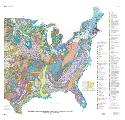
This geospatial database has been prepared with a degree of detail appropriate for viewing at a scale of 1:2,000,000. Because of the degree of generalization required, the map is intended for regional and national analysis, rather than for detailed analysis in specific areas. It depicts the surficial deposits and materials at or near the land surface, where most human interaction occurs. It does not depict the bedrock geology, which is shown elsewhere in the National Atlas.

How was the data set created?

  1. From what previous works were the data drawn?
    NH-14 (source 1 of 31)
    David W. Moore (editor), Gerald M. Richmond (editor), Ann Coe Christiansen (editor), David W. Moore (compiler), and E. G. Wermund, Jr. (compiler), 1993, Quaternary geologic map of the Austin 4° x 6° quadrangle, United States: U.S. Geological SurveyMiscellaneous Investigations Series Map I-1420 (NH-14), U.S. Geological Survey, Reston, Virginia.

    Type_of_Source_Media: Mylar
    Source_Scale_Denominator: 1000000
    Source_Contribution: Linework and attributes for the data sets
    NJ-17 (source 2 of 31)
    Gerald M. Richmond (editor), David S. Fullerton (editor), Ann Coe Christiansen (editor), Alan D. Howard (compiler), Robert E. Behling (compiler), Walter H. Wheeler (compiler), Raymond B. Daniels (compiler), W C Swadley (compiler), Gerald M. Richmond (compiler), Richard P. Goldthwait (compiler), (compiler), David S.Fullerton, William D. Sevon (compiler), and Robert A. Miller (compiler), 1991, Quaternary geologic map of the Blue Ridge 4° x 6° quadrangle, United States: U.S. Geological Survey Miscellaneous Investigations Series Map I-1420 (NJ-17), U.S. Geological Survey, Reston, Virginia.

    Type_of_Source_Media: Mylar
    Source_Scale_Denominator: 1000000
    Source_Contribution: Linework and attributes for the data sets
    NK-19 (source 3 of 31)
    Gerald M. Richmond (editor), David S. Fullerton (editor), Joseph H. Hartshorn (compiler), Woodrow B. Thompson (compiler), William F. Chapman (compiler), Robert F. Black (compiler), Gerald M. Richmond (compiler), Douglas R. Grant (compiler), and David S. Fullerton (compiler), 1991, Quaternary geologic map of the Boston 4° x 6° quadrangle, United States and Canada: U.S. Geological Survey Miscellaneous Investigations Series Map I-1420 (NK-19), U.S. Geological Survey, Reston, Virginia.

    Type_of_Source_Media: Mylar
    Source_Scale_Denominator: 1000000
    Source_Contribution: Linework and attributes for the data sets
    NJ-18 (source 4 of 31)
    Gerald M. Richmond (editor), David S. Fullerton (editor), David L. Weide (editor), Emery T. Cleaves (compiler), John D. Glaser (compiler), Alan D. Howard (compiler), Gerald H. Johnson (compiler), Walter H. Wheeler (compiler), William D. Sevon (compiler), (compiler), Sheldon Judson, James P. Owens (compiler), and Pamela C. Peebles (compiler), 1987, Quaternary geologic map of the Chesapeake bay 4° x 6° quadrangle, United States: U.S. Geological Survey Miscellaneous Investigations Series Map I-1420 (NJ-18), U.S. Geological Survey, Reston, Virginia.

    Type_of_Source_Media: Mylar
    Source_Scale_Denominator: 1000000
    Source_Contribution: Linework and attributes for the data sets
    NK-16 (source 5 of 31)
    Gerald M. Richmond (editor), David S. Fullerton (editor), Jerry A. Lineback (compiler), Ned K. Bleuer (compiler), David M. Mickelson (compiler), William R. Farrand (compiler), and Richard P. Goldthwait (compiler), 1983, Quaternary geologic map of the Chicago 4° x 6° quadrangle, United States: U.S. Geological Survey Miscellaneous Investigations Series Map I-1420 (NK-16), U.S. Geological Survey, Reston, Virginia.

    Type_of_Source_Media: Mylar
    Source_Scale_Denominator: 1000000
    Source_Contribution: Linework and attributes for the data sets
    NL-14 (source 6 of 31)
    David S. Fullerton (editor), David S. Fullerton (compiler), John P. Bluemle (compiler), (compiler), Lee Clayton, Fred V. Steece (compiler), Merlin J. Tipton (compiler), (compiler), Richard Bretz, and Joseph E. Goebel (compiler), 1995, Quaternary geologic map of the Dakotas 4° x 6° quadrangle, United States: U.S. Geological Survey Miscellaneous Investigations Series Map I-1420 (NL-14), U.S. Geological Survey, Reston, Virginia.

    Type_of_Source_Media: Mylar
    Source_Scale_Denominator: 1000000
    Source_Contribution: Linework and attributes for the data sets
    NI-14 (source 7 of 31)
    Gerald M. Richmond (editor), Ann Coe Christiansen (editor), Kenneth V. Luza (compiler), Katheryn M. Jensen (compiler), William D. Fishman (compiler), E. G. Wermund, Jr. (compiler), and (compiler), Gerald Richmond, 1994, Quaternary geologic map of the DALLAS 4° X 6° quadrangle, United States: U.S. Geological Survey Miscellaneous Investigations Series Map I-1420 (NI-14), U.S. Geological Survey, Reston, Virginia.

    Type_of_Source_Media: Mylar
    Source_Scale_Denominator: 1000000
    Source_Contribution: Linework and attributes for the data sets
    NK-15 (source 8 of 31)
    Gerald M. Richmond (editor), David S. Fullerton (editor), Ann Coe Christiansen (editor), George R. Hallberg (compiler), Jerry A. Lineback (compiler), David M. Mickelson (compiler), James C. Knox (compiler), Joseph E. Goebel (compiler), Howard C. Hobbs (compiler), John W. Whitfield (compiler), Ronald A. Ward (compiler), John D. Boellstorf (compiler), James B. Swinehart (compiler), and Vincent H. Dreeszen (compiler), 1991, Quaternary geologic map of the Des Moines 4° X 6° quadrangle, United States: U.S. Geological Survey Miscellaneous Investigations Series Map I-1420 (NK-15), U.S. Geological Survey, Reston, Virginia.

    Type_of_Source_Media: Mylar
    Source_Scale_Denominator: 1000000
    Source_Contribution: Linework and attributes for the data sets
    NG-17 (source 9 of 31)
    Gerald M. Richmond (editor), David S. Fullerton (editor), David L. Weide (editor), Thomas M. Scott (compiler), Michael S. Knapp (compiler), and David L. Weide (compiler), 1986, Quaternary geologic map of the Florida Keys 4° X 6° quadrangle, United States: U.S. Geological Survey Miscellaneous Investigations Series Map I-1420 (NG-17), U.S. Geological Survey, Reston, Virginia.

    Type_of_Source_Media: Mylar
    Source_Scale_Denominator: 1000000
    Source_Contribution: Linework and attributes for the data sets
    NI-18 (source 10 of 31)
    Gerald M. Richmond (editor), David S. Fullerton (editor), David L. Weide (editor), Gerald H. Johnson (compiler), and Pamela C. Peebles (compiler), 1986, Quaternary geologic map of the Hatteras 4° X 6° quadrangle, United States: U.S. Geological Survey Miscellaneous Investigations Series Map I-1420 (NI-18), U.S. Geological Survey, Reston, Virginia.

    Type_of_Source_Media: Mylar
    Source_Scale_Denominator: 1000000
    Source_Contribution: Linework and attributes for the data sets
    NK-18 (source 11 of 31)
    David S. Fullerton (editor), David S. Fullerton (compiler), William D. Sevon (compiler), Ernest H. Muller (compiler), (compiler), Sheldon Judson, Robert F. Black (compiler), Phillip W. Wagner (compiler), Joseph H. Hartshorn (compiler), William F. Chapman (compiler), and William D. Cowan (compiler), 1992, Quaternary geologic map of the Hudson River 4° X 6° quadrangle, United States and Canada: U.S. Geological Survey Miscellaneous Investigations Series Map I-1420 (NK-18), U.S. Geological Survey, Reston, Virginia.

    Type_of_Source_Media: Mylar
    Source_Scale_Denominator: 1000000
    Source_Contribution: Linework and attributes for the data sets
    NH-17 (source 12 of 31)
    Gerald M. Richmond (editor), David S. Fullerton (editor), David L. Weide (editor), Thomas M. Scott (compiler), Michael S. Knapp (compiler), Michael S. Friddell (compiler), and David L. Weide (compiler), 1986, Quaternary geologic map of the Jacksonville 4° X 6° quadrangle, United States: U.S. Geological Survey Miscellaneous Investigations Series Map I-1420 (NH-17), U.S. Geological Survey, Reston, Virginia.

    Type_of_Source_Media: Mylar
    Source_Scale_Denominator: 1000000
    Source_Contribution: Linework and attributes for the data sets
    NK-17 (source 13 of 31)
    David S. Fullerton (editor), Gerald M. Richmond (editor), David S. Fullerton (compiler), William R. Cowan (compiler), William D. Sevon (compiler), Richard P. Goldthwait (compiler), William R. Farrand (compiler), Ernest H. Muller (compiler), Robert E. Behling (compiler), and Jay A. Stravers (compiler), 1991, Quaternary geologic map of the Lake Erie 4° X 6° quadrangle, United States and Canada: U.S. Geological Survey Miscellaneous Investigations Series Map I-1420 (NK-17), U.S. Geological Survey, Reston, Virginia.

    Type_of_Source_Media: Mylar
    Source_Scale_Denominator: 1000000
    Source_Contribution: Linework and attributes for the data sets
    NM-16 (source 14 of 31)
    David S. Fullerton (editor), Edward V. Sado (compiler), David S. Fullerton (compiler), and William R. Farrand (compiler), 1994, Quaternary geologic map of the Lake Nipigon 4° X 6° quadrangle, United States and Canada: Quaternary Geologic Atlas of the United States I-1420 (NM-16), U.S. Geological Survey, Reston, Virginia.

    Type_of_Source_Media: Mylar
    Source_Scale_Denominator: 1000000
    Source_Contribution: Linework and attributes for the data sets
    NM-15 (source 15 of 31)
    David S. Fullerton (editor), Edward V. Sado (compiler), David S. Fullerton (compiler), Joseph E. Goebel (compiler), and Susan M. Ringrose (compiler), 1995, Quaternary geologic map of the Lake of the Woods 4° X 6° quadrangle, United States and Canada: U.S. Geological Survey Miscellaneous Investigations Series Map I-1420 (NM-15), U.S. Geological Survey, Reston, Virginia.

    Type_of_Source_Media: Mylar
    Source_Scale_Denominator: 1000000
    Source_Contribution: Linework and attributes for the data sets
    NL-16 (source 16 of 31)
    Gerald M. Richmond (editor), David S. Fullerton (editor), William R. Farrand (compiler), David M. Mickelson (compiler), W. Richard Cowan (compiler), and Joseph E. Goebel (compiler), 1984, Quaternary geologic map of the Lake Superior 4° X 6° quadrangle, United States and Canada: U.S. Geological Survey Miscellaneous Investigations Series Map I-1420 (NL-16), U.S. Geological Survey, Reston, Virginia.

    Type_of_Source_Media: Mylar
    Source_Scale_Denominator: 1000000
    Source_Contribution: Linework and attributes for the data sets
    NI-16 (source 17 of 31)
    Gerald M. Richmond (editor), David S. Fullerton (editor), Robert A. Miller (compiler), Stuart W. Maher (compiler), Charles W. Copeland, Jr. (compiler), Katherine F. Rheams (compiler), (compiler), Thornton LeHeathery, William A. Gilliland (compiler), Michael S. Friddell (compiler), Arnie K. Van Nostrand (compiler), Walter H. Wheeler (compiler), Drew F. Holbrook (compiler), and William V. Bush (compiler), 1988, Quaternary geologic map of the Lookout Mountain 4° X 6° quadrangle, United States: U.S. Geological Survey Miscellaneous Investigations Series Map I-1420 (NI-16), U.S. Geological Survey, Reston, Virginia.

    Type_of_Source_Media: Mylar
    Source_Scale_Denominator: 1000000
    Source_Contribution: Linework and attributes for the data sets
    NJ-16 (source 18 of 31)
    Gerald M. Richmond (editor), David S. Fullerton (editor), Henry H. Gray (compiler), Ned K. Bleuer (compiler), Jerry A. Lineback (compiler), W C Swadley (compiler), Gerald M. Richmond (compiler), Robert A. Miller (compiler), Richard P. Goldthwait (compiler), and Ronald A. Ward (compiler), 1991, Quaternary geologic map of the Louisville 4° X 6° quadrangle, United States: U.S. Geological Survey Miscellaneous Investigations Series Map I-1420 (NJ-16), U.S. Geological Survey, Reston, Virginia.

    Type_of_Source_Media: Mylar
    Source_Scale_Denominator: 1000000
    Source_Contribution: Linework and attributes for the data sets
    NL-15 (source 19 of 31)
    Gerald M. Richmond (editor), David S. Fullerton (editor), Joseph E. Goebel (compiler), David M. Mickelson (compiler), William R. Farrand (compiler), (compiler), Lee Clayton, James C. Knox (compiler), (compiler), Adam Cahow, Howard C. Hobbs (compiler), and Matt S. Walton, Jr. (compiler), 1983, Quaternary geologic map of the Minneapolis 4° X 6° quadrangle, United States: U.S. Geological Survey Miscellaneous Investigations Series Map I-1420 (NL-15), U.S. Geological Survey, Reston, Virginia.

    Type_of_Source_Media: Mylar
    Source_Scale_Denominator: 1000000
    Source_Contribution: Linework and attributes for the data sets
    NH-16 (source 20 of 31)
    Gerald M. Richmond (editor), David S. Fullerton (editor), David L. Weide (editor), Charles W. Copeland, Jr. (compiler), Katherine F. Rheams (compiler), Thornton L. Neathery (compiler), William A. Gilliland (compiler), (compiler), Walter Schmidt, William C. Clark, Jr. (compiler), and David E. Pope (compiler), 1988, Quaternary geologic map of the Mobile 4° X 6° quadrangle, United States: U.S. Geological Survey Miscellaneous Investigations Series Map I-1420 (NH-16), U.S. Geological Survey, Reston, Virginia.

    Type_of_Source_Media: Mylar
    Source_Scale_Denominator: 1000000
    Source_Contribution: Linework and attributes for the data sets
    NG-14 (source 21 of 31)
    David W. Moore (editor), Gerald M. Richmond (editor), David W. Moore (compiler), and Edmund G. Wermund, Jr. (compiler), 1993, Quaternary geologic map of the Monterrey 4° X 6° quadrangle, United States: U.S. Geological Survey Miscellaneous Investigations Series Map I-1420 (NG-14), U.S. Geological Survey, Reston, Virginia.

    Type_of_Source_Media: Mylar
    Source_Scale_Denominator: 1000000
    Source_Contribution: Linework and attributes for the data sets
    NL-18 (source 22 of 31)
    David S. Fullerton (editor), Nelson R. Gadd (compiler), (compiler), J.J. Veillette, David S. Fullerton (compiler), Phillip W. Wagner (compiler), and William F. Chapman (compiler), 1993, Quaternary geologic map of the Ottawa 4° X 6° quadrangle, United States and Canada: U.S. Geological Survey Miscellaneous Investigations Series Map I-1420 (NL-18), U.S. Geological Survey, Reston, Virginia.

    Type_of_Source_Media: Mylar
    Source_Scale_Denominator: 1000000
    Source_Contribution: Linework and attributes for the data sets
    NJ-15 (source 23 of 31)
    Gerald M. Richmond (editor), David L. Weide (editor), John W. Whitfield (compiler), Ronald A. Ward (compiler), Jane E. Denne (compiler), Drew F. Holbrook (compiler), William V. Bush (compiler), Jerry A. Lineback (compiler), Kenneth V. Luza (compiler), Katheryn M. Jensen (compiler), and William D. Fishman (compiler), 1993, Quaternary geologic map of the Ozark Plateau 4° X 6° quadrangle, United States: U.S. Geological Survey Miscellaneous Investigations Series Map I-1420 (NJ-15), U.S. Geological Survey, Reston, Virginia.

    Type_of_Source_Media: Mylar
    Source_Scale_Denominator: 1000000
    Source_Contribution: Linework and attributes for the data sets
    NK-14 (source 24 of 31)
    Gerald M. Richmond (editor), James B. Swinehart (compiler), Vincent H. Dreeszen (compiler), Gerald M. Richmond (compiler), Merlin J. Tipton (compiler), (compiler), Richard Bretz, Fred V. Steece (compiler), George R. Hallberg (compiler), and Joseph E. Goebel (compiler), 1994, Quaternary geologic map of the Platte River 4° X 6° quadrangle, United States: U.S. Geological Survey Miscellaneous Investigations Series Map I-1420 (NK-14), U.S. Geological Survey, Reston, Virginia.

    Type_of_Source_Media: Mylar
    Source_Scale_Denominator: 1000000
    Source_Contribution: Linework and attributes for the data sets
    NL-19 (source 25 of 31)
    Gerald M. Richmond (editor), David S. Fullerton (editor), H. W. Borns, Jr. (compiler), N. R. Gadd (compiler), (compiler), Pierre LaSalle, (compiler), Ghismond Martineau, (compiler), Luc Chauvin, D. S. Fullerton (compiler), R. J. Fulton (compiler), W. F. Chapman (compiler), W. P. Wagner (compiler), and D. R. Grant (compiler), 1984, Quaternary geologic map of the Quebec 4° X 6° quadrangle, United States and Canada: U.S. Geological Survey Miscellaneous Investigations Series Map I-1420 (NL-19), U.S. Geological Survey, Reston, Virginia.

    Type_of_Source_Media: Mylar
    Source_Scale_Denominator: 1000000
    Source_Contribution: Linework and attributes for the data sets
    NI-17 (source 26 of 31)
    Gerald M. Richmond (editor), David S. Fullerton (editor), David L. Weide (editor), Donald J. Colquhoun (compiler), Michael S. Friddell (compiler), Walter H. Wheeler (compiler), Raymond B. Daniels (compiler), Joel P. Gregory (compiler), Robert A. Miller (compiler), and Amy K. Van Nostrand (compiler), 1987, Quaternary geologic map of the Savannah 4° X 6° quadrangle, United States: U.S. Geological Survey Miscellaneous Investigations Series Map I-1420 (NI-17), U.S. Geological Survey, Reston, Virginia.

    Type_of_Source_Media: Mylar
    Source_Scale_Denominator: 1000000
    Source_Contribution: Linework and attributes for the data sets
    NL-17 (source 27 of 31)
    David S. Fullerton (editor), Edward V. Sado (compiler), David S. Fullerton (compiler), (compiler), C.L. Baker, and William R. Farrand (compiler), 1993, Quaternary geologic map of the Sudbury 4° X 6° quadrangle, United States and Canada: U.S. Geological Survey Miscellaneous Investigations Series Map I-1420 (NL-17), U.S. Geological Survey, Reston, Virginia.

    Type_of_Source_Media: Mylar
    Source_Scale_Denominator: 1000000
    Source_Contribution: Linework and attributes for the data sets
    NI-15 (source 28 of 31)
    Gerald M. Richmond (editor), David S. Fullerton (editor), David L. Weide (editor), Drew F. Holbrook (compiler), William A. Gilliland (compiler), Kenneth V. Luza (compiler), David E. Pope (compiler), E. Gerald Wermund (compiler), Robert A. Miller (compiler), William V. Bush (compiler), Katheryn N. Jensen (compiler), and William D. Fishman (compiler), 1990, Quaternary geologic map of the Vicksburg 4° X 6° quadrangle, United States: U.S. Geological Survey Miscellaneous Investigations Series Map I-1420 (NI-15), U.S. Geological Survey, Reston, Virginia.

    Type_of_Source_Media: Mylar
    Source_Scale_Denominator: 1000000
    Source_Contribution: Linework and attributes for the data sets
    NH-15 (source 29 of 31)
    Gerald M. Richmond (editor), David L. Weide (editor), David W. Moore (editor), David E. Pope (compiler), William A. Gilland (compiler), and E. G. Wermund (compiler), 1990, Quaternary geologic map of the White Lake 4° X 6° quadrangle, United States: U.S. Geological Survey Miscellaneous Investigations Series Map I-1420 (NH-15), U.S. Geological Survey, Reston, Virginia.

    Type_of_Source_Media: Mylar
    Source_Scale_Denominator: 1000000
    Source_Contribution: Linework and attributes for the data sets
    NJ-14 (source 30 of 31)
    Gerald M. Richmond (editor), Ann Coe Christiansen (editor), Jane E. Denne (compiler), Kenneth V. Luza (compiler), Gerald M. Richmond (compiler), Katheryn M. Jensen (compiler), E. G. Wermond, Jr. (compiler), and Fishman(compiler), William D., 1993, Quaternary geologic map of the Wichita 4° X 6° quadrangle, United States: U.S. Geological Survey Miscellaneous Investigations Series Map I-1420 (NJ-14), U.S. Geological Survey, Reston, Virginia.

    Type_of_Source_Media: Mylar
    Source_Scale_Denominator: 1000000
    Source_Contribution: Linework and attributes for the data sets
    NM-14 (source 31 of 31)
    David S. Fullerton (editor), David S. Fullerton (compiler), Susan M. Ringrose (compiler), (compiler), Lee Clayton, Bryan T. Schreiner (compiler), and Joseph E. Goebel (compiler), 2000, Quaternary geologic map of the Winnepeg 4° X 6° quadrangle, United States and Canada: U.S. Geological Survey Miscellaneous Investigations Series Map I-1420 (NM-14), U.S. Geological Survey, Reston, Virginia.

    Type_of_Source_Media: Mylar
    Source_Scale_Denominator: 1000000
    Source_Contribution: Linework and attributes for the data sets
  2. How were the data generated, processed, and modified?
    Date: 2000 (process 1 of 9)
    (1) The Surficial Deposits and Materials of the Eastern and Central United States, at 1:2M nominal viewing scale, was compiled at 1:1M scale primarily from the 1:1M scale, published quadrangles of the U.S. Geological Survey Quaternary Geologic Atlas of the United States map series (I-1420), with modification or revision of parts of some quadrangles.
    Each 1:1M scale, 4° x 6°, map of the Quaternary Geologic Atlas map series was simplified (e.g., some small or narrow units were deleted; two or more map units were combined as a single unit for the National Atlas map). In some quadrangles, map units were revised or modified to accommodate information that was not available when the maps were published (e.g., the age of a deposit subsequently may have been revised). The contacts of the new (simplified or revised) map units were inked on a paper copy of each 4° x 6° quadrangle and letter symbols were assigned to the new map units. Person who carried out this activity:
    David S. Fullerton
    U.S. Geological Survey
    Research Geologist
    Mail Stop 913, Box 25046
    Lakewood, CO
    USA

    (303) 236-1232 (voice)
    (303) 236-0214 (FAX)
    fullerton@usgs.gov
    Data sources used in this process:
    • NG-14
    • NG-17
    • NH-14
    • NH-15
    • NH-16
    • NH-17
    • NI-14
    • NI-15
    • NI-16
    • NI-17
    • NI-18
    • NJ-14
    • NJ-15
    • NJ-16
    • NJ-17
    • NJ-18
    • NK-14
    • NK-15
    • NK-16
    • NK-17
    • NK-18
    • NK-19
    • NL-14
    • NL-15
    • NL-16
    • NL-17
    • NL-18
    • NL-19
    • NM-14
    • NM-15
    • NM-16
    Date: 2000 (process 2 of 9)
    (2) The number of map units on this map is much smaller than the total number of map units on the 4° x 6° quadrangles on which the map is based. The individual map unit descriptions for each published map were cut with a scissors and labeled with respect to genetic class, age or age range, and quadrangle name. The cut descriptions were sorted first by genetic classes (e.g., eolian deposits, alluvium, solution residuum). Then they were sorted within the genetic classes by ages or age classes (e.g., Holocene; late Pleistocene and middle Pleistocene). Within each genetic heading and age or age class subheading, the cut descriptions then were grouped on the basis of particle size or texture, lithology or composition, engineering properties, stratigraphic relationships, and other information in the unit descriptions. The individual stacks of unit descriptions then were taped onto pages in notebooks and assigned unit names and letter symbols. The letter symbols chosen were arbitrary. The list of map units for the surficial geologic map then was prepared from the hierarchy of units organized in the notebooks. Some map units are greatly simplified. As an example, map unit cl on the surficial geologic map is represented by 13 different map units in 11 4° x 6° quadrangles. All 13 units were colluvium derived from clastic rocks (conglomerate, sandstone, quartzitic sandstone, siltstone, shale) in various combinations. The distinctions on the published maps at 1:1M scale are not warranted on this map at a nominal scale of 1:2M. The unit descriptions for the surficial geologic map were compiled from all of the cut-and-taped descriptions that were relegated to a new map unit. The published descriptions were generalized and simplified. Person who carried out this activity:
    David S. Fullerton
    U.S. Geological Survey
    Research Geologist
    Mail Stop 913, Box 25046
    Lakewood, CO
    USA

    (303) 236-1232 (voice)
    (303) 236-0214 (FAX)
    fullerton@usgs.gov
    Date: 2000 (process 3 of 9)
    (3) The Lambert azimuthal equal area projection hydrographic base for the National Atlas of the United States was converted to the projection of the published Quaternary Geologic Atlas map (usually Lambert conformal), and a separate sheet for each 4° x 6° quadrangle of the Quaternary Geologic Atlas was printed on mylar at 1:1M scale. The hydrography on the mylar sheet was printed in blue. Person who carried out this activity:
    Charles A. Bush
    U.S. Geological Survey
    Emeritus Geophysicist
    Mail Stop 913, Box 25046
    Lakewood, CO
    USA

    (303) 236-4723 (voice)
    (303) 236-0214 (FAX)
    cbush@usgs.gov
    Date: 2000 (process 4 of 9)
    (4) The mylar hydrographic base for a quadrangle was placed over the inked paper map, on a light table. The map units then were traced in black ink on the mylar overlay. The contacts of surficial deposits and materials in and adjacent to major valleys were traced onto the overlay by matching stream junctions, river bends, lakes, reservoirs, and other components of the hydrology on the paper map and the overlay. That procedure was accomplished in increments. The geologic contacts were "fitted" on the mylar in a major valley within an area approximately one inch square. Then they were "fitted" in an adjacent square. When the geology in and adjacent to all of the major valleys had been transferred to the mylar base, the geology in the areas between valleys was "fitted" in increments using the valley deposits and materials, hydrographic features (e.g., minor streams and lakes), state boundaries, and other guides. No attempt was made to "fit" the surficial geology directly to the planimetric base for the National Atlas of the United States. Person who carried out this activity:
    David S. Fullerton
    U.S. Geological Survey
    Research Geologist
    Mail Stop 913, Box 25046
    Lakewood, CO
    USA

    (303) 236-1232 (voice)
    (303) 236-0214 (FAX)
    fullerton@usgs.gov
    Date: 2000 (process 5 of 9)
    (5) The limits of selected glacial advances indicated on the Quaternary Geologic Atlas maps also were transferred to the mylar overlays. These lines were used for most of the glacial limits coverage, but were altered at some locations to incorporate more recent, unpublished geologic mapping at 1:1M scale or larger. Revised limits in Pennsylvania were provided by Duane Braun. Person who carried out this activity:
    David S. Fullerton
    U.S. Geological Survey
    Research Geologist
    Mail Stop 913, Box 25046
    Lakewood, CO
    USA

    (303) 236-1232 (voice)
    (303) 236-0214 (FAX)
    fullerton@usgs.gov
    Date: 2000 (process 6 of 9)
    (6) A paper copy of the completed mylar quadrangle map was produced. Letter symbols were added to the paper map and the map units were differentiated by contrasting colors (colored pencil). The colored paper sheet with letter symbols served as a guide for attribution of the map units. Person who carried out this activity:
    David S. Fullerton
    U.S. Geological Survey
    Research Geologist
    Mail Stop 913, Box 25046
    Lakewood, CO
    USA

    (303) 236-1232 (voice)
    (303) 236-0214 (FAX)
    fullerton@usgs.gov
    Date: 2000 (process 7 of 9)
    (7) The mylar plots of the geology then were scanned, vectorized with the LT4X computer program, and converted into Arc/Info coverages. Polygons and lines then were attributed. The individual quadrangles were appended to one other and edgematched. The geology was reconciled along the borders of the adjacent quadrangles, and the combined map was then converted back to the Lambert azimuthal equal area projection. Selected lakes and rivers were added from the hydrologic coverage. Person who carried out this activity:
    Charles A. Bush
    U.S. Geological Survey
    Emeritus Geophysicist
    Mail Stop 913, Box 25046
    Lakewood, CO
    USA

    (303) 236-4723 (voice)
    (303) 236-0214 (FAX)
    cbush@usgs.gov
    Date: 2000 (process 8 of 9)
    (8) Errors in polygon labeling were checked using the labelerror routine in ARCPLOT. Node errors were checked using ARCEDIT routines. Colored plots were made to make final visual checks of the overall coverage. Person who carried out this activity:
    Charles A. Bush
    U.S. Geological Survey
    Emeritus Geophysicist
    Mail Stop 913, Box 25046
    Lakewood, CO
    USA

    (303) 236-4723 (voice)
    (303) 236-0214 (FAX)
    cbush@usgs.gov
    Date: 11-Jul-2003 (process 9 of 9)
    Creation of original metadata record Person who carried out this activity:
    U.S. Geological Survey
    Attn: Charles A. Bush
    Emeritus Geophysicist
    Mail Stop 913
    Box 25046 Denver Federal Center
    Lakewood, CO
    USA

    (303) 236-4723 (voice)
    (303) 236 0214 (FAX)
    cbush@usgs.gov
  3. What similar or related data should the user be aware of?

How reliable are the data; what problems remain in the data set?

  1. How well have the observations been checked?
    The arc attributes were manually checked by assigning unique line types to the arcs and then plotting the data with different colors for each line type. The plots then were compared to the source.
    The polygon attributes were checked by visually comparing the final colored plots to maps of larger scale.
  2. How accurate are the geographic locations?
    The accuracy of the original compilation was checked by comparing to maps in the 1:1 million scale U.S. Geological Survey Quaternary Geologic Atlas of the United States map series (I-1420).
  3. How accurate are the heights or depths?
  4. Where are the gaps in the data? What is missing?
    These files contain map unit boundaries and codes for all of the conterminous United States east of 102 degrees West Longitude. Boundaries and codes are included for surficial deposits in a polygon coverage (ussurfm20 and ussurflam). A line coverage is included indicating the limits of glacial advance (glacal020 and glaciallam).
  5. How consistent are the relationships among the observations, including topology?
    Polygon and node topology are present. All polygons were labeled and were tested by using the Arc/Info command LABELERRORS. All polygons were checked for closure and intersections by using Arc/Info routines (labelerror, nodeerror, intersecterror, dangles).

How can someone get a copy of the data set?

Are there legal restrictions on access or use of the data?
Access_Constraints: None
Use_Constraints:
None. Acknowledgment of the U.S. Geological Survey will be appreciated in products derived from these data.
  1. Who distributes the data set? (Distributor 1 of 1)
    U.S. Geological Survey
    MS 902, Box 25046, Denver Federal Center
    Lakewood, CO
    USA

    (303) 236-4845 (voice)
    troudebush@usgs.gov
  2. What's the catalog number I need to order this data set? USGS Geologic Investigations Series I-2789
  3. What legal disclaimers am I supposed to read?
    Although these data have been processed successfully on a computer system at the U.S. Geological Survey, no warranty expressed or implied is made by the U.S. Geological Survey regarding the utility of the data on any other system, nor shall the act of distribution constitute any such warranty. No responsibility is assumed by the U.S. Geological Survey in the use of these data.
  4. How can I download or order the data?

Who wrote the metadata?

Dates:
Last modified: 13-Jun-2016
Metadata author:
Peter N Schweitzer
USGS Midwest Area
Collection manager, USGS Geoscience Data Clearinghouse, http://geo-nsdi.er.usgs.gov/
Mail Stop 954
12201 Sunrise Valley Dr
Reston, VA
USA

703-648-6533 (voice)
703-648-6252 (FAX)
pschweitzer@usgs.gov
Metadata standard:
Content Standard for Digital Geospatial Metadata (FGDC-STD-001-1998)

This page is <https://geo-nsdi.er.usgs.gov/metadata/map-i/2789/metadata.faq.html>
Generated by mp version 2.9.48 on Tue Jul 03 20:04:57 2018