Quaternary geologic map of the Winnipeg 4° × 6° quadrangle, United States and Canada

Metadata also available as - [Questions & Answers] - [Parseable text] - [XML]

Metadata:

Identification_Information:
Citation:
Citation_Information:
Originator: David S. Fullerton
Originator: Susan M. Ringrose
Originator: Lee Clayton
Originator: Bryan T. Schreiner
Originator: Joseph E. Goebel
Publication_Date: 2000
Title:
Quaternary geologic map of the Winnipeg 4° × 6° quadrangle, United States and Canada
Geospatial_Data_Presentation_Form: Map
Series_Information:
Series_Name: U.S. Geological Survey Miscellaneous Investigations Series Map
Issue_Identification: I-1420 (NM-14)
Publication_Information:
Publication_Place: Denver, Colorado
Publisher: U.S. Geological Survey
Online_Linkage: http://pubs.usgs.gov/imap/i-1420/nm-14/
Larger_Work_Citation:
Citation_Information:
Originator: U.S. Geological Survey
Publication_Date: 1983
Title: Quaternary geologic atlas of the United States
Geospatial_Data_Presentation_Form: Map
Series_Information:
Series_Name: U.S. Geological Survey Miscellaneous Investigations Series Map
Issue_Identification: I-1420
Publication_Information:
Publication_Place: Denver, Colorado
Publisher: U.S. Geological Survey
Description:
Abstract:
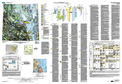
The Quaternary Geologic Map of the Winnipeg 4° × 6° Degree Quadrangle, United States and Canada, is a component of the U.S. Geological Survey Quaternary Geologic Atlas of the United States map series (Miscellaneous Investigations Series I-1420), an effort to produce 4° × 6° Quaternary geologic maps, at 1:1 million scale, of the entire conterminous United States and adjacent Canada. The map and the accompanying text and supplemental illustrations provide a regional overview of the areal distributions and characteristics of surficial deposits and materials of Quaternary age (~1.8 Ma to present) in parts of North Dakota, Minnesota, Manitoba, and Saskatchewan. The map is not a map of soils as soils are recognized in agriculture. Rather, it is a map of soils as recognized in engineering geology, or of substrata or parent materials in which agricultural soils are formed.
The map units are distinguished chiefly on the basis of (1)genesis (processes of origin) or environments of deposition: for example, sediments deposited primarily by glacial ice (glacial deposits or till), sediments deposited in lakes (lacustrine deposits), or sediments deposited by wind (eolian deposits); (2) age: for example, how long ago the deposits accumulated; (3) texture (grain size)of the deposits or materials; (4) composition (particle lithology) of the deposits or materials; (5) thickness; and (6) other physical, chemical, and engineering properties. Supplemental illustrations show (1) temporal correlation of the map units, (2) the areal relationships of late Wisconsin glacial ice lobes and sublobes, (3) temporal and spatial correlation of late Wisconsin glacial phases, readvance limits, and ice margin stillstands, (4) temporal and stratigraphic correlation of surface and subsurface glacial deposits in the Winnipeg quadrangle and in adjacent 4° × 6° quadrangles, and (5) responsibility for state and province compilations.
The database provides information related to geologic hazards (for example, materials that are characterized by expansive clay minerals; landslide deposits or landslide-prone deposits), natural resources (for example, sources of aggregate, peat, and clay; potential shallow sources of groundwater), and areas of environmental concern (for example, areas that are potentially suitable for specific ecosystem habitats; areas of potential soil and groundwater contamination). All of these aspects of the database relate directly to land use, management, and policy. The map, text, and accompanying illustrations provide a database of regional scope related to geologic history, climatic changes, the stratigraphic and chronologic frameworks of surface and subsurface deposits and materials of Quaternary age, and other problems and concerns.
Purpose:
The primary objectives were (1) to produce a map of surficial deposits and materials of Quaternary age in the Winnipeg 4° × 6° quadrangle, integrating the Quaternary geology across the International Boundary between North Dakota and Minnesota (in the United States), and Manitoba and Saskatchewan (in Canada), and (2) to compile descriptive information related to the deposits and materials. Based on that integration of data, a secondary objective was to reconstruct the stratigraphic and chronologic frameworks of the surface and subsurface glacial deposits and to reconstruct the glacial history in the region. The data set is a compilation and a synthesis of available data from the region.
Because of the generalization required to produce a map at 1:1 million scale, the map is intended for regional analysis, rather than for detailed analysis in specific areas.
Supplemental_Information:
The map data were compiled from many sources, including maps at scales as large as 1:24,000. Sources of information are listed in a 16-page pamphlet that accompanies the printed edition of the map. The pamphlet is also available online as a PDF file that accompanies the browse graphic for the map.
Most of the original map data were compiled at 1:250,000 scale by the compilers. Those data were provided to the editor/integrator by the compilers, at either 1:250,000 scale, 1:500,000 scale, or 1:1,000,000 scale. Data provided at smaller scales were photographically reduced to 1:1,000,000 scale by the editor/integrator.
The source data were greatly simplified or generalized for the purposes of this compilation. Consequently, this map, at 1:1,000,000 scale, is intended to be used for regional analysis, rather than for detailed analysis of specific areas in the region.
The digital file was prepared at 1:1,000,000 nominal viewing scale. If the map is enlarged to larger scales (for example, 1:250,000, 1:100,000, or 1:24,000 scale), resolution of the map data is greatly diminished. Enlargement will not restore resolution that was lost by simplification or generalization of data.
Time_Period_of_Content:
Time_Period_Information:
Range_of_Dates/Times:
Beginning_Date: 1976
Ending_Date: 1996
Currentness_Reference:
The Quaternary geology of the Winnipeg quadrangle was compiled 1976-85, 1987, and 1990-96.
Status:
Progress: Complete
Maintenance_and_Update_Frequency: None planned
Spatial_Domain:
Bounding_Coordinates:
West_Bounding_Coordinate: -102.0
East_Bounding_Coordinate: -96.0
North_Bounding_Coordinate: 52.0
South_Bounding_Coordinate: 48.0
Keywords:
Theme:
Theme_Keyword_Thesaurus: USGS Thesaurus
Theme_Keyword: geology
Theme_Keyword: geologic maps
Theme_Keyword: surficial geologic units
Theme_Keyword: unconsolidated deposits
Theme_Keyword: geospatial datasets
Theme_Keyword: Quaternary
Theme:
Theme_Keyword_Thesaurus: ISO 19115 Topic Categories
Theme_Keyword: geoscientificInformation
Theme:
Theme_Keyword_Thesaurus: National Geologic Map Database Catalog themes, augmented
Theme_Keyword: 3100 - Vector
Theme_Keyword: 3110 - ESRI
Theme_Keyword: 3112 - export
Theme_Keyword: 1100 - Geology
Theme_Keyword: 1101 - General
Theme:
Theme_Keyword_Thesaurus:
American Geological Institute (AGI) Glossary of Geology
Theme_Keyword: Alluvial fan deposit
Theme_Keyword: Alluvium
Theme_Keyword: Catastrophic flood
Theme_Keyword: Colluvium
Theme_Keyword: Corrugated moraine
Theme_Keyword: Debris-flow deposit
Theme_Keyword: Delta deposit
Theme_Keyword: Density-current underflow-fan deposit
Theme_Keyword: Dune
Theme_Keyword: Earthflow deposit
Theme_Keyword: End moraine
Theme_Keyword: Eolian deposit
Theme_Keyword: Esker
Theme_Keyword: Flood deposit
Theme_Keyword: Geologic history
Theme_Keyword: Geologic map
Theme_Keyword: Geology
Theme_Keyword: Glacial deposit
Theme_Keyword: GLacial history
Theme_Keyword: Glacial lake
Theme_Keyword: Glacial limit
Theme_Keyword: Glacial lobe
Theme_Keyword: Glacial sublobe
Theme_Keyword: Glaciation
Theme_Keyword: Glaciofluvial deposit
Theme_Keyword: Glaciotectonic deposit
Theme_Keyword: Glaciotectonic terrain
Theme_Keyword: Ground moraine
Theme_Keyword: Ice-contact deposit
Theme_Keyword: Interlobate moraine
Theme_Keyword: Kame
Theme_Keyword: Kame moraine
Theme_Keyword: Lacustrine deposit
Theme_Keyword: Limit of glaciation
Theme_Keyword: Minor moraine
Theme_Keyword: Muck
Theme_Keyword: Mudflow deposit
Theme_Keyword: Outwash deposit
Theme_Keyword: Paleosol
Theme_Keyword: Peat
Theme_Keyword: Quaternary stratigraphy
Theme_Keyword: Remanent geomagnetic polarity
Theme_Keyword: Sheetwash alluvium
Theme_Keyword: Slump-block deposit
Theme_Keyword: Stagnation moraine
Theme_Keyword: Surficial geology
Theme_Keyword: Swamp deposit
Theme_Keyword: Tephra
Theme_Keyword: Till
Theme_Keyword: Washboard moraine
Theme_Keyword: Weathered zone
Place:
Place_Keyword_Thesaurus:
U.S. Board on Geographic Names (BGN) Geographic Names Information System (GNIS) and Gazateer of Canada (Natural Resources Canada)
Place_Keyword: Canada
Place_Keyword: Duck Mountain
Place_Keyword: Lake Manitoba
Place_Keyword: Lake Winnipeg
Place_Keyword: Manitoba
Place_Keyword: Minnesota
Place_Keyword: North Dakota
Place_Keyword: Riding Mountain
Place_Keyword: Saskatchewan
Place_Keyword: Turtle Mountain
Place_Keyword: United States
Temporal:
Temporal_Keyword_Thesaurus:
American Geological Institute (AGI) Glossary of Geology
Temporal_Keyword: Calibrated (CAL) age
Temporal_Keyword: Early Wisconsin
Temporal_Keyword: Holocene
Temporal_Keyword: Illinoian
Temporal_Keyword: Late Wisconsin
Temporal_Keyword: Middle Wisconsin
Temporal_Keyword: Pleistocene
Temporal_Keyword: Pliocene
Temporal_Keyword: Pre-Illinoian
Temporal_Keyword: Pre-Wisconsin
Temporal_Keyword: Quaternary
Temporal_Keyword: Radiocarbon age
Temporal_Keyword: Sangamon
Temporal_Keyword: Tertiary
Temporal_Keyword: Wisconsin
Place:
Place_Keyword_Thesaurus: Augmented FIPS 10-4 and FIPS 6-4
Place_Keyword: CA03 = Manitoba
Place_Keyword: CA11 = Saskatchewan
Place_Keyword: US27 = Minnesota
Place_Keyword: US38 = North Dakota
Access_Constraints: None
Use_Constraints:
Acknowledgment of the Quaternary Geologic Atlas of the United States and (or) the U.S. Geological Survey in products derived from these data will be appreciated.
Point_of_Contact:
Contact_Information:
Contact_Person_Primary:
Contact_Person: David S. Fullerton
Contact_Organization: U.S. Geological Survey
Contact_Address:
Address_Type: Mailing
Address: Box 25046, Mail Stop 913, Denver Federal Center
City: Denver
State_or_Province: Colorado
Postal_Code: 80225
Country: USA
Contact_Voice_Telephone: (303) 236-1232
Contact_Facsimile_Telephone: (303) 236-0214
Contact_Electronic_Mail_Address: fullerton@usgs.gov
Browse_Graphic:
Browse_Graphic_File_Name: http://pubs.usgs.gov/imap/i-1420/nm-14/i-1420.gif
Browse_Graphic_File_Description: Low-resolution image of the entire map sheet.
Browse_Graphic_File_Type: GIF
Browse_Graphic:
Browse_Graphic_File_Name: http://pubs.usgs.gov/imap/i-1420/nm-14/I-1420_nm-14_screen.pdf
Browse_Graphic_File_Description:
Complete map layout, including supplemental illustrations, correlation diagram, full description of map units and symbols, and location and description of 43 stratigraphic sections. An accompanying pamphlet contains references cited.
Browse_Graphic_File_Type: PDF
Data_Set_Credit:
The Quaternary geology of the Winnipeg quadrangle was compiled by David S. Fullerton, U.S. Geological Survey, Susan M. Ringrose, Manitoba Department of Energy and Mines, Lee Clayton, North Dakota Geological Survey, Bryan T. Schreiner, Saskatchewan Research Council, and Joseph E. Goebel, Minnesota Geological Survey; the state and province compilations were edited and integrated by David S. Fullerton; the draft compilation was converted to digital form by Techni Graphic Systems, Inc., of Fort Collins, CO, under contract with the U.S. Geological Survey, and by Nancy Shock, U.S. Geological Survey. The map was edited and the digitized product proofread by Diane E. Lane, U.S. Geological Survey.
Native_Data_Set_Environment: ARC/INFO v. 7.2.1, Solaris 2.6.
Data_Quality_Information:
Attribute_Accuracy:
Attribute_Accuracy_Report:
Compilation of geologic data: The accuracy of the map data is dependent on (1) the accuracy of the original source data, (2) the accuracy of transfer of that data to larger scale bases by the compilers, (3) the procedures by which the compilers and the editor/integrator simplified or generalized the data, and (4) the procedures used by, and the objectivity exercised by, the editor/integrator in integration of adjacent parts of the map that were prepared by different compilers. Consequently, aspects of accuracy for the data set cannot be quantified.
Digitization and attributing of hand-drafted compilation: Digitizing contractor scanned source stable-base material, vectorized scan, attributed files from author drafting and annotations, and produced check plots and coverages. First author and map editor proofread check plots, and digital map specialist reviewed digital files. Digitizing contractor corrected attributing as needed and produced new check plots. Digital map specialist and editor proofread new check plots and reviewed digital files, making final corrections as needed; editor imported files into graphics program to prepare cartographic product. First author proofread cartographic product (the map sheet layout and pamphlet). This map was thoroughly reviewed for conformity with U.S. Geological Survey editorial standards and stratigraphic nomenclature.
Logical_Consistency_Report:
Most of the map data were compiled from published and unpublished maps at larger scales. The map data, text information, and data used to produce the supplemental illustrations were obtained from many sources, listed in "Sources of Information." The map and text data provided by the compilers were integrated by the editor, and supplemental data (for example, some of the symbols on the map), from listed sources, were added by the editor. The data were compiled and integrated in 1976-85, 1987, and 1990-96. The time period represented by specific data is not specified.
Completeness_Report:
The map data from Manitoba in the northeastern part of the quadrangle and in the eastern part of the quadrangle north of Minnesota were derived primarily from a single source (Nielsen, Erik, Ringrose, S.M., Matile, G.L.D., Groom, Heather, Mihychuk, M.A., and Conley, G.G., 1981, Surficial Geologic Map of Manitoba: Manitoba Department of Energy and Mines Mineral Resources Map 81-1, scale 1:1,000,000). The compiler for that region was not available to update that compilation in 1990-96, and most of the other sources of information related to that region in Manitoba (listed in "Sources of Information") were not available to the editor.
Positional_Accuracy:
Horizontal_Positional_Accuracy:
Horizontal_Positional_Accuracy_Report:
The accuracy of location of polygons, lines, and points is consistent with the map scale of 1:1,000,000.
Lineage:
Process_Step:
Process_Description:
Digitizing contractor scanned source stable-base material, vectorized scan, attributed files from author drafting and annotations, and produced check plots and coverages.
Process_Date: 1999
Process_Step:
Process_Description:
First author and map editor proofread check plots, and digital map specialist reviewed digital files.
Process_Date: 1999
Process_Step:
Process_Description:
Digitizing contractor corrected attributing as needed and produced new check plots.
Process_Date: 1999
Process_Step:
Process_Description:
Digital map specialist and editor proofread new check plots and reviewed digital files, making final corrections as needed; editor imported files into graphics program to prepare cartographic product.
Process_Date: 1999
Process_Step:
Process_Description:
Cartographic product printed; digital files for database and PDF files of cartographic product placed on ftp server.
Process_Date: 2000
Process_Step:
Process_Description: Creation of original metadata record
Process_Date: 20000706
Process_Contact:
Contact_Information:
Contact_Person_Primary:
Contact_Person: Diane E. Lane
Contact_Organization:
U.S. Geological Survey, Geologic Division, Central Publications Group
Contact_Position: Geologic Map Editor
Contact_Address:
Address_Type: Mailing
Address:
U.S. Geological Survey, Mail Stop 902
Box 25046, Denver Federal Center
City: Denver
State_or_Province: CO
Postal_Code: 80225
Country: USA
Contact_Voice_Telephone: (303) 236-5476
Contact_Facsimile_Telephone: (303) 236-6287
Contact_Electronic_Mail_Address: delane@usgs.gov
Spatial_Data_Organization_Information:
Direct_Spatial_Reference_Method: Vector
Spatial_Reference_Information:
Horizontal_Coordinate_System_Definition:
Planar:
Map_Projection:
Map_Projection_Name: Lambert Conformal Conic
Lambert_Conformal_Conic:
Standard_Parallel: 48.6666666667
Standard_Parallel: 51.3333333333
Longitude_of_Central_Meridian: -99.00
Latitude_of_Projection_Origin: 0.0
False_Easting: 0
False_Northing: 0
Planar_Coordinate_Information:
Planar_Coordinate_Encoding_Method: Coordinate pair
Planar_Distance_Units: Meters
Geodetic_Model:
Horizontal_Datum_Name: North American Datum of 1927
Ellipsoid_Name: Clarke 1866
Semi-major_Axis: 6378206.4
Denominator_of_Flattening_Ratio: 294.98
Entity_and_Attribute_Information:
Detailed_Description:
Entity_Type:
Entity_Type_Label: geo_net.pat
Entity_Type_Definition: Polygons defined in geo_net.pat
Attribute:
Attribute_Label: name
Attribute_Definition: Abbreviation for the type of deposit the polygon represents.
Attribute_Domain_Values:
Enumerated_Domain:
Enumerated_Domain_Value: ed
Enumerated_Domain_Value_Definition: Dune sand (Holocene)
Attribute_Domain_Values:
Enumerated_Domain:
Enumerated_Domain_Value: eu
Enumerated_Domain_Value_Definition: Eolian sheet sand and silt (Holocene)
Attribute_Domain_Values:
Enumerated_Domain:
Enumerated_Domain_Value: hp
Enumerated_Domain_Value_Definition: Peat and muck (Holocene)
Attribute_Domain_Values:
Enumerated_Domain:
Enumerated_Domain_Value: al
Enumerated_Domain_Value_Definition: Alluvium (Holocene and Late Wisconsin)
Attribute_Domain_Values:
Enumerated_Domain:
Enumerated_Domain_Value: afj
Enumerated_Domain_Value_Definition: Alluvial-fan deposit (Holocene and Late Wisconsin)
Attribute_Domain_Values:
Enumerated_Domain:
Enumerated_Domain_Value: lca
Enumerated_Domain_Value_Definition: Lake clay and silt (Holocene and Late Wisconsin)
Attribute_Domain_Values:
Enumerated_Domain:
Enumerated_Domain_Value: lss
Enumerated_Domain_Value_Definition: Lake silt and sand (Holocene and Late Wisconsin)
Attribute_Domain_Values:
Enumerated_Domain:
Enumerated_Domain_Value: lsa
Enumerated_Domain_Value_Definition: Lake sand and gravel (Holocene and Late Wisconsin)
Attribute_Domain_Values:
Enumerated_Domain:
Enumerated_Domain_Value: lu
Enumerated_Domain_Value_Definition: Lake clay, silt, sand, and gravel (Holocene and Late Wisconsin)
Attribute_Domain_Values:
Enumerated_Domain:
Enumerated_Domain_Value: jea
Enumerated_Domain_Value_Definition:
Slump-block, earthflow, debris-flow, and mudflow landslide deposits (Holocene and Late Wisconsin)
Attribute_Domain_Values:
Enumerated_Domain:
Enumerated_Domain_Value: caa
Enumerated_Domain_Value_Definition:
Colluvium, sheetwash alluvium, and landslide deposits (Holocene and Late Wisconsin)
Attribute_Domain_Values:
Enumerated_Domain:
Enumerated_Domain_Value: hs
Enumerated_Domain_Value_Definition: Swamp deposit (Holocene and Late Wisconsin)
Attribute_Domain_Values:
Enumerated_Domain:
Enumerated_Domain_Value: tc
Enumerated_Domain_Value_Definition: Clayey till, ground moraine (Late Wisconsin)
Attribute_Domain_Values:
Enumerated_Domain:
Enumerated_Domain_Value: tc(e)
Enumerated_Domain_Value_Definition: Clayey till, end moraine (Late Wisconsin)
Attribute_Domain_Values:
Enumerated_Domain:
Enumerated_Domain_Value: tlg
Enumerated_Domain_Value_Definition: Loamy till (Late Wisconsin)
Attribute_Domain_Values:
Enumerated_Domain:
Enumerated_Domain_Value: tku
Enumerated_Domain_Value_Definition: Loamy till, ground moraine (Late Wisconsin)
Attribute_Domain_Values:
Enumerated_Domain:
Enumerated_Domain_Value: tku(e)
Enumerated_Domain_Value_Definition: Loamy till, end moraine (Late Wisconsin)
Attribute_Domain_Values:
Enumerated_Domain:
Enumerated_Domain_Value: tkr
Enumerated_Domain_Value_Definition: Loamy till, discontinuous loamy till (Late Wisconsin)
Attribute_Domain_Values:
Enumerated_Domain:
Enumerated_Domain_Value: tlx
Enumerated_Domain_Value_Definition: Loamy till, ground moraine (Late Wisconsin)
Attribute_Domain_Values:
Enumerated_Domain:
Enumerated_Domain_Value: tlx(q)
Enumerated_Domain_Value_Definition: Loamy till, flood-scoured till (Late Wisconsin)
Attribute_Domain_Values:
Enumerated_Domain:
Enumerated_Domain_Value: tlx(e)
Enumerated_Domain_Value_Definition: Loamy till, end moraine (Late Wisconsin)
Attribute_Domain_Values:
Enumerated_Domain:
Enumerated_Domain_Value: tlx(s)
Enumerated_Domain_Value_Definition: Loamy till, stagnation moraine (Late Wisconsin)
Attribute_Domain_Values:
Enumerated_Domain:
Enumerated_Domain_Value: tlr
Enumerated_Domain_Value_Definition: Loamy till, discontinous loamy till (Late Wisconsin)
Attribute_Domain_Values:
Enumerated_Domain:
Enumerated_Domain_Value: tlw
Enumerated_Domain_Value_Definition: Loamy till, ground moraine (Late Wisconsin)
Attribute_Domain_Values:
Enumerated_Domain:
Enumerated_Domain_Value: tlw(e)
Enumerated_Domain_Value_Definition: Loamy till, end moraine (Late Wisconsin)
Attribute_Domain_Values:
Enumerated_Domain:
Enumerated_Domain_Value: tsr
Enumerated_Domain_Value_Definition: Discontinuous sandy till (Late Wisconsin)
Attribute_Domain_Values:
Enumerated_Domain:
Enumerated_Domain_Value: ke
Enumerated_Domain_Value_Definition: Kame moraine deposit (Late Wisconsin)
Attribute_Domain_Values:
Enumerated_Domain:
Enumerated_Domain_Value: kg
Enumerated_Domain_Value_Definition: Ice-contact sand and gravel (Late Wisconsin)
Attribute_Domain_Values:
Enumerated_Domain:
Enumerated_Domain_Value: ks
Enumerated_Domain_Value_Definition: Ice-contact sand (Late Wisconsin)
Attribute_Domain_Values:
Enumerated_Domain:
Enumerated_Domain_Value: gk
Enumerated_Domain_Value_Definition: Outwash and ice-contact gravel, sand, and silt (Late Wisconsin)
Attribute_Domain_Values:
Enumerated_Domain:
Enumerated_Domain_Value: gg
Enumerated_Domain_Value_Definition: Outwash sand and gravel (Late Wisconsin)
Attribute_Domain_Values:
Enumerated_Domain:
Enumerated_Domain_Value: gs
Enumerated_Domain_Value_Definition: Outwash sand and silt (Late Wisconsin)
Attribute_Domain_Values:
Enumerated_Domain:
Enumerated_Domain_Value: aqa
Enumerated_Domain_Value_Definition: Flood deposits (Late Wisconsin)
Attribute_Domain_Values:
Enumerated_Domain:
Enumerated_Domain_Value: aqb
Enumerated_Domain_Value_Definition: Flood deposits and flood-scoured till (Late Wisconsin)
Attribute_Domain_Values:
Enumerated_Domain:
Enumerated_Domain_Value: lda
Enumerated_Domain_Value_Definition: Lake density-current underflow-fan deposit (Late Wisconsin)
Attribute_Domain_Values:
Enumerated_Domain:
Enumerated_Domain_Value: ldb
Enumerated_Domain_Value_Definition: Lake delta deposit (Late Wisconsin)
Attribute_Domain_Values:
Enumerated_Domain:
Enumerated_Domain_Value: IT
Enumerated_Domain_Value_Definition: Glaciotectonic deposits
Attribute_Domain_Values:
Enumerated_Domain:
Enumerated_Domain_Value: water
Enumerated_Domain_Value_Definition:
Open water (only the largest lakes were attributed as open water).
Attribute:
Attribute_Label: geocode
Attribute_Definition: general type of polygon
Attribute_Domain_Values:
Enumerated_Domain:
Enumerated_Domain_Value: (blank)
Attribute_Domain_Values:
Enumerated_Domain:
Enumerated_Domain_Value: IT
Attribute_Domain_Values:
Enumerated_Domain:
Enumerated_Domain_Value: map unit
Enumerated_Domain_Value_Definition:
polygon is a geologic unit whose type is indicated by the attribute "name"
Attribute_Domain_Values:
Enumerated_Domain:
Enumerated_Domain_Value: open water
Detailed_Description:
Entity_Type:
Entity_Type_Label: geo_net.aat
Entity_Type_Definition: Linear features described in the geo_net coverage
Attribute:
Attribute_Label: accuracy
Attribute_Definition:
An indication of the certainty with which a line's position is known.
Attribute_Domain_Values:
Enumerated_Domain:
Enumerated_Domain_Value: (blank)
Enumerated_Domain_Value_Definition: position is approximate or inferred
Attribute_Domain_Values:
Enumerated_Domain:
Enumerated_Domain_Value: certain
Enumerated_Domain_Value_Definition: position is determined objectively
Attribute:
Attribute_Label: geocode_l
Attribute_Definition: General nature of the line
Attribute_Domain_Values:
Enumerated_Domain:
Enumerated_Domain_Value: colorboundary
Attribute_Domain_Values:
Enumerated_Domain:
Enumerated_Domain_Value: contact
Enumerated_Domain_Value_Definition:
Intersection between the surface of the earth and the surface defined by abutting geologic units
Attribute_Domain_Values:
Enumerated_Domain:
Enumerated_Domain_Value: shoreline
Detailed_Description:
Entity_Type:
Entity_Type_Label: stru_lin.aat
Entity_Type_Definition: Lines defined in the coverage stru_lin
Attribute:
Attribute_Label: accuracy
Attribute_Definition: accuracy of location of arcs in the stru_lin coverage
Attribute_Domain_Values:
Enumerated_Domain:
Enumerated_Domain_Value: certain
Attribute_Domain_Values:
Enumerated_Domain:
Enumerated_Domain_Value: concealed
Attribute_Domain_Values:
Enumerated_Domain:
Enumerated_Domain_Value: inferred
Attribute:
Attribute_Label: geocode
Attribute_Definition:
Inferred geologic nature of the line. Most of the ice-molded landform features are point features on the geo_pnt coverage that have an orientation but were treated as features of arbitrary length. The actual lengths of a few ice-molded landforms along the south edge of the map area are shown; these arcs are included with the stru_lin coverage.
NOTE: The direction of the arcs is significant in that it determines on which side of the arc tics or other decorations are placed to show the side of glacial advance. If these coverages are cleaned the arcs can 'flip' and the tics will end up on the incorrect side of the arc. Please refer to the graphic file for correct placement of tics and other decorations.
Attribute_Domain_Values:
Enumerated_Domain:
Enumerated_Domain_Value: distal margin of glaciotectonic terraine
Attribute_Domain_Values:
Enumerated_Domain:
Enumerated_Domain_Value: esker
Attribute_Domain_Values:
Enumerated_Domain:
Enumerated_Domain_Value: glaciotectonic raft
Attribute_Domain_Values:
Enumerated_Domain:
Enumerated_Domain_Value: ice-molded landform
Attribute_Domain_Values:
Enumerated_Domain:
Enumerated_Domain_Value: limit of glacial advance
Attribute_Domain_Values:
Enumerated_Domain:
Enumerated_Domain_Value: washboard moraine
Detailed_Description:
Entity_Type:
Entity_Type_Label: geo_pnt.pat
Entity_Type_Definition:
Points that mark the extent of dune fields and points that show location of ice-molded landforms (drumlins, rock drumlins, flutes, or grooves)
Attribute:
Attribute_Label: geocode
Attribute_Definition: Type of point
Attribute_Domain_Values:
Enumerated_Domain:
Enumerated_Domain_Value: dune
Attribute_Domain_Values:
Enumerated_Domain:
Enumerated_Domain_Value: ice-molded landform
Attribute:
Attribute_Label: azimuth
Attribute_Definition:
Orientation of ice-molded landform, relative to geographic (true) north, with positive values counter-clockwise (a value of 90 is due west).
Attribute_Domain_Values:
Range_Domain:
Range_Domain_Minimum: 0
Range_Domain_Maximum: 360
Attribute_Units_of_Measure: degree
Attribute_Measurement_Resolution: 1
Detailed_Description:
Entity_Type:
Entity_Type_Label: pnt_sym.pat
Entity_Type_Definition:
Points that show location of dunes whose orientations indicate wind direction and striations that indicate direction of ice movement.
Attribute:
Attribute_Label: type
Attribute_Definition: Surface process inferred at the indicated point
Attribute_Domain_Values:
Enumerated_Domain:
Enumerated_Domain_Value: ice movement
Attribute_Domain_Values:
Enumerated_Domain:
Enumerated_Domain_Value: wind direction
Attribute:
Attribute_Label: azimuth
Attribute_Definition:
Orientation of ice movement or wind, relative to geographic (true) north. Positive values counter-clockwise (90 is due west).
Attribute_Domain_Values:
Range_Domain:
Range_Domain_Minimum: 0
Range_Domain_Maximum: 360
Attribute_Units_of_Measure: degrees
Attribute_Measurement_Resolution: 1
Detailed_Description:
Entity_Type:
Entity_Type_Label: data_pnt.pat
Entity_Type_Definition:
Points that show locations of important stratigraphic sections; these sections are described in a pamphlet that accompanies the printed map sheet
Attribute:
Attribute_Label: geocode
Attribute_Definition:
This attribute identifies the point as an endpoint of one of the stratigraphic sections shown on the printed map sheet.
Attribute_Domain_Values:
Enumerated_Domain:
Enumerated_Domain_Value: location of section
Attribute:
Attribute_Label: section#
Attribute_Definition:
The number of the section of which this point is an endpoint. Section numbers are arbitrary integers.
Attribute_Domain_Values:
Range_Domain:
Range_Domain_Minimum: 1
Range_Domain_Maximum: 43
Detailed_Description:
Entity_Type:
Entity_Type_Label: data_net.aat
Entity_Type_Definition: Arcs that form the quadrangle boundary
Attribute:
Attribute_Label: geocode_l
Attribute_Definition: Indicates the role of the arc
Attribute_Domain_Values:
Enumerated_Domain:
Enumerated_Domain_Value: neatline
Enumerated_Domain_Value_Definition:
The arc forms part of the neatline, the boundary of the mapped area.
Overview_Description:
Entity_and_Attribute_Overview:
The dataset for the Winnipeg quadrangle consists of seven coverages:
grfx_pnt
geo_net
stru_lin
geo_pnt
pnt_sym
data_pnt
data_net
The coverage grfx_pnt is not a "true" ARC/INFO coverage. It contains graphic representations of symbols used on the geologic map and included in the coverages data_pnt, geo_pnt, and pnt_sym.
The dataset also includes grfx_pnt.dxf, a dxf file derived from grfx_pnt, and wingx.shp, a shapefile derived from grfx_pnt.dxf. The file wingx.shp is readily imported into graphics programs and will import as the graphics symbols shown on the printed edition of the map layout and in the pdf file that accompanies the dataset.
Entity_and_Attribute_Detail_Citation:
Additional information is available on the printed map sheets, which are provided in PDF along with the data:
I-1420_nm-14_screen.pdf   -- a screen-optimized PDF file of the map sheet
I-1420_nm-14_print.pdf    -- a print-optimized PDF file of the map sheet
I-1420_nm-14_pamphlet.pdf -- a PDF file of the 16-page pamphlet that lists sources of data used in compilation of this map
I-1420_nm-14_jacket.pdf   -- a PDF file of the map jacket
Distribution_Information:
Distributor:
Contact_Information:
Contact_Organization_Primary:
Contact_Organization: U.S. Geological Survey
Contact_Address:
Address_Type: Mailing
Address:
U.S. Geological Survey Information Services
Box 25286, Denver Federal Center
City: Denver
State_or_Province: CO
Postal_Code: 80225
Country: USA
Contact_Voice_Telephone: 1-888-ASK-USGS
Resource_Description:
Miscellaneous Investigations Series Map I-1420 (NM-14), "Quaternary Geologic Map of the Winnipeg 4° × 6° Quadrangle, United States and Canada"
Distribution_Liability:
Any use of trade, product, or firm names is for descriptive purposes only and does not imply endorsement by the U.S. Government. Although this data set has been used by the U.S. Geological Survey, no warranty, expressed or implied, is made by the USGS as to the accuracy and functioning of the data set and related material nor shall the fact of distribution constitute any such warranty, and no responsibility is assumed by the USGS in connection therewith.
Standard_Order_Process:
Digital_Form:
Digital_Transfer_Information:
Format_Name: ARCE
Format_Version_Number: 7.2.1
File_Decompression_Technique: unzip
Digital_Transfer_Option:
Online_Option:
Computer_Contact_Information:
Network_Address:
Fees: none
Metadata_Reference_Information:
Metadata_Date: 20160613
Metadata_Contact:
Contact_Information:
Contact_Person_Primary:
Contact_Person: Peter N Schweitzer
Contact_Organization: USGS Midwest Area
Contact_Position:
Collection manager, USGS Geoscience Data Clearinghouse, http://geo-nsdi.er.usgs.gov/
Contact_Address:
Address_Type: mailing address
Address:
Mail Stop 954
12201 Sunrise Valley Dr
City: Reston
State_or_Province: VA
Postal_Code: 20192-0002
Country: USA
Contact_Voice_Telephone: 703-648-6533
Contact_Facsimile_Telephone: 703-648-6252
Contact_Electronic_Mail_Address: pschweitzer@usgs.gov
Metadata_Standard_Name: Content Standard for Digital Geospatial Metadata
Metadata_Standard_Version: FGDC-STD-001-1998

This page is <https://geo-nsdi.er.usgs.gov/metadata/map-i/1420/NM-14/metadata.html>
Generated by mp version 2.9.48 on Tue Jul 03 20:04:46 2018