Online Links:
| Value | Definition |
|---|---|
| ed | Dune sand (Holocene) |
| eu | Eolian sheet sand and silt (Holocene) |
| hp | Peat and muck (Holocene) |
| al | Alluvium (Holocene and Late Wisconsin) |
| afj | Alluvial-fan deposit (Holocene and Late Wisconsin) |
| lca | Lake clay and silt (Holocene and Late Wisconsin) |
| lss | Lake silt and sand (Holocene and Late Wisconsin) |
| lsa | Lake sand and gravel (Holocene and Late Wisconsin) |
| lu | Lake clay, silt, sand, and gravel (Holocene and Late Wisconsin) |
| jea | Slump-block, earthflow, debris-flow, and mudflow landslide deposits (Holocene and Late Wisconsin) |
| caa | Colluvium, sheetwash alluvium, and landslide deposits (Holocene and Late Wisconsin) |
| hs | Swamp deposit (Holocene and Late Wisconsin) |
| tc | Clayey till, ground moraine (Late Wisconsin) |
| tc(e) | Clayey till, end moraine (Late Wisconsin) |
| tlg | Loamy till (Late Wisconsin) |
| tku | Loamy till, ground moraine (Late Wisconsin) |
| tku(e) | Loamy till, end moraine (Late Wisconsin) |
| tkr | Loamy till, discontinuous loamy till (Late Wisconsin) |
| tlx | Loamy till, ground moraine (Late Wisconsin) |
| tlx(q) | Loamy till, flood-scoured till (Late Wisconsin) |
| tlx(e) | Loamy till, end moraine (Late Wisconsin) |
| tlx(s) | Loamy till, stagnation moraine (Late Wisconsin) |
| tlr | Loamy till, discontinous loamy till (Late Wisconsin) |
| tlw | Loamy till, ground moraine (Late Wisconsin) |
| tlw(e) | Loamy till, end moraine (Late Wisconsin) |
| tsr | Discontinuous sandy till (Late Wisconsin) |
| ke | Kame moraine deposit (Late Wisconsin) |
| kg | Ice-contact sand and gravel (Late Wisconsin) |
| ks | Ice-contact sand (Late Wisconsin) |
| gk | Outwash and ice-contact gravel, sand, and silt (Late Wisconsin) |
| gg | Outwash sand and gravel (Late Wisconsin) |
| gs | Outwash sand and silt (Late Wisconsin) |
| aqa | Flood deposits (Late Wisconsin) |
| aqb | Flood deposits and flood-scoured till (Late Wisconsin) |
| lda | Lake density-current underflow-fan deposit (Late Wisconsin) |
| ldb | Lake delta deposit (Late Wisconsin) |
| IT | Glaciotectonic deposits |
| water | Open water (only the largest lakes were attributed as open water). |
| Value | Definition |
|---|---|
| (blank) | |
| IT | |
| map unit | polygon is a geologic unit whose type is indicated by the attribute "name" |
| open water |
| Value | Definition |
|---|---|
| (blank) | position is approximate or inferred |
| certain | position is determined objectively |
| Value | Definition |
|---|---|
| colorboundary | |
| contact | Intersection between the surface of the earth and the surface defined by abutting geologic units |
| shoreline |
| Value | Definition |
|---|---|
| certain | |
| concealed | |
| inferred |
| Value | Definition |
|---|---|
| distal margin of glaciotectonic terraine | |
| esker | |
| glaciotectonic raft | |
| ice-molded landform | |
| limit of glacial advance | |
| washboard moraine |
| Value | Definition |
|---|---|
| dune | |
| ice-molded landform |
| Range of values | |
|---|---|
| Minimum: | 0 |
| Maximum: | 360 |
| Units: | degree |
| Resolution: | 1 |
| Value | Definition |
|---|---|
| ice movement | |
| wind direction |
| Range of values | |
|---|---|
| Minimum: | 0 |
| Maximum: | 360 |
| Units: | degrees |
| Resolution: | 1 |
| Value | Definition |
|---|---|
| location of section |
| Range of values | |
|---|---|
| Minimum: | 1 |
| Maximum: | 43 |
| Value | Definition |
|---|---|
| neatline | The arc forms part of the neatline, the boundary of the mapped area. |
grfx_pnt
geo_net
stru_lin
geo_pnt
pnt_sym
data_pnt
data_net
The coverage grfx_pnt is not a "true" ARC/INFO coverage. It contains graphic representations of symbols used on the geologic map and included in the coverages data_pnt, geo_pnt, and pnt_sym.
I-1420_nm-14_screen.pdf   -- a screen-optimized PDF file of the map sheet
I-1420_nm-14_print.pdf    -- a print-optimized PDF file of the map sheet
I-1420_nm-14_pamphlet.pdf -- a PDF file of the 16-page pamphlet that lists sources of data used in compilation of this map
I-1420_nm-14_jacket.pdf   -- a PDF file of the map jacket
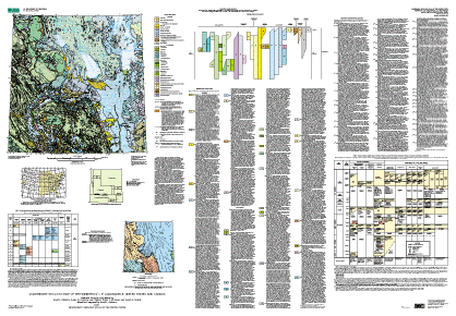
The Quaternary geology of the Winnipeg quadrangle was compiled by David S. Fullerton, U.S. Geological Survey, Susan M. Ringrose, Manitoba Department of Energy and Mines, Lee Clayton, North Dakota Geological Survey, Bryan T. Schreiner, Saskatchewan Research Council, and Joseph E. Goebel, Minnesota Geological Survey; the state and province compilations were edited and integrated by David S. Fullerton; the draft compilation was converted to digital form by Techni Graphic Systems, Inc., of Fort Collins, CO, under contract with the U.S. Geological Survey, and by Nancy Shock, U.S. Geological Survey. The map was edited and the digitized product proofread by Diane E. Lane, U.S. Geological Survey.
The primary objectives were (1) to produce a map of surficial deposits and materials of Quaternary age in the Winnipeg 4° × 6° quadrangle, integrating the Quaternary geology across the International Boundary between North Dakota and Minnesota (in the United States), and Manitoba and Saskatchewan (in Canada), and (2) to compile descriptive information related to the deposits and materials. Based on that integration of data, a secondary objective was to reconstruct the stratigraphic and chronologic frameworks of the surface and subsurface glacial deposits and to reconstruct the glacial history in the region. The data set is a compilation and a synthesis of available data from the region.
Because of the generalization required to produce a map at 1:1 million scale, the map is intended for regional analysis, rather than for detailed analysis in specific areas.
Are there legal restrictions on access or use of the data?Access_Constraints: None
Use_Constraints:Acknowledgment of the Quaternary Geologic Atlas of the United States and (or) the U.S. Geological Survey in products derived from these data will be appreciated.
Any use of trade, product, or firm names is for descriptive purposes only and does not imply endorsement by the U.S. Government. Although this data set has been used by the U.S. Geological Survey, no warranty, expressed or implied, is made by the USGS as to the accuracy and functioning of the data set and related material nor shall the fact of distribution constitute any such warranty, and no responsibility is assumed by the USGS in connection therewith.
| Data format: | ARCE (version 7.2.1) |
|---|---|
| Network links: |
http://pubs.usgs.gov/imap/i-1420/nm-14/wnpg1.ZIP |