Geologic map of the Fawnskin 7.5' quadrangle, San Bernardino County, California

Metadata also available as - [Questions & Answers] - [Parseable text] - [XML]

Metadata:

Identification_Information:
Citation:
Citation_Information:
Originator: F.K. Miller
Originator: J.C. Matti
Originator: H.J. Brown
Originator: R.E. Powell
Publication_Date: 1998
Title:
Geologic map of the Fawnskin 7.5' quadrangle, San Bernardino County, California
Edition: Version 1.1
Geospatial_Data_Presentation_Form: vector digital data
Series_Information:
Series_Name: U.S. Geological Survey Open-File Report
Issue_Identification: 98-579
Publication_Information:
Publication_Place: Menlo Park, California
Publisher: U.S. Geological Survey
Online_Linkage: http://pubs.usgs.gov/of/1998/0579/
Description:
Abstract:
This data set maps and describes the geology of the Fawnskin 7.5' quadrangle, San Bernardino County, California and contains original U.S. Geological Survey data generated by detailed field observation and by interpretation of aerial photographs. The geologic map covers part of the northern San Bernardino Mountains. Bedrock units in the San Bernardino Mountains are dominated by large Cretaceous and Jurassic granitic bodies ranging in composition from monzogranite to gabbro, and include lesser Triassic monzonite. These granitic rocks intrude highly faulted and folded Late Proterozoic and Paleozoic formations representative of those found in the southern Great Basin. Low-angle thrust faults, many of them complexly folded, cut the Late Proterozoic and Paleozoic formations. A large, deformed cataclastic zone in the western part of the quadrangle cuts pre-Late Cretaceous units, and is intruded by Late Cretaceous plutons. Spanning the Pleistocene in age, large alluvial fans flank the north side of the mountains, and are dominated by debris flow deposits. Young, south dipping reverse faults, some with moderately to well eroded fault scarps, discontinuously flank the northern edge of the mountains. Young and old high-angle faults are mapped within the range.
Created using Environmental Systems Research Institute's ARC/INFO software, the database consists of the following items: (1) a map coverage containing faults, geologic contacts and units, (2) a coverage showing structural point data, (3) a coverage containing linear structural data, (4) a coverage showing geologic line ornamentation and (5) six additional INFO data tables (.rel) that contain detailed, coded, geologic information such as texture, fabric, color, and mineralogy,. These additional data are accessible to the user through the utilization of ARC/INFO relate environments and provide the user access to as much or as little of the encoded data as required. In addition, the data set includes the following graphic and text products: (1) A PostScript graphic plot-file containing the geologic map, topography, cultural data, a Correlation of Map Units (CMU) diagram, a Description of Map Units (DMU), and a key for point and line symbols; (2) PDF files of this Readme (including the metadata file as an appendix), Description of Map Units (DMU), and a screen graphic of the plot produced by the PostScript plot file.
The geologic map database contains original U.S. Geological Survey data generated by detailed field observation and by interpretation of aerial photographs. Within the database, geologic contacts are represented as lines (arcs), geologic units as polygons, and site-specific data as points. Polygon, arc, and point attribute tables (.pat, .aat, and .pat, respectively) uniquely identify each geologic datum.
Version 1.1 of this digital release differs from Version 1.0 mainly by changes and additions to conform to the more recently released digital geologic map of the Butler Peak quadrangle (OF 00-145), which adjoins the Fawnskin quadrangle on the west. Along the western edge of the quadrangle several polygons of Quaternary units are added and the names of several are changed. Colors of some granitic units are changed to conform to colors assigned to the same units in the Butler Peak quadrangle.
Purpose:
The data set for the Fawnskin quadrangle has been prepared by the Southern California Areal Mapping Project (SCAMP), a cooperative project sponsored jointly by the U.S. Geological Survey and the California Division of Mines and Geology, as part of an ongoing effort to utilize a Geographical Information System (GIS) format to create a regional digital geologic database for southern California. This regional database is being developed as a contribution to the National Geologic Map Data Base of the National Cooperative Geologic Mapping Program ofthe USGS. Development of the data set for the Fawnskin quadrangle has also been supported by the U.S. Forest Service, San Bernardino National Forest.
The digital geologic map database for the Fawnskin quadrangle has been created as a general-purpose data set that is applicable to other land-related investigations in the earth and biological sciences. For example, the U.S. Forest Service, San Bernardino National Forest, is using the database as part of a study of an endangered plant species, California Buckwheat, that shows preference for particular rock types. The Fawnskin database is not suitable for site-specific geologic evaluations at scales greater than 1:24,000 (1 in = 2,000 ft).
Supplemental_Information:
Within the geologic map database, map units are identified by standard geologic map criteria such as formation-name, age, and lithology. The authors have attempted to adhere to the stratigraphic nomenclature of the U.S. Geological Survey and the North American Stratigraphic Code, but the database has not received a formal editorial review of geologic names.
Geologic map unit labels entered in database items LABL and PLABL contain substitute characters for conventional stratigraphic age symbols: Cambrian appears as 'C' in LABL and as '_' in PLABL, Mesozoic appears as 'Mz' in LABL and as '}' in PLABL, Pennsylvanian as 'P' in LABL and as '&' in PLABL, Triassic appears as 'Tr' in LABL and as '^' in PLABL, and Proterozoic appears as 'Pr' in LABl and as '<' in PLABL. The substitute characters in PLABL invoke their corresponding symbols from the GeoAge font group to generate map unit labels with conventional stratigraphic symbols.
Packaging:
fskn_geo.e00              Contacts, faults, geologic unit labels
fskn_str.e00              Fold axes
fskn_pts.e00              Attitudes and their dip values
fsknps_pts.e00            Attitudes and their dip values
fsknorn_pts.e00           Fold axes ornamentation
fskn_ldr.e00              Leaders for polygon labels and fault names
lines.rel.e00             Line dictionary
points.rel.e00            Point dictionary
fawnskin_summary.e00      SCAMP-coded summary info
fawnskin_lithology.e00    SCAMP-coded lithology
fawnskin_structure.e00    SCAMP-coded structural features
fawnskin_genesis.e00      SCAMP-coded unit genesis
fawnskin_paleontology.e00 SCAMP-coded paleontology
fawnskin_protolith.e00    SCAMP-coded protolith info
Time_Period_of_Content:
Time_Period_Information:
Range_of_Dates/Times:
Beginning_Date: 19750701
Ending_Date: 199610
Currentness_Reference: Collection of information
Status:
Progress: Complete
Maintenance_and_Update_Frequency: As needed
Spatial_Domain:
Bounding_Coordinates:
West_Bounding_Coordinate: -117.00009271
East_Bounding_Coordinate: -116.87490735
North_Bounding_Coordinate: 34.37499993
South_Bounding_Coordinate: 34.24998406
Keywords:
Theme:
Theme_Keyword_Thesaurus: USGS Thesaurus
Theme_Keyword: geology
Theme_Keyword: geologic maps
Theme_Keyword: bedrock geologic units
Theme_Keyword: surficial geologic units
Theme_Keyword: geologic structure
Theme_Keyword: geospatial datasets
Theme_Keyword: plutonic rocks
Theme_Keyword: sedimentary rocks
Theme:
Theme_Keyword_Thesaurus: ISO 19115 Topic Categories
Theme_Keyword: geoscientificInformation
Place:
Place_Keyword_Thesaurus: none
Place_Keyword: California
Place_Keyword: San Bernardino County
Place_Keyword: San Bernardino Mountains
Place_Keyword: Fawnskin 7.5' quadrangle
Stratum:
Stratum_Keyword_Thesaurus: None
Stratum_Keyword: Triassic monzonite
Stratum_Keyword: Cataclasite
Stratum_Keyword: Young faults
Stratum_Keyword: Paleozoic carbonate rock
Stratum_Keyword: Cretaceous granitic rocks
Stratum_Keyword: Jurassic granitic rocks
Place:
Place_Keyword_Thesaurus: Augmented FIPS 10-4 and FIPS 6-4
Place_Keyword: f06071 = San Bernardino
Access_Constraints: None
Use_Constraints:
The Fawnskin 7.5' geologic-map database should be used to evaluate and understand the geologic character of the Fawnskin 7.5' quadrangle as a whole. The data should not be used for purposes of site-specific land-use planning or site-specific geologic evaluations. The database is sufficiently detailed to identify and characterize geologic materials and structures. However, it is not sufficiently detailed for site-specific determinations.
Use of this digital geologic map database should not violate the spatial resolution of the data. Although the digital form of the data removes the constraint imposed by the scale of a paper map, the detail and accuracy inherent in map scale are also present in the digital data. The fact that this database was compiled and edited at a scale of 1:24,000 means that higher resolution information may not have been uniformly retained in the dataset. Plotting at scales larger than 1:24,000 will not yield greater real detail, although it may reveal fine-scale irregularities below the intended resolution of the database. Similarly, although higher resolution data is incorporated in most of the map, the resolution of the combined output will be limited by the lower resolution data.
Point_of_Contact:
Contact_Information:
Contact_Person_Primary:
Contact_Person: F.K. Miller
Contact_Organization:
U.S.Geological Survey, Western Region, Earth Surface Processes Team
Contact_Position: Project geologist
Contact_Address:
Address_Type: mailing
Address:
U.S. Geological Survey
W904 Riverside Avenue
City: Spokane
State_or_Province: Washington
Postal_Code: 99201-1087
Country: USA
Contact_Voice_Telephone: 509 368 3121
Contact_Electronic_Mail_Address: fmiller@usgs.gov
Browse_Graphic:
Browse_Graphic_File_Name: http://pubs.usgs.gov/of/1998/0579/images/fskn.gif
Browse_Graphic_File_Description:
Non-navigable .gif image of the geologic map, topographic base, Correlation of Map Units, Description of Map Units and key to point and line symbols.
Browse_Graphic_File_Type: GIF
Browse_Graphic:
Browse_Graphic_File_Name: http://pubs.usgs.gov/of/1998/0579/pdf/fskn_map.pdf
Browse_Graphic_File_Description:
Navigable portable document file (.pdf) image of the geologic map, topographic base, Correlation of Map Units, Description of Map Units and key to point and line symbols.
Browse_Graphic_File_Type: Portable document format, .pdf
Data_Set_Credit:
Technical review by Douglas M. Morton led to significant improvements that eventually were reflected in aspects of the database, the plot file, and in the description of the geologic units of the Fawnskin 7.5' quadrangle. Digital review by R.W. Grymer allowed us to produce a much improved product.
Geologic mapping and digital preparation of this report were sponsored jointly by (1) the National Cooperative Geologic Mapping Program of the U.S. Geological Survey, (2) the California Division of Mines and Geology, and (3) the Southern California Areal Mapping Project (SCAMP). In our digital preparation of the data set, initiated in the SCAMP Geographic Information System laboratory in Riverside, California by Gregory Morton and completed in the Geographic Information System laboratory of the Mineral Resources Program of the U.S. Geological Survey in Spokane, Washington by Pamela M. Cossette, we received valuable assistance from Paul C. Hyndman in Spokane, Washington, and from Rachel Alvarez in Riverside.
Native_Data_Set_Environment: SunOS, 5.6, sun4u UNIX ARC/INFO version 7.2.1
Cross_Reference:
Citation_Information:
Originator: Fred K. Miller
Originator: Jonathan C. Matti
Originator: Howard J. Brown
Publication_Date: 2000301
Title:
Digital geologic map of the Butler Peak 7.5' quadrangle, San Bernardino County, California
Edition: Version 1.0
Geospatial_Data_Presentation_Form: vector digital data
Series_Information:
Series_Name: U.S. Geological Survey Open-File Report
Issue_Identification: 00-145
Publication_Information:
Publication_Place: Menlo Park, California
Publisher: U.S. Geological Survey
Online_Linkage: http://pubs.usgs.gov/of/2000/0145/
Data_Quality_Information:
Attribute_Accuracy:
Attribute_Accuracy_Report:
Geologic-map units in the Fawnskin quadrangle database were described using standard field methods. Consistent with these methods, the database author has assigned standard geologic attributes to geologic lines, points, and polygons identified in the database.
Nation-wide geologic-map accuracy standards have not been developed and adopted by the U.S. Geological Survey and other earth-science entities. Until such standards are adopted, the SCAMP project has developed internal map-accuracy standards for 1:24,000-scale geologic maps produced by the project.
Geologic lines and points on 1:24,000 scale geologic maps are judged to meet SCAMP's internal map-accuracy standards if they are located to within +/-15 meters, relative to topographic or cultural features on the base map.
Lines and points that meet (or may not meet) this SCAMP internal map-accuracy standard are identified both in the digital database and on derivative geologic-map plots. Within the database, line and point data that are judged to meet the SCAMP internal map-accuracy standard are denoted by the attribute code .MEE. (meets) in the appropriate data table; line and point data that may not meet the SCAMP internal map-accuracy standard are denoted by the attribute code .MNM. (may not meet).
On any derivative geologic-map plot, line data that are judged to meet the SCAMP internal map-accuracy standard are denoted by solid lines; line data that may not meet the SCAMP internal map-accuracy standard are denoted by dashed or dotted lines. There is no cartographic device for denoting the map-accuracy for geologic-point data (eg. symbols representing bedding, foliation, lineations, etc.).
Logical_Consistency_Report:
Polygon and chain-node topology present.
The areal extent of the map is represented digitally by an appropriately projected (polyconic projection), mathematically generated box. Consequently, polygons intersecting the lines that comprise the map boundary are closed by that boundary. Polygons internal to the map boundary are completely enclosed by line segments which are themselves a set of sequentially numbered coordinate pairs. Point data are represented by coordinate pairs.
Completeness_Report:
The geologic map and digital database of the Fawnskin 7.5' quadrangle, version 1.1, contain new data that have been subjected to rigorous review and are a substantially complete representation of the current state of knowledge concerning the geology of the quadrangle.
Positional_Accuracy:
Horizontal_Positional_Accuracy:
Horizontal_Positional_Accuracy_Report:
The maximum transformation RMS error acceptable for 7.5' quadrangle transformation and data input is 0.003 (1.8 meters). Horizontal positional accuracy was checked by visual comparison of hard-copy plots with base-stable source data.
Lineage:
Process_Step:
Process_Description:
Field mapping and aerial photograph interpretation; iterative process (F.K. Miller, J.C. Matti, and H.J. Brown).
Process_Date: 1975-1996
Process_Step:
Process_Description:
Transfer of geologic linework and point data from field maps and aerial photographs to a scale-stable cartographic base of quadrangle (scribeguide) (F.K. Miller and J.C. Matti).
Process_Date: 1996
Process_Step:
Process_Description:
Description of Map Units and Correlation of Map Units (F.K.Miller)
Process_Date: 1997
Process_Step:
Process_Description:
Preparation of a .007 mil, right-reading, black line clear film made by contact photographic processes.
Process_Date: 1997
Process_Step:
Process_Description:
Hand-digitization of the clear-film, right-reading, 0.007 mil thickness, base-stable blackline positive (made by contact photograph from a scribeguide) of the author-prepared geologic map at 1:24,000 scale, in the SCAMP Riverside, CA GIS lab. (G. Morton, S. Kennedy).
Process_Date: 1997-1998
Process_Step:
Process_Description: Lines added and existing lines modified (P.M. Cossette).
Process_Date: 1997-1998
Process_Step:
Process_Description:
ARC/INFO database established; cleanup of digitizing artifacts; polygon, arc, and point attribute tables established using model developed for SCAMP coverages. Digitizing and editing artifacts significant enough to display at a scale of 1:24,000 were corrected (P.M. Cossette).
Process_Date: 1997-1998
Process_Step:
Process_Description:
First draft of metadata for Version 1.0 created by Jennifer Lenz, USGS, using FGDCMETA.AML ver. 1.2 05/14/98 on ARC/INFO data set fskn_geo.
Process_Date: 20000720
Process_Step:
Process_Description:
Second draft of metadata for Version 1.1 created by P.Cossette using FGDCMETA.AML ver. 1.2 06/13/98 on ARC/INFO data set /pool5/b/pcossette/fskn-newof/fskn_geo0302
Process_Date: 20010302
Process_Step:
Process_Description: Creation of original metadata record
Process_Date: 20010613
Process_Contact:
Contact_Information:
Contact_Person_Primary:
Contact_Person: Pamela M. Cossette
Contact_Organization: U.S. Geological Survey
Contact_Address:
Address_Type: mailing
Address: 904 West Riverside Avenue, Rm. 202
City: Spokane
State_or_Province: WA
Postal_Code: 99201-1087
Country: USA
Contact_Voice_Telephone: (509) 368-3123
Contact_Facsimile_Telephone: (509) 368-3199
Contact_Electronic_Mail_Address: pcossette@usgs.gov
Spatial_Data_Organization_Information:
Direct_Spatial_Reference_Method: vector
Point_and_Vector_Object_Information:
SDTS_Terms_Description:
SDTS_Point_and_Vector_Object_Type: Point
Point_and_Vector_Object_Count: 1559
SDTS_Terms_Description:
SDTS_Point_and_Vector_Object_Type: String
Point_and_Vector_Object_Count: 4301
SDTS_Terms_Description:
SDTS_Point_and_Vector_Object_Type: GT-polygon composed of chains
Point_and_Vector_Object_Count: 1560
Spatial_Reference_Information:
Horizontal_Coordinate_System_Definition:
Planar:
Map_Projection:
Map_Projection_Name: Polyconic
Polyconic:
Longitude_of_Central_Meridian: -116.9375
Latitude_of_Projection_Origin: 34.2500
False_Easting: 0.00000
False_Northing: 0.00000
Planar_Coordinate_Information:
Planar_Coordinate_Encoding_Method: coordinate pair
Coordinate_Representation:
Abscissa_Resolution: 0.0027669090777
Ordinate_Resolution: 0.0027669090777
Planar_Distance_Units: Meters
Geodetic_Model:
Horizontal_Datum_Name: North American Datum of 1927
Ellipsoid_Name: Clarke 1866
Semi-major_Axis: 6378206.4
Denominator_of_Flattening_Ratio: 294.98
Entity_and_Attribute_Information:
Overview_Description:
Entity_and_Attribute_Overview:
The digital geologic map of the Fawnskin 7.5' quadrangle includes five geospatial datasets as double precision ARC/INFO coverages: fskn_geo (geology), fskn_pts (structural point data), fskn_str (structural line data), fskn_orn (line ornamentation) and fskn_ldr (annotation leaders). Geospatial entities in ARC/INFO coverages have the following software-defined attributes: <cover>.pat contains AREA, PERIMETER, cover#, and cover-ID; <cover>.aat contains FNODE#, TNODE#, LPOLY#, RPOLY#, LENGTH, cover#, and cover-ID. User-defined attributes are described in detail below.
(1) The coverage fskn_geo includes a polygon feature attribute table (fskn_geo.pat) that describes the geospatial distribution of rock units represented in the Postscript (.ps) and Portable Document Format (.pdf) plotfiles of the geologic maps and an arc feature attribute table (fskn_geo.aat) that describes the contacts and faults that bound rock-unit polygons. Line and point identity data are recorded in the .aat and .pat using a system of identity codes. Two INFO tables, lines.rel and points.rel, provide a full description of each of the geological line and point codes in the database. For display purposes in the .ps and .pdf geologic maps, the geology coverage includes two annotation subclasses: anno.geo, which contains unit labels derived from the coded item PLABL, and anno.fault, which contains formal fault names. In addition, the item TAG allows the user to access (relate to) a series of INFO data tables that contain additional, detailed, coded geologic data. A complete description of the polygon, line, and point data coding schemes is available in U.S. Geological Survey Open-File Reports 97-859, OFR 97-860, and OFR 97-861 (full source citations follow).
Six INFO data tables are included in the Fawnskin database: fawnskin_summary.rel provides general information attribute data, fawnskin_genesis.rel provides data summarizing the genesis of each of the major rock types that occur within a particular map rock unit, fawnskin_lithology.rel contains lithologic attributes for the main and secondary lithologic types in the geologic-map unit, fawnskin_paleontology.rel contains attributes that summarize information about fossil type occurrences in each of the rock types, fawnskin_protolith.rel describes rock type protoliths, and fawnskin_structure.rel contains geologic structural data. The tables have identical architecture other than fawnskin_summary.rel. The item TAG serves as the relate item and there are five additional feature attribute items, LITH1...LITH5, that represent the major rock types within a rock unit. Fawnskin_summary.rel contains seven items: TAG (the relate item), AGE (unit age), AGECON (the confidence with which a geologic age is assigned to a map unit), SURFACE (geologic and geomorphic properties that characterize the upper surface of surficial geologic units), TYPE (hierarchical classification of the specific lithologic types occurring in the map unit), CLASS (stratigraphic classification of a rock unit per the North American Code of Stratigraphic Nomenclature), and ORIGIN (geologic origin of each map unit).

(2) The coverage fskn_pts includes a point attribute table (fskn_pts.pat) that describes both the types and orientation of bedding, foliation, and lineation. An annotation subclass displays the dip or plunge values associated with the point data.
(3) The coverage fskn_str includes an arc attribute table (fskn_str.aat) that describes linear, geologic structural data.
(4) The coverage fskn_orn includes a point attribute table (fskn_orn.pat) that describes structural line ornamentation.
(5) The coverage fskn_ldr includes an arc attribute table (fskn_ldr.pat) that describes annotation leaders. Unit symbols that are placed outside the perimeter of a particular polygon identify that polygon with annotation leaders.
Entity_and_Attribute_Detail_Citation:
A complete description of the polygon, line, and point data coding schemes is available in the following U.S. Geological Survey Open-File Reports:
Matti, J.C., Miller, F.K., Powell, R.E., Kennedy, S.A., Bunyapanasarn, T.P., Koukladas, Catherine, Hauser, R.M., and Cossette, P.M., 1997b, Geologic-point attributes for digital geologic-map databases produced by the Southern California Areal Mapping Project (SCAMP), Version 1.0: U.S.Geological Survey Open-File Report 97-859
Matti, J.C., Miller, F.K., Powell, R.E., Kennedy, S.A., and Cossette, P.M., 1997c, Geologic-polygon attributes for digital geologic-map databases produced by the Southern California Areal Mapping Project (SCAMP), Version 1.0: U.S.Geological Survey Open-File Report 97-860
Matti, J.C., Powell, R.E., Miller, F.K., Kennedy, S.A., Ruppert, K.R., Morton, G.L., and Cossette, P.M., 1997a, Geologic-line attributes for digital geologic-map databases produced by the Southern California Areal Mapping Project (SCAMP), Version 1.0: U.S.Geological Survey Open-File Report 97-861
Detailed_Description:
Entity_Type:
Entity_Type_Label: FSKN_GEO.PAT
Entity_Type_Definition: Geologic map units
Attribute:
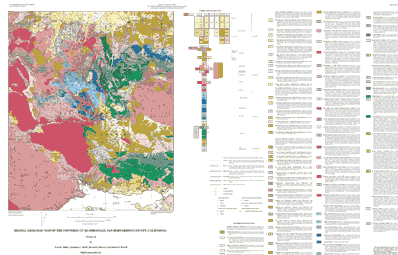
Attribute_Label: LABL
Attribute_Definition:
Geologic map unit label. Plain text is substituted for conventional geologic age symbols (C for Cambrian, Mz for Mesozoic, Tr for Triassic, P for Pennsylvanian, and Pr for Proterozoic) and unit label subscripts as annotated on map
Attribute_Domain_Values:
Enumerated_Domain:
Enumerated_Domain_Value: Qaf
Enumerated_Domain_Value_Definition: Artificial Fill (late Holocene)
Attribute_Domain_Values:
Enumerated_Domain:
Enumerated_Domain_Value: Qw
Enumerated_Domain_Value_Definition: Active-wash deposits (late Holocene)
Attribute_Domain_Values:
Enumerated_Domain:
Enumerated_Domain_Value: Qf
Enumerated_Domain_Value_Definition: Deposits of alluvial fans (late Holocene)
Attribute_Domain_Values:
Enumerated_Domain:
Enumerated_Domain_Value: Qa
Enumerated_Domain_Value_Definition: Deposits of axial valley floors (late Holocene)
Attribute_Domain_Values:
Enumerated_Domain:
Enumerated_Domain_Value: Qc
Enumerated_Domain_Value_Definition: Colluvial deposits (late Holocene)
Attribute_Domain_Values:
Enumerated_Domain:
Enumerated_Domain_Value: Qt
Enumerated_Domain_Value_Definition: Talus deposits (late Holocene)
Attribute_Domain_Values:
Enumerated_Domain:
Enumerated_Domain_Value: Qls
Enumerated_Domain_Value_Definition: Landslide deposits (late Holocene)
Attribute_Domain_Values:
Enumerated_Domain:
Enumerated_Domain_Value: Qs
Enumerated_Domain_Value_Definition: Undifferentiated alluvial deposits (late Holocene)
Attribute_Domain_Values:
Enumerated_Domain:
Enumerated_Domain_Value: Qyf
Enumerated_Domain_Value_Definition: Young deposits of alluvial fans (Holocene and late Pleistocene)
Attribute_Domain_Values:
Enumerated_Domain:
Enumerated_Domain_Value: Qyf5
Enumerated_Domain_Value_Definition: Young deposits of alluvial fans, unit 5 (late Holocene)
Attribute_Domain_Values:
Enumerated_Domain:
Enumerated_Domain_Value: Qyf4
Enumerated_Domain_Value_Definition: Young deposits of alluvial fans, unit 4 (late Holocene)
Attribute_Domain_Values:
Enumerated_Domain:
Enumerated_Domain_Value: Qyf3
Enumerated_Domain_Value_Definition:
Young deposits of alluvial fans, unit 3 (late and middle Holocene)
Attribute_Domain_Values:
Enumerated_Domain:
Enumerated_Domain_Value: Qyf2
Enumerated_Domain_Value_Definition: Young deposits of alluvial fans, unit 2 (early Holocene)
Attribute_Domain_Values:
Enumerated_Domain:
Enumerated_Domain_Value: Qyf1
Enumerated_Domain_Value_Definition:
Young deposits of alluvial fans, unit 1 (early Holocene and late Pleistocene)
Attribute_Domain_Values:
Enumerated_Domain:
Enumerated_Domain_Value: Qya
Enumerated_Domain_Value_Definition:
Young deposits of axial valley floors (Holocene and late Pleistocene)
Attribute_Domain_Values:
Enumerated_Domain:
Enumerated_Domain_Value: Qyc
Enumerated_Domain_Value_Definition: Young colluvial deposits (Holocene and late Pleistocene)
Attribute_Domain_Values:
Enumerated_Domain:
Enumerated_Domain_Value: Qyt
Enumerated_Domain_Value_Definition: Young talus deposits (Holocene and late Pleistocene)
Attribute_Domain_Values:
Enumerated_Domain:
Enumerated_Domain_Value: Qyls
Enumerated_Domain_Value_Definition: Young landslide deposits (Holocene and late Pleistocene)
Attribute_Domain_Values:
Enumerated_Domain:
Enumerated_Domain_Value: Qys
Enumerated_Domain_Value_Definition:
Young surficial deposits undifferentiated (Holocene and late Pleistocene)
Attribute_Domain_Values:
Enumerated_Domain:
Enumerated_Domain_Value: Qof
Enumerated_Domain_Value_Definition: Old deposits of alluvial fans (late to middle Pleistocene)
Attribute_Domain_Values:
Enumerated_Domain:
Enumerated_Domain_Value: Qof3
Enumerated_Domain_Value_Definition: Old deposits of alluvial fans, unit 3 (late Pleistocene)
Attribute_Domain_Values:
Enumerated_Domain:
Enumerated_Domain_Value: Qof2
Enumerated_Domain_Value_Definition: Old deposits of alluvial fans, unit 2 (late Pleistocene)
Attribute_Domain_Values:
Enumerated_Domain:
Enumerated_Domain_Value: Qoa
Enumerated_Domain_Value_Definition:
Old deposits of allvial-valley floors, undifferentiated (late to middle Pleistocene)
Attribute_Domain_Values:
Enumerated_Domain:
Enumerated_Domain_Value: Qot
Enumerated_Domain_Value_Definition: Old talus deposits (late to middle Pleistocene)
Attribute_Domain_Values:
Enumerated_Domain:
Enumerated_Domain_Value: Qols
Enumerated_Domain_Value_Definition: Old landslide deposits (late to middle Pleistocene)
Attribute_Domain_Values:
Enumerated_Domain:
Enumerated_Domain_Value: Qos
Enumerated_Domain_Value_Definition:
Old surficial deposits undifferentiated (late to middle Pleistocene)
Attribute_Domain_Values:
Enumerated_Domain:
Enumerated_Domain_Value: Qvof
Enumerated_Domain_Value_Definition:
Very old deposits of alluvial fans (middle to early Pleistocene)
Attribute_Domain_Values:
Enumerated_Domain:
Enumerated_Domain_Value: Qvof3
Enumerated_Domain_Value_Definition: Very old deposits of alluvial fans, unit 3 (early Pleistocene)
Attribute_Domain_Values:
Enumerated_Domain:
Enumerated_Domain_Value: Qvof2
Enumerated_Domain_Value_Definition: Very old deposits of alluvial fans, unit 2 (early Pleistocene)
Attribute_Domain_Values:
Enumerated_Domain:
Enumerated_Domain_Value: Qvols
Enumerated_Domain_Value_Definition: Very old landslide deposits (middle to early Pleistocene)
Attribute_Domain_Values:
Enumerated_Domain:
Enumerated_Domain_Value: Qvos
Enumerated_Domain_Value_Definition:
Very old surficial deposits, undifferentiated (late to middle Pleistocene)
Attribute_Domain_Values:
Enumerated_Domain:
Enumerated_Domain_Value: Qvobc
Enumerated_Domain_Value_Definition:
Very old deposits of catastrophic carbonate breccia (early Pleistocene)
Attribute_Domain_Values:
Enumerated_Domain:
Enumerated_Domain_Value: Qvobg
Enumerated_Domain_Value_Definition:
Very old deposits of catastrophic granitic breccia (early Pleistocene)
Attribute_Domain_Values:
Enumerated_Domain:
Enumerated_Domain_Value: QTcp
Enumerated_Domain_Value_Definition:
Conglomerate, porphyry-bearing facies (Pleistocene? and Pliocene?)
Attribute_Domain_Values:
Enumerated_Domain:
Enumerated_Domain_Value: QTcc
Enumerated_Domain_Value_Definition: Conglomerate, Cushenberry facies (Pleistocene? and Pliocene?)
Attribute_Domain_Values:
Enumerated_Domain:
Enumerated_Domain_Value: QTsc
Enumerated_Domain_Value_Definition: Sandstone and conglomerate (Pleistocene? and Pliocene?)
Attribute_Domain_Values:
Enumerated_Domain:
Enumerated_Domain_Value: QTscp
Enumerated_Domain_Value_Definition:
Sandstone and conglomerate, porphyry facies (Pleistocene? and Pliocene?)
Attribute_Domain_Values:
Enumerated_Domain:
Enumerated_Domain_Value: QTscc
Enumerated_Domain_Value_Definition:
Sandstone and conglomerate, Cushenberry facies (Pleistocene? and Pliocene?)
Attribute_Domain_Values:
Enumerated_Domain:
Enumerated_Domain_Value: QTom
Enumerated_Domain_Value_Definition:
Old Woman Sandstone, mudrock and sandstone member (Pleistocene? and Pliocene?)
Attribute_Domain_Values:
Enumerated_Domain:
Enumerated_Domain_Value: QTos
Enumerated_Domain_Value_Definition:
Old Woman Sandstone, sandstone memeber (Pleistocene? and Pliocene?)
Attribute_Domain_Values:
Enumerated_Domain:
Enumerated_Domain_Value: Ts4
Enumerated_Domain_Value_Definition: Sedimentary rocks south of Big Bear Lake (Miocene?)
Attribute_Domain_Values:
Enumerated_Domain:
Enumerated_Domain_Value: Ts3
Enumerated_Domain_Value_Definition:
Sedimentary rocks south of Bertha Ridge and John Bull Mountain (Miocene?)
Attribute_Domain_Values:
Enumerated_Domain:
Enumerated_Domain_Value: Ts2
Enumerated_Domain_Value_Definition: Sedimentary rocks of Poligue Canyon (Miocene?)
Attribute_Domain_Values:
Enumerated_Domain:
Enumerated_Domain_Value: Ts1
Enumerated_Domain_Value_Definition: Sedimentary rocks of Holocomb Valley (Miocene?)
Attribute_Domain_Values:
Enumerated_Domain:
Enumerated_Domain_Value: Ts
Enumerated_Domain_Value_Definition: Sandstone (Miocene?)
Attribute_Domain_Values:
Enumerated_Domain:
Enumerated_Domain_Value: Mzu
Enumerated_Domain_Value_Definition:
Undivided granitic rocks of range front (Cretaceous to Jurassic)
Attribute_Domain_Values:
Enumerated_Domain:
Enumerated_Domain_Value: Kbm
Enumerated_Domain_Value_Definition: Biotite monzogranite (Cretaceous)
Attribute_Domain_Values:
Enumerated_Domain:
Enumerated_Domain_Value: Kb
Enumerated_Domain_Value_Definition: Monzogranite of John Bull Flat (Cretaceous)
Attribute_Domain_Values:
Enumerated_Domain:
Enumerated_Domain_Value: Ks
Enumerated_Domain_Value_Definition: Monzogranite of Stanfield Cutoff (Cretaceous)
Attribute_Domain_Values:
Enumerated_Domain:
Enumerated_Domain_Value: Kbp
Enumerated_Domain_Value_Definition: Monzogranite of Butler Peak (Cretaceous)
Attribute_Domain_Values:
Enumerated_Domain:
Enumerated_Domain_Value: Kk
Enumerated_Domain_Value_Definition: Monzogranite of Keller Peak (Cretaceous)
Attribute_Domain_Values:
Enumerated_Domain:
Enumerated_Domain_Value: Kh
Enumerated_Domain_Value_Definition: Granodiorite of Hanna Flat (Cretaceous)
Attribute_Domain_Values:
Enumerated_Domain:
Enumerated_Domain_Value: Kgc
Enumerated_Domain_Value_Definition: Monzogranite of Greenlead Creek (Creteacous)
Attribute_Domain_Values:
Enumerated_Domain:
Enumerated_Domain_Value: KJb
Enumerated_Domain_Value_Definition: Granodiorite of Bousic Canyon (Cretaceous or Jurassic)
Attribute_Domain_Values:
Enumerated_Domain:
Enumerated_Domain_Value: KJdg
Enumerated_Domain_Value_Definition: Mafic mafic diorite and gabbro (Cretaceous or Jurassic)
Attribute_Domain_Values:
Enumerated_Domain:
Enumerated_Domain_Value: KJl
Enumerated_Domain_Value_Definition: Leucocratic granitic rocks (Cretaceous to Jurassic)
Attribute_Domain_Values:
Enumerated_Domain:
Enumerated_Domain_Value: Jh
Enumerated_Domain_Value_Definition:
Volcanic and hypabyssal rocks of Holcomb Valley area (Jurassic?)
Attribute_Domain_Values:
Enumerated_Domain:
Enumerated_Domain_Value: Jcr
Enumerated_Domain_Value_Definition: Cataclastic rocks (Jurassic)
Attribute_Domain_Values:
Enumerated_Domain:
Enumerated_Domain_Value: Jb
Enumerated_Domain_Value_Definition: Bertha Peak Pluton of Cameron (1981) (Jurassic)
Attribute_Domain_Values:
Enumerated_Domain:
Enumerated_Domain_Value: Jfc
Enumerated_Domain_Value_Definition: Quartz monzonite porphyry of Furnace Canyon Jurassic)
Attribute_Domain_Values:
Enumerated_Domain:
Enumerated_Domain_Value: Jc
Enumerated_Domain_Value_Definition: Leucocratic quartz monzonite of Crystal Creek (Jurassic)
Attribute_Domain_Values:
Enumerated_Domain:
Enumerated_Domain_Value: Jd
Enumerated_Domain_Value_Definition: Quartz monzodiorite of Dry Canyon (Jurassic)
Attribute_Domain_Values:
Enumerated_Domain:
Enumerated_Domain_Value: Jdm
Enumerated_Domain_Value_Definition: Deformed monzogranite of hill 4970 (Jurassic)
Attribute_Domain_Values:
Enumerated_Domain:
Enumerated_Domain_Value: Jsc
Enumerated_Domain_Value_Definition: Fine-grained rocks of Silver Canyon (Jurassic)
Attribute_Domain_Values:
Enumerated_Domain:
Enumerated_Domain_Value: Trf
Enumerated_Domain_Value_Definition: Monzonite of Fawnskin (Triassic)
Attribute_Domain_Values:
Enumerated_Domain:
Enumerated_Domain_Value: Pbuc
Enumerated_Domain_Value_Definition: Bird Spring Formation, upper carbonate member (Pennsylvanian)
Attribute_Domain_Values:
Enumerated_Domain:
Enumerated_Domain_Value: Pbmc
Enumerated_Domain_Value_Definition: Bird Spring Formation, middle carbonate member (Pennsylvanian)
Attribute_Domain_Values:
Enumerated_Domain:
Enumerated_Domain_Value: Pblc
Enumerated_Domain_Value_Definition: Bird Spring Formation, lower carbonate member (Pennsylvanian)
Attribute_Domain_Values:
Enumerated_Domain:
Enumerated_Domain_Value: Pbsc
Enumerated_Domain_Value_Definition:
Bird Spring Formation, siltstone and carbonate Member (Pennsylvanian)
Attribute_Domain_Values:
Enumerated_Domain:
Enumerated_Domain_Value: Pbq
Enumerated_Domain_Value_Definition: Bird Spring Formation, quartzite member (Pennsylvanian)
Attribute_Domain_Values:
Enumerated_Domain:
Enumerated_Domain_Value: Mmy
Enumerated_Domain_Value_Definition: Monte Cristo Limestone, Yellowpine Member (Mississippian)
Attribute_Domain_Values:
Enumerated_Domain:
Enumerated_Domain_Value: Mmb
Enumerated_Domain_Value_Definition: Monte Cristo Limestone, Bullion Member (Mississippian)
Attribute_Domain_Values:
Enumerated_Domain:
Enumerated_Domain_Value: Mml
Enumerated_Domain_Value_Definition: Monte Cristo Limestone, lower member (Mississippian)
Attribute_Domain_Values:
Enumerated_Domain:
Enumerated_Domain_Value: Dsc
Enumerated_Domain_Value_Definition: Sultan Limestone, Crystal Pass Member (Devonian)
Attribute_Domain_Values:
Enumerated_Domain:
Enumerated_Domain_Value: Dsv
Enumerated_Domain_Value_Definition: Sultan Limestone, Valentine Member (Devonian)
Attribute_Domain_Values:
Enumerated_Domain:
Enumerated_Domain_Value: Dsi
Enumerated_Domain_Value_Definition: Sultan Limestone, Ironside Member (Devonian)
Attribute_Domain_Values:
Enumerated_Domain:
Enumerated_Domain_Value: Cn
Enumerated_Domain_Value_Definition: Nopah Formation (Cambrian)
Attribute_Domain_Values:
Enumerated_Domain:
Enumerated_Domain_Value: Cnd
Enumerated_Domain_Value_Definition: Dunderburg Shale Member (Cambrian)
Attribute_Domain_Values:
Enumerated_Domain:
Enumerated_Domain_Value: Cb
Enumerated_Domain_Value_Definition: Bonanza King Formation, undivided (Cambrian)
Attribute_Domain_Values:
Enumerated_Domain:
Enumerated_Domain_Value: Cba
Enumerated_Domain_Value_Definition: Bonanza King Formation, argillaceous marker unit (Cambrian)
Attribute_Domain_Values:
Enumerated_Domain:
Enumerated_Domain_Value: Cbdg
Enumerated_Domain_Value_Definition: Bonanza King Formation, gray dolomite member (Cambrian)
Attribute_Domain_Values:
Enumerated_Domain:
Enumerated_Domain_Value: Cbdw
Enumerated_Domain_Value_Definition: Bonanza King Formation, white dolomite member (Cambrian)
Attribute_Domain_Values:
Enumerated_Domain:
Enumerated_Domain_Value: Cbm
Enumerated_Domain_Value_Definition: Bonanza King Formation, middle member (Cambrian)
Attribute_Domain_Values:
Enumerated_Domain:
Enumerated_Domain_Value: Cbl
Enumerated_Domain_Value_Definition: Bonanza King Formation, lower member (Cambrian)
Attribute_Domain_Values:
Enumerated_Domain:
Enumerated_Domain_Value: Cc
Enumerated_Domain_Value_Definition: Carrara Formation (Cambrian)
Attribute_Domain_Values:
Enumerated_Domain:
Enumerated_Domain_Value: Cz
Enumerated_Domain_Value_Definition: Zabriskie Quartzite (Cambrain)
Attribute_Domain_Values:
Enumerated_Domain:
Enumerated_Domain_Value: Cw
Enumerated_Domain_Value_Definition: Wood Canyon Formation (Cambrian)
Attribute_Domain_Values:
Enumerated_Domain:
Enumerated_Domain_Value: Prsq
Enumerated_Domain_Value_Definition: Stirling Quartzite, quartzite member (late Proterozoic)
Attribute_Domain_Values:
Enumerated_Domain:
Enumerated_Domain_Value: Prscq
Enumerated_Domain_Value_Definition:
Stirling Quartzite, carbonate and quartzite member (late Proterozoic)
Attribute:
Attribute_Label: SHDFIL
Attribute_Definition:
Coded integer value that relates polygon to fill pattern in shadeset, geology2.shd.
Attribute:
Attribute_Label: PLABL
Attribute_Definition: Coded geologic map unit label used to generate plot label.
Attribute:
Attribute_Label: NAME
Attribute_Definition: Geologic name of map unit (see list under LABL attribute).
Attribute:
Attribute_Label: TAG
Attribute_Definition:
A reference label for subgroups of polygons of the geologic-map unit identified by LABL. Each polygon subgroup has certain attributes in common with all other polygons of the map unit. However, each subgroup may have unique, distinguishing attributes which warrant recognition in the database although those distinguishing characteristics do not warrant recognition as new map units.
TAG is defined as LABL followed by an upper-case letter, e.g., QwA, QwB, or QwC, etc. There are many units in the Fawnskin quadrangle that have sufficiently distinctive properties that are identified with TAG other than the dafault A designation.
TAG serves one additional purpose: it functions as the relate item that associates each polygon with its attributes stored in the six polygon-attribute data tables identified in the Entity_and_Attribute_Overview section above.
Attribute:
Attribute_Label: SHDPS
Attribute_Definition:
Polygon color from shadeset scamp2.shd (included in the data package) and used to generate the map plotfile.
Attribute:
Attribute_Label: POLYCON
Attribute_Definition:
Coded statement of confidence with which the unit assignment was made (See Entity_and_Attribute_Detail_Citation section).
Detailed_Description:
Entity_Type:
Entity_Type_Label: FSKN_GEO.AAT
Entity_Type_Definition: Geologic contacts and faults that bound rock-unit polygons.
Attribute:
Attribute_Label: L-SYMB
Attribute_Definition:
Coded integer symbol that relates arc to cartographic line symbol in lineset, geoscamp2.lin.
Attribute:
Attribute_Label: L-TAG
Attribute_Definition:
Coded alpha-numerical symbol that relates arc to definition of line type in dictionary, lines.rel. For description of attributes in line classification dictionary, refer to USGS Open-File Report 97-861 (see Entity_and_Attribute_Detail_Citation)
Attribute_Domain_Values:
Enumerated_Domain:
Enumerated_Domain_Value: C1
Enumerated_Domain_Value_Definition: Contact, generic, location meets map accuracy standards
Attribute_Domain_Values:
Enumerated_Domain:
Enumerated_Domain_Value: C18
Enumerated_Domain_Value_Definition:
Contact, landslide, location may not meet map accuracy standards
Attribute_Domain_Values:
Enumerated_Domain:
Enumerated_Domain_Value: C19
Enumerated_Domain_Value_Definition:
Contact, landslide, inferred, location may not meet map accuracy standards
Attribute_Domain_Values:
Enumerated_Domain:
Enumerated_Domain_Value: C25
Enumerated_Domain_Value_Definition:
Contact, landslide crown scarp, location meets map accuracy standards
Attribute_Domain_Values:
Enumerated_Domain:
Enumerated_Domain_Value: C26
Enumerated_Domain_Value_Definition:
Contact, landslide crown scarp, location may not meet map accuracy standards
Attribute_Domain_Values:
Enumerated_Domain:
Enumerated_Domain_Value: C29
Enumerated_Domain_Value_Definition: Contact, sedimentary, location may meet map accuracy standards
Attribute_Domain_Values:
Enumerated_Domain:
Enumerated_Domain_Value: C30
Enumerated_Domain_Value_Definition:
Contact, sedimentary, location may not meet map accuracy standards
Attribute_Domain_Values:
Enumerated_Domain:
Enumerated_Domain_Value: C32
Enumerated_Domain_Value_Definition: Contact, sedimentary, inferred beneath mapped covering unit
Attribute_Domain_Values:
Enumerated_Domain:
Enumerated_Domain_Value: C37
Enumerated_Domain_Value_Definition:
Contact, separates terraced alluvial units, location meets map accuracy standards
Attribute_Domain_Values:
Enumerated_Domain:
Enumerated_Domain_Value: C38
Enumerated_Domain_Value_Definition:
Contact, separates terraced alluvial units, location may not meet map accuracy standards
Attribute_Domain_Values:
Enumerated_Domain:
Enumerated_Domain_Value: C49
Enumerated_Domain_Value_Definition: Contact, igneous, location meets map accuracy standards
Attribute_Domain_Values:
Enumerated_Domain:
Enumerated_Domain_Value: C50
Enumerated_Domain_Value_Definition: Contact, igneous, location may not meet map accuracy standards
Attribute_Domain_Values:
Enumerated_Domain:
Enumerated_Domain_Value: C51
Enumerated_Domain_Value_Definition:
Contact, igneous, inferred, location meets map accuracy standards
Attribute_Domain_Values:
Enumerated_Domain:
Enumerated_Domain_Value: CL1
Enumerated_Domain_Value_Definition: Cartographic line, map boundary
Attribute_Domain_Values:
Enumerated_Domain:
Enumerated_Domain_Value: F1
Enumerated_Domain_Value_Definition:
Fault, high-angle, slip unspecified, location meets map accuracy standards
Attribute_Domain_Values:
Enumerated_Domain:
Enumerated_Domain_Value: F10
Enumerated_Domain_Value_Definition:
Fault, high-angle, normal slip, location may not meet map accuracy standards
Attribute_Domain_Values:
Enumerated_Domain:
Enumerated_Domain_Value: F162
Enumerated_Domain_Value_Definition:
Fault, low-angle, thrust slip, older over younger, location meets map accuracy standards
Attribute_Domain_Values:
Enumerated_Domain:
Enumerated_Domain_Value: F177
Enumerated_Domain_Value_Definition:
Fault, low-angle, thrust slip, older over younger, location meets map accuracy standards
Attribute_Domain_Values:
Enumerated_Domain:
Enumerated_Domain_Value: F178
Enumerated_Domain_Value_Definition:
Fault, low-angle, thrust slip, older over younger, location may not meet map accuracy standards
Attribute_Domain_Values:
Enumerated_Domain:
Enumerated_Domain_Value: F180
Enumerated_Domain_Value_Definition:
Fault, low-angle, thrust slip, older over younger, inferred beneath mapped covering unit
Attribute_Domain_Values:
Enumerated_Domain:
Enumerated_Domain_Value: F19
Enumerated_Domain_Value_Definition:
Fault, high-angle, slip unspecified, inferred beneath mapped covering unit
Attribute_Domain_Values:
Enumerated_Domain:
Enumerated_Domain_Value: F193
Enumerated_Domain_Value_Definition:
Fault, low-angle, thrust slip, older over younger, has fault scarp, location meets map accuracy standards
Attribute_Domain_Values:
Enumerated_Domain:
Enumerated_Domain_Value: F2
Enumerated_Domain_Value_Definition:
Fault, high-angle, right-lateral strike-slip, location meets map accuracy standards
Attribute_Domain_Values:
Enumerated_Domain:
Enumerated_Domain_Value: F20
Enumerated_Domain_Value_Definition:
Fault, high-angle, right-lateral strike-slip, inferred beneath mapped covering unit
Attribute_Domain_Values:
Enumerated_Domain:
Enumerated_Domain_Value: F205
Enumerated_Domain_Value_Definition:
Fault, variable angle dip, rotational normal slip, location meets map accuracy standards
Attribute_Domain_Values:
Enumerated_Domain:
Enumerated_Domain_Value: F206
Enumerated_Domain_Value_Definition:
Fault, variable angle dip, rotational normal slip, location may not meet map accuracy standards
Attribute_Domain_Values:
Enumerated_Domain:
Enumerated_Domain_Value: F208
Enumerated_Domain_Value_Definition:
Fault, variable angle dip, rotational normal slip, inferred beneath mapped covering unit
Attribute_Domain_Values:
Enumerated_Domain:
Enumerated_Domain_Value: F22
Enumerated_Domain_Value_Definition:
Fault, high-angle, normal slip, inferred beneath mapped covering unit
Attribute_Domain_Values:
Enumerated_Domain:
Enumerated_Domain_Value: F220
Enumerated_Domain_Value_Definition: Fault, intruded, preintrusive existence inferred
Attribute_Domain_Values:
Enumerated_Domain:
Enumerated_Domain_Value: F4
Enumerated_Domain_Value_Definition:
Fault, high-angle, normal slip, location meets map accuracy standards
Attribute_Domain_Values:
Enumerated_Domain:
Enumerated_Domain_Value: F5
Enumerated_Domain_Value_Definition:
Fault, high-angle, reverse slip, location meets map accuracy standards
Attribute_Domain_Values:
Enumerated_Domain:
Enumerated_Domain_Value: F53
Enumerated_Domain_Value_Definition:
Fault, high-angle, reverse slip, has fault scarp, location meets map accuracy standards
Attribute_Domain_Values:
Enumerated_Domain:
Enumerated_Domain_Value: F7
Enumerated_Domain_Value_Definition:
Fault, high-angle, slip unspecified, location may not meet map accuracy standards
Attribute_Domain_Values:
Enumerated_Domain:
Enumerated_Domain_Value: FZ1
Enumerated_Domain_Value_Definition: Fault zone boundary, scratch contact
Attribute_Domain_Values:
Enumerated_Domain:
Enumerated_Domain_Value: FZ3
Enumerated_Domain_Value_Definition: Cataclastic zone boundary, scratch contact
Attribute_Domain_Values:
Enumerated_Domain:
Enumerated_Domain_Value: GF10
Enumerated_Domain_Value_Definition: Geomorphic feature, lakeshore
Attribute_Domain_Values:
Enumerated_Domain:
Enumerated_Domain_Value: GF7
Enumerated_Domain_Value_Definition: Geomorphic feature, topographic scarp, origin unknown
Attribute:
Attribute_Label: L-NAME
Attribute_Definition: Formal name of linear geologic feature.
Detailed_Description:
Entity_Type:
Entity_Type_Label: FSKN_PTS.PAT
Entity_Type_Definition: Structural point data.
Attribute:
Attribute_Label: P-DIP
Attribute_Definition: Dip of planar feature.
Attribute:
Attribute_Label: P-STRIKE
Attribute_Definition: Azimuthal strike of planar feature.
Attribute:
Attribute_Label: P-SYMB
Attribute_Definition:
Coded integer symbol that relates point to cartographic point symbol in markerset, geoscamp2.mrk.
Attribute:
Attribute_Label: P-TAG
Attribute_Definition:
Coded alpha-numerical symbol that relates point to definition of point type in dictionary look-up table (points.rel). For description of attributes in point classification dictionary, refer to USGS Open-File Report 97-859 (see Entity_and_Attribute_Detail_Citation).
Attribute_Domain_Values:
Enumerated_Domain:
Enumerated_Domain_Value: B2
Enumerated_Domain_Value_Definition: Bedding attitude, sedimentary, inclined
Attribute_Domain_Values:
Enumerated_Domain:
Enumerated_Domain_Value: B4
Enumerated_Domain_Value_Definition: Bedding attitude, sedimentary, vertical
Attribute_Domain_Values:
Enumerated_Domain:
Enumerated_Domain_Value: B6
Enumerated_Domain_Value_Definition: Bedding attitude, sedimentary, overturned
Attribute_Domain_Values:
Enumerated_Domain:
Enumerated_Domain_Value: FN13
Enumerated_Domain_Value_Definition: Foliation attitude, igneous flow origin, inclined
Attribute_Domain_Values:
Enumerated_Domain:
Enumerated_Domain_Value: FN31
Enumerated_Domain_Value_Definition: Foliation attitude, strain dominated origin, inclined
Attribute_Domain_Values:
Enumerated_Domain:
Enumerated_Domain_Value: FN42
Enumerated_Domain_Value_Definition: Foliation attitude, metamorphic origin, inclined
Attribute_Domain_Values:
Enumerated_Domain:
Enumerated_Domain_Value: FN43
Enumerated_Domain_Value_Definition: Foliation attitude, metamorphic origin, vertical
Attribute_Domain_Values:
Enumerated_Domain:
Enumerated_Domain_Value: L16
Enumerated_Domain_Value_Definition: Lineation attitude, crushed and streaked mineral grains
Attribute:
Attribute_Label: P-DIPDIR
Attribute_Definition: Azimuthal direction of dip of planar feature.
Attribute:
Attribute_Label: P-PLUNGE
Attribute_Definition: Plunge of linear feature.
Attribute:
Attribute_Label: P-BEARING
Attribute_Definition: Azimuthal direction of plunge of linear feature.
Detailed_Description:
Entity_Type:
Entity_Type_Label: FSKN_STR.AAT
Entity_Type_Definition: Linear, structural features e.g. fold axes.
Attribute:
Attribute_Label: L-SYMB
Attribute_Definition:
Stores appropriate line symbol value from the lineset geoscamp2.lin.
Attribute:
Attribute_Label: L-TAG
Attribute_Definition:
Coded alpha-numerical symbol that relates arc to definition of line type in dictionary, lines.rel. For description of attributes in line classification dictionary, refer to USGS Open-File Report 97-861 (see Entity_and_Attribute_Detail_Citation).
Attribute_Domain_Values:
Enumerated_Domain:
Enumerated_Domain_Value: FA33
Enumerated_Domain_Value_Definition:
Fold axial trace, anticline, upright, subhorizontal plunge, location meets map accuracy standards
Attribute_Domain_Values:
Enumerated_Domain:
Enumerated_Domain_Value: FA36
Enumerated_Domain_Value_Definition:
Fold axial trace, anticline, upright, subhorizontal plunge, inferred beneath mapped covering unit
Attribute_Domain_Values:
Enumerated_Domain:
Enumerated_Domain_Value: FA49
Enumerated_Domain_Value_Definition:
Fold axial trace, anticline, overturned, subhorizontal plunge, location meets map accuracy standards
Attribute_Domain_Values:
Enumerated_Domain:
Enumerated_Domain_Value: FA97
Enumerated_Domain_Value_Definition:
Fold axial trace, syncline, upright, subhorizontal plunge, location meets map accuracy standards
Attribute_Domain_Values:
Enumerated_Domain:
Enumerated_Domain_Value: FA100
Enumerated_Domain_Value_Definition:
Fold axial trace, syncline, upright, subhorizontal plunge, inferred beneath mapped covering unit
Attribute_Domain_Values:
Enumerated_Domain:
Enumerated_Domain_Value: FA113
Enumerated_Domain_Value_Definition:
Fold axial trace, syncline, overturned, subhorizontal plunge, location meets map accuracy standards
Detailed_Description:
Entity_Type:
Entity_Type_Label: FSKN_ORN.PAT
Entity_Type_Definition: Line ornamentation.
Attribute:
Attribute_Label: P-SYMB
Attribute_Definition:
Coded integer symbol that relates point to cartographic point symbol in markerset, geoscamp2.mrk.
Attribute:
Attribute_Label: P-TAG
Attribute_Definition:
Coded alpha-numerical symbol that relates point to definition of point type in dictionary INFO table, points.rel. For description of attributes in point classification dictionary, refer to USGS Open-File Report 97-859 (see Entity_and_Attribute_Detail_Citation).
Attribute_Domain_Values:
Enumerated_Domain:
Enumerated_Domain_Value: FAC10
Enumerated_Domain_Value_Definition: Fold ornament, syncline, upright axial plane
Attribute_Domain_Values:
Enumerated_Domain:
Enumerated_Domain_Value: FAC12
Enumerated_Domain_Value_Definition: Fold ornament, anticline, overturned axial plane
Attribute_Domain_Values:
Enumerated_Domain:
Enumerated_Domain_Value: FAC4
Enumerated_Domain_Value_Definition: Fold ornament, anticline, upright axial plane
Attribute_Domain_Values:
Enumerated_Domain:
Enumerated_Domain_Value: FAC6
Enumerated_Domain_Value_Definition: Fold ornament, anticline, overturned axial plane
Detailed_Description:
Entity_Type:
Entity_Type_Label: FSKN_LDR.AAT
Entity_Type_Definition: Annotation leaders.
Attribute:
Attribute_Label: L-SYMB
Attribute_Definition:
Coded integer symbol, value 1, that relates arcs to cartographic line symbol in lineset, geoscamp2.lin.
Distribution_Information:
Distributor:
Contact_Information:
Contact_Organization_Primary:
Contact_Organization: U.S. Geological Survey Information Services
Contact_Address:
Address_Type: mailing
Address: Box 25286, Denver Federal Center
City: Denver
State_or_Province: Colorado
Postal_Code: 80255-0046
Country: USA
Contact_Voice_Telephone: 1-888-ASK-USGS
Contact_Voice_Telephone: 303-202-4700
Contact_Facsimile_Telephone: 303-202-4693
Resource_Description: US Geological Survey Open-File Report 98-0579
Distribution_Liability:
The U.S. Geological Survey (USGS) provides these geographic data "as is." The USGS makes no guarantee or warranty concerning the accuracy of information contained in the geographic data. The USGS further makes no warranties, either expressed or implied as to any other matter whatsoever, including, without limitation, the condition of the product, or its fitness for any particular purpose. The burden for determining fitness for use lies entirely with the user. Although these data have been processed successfully on computers at the USGS, no warranty, expressed or implied, is made by the USGS regarding the use of these data on any other system, nor does the fact of distribution constitute or imply any such warranty.
In no event shall the USGS have any liability whatsoever for payment of any consequential, incidental, indirect, special, or tort damages of any kind, including, but not limited to, any loss of profits arising out of use of or reliance on the geographic data or arising out of delivery, installation, operation, or support by USGS.
This digital, geologic map database of the Fawnskin 7.5'quadrangle, 1:24,000 map-scale, and any derivative maps thereof, is not meant to be used or displayed at any scale larger than 1:24,000 (e.g., 1:12,000).
Standard_Order_Process:
Digital_Form:
Digital_Transfer_Information:
Format_Name: ARCE
Format_Version_Number: 7.1.1
Format_Information_Content: Geologic units, structural features, point measurements
Transfer_Size: 3.5
File_Decompression_Technique: tar and gzip
Digital_Transfer_Option:
Online_Option:
Computer_Contact_Information:
Network_Address:
Fees: none
Metadata_Reference_Information:
Metadata_Date: 20160610
Metadata_Contact:
Contact_Information:
Contact_Person_Primary:
Contact_Person: Peter N Schweitzer
Contact_Organization: USGS Midwest Area
Contact_Position:
Collection manager, USGS Geoscience Data Clearinghouse, http://geo-nsdi.er.usgs.gov/
Contact_Address:
Address_Type: mailing address
Address:
Mail Stop 954
12201 Sunrise Valley Dr
City: Reston
State_or_Province: VA
Postal_Code: 20192-0002
Country: USA
Contact_Voice_Telephone: 703-648-6533
Contact_Facsimile_Telephone: 703-648-6252
Contact_Electronic_Mail_Address: pschweitzer@usgs.gov
Metadata_Standard_Name: Content Standard for Digital Geospatial Metadata
Metadata_Standard_Version: FGDC-STD-001-1998
Metadata_Access_Constraints: None
Metadata_Use_Constraints: None

This page is <https://geo-nsdi.er.usgs.gov/metadata/open-file/98-579/metadata.html>
Generated by mp version 2.9.48 on Tue Jul 03 20:07:12 2018