Geologic map of the Hayward fault zone, Contra Costa, Alameda, and Santa Clara Counties, California: A digital database

Metadata also available as - [Outline] - [Parseable text] - [XML]

Frequently anticipated questions:


What does this data set describe?

Title:
Geologic map of the Hayward fault zone, Contra Costa, Alameda, and Santa Clara Counties, California: A digital database
Abstract:
This digital map database, compiled from previously open- filed U.S. Geological Survey reports (Graymer and others, 1994, Graymer, Jones, and Brabb, 1994) and unpublished data, represents the general distribution of rocks and faults in the Hayward fault zone. As described in this report, the Hayward fault zone is a zone of highly deformed rocks which trends north 30 degrees west from an area southeast of San Jose to the San Pablo Bay, and ranges in width from 2 to 10 kilometers. Although historic earthquake activity has been concentrated in the western part of the zone, the zone as a whole reflects oblique right-lateral and compressive deformation along a significant upper crustal break over the past 10 million years or more. Together with the accompanying text file (hfgeo.txt), the database provides current information on the distribution and description of faults and rock types within the fault zone. In addition, the text file discusses the development of the fault zone in the past 10 million years, the relationship of the Hayward and Calaveras fault zones, and the significance of the creeping strand of the Hayward fault (as most recently defined by Lienkaemper, 1992).
  1. How might this data set be cited?
    Graymer, R.W., Jones, D.L., and Brabb, E.E., 1995, Geologic map of the Hayward fault zone, Contra Costa, Alameda, and Santa Clara Counties, California: A digital database: U.S. Geological Survey Open-File Report 95-597.

    Online Links:

  2. What geographic area does the data set cover?
    West_Bounding_Coordinate: -122.424
    East_Bounding_Coordinate: -121.587
    North_Bounding_Coordinate: 38.021
    South_Bounding_Coordinate: 37.157
  3. What does it look like?
    http://pubs.usgs.gov/of/1995/of95-597/images/hfmap.jpg (JPEG)
    Reduced-size image of geologic map sheet of the Hayward fault zone.
  4. Does the data set describe conditions during a particular time period?
    Calendar_Date: 1995
    Currentness_Reference:
    publication date
  5. What is the general form of this data set?
    Geospatial_Data_Presentation_Form: map
  6. How does the data set represent geographic features?
    1. How are geographic features stored in the data set?
      This is a vector data set.
    2. What coordinate system is used to represent geographic features?
  7. How does the data set describe geographic features?
    HF_UM-FLT.AAT
    Map of faults in the Hayward fault zone (Source: OFR-95-0597)
    LTYPE
    Line type (Source: OFR-95-0597)
    ValueDefinition
    atten. fault, approx. locatedAttenuated fault whose position is not precisely known
    atten. fault, certainObserved attenuated fault
    atten. fault, concealedConcealed attenuated fault whose position is inferred
    fault, approx. locatedFault whose position is not precisely known
    fault, certainObserved fault
    fault, concealedConcealed fault whose position is inferred
    fault, concealed, queriedConcealed fault whose position is questionable
    fault, inferredFault whose position is inferred
    fault, inferred, queriedFault whose position is inferred and questionable
    s.s. fault, r.l., approx. locatedRight-lateral strike-slip fault whose position is not precisely known
    s.s. fault, r.l., certainObserved right-lateral strike-slip fault
    s.s. fault, r.l., concealedConcealed right-lateral strike-slip fault
    thrust fault, approx. locatedThrust fault whose position is not precisely known
    thrust fault, certainObserved thrust fault
    thrust fault, concealedConcealed thrust fault whose position is inferred
    thrust fault, inferredThrust fault whose position is inferred
    DOMAIN
    The subzone that the fault is in (Source: OFR-95-0597)
    ValueDefinition
    Castro Valley 
    Chabot 
    Fremont 
    San Leandro 
    San Pablo 
    creeping 
    east boundary 
    (blank)unknown
    FNAME
    Fault name, if any (Source: OFR-95-0597)
    HFAL_UM.PAT
    Geologic map of the Hayward fault zone in Alameda County (Source: OFR-95-0597)
    PTYPE
    Polygon type (Source: OFR-95-0597)
    ValueDefinition
    JKfmFranciscan melange (Late Jurassic and Early Cretaceous)
    JKfnSandstone of Novato Quarry (Late Cretaceous)
    JKfUndivided rocks of the Franciscan Complex (Late Jurassic to Late Cretaceous)
    spSerpentinite - Coast Range Ophiolite (Jurassic)
    JgbGabbro - Coast Range Ophiolite (Jurassic)
    JbMassive basalt and diabase - Coast Range Ophiolite (Jurassic)
    JpbPillow basalt, basalt breccia, and minor diabase - Coast Range Ophiolite (Jurassic)
    JsvKeratophyre and quartz keratophyre (Late Jurassic)
    JKkKnoxville Formation (Late Jurassic and Early Cretaceous)
    KncSandstone and shale of Niles Canyon (Early Cretaceous, Albian)
    KjmJoaquin Miller Formation (Late Cretaceous, Cenomanian)
    KoOakland Sandstone (Late Cretaceous, Cenomanian and/or Turonian)
    KcvUnnamed sandstone, conglomerate, and shale of the Castro Valley area (Late Cretaceous, Turonian and younger(?))
    KscShephard Creek Formation (Late Cretaceous, Campanian)
    KrRedwood Canyon Formation (Late Cretaceous, Campanian)
    KpPinehurst Shale (Late Cretaceous, Campanian)
    KuUndivided, unnamed sandstone and siltstone (Cretaceous)
    KcUndivided, unnamed conglomerate (Cretaceous)
    TasUnnamed glauconitic sandstone (Paleocene)
    TpsUnnamed siltstone and sandstone (Paleocene)
    TesUnnamed mudstone (Eocene)
    TtlsGray, algal limestone - Tolman Formation of Hall (1958) (Eocene?)
    TtsDark gray to dark greenish-gray, indistinctly bedded, glauconite bearing, medium- to coarse- grained lithic sandstone - Tolman Formation of Hall (1958) (Eocene?)
    TgsUnnamed glauconitic mudstone (Oligocene(?) and Miocene)
    TshUnnamed sandstone, shale, chert, and dolomite (early Miocene)
    TsSobrante Sandstone (middle Miocene)
    TccChert and siliceous shale member - Claremont Formation (middle to late Miocene)
    TcsSandstone and siltstone member - Claremont Formation (middle to late Miocene)
    ToOursan Sandstone (middle to late Miocene)
    TtTice Shale (late Miocene)
    TbrBriones Formation (late Miocene)
    TorOrinda Formation (late Miocene)
    TmMoraga Formation (late Miocene)
    TstSiesta Formation (late Miocene)
    TbpBald Peak Basalt (late Miocene)
    TnNeroly Sandstone (late Miocene)
    TvUnnamed volcanic rocks (late Miocene or early Pliocene)
    TssUnnamed sandstone and conglomerate (Tertiary)
    TskSilver Creek Gravels of Graymer and DeVito (1993) (Pliocene)
    QTpPackwood Gravels of Crittenden (1951) (Pliocene and Pleistocene(?))
    QTlLivermore Gravels (Pliocene and/or Pleistocene)
    QTiIrvington Gravels of Savage (1951) (Pliocene(?) and Pleistocene)
    QoaUnnamed gravels and terrace deposits (Pleistocene)
    QlsLandslide deposits (Pleistocene and/or Holocene)
    QuUndivided surficial deposits (Pleistocene or Holocene)
    QmManmade deposits (Holocene)
    HFAL_UM.PAT
    Geologic map units of the Hayward fault zone in Alameda County at specific locations (same attributes as polygon coverage HFAL_UM.PAT) (Source: OFR-95-0597)
    HFAL_UM.AAT
    Linear geologic features (Source: OFR-95-0597)
    LTYPE
    Line type (Source: OFR-95-0597)
    ValueDefinition
    atten. fault, approx. locatedAttenuated fault whose position is not precisely known
    atten. fault, certainObserved attenuated fault
    atten. fault, concealedConcealed attenuated fault whose position is inferred
    fault, approx. locatedFault whose position is not precisely known
    fault, certainObserved fault
    fault, concealedConcealed fault whose position is inferred
    fault, concealed, queriedConcealed fault whose position is questionable
    fault, inferredFault whose position is inferred
    fault, inferred, queriedFault whose position is inferred and questionable
    s.s. fault, r.l., approx. locatedRight-lateral strike-slip fault whose position is not precisely known
    s.s. fault, r.l., certainObserved right-lateral strike-slip fault
    s.s. fault, r.l., concealedConcealed right-lateral strike-slip fault
    thrust fault, approx. locatedThrust fault whose position is not precisely known
    thrust fault, certainObserved thrust fault
    thrust fault, concealedConcealed thrust fault whose position is inferred
    thrust fault, inferredThrust fault whose position is inferred
    contact, approx. locatedContact whose position is not precisely known
    contact, certainObserved contact
    contact, inferred 
    map boundaryBoundary of mapped area
    scratch boundaryPosition of scratch boundary
    water boundaryBoundary of a body of water
    (blank)unknown
    HFCC_UM.PAT
    Geologic map of the Hayward fault zone in Contra Costra County (same attributes as HFAL_UM.PAT) (Source: OFR-95-0597)
    HFCC_UM.AAT
    Linear geologic features of the Hayward fault zone in Contra Costra County (same attributes as HFAL_UM.AAT) (Source: OFR-95-0597)
    HFCC_UM.PAT
    Geology of the Hayward fault zone in Contra Costra County at specific locations (same attributes as HFAL_UM.PAT) (Source: OFR-95-0597)
    HFSC_UM.PAT
    Geologic map of the Hayward fault zone in Santa Clara County (same attributes as HFAL_UM.PAT) (Source: OFR-95-0597)
    HFSC_UM.PAT
    Geologic map units of the Hayward fault zone in Santa Clara County at specific locations(same attributes as HFAL_UM.PAT) (Source: OFR-95-0597)
    HFSC_UM.AAT
    Linear geologic features of the Hayward fault zone in Santa Clara County (same attributes as HFAL_UM.AAT) (Source: OFR-95-0597)

Who produced the data set?

  1. Who are the originators of the data set? (may include formal authors, digital compilers, and editors)
    • R.W. Graymer
    • D.L. Jones
    • E.E. Brabb
  2. Who also contributed to the data set?
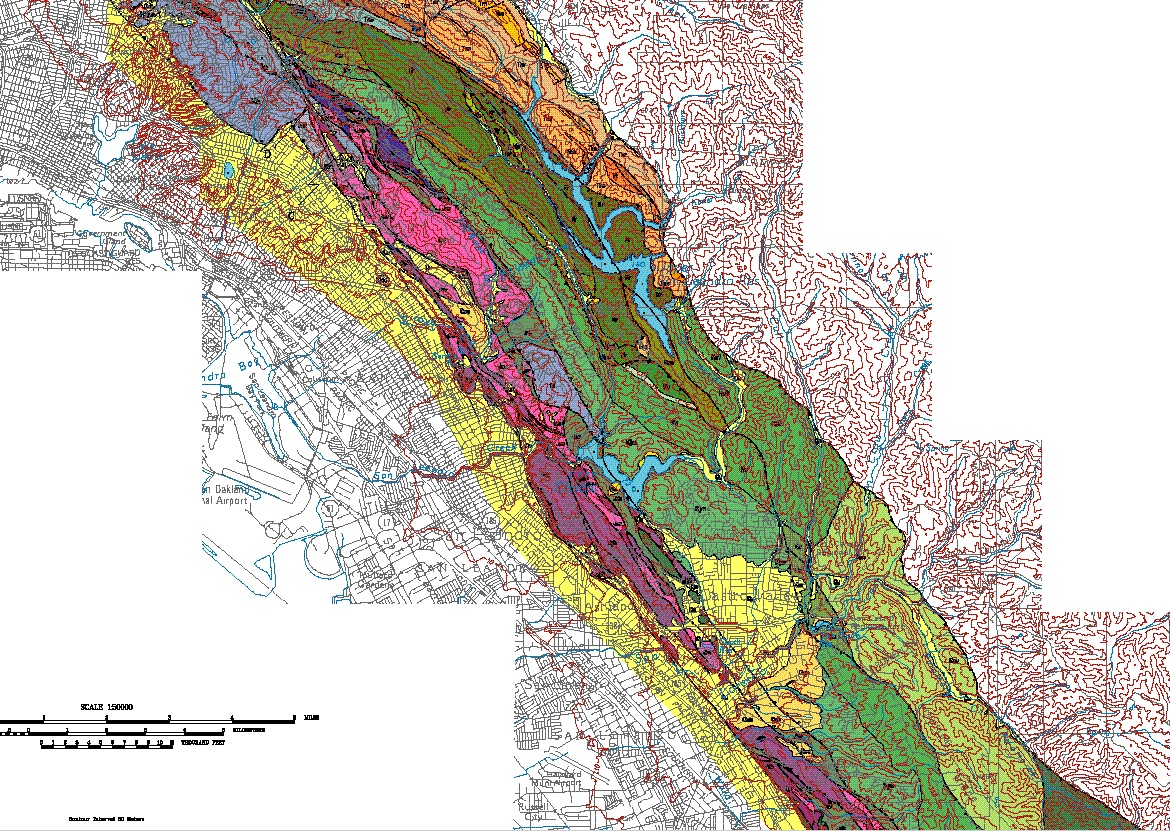
    All of the geologic mapping for the Hayward fault zone is new, but we acknowledge our debt to previous workers who established the geologic framework. Data sources for geologic mapping in the fault zone within Contra Costa County are provided by Graymer, Jones, and Brabb (1994). In Alameda and Santa Clara Counties, the geologic reports by Radbruch (1969), Case (1968), Graymer and others (1994), Robinson (1956), Hall (1958), and Crittenden (1951) are especially relevant. Preliminary geologic maps by T.W. Dibblee of most of the 1:24,000 quadrangles are available in Open-File Reports of the U.S. Geological Survey (see references). The map and report by Lienkaemper (1992) provided some of the lines for the creeping strand of the Hayward fault, and they contain many references to previous work. Several students have done theses in the area; the ones by Haltenhoff (1978), Whiteley (1978), and Prowell (1974) are especially pertinent.
  3. To whom should users address questions about the data?
    Wells, Ray E
    USGS-GEO-WRG-NGM
    Mail Stop 975, USGS
    345 Middlefield Road
    Menlo Park, CA
    US

    650-329-4933 (voice)
    rwells@usgs.gov

Why was the data set created?

The purpose of this report is fivefold. 1) to demonstrate the short history of the creeping strand and to describe the structural history of the fault zone as a whole; 2) to illustrate potentially active strands within the Hayward fault zone in addition to the creeping strand defined by Lienkaemper; 3) to describe structures related to the Hayward fault zone including compressive structures; 4) to show possible Hayward - Calaveras fault connections in addition to that proposed by Andrews and others; 5) to describe rock types involved in the Hayward fault zone.

How was the data set created?

  1. From what previous works were the data drawn?
    Graymer, Jones, and Brabb (1994) (source 1 of 8)
    Graymer, R.W., Jones, D.L., and Brabb, E.E., 1994, Preliminary geologic map emphasizing bedrock formations in Contra Costa County, California: A digital database: U.S. Geological Survey Open-File Report 94-0622.

    Type_of_Source_Media: online
    Source_Contribution: geologic mapping in the fault zone within Contra Costa County
    Radbruch (1969) (source 2 of 8)
    Radbruch, D.H., 1969, Areal and engineering geology of the Oakland East quadrangle, California: U.S. Geological Survey Geologic Quadrangle Map GQ-769.

    Type_of_Source_Media: paper
    Source_Scale_Denominator: 24000
    Source_Contribution:
    geologic mapping in the fault zone within Alameda and Santa Clara Counties
    Case (1968) (source 3 of 8)
    Case, J.E., 1968, Upper Cretaceous and lower Tertiary rocks, Berkeley and San Leandro Hills, California: U.S. Geological Survey Bulletin 1250-J.

    Type_of_Source_Media: paper
    Source_Contribution:
    geologic mapping in the fault zone within Alameda and Santa Clara Counties
    Graymer and others (1994) (source 4 of 8)
    Graymer, R.W., Jones, D.L., Brabb, E.E., and Helley, E.J., 1994, Preliminary geologic map of the Niles 7.5 minute quadrangle, Alameda County, California: U.S. Geological Survey Open-File Report 94-0132.

    Type_of_Source_Media: paper
    Source_Scale_Denominator: 24000
    Source_Contribution:
    geologic mapping in the fault zone within Alameda and Santa Clara Counties
    Robinson (1956) (source 5 of 8)
    Robinson, G.D., 1956, Geology of the Hayward quadrangle, California: U.S. Geological Survey Miscellaneous Investigations Series Map GQ-88.

    Type_of_Source_Media: paper
    Source_Scale_Denominator: 24000
    Source_Contribution:
    Geologic mapping in the fault zone within Alameda and Santa Clara Counties
    Hall (1958) (source 6 of 8)
    Hall, C.A., 1958, Geology and paleontology of the Pleasanton area, Alameda and Contra Costa Counties, California: University of California Publications in Geological Sciences v. 34, no. 1.

    Type_of_Source_Media: paper
    Source_Contribution:
    Geologic mapping in the fault zone within Alameda and Santa Clara Counties
    Crittenden (1951) (source 7 of 8)
    Crittenden, M.D., 1951, Geology of the San Jose - Mount Hamilton area, California: California Division of Mines and Geology Bulletin 157.

    Type_of_Source_Media: paper
    Source_Contribution:
    Geologic mapping in the fault zone within Alameda and Santa Clara Counties
    Lienkaemper (1951) (source 8 of 8)
    Lienkaemper, J.J., 1992, Map of recently active traces of the Hayward fault, Alameda and Contra Costa Counties, California: U.S. Geological Survey Miscellaneous Investigations Series Map MF-2196.

    Type_of_Source_Media: paper
    Source_Scale_Denominator: 24000
    Source_Contribution:
    provided some of the lines for the creeping strand of the Hayward fault
  2. How were the data generated, processed, and modified?
    Date: unknown (process 1 of 2)
    The digital compilation was done using version 7.0.2 of ARC/INFO with version 3.0 of the menu interface ALACARTE (Fitzgibbon and Wentworth, 1991, Fitzgibbon, 1991, Wentworth and Fitzgibbon, 1991).
    Date: 15-May-2009 (process 2 of 2)
    Creation of original metadata record Person who carried out this activity:
    Jennifer Lenz
    US Geological Survey
    12201 Surise Valley Drive, Mail Stop 918
    Reston, VA
    USA

    703-648-6974 (voice)
    703-648-6560 (FAX)
    pschweitzer@usgs.gov
  3. What similar or related data should the user be aware of?

How reliable are the data; what problems remain in the data set?

  1. How well have the observations been checked?
  2. How accurate are the geographic locations?
  3. How accurate are the heights or depths?
  4. Where are the gaps in the data? What is missing?
    Complete
  5. How consistent are the relationships among the observations, including topology?
    All of the geologic mapping for the Hayward fault zone is new. Data sources for geologic mapping in the fault zone within Contra Costa County are provided by Graymer, Jones, and Brabb (1994). In Alameda and Santa Clara Counties, the geologic reports by Radbruch (1969), Case (1968), Graymer and others (1994), Robinson (1956), Hall (1958), and Crittenden (1951) are especially relevant.

How can someone get a copy of the data set?

Are there legal restrictions on access or use of the data?
Access_Constraints: none
Use_Constraints:
  1. Who distributes the data set? (Distributor 1 of 1)
    USGS Information Services
    Box 25286, Denver Federal Center
    Denver, Colorado
    USA

    1-888-ASK-USGS (voice)
    1-303-202-4695 (FAX)
    infoservices@usgs.gov
  2. What's the catalog number I need to order this data set? US Geological Survey Open-File Report 95-0597
  3. What legal disclaimers am I supposed to read?
    This report is preliminary and has not been reviewed for conformity with U.S. Geological Survey editorial standards or with the North American Stratigraphic Code. Any use of trade, product, or firm names is for descriptive purposes only and does not imply endorsement by the U.S. Government.
    This database, identified as "Geologic map of the Hayward fault zone, Contra Costa, Alameda, and Santa Clara Counties, California: A digital database," has been approved for release and publication by the Director of the USGS. Although this database has been subjected to rigorous review and is substantially complete, the USGS reserves the right to revise the data pursuant to further analysis and review. Furthermore, it is released on condition that neither the USGS nor the United States Government may be held liable for any damages resulting from its authorized or unauthorized use.
  4. How can I download or order the data?
    • Availability in digital form:
      Data format:
      ARC/INFO Coverages  Description of Coverage
      
      hfcc_um/            Geologic map of the Hayward fault zone in Contra Costra County
      hfal_um/            Geologic map of the Hayward fault zone in Alameda County
      hfsc_um/            Geologic map of the Hayward fault zone in Santa Clara County
      hf_um-flt/          Map of faults in the Hayward fault zone
      hf_dr/              Drainage base map
      hf_cu/              Cultural base map
      hf_topo/            Topographic contours base map
      
      in format ARCE (version 6.x) Size: 18.6
      Network links: http://pubs.usgs.gov/of/1995/of95-597/hf_g1.tar.Z
    • Cost to order the data: none


Who wrote the metadata?

Dates:
Last modified: 05-Feb-2016
Metadata author:
Peter N Schweitzer
USGS Midwest Area
Collection manager, USGS Geoscience Data Clearinghouse, http://geo-nsdi.er.usgs.gov/
Mail Stop 954
12201 Sunrise Valley Dr
Reston, VA
USA

703-648-6533 (voice)
703-648-6252 (FAX)
pschweitzer@usgs.gov
Metadata standard:
Content Standard for Digital Geospatial Metadata (FGDC-STD-001-1998)

This page is <https://geo-nsdi.er.usgs.gov/metadata/open-file/95-597/metadata.faq.html>
Generated by mp version 2.9.48 on Tue Jul 03 20:06:34 2018