Citation:
Citation_Information:
Originator: Michael P. Doukas
Publication_Date: 1995
Title:
A compilation of sulphur dioxide and carbon dioxide emission-rate
data from Cook Inlet volcanoes (Redoubt, Spurr, Illiamna, and
Augustine), Alaska during the period from 1990 to 1994
Geospatial_Data_Presentation_Form: map
Series_Information:
Series_Name: U.S. Geological Survey Open-File Report
Issue_Identification: 95-55
Publication_Information:
Publication_Place: Anchorage, Alaska
Publisher: U.S. Geological Survey
Online_Linkage: http://pubs.usgs.gov/of/1995/of95-055/
Description:
Abstract:
This report contains all of the available daily sulfur dioxide and
carbon dioxide emission rates from Cook Inlet volcanoes as
determined by the U.S. Geological Survey (USGS) from March 1990
through July 1994. Airborne sulfur dioxide gas sampling of the
Cook Inlet volcanoes (Redoubt, Spurr, Iliamna, and Augustine)
began in 1986 when several measurements were carried out at
Augustine volcano during the eruption of 1986. Systematic monitoring
for sulfur dioxide and carbon dioxide began in March 1990 at
Redoubt volcano and continues to the present. Intermittent
measurements at Augustine and Iliamna volcanoes began in 1990 and
continues to the present. Intermittent measurements began at Spurr
volcano in 1991, and were continued at more regular intervals from
June, 1992 through the 1992 eruption at the Crater Peak vent to the
present.
Purpose:
Airborne sulfur dioxide gas sampling of the Cook Inlet volcanoes
(Redoubt, Spurr, Iliamna, and Augustine) began in 1986 when several
measurements were carried out at Augustine volcano during the eruption
of 1986. From March 1990 to October 1994, more than one hundred
fixed-wing aircraft flights were made by the USGS in order to measure
and characterize gas emissions from the Cook Inlet volcanoes.
Time_Period_of_Content:
Time_Period_Information:
Range_of_Dates/Times:
Beginning_Date: 19900320
Ending_Date: 19940707
Currentness_Reference:
The time period is defined by the collection dates of the data
included in the report.
Status:
Progress: Complete
Maintenance_and_Update_Frequency: None planned
Spatial_Domain:
Bounding_Coordinates:
West_Bounding_Coordinate: -153.42
East_Bounding_Coordinate: -152.25
North_Bounding_Coordinate: 61.30
South_Bounding_Coordinate: 57.37
Keywords:
Theme:
Theme_Keyword_Thesaurus: USGS Thesaurus
Theme_Keyword: volcanic gas emission
Theme_Keyword: sulphur
Theme_Keyword: greenhouse gases
Theme_Keyword: datasets
Theme:
Theme_Keyword_Thesaurus: none
Theme_Keyword: Volcano
Theme_Keyword: Sulphur dioxide
Theme_Keyword: Carbon dioxide
Theme_Keyword: Volcanic plume
Theme_Keyword: Atmosphere
Theme_Keyword: Stratovolcano
Theme_Keyword: Lava dome
Theme:
Theme_Keyword_Thesaurus: National Geologic Map Database Catalog themes, augmented
Theme_Keyword: 1500 - Hazards
Theme_Keyword: 1502 - Volcanoes
Theme:
Theme_Keyword_Thesaurus: ISO 19115 Topic Categories
Theme_Keyword: geoscientificInformation
Place:
Place_Keyword_Thesaurus: Augmented FIPS 10-4 and FIPS 6-4
Place_Keyword: f02122 = Kenai Peninsula
Place:
Place_Keyword_Thesaurus: none
Place_Keyword: United States of America
Place_Keyword: Alaska
Place_Keyword: Cook Inlet
Place_Keyword: Lake Clark National Park and Preserve
Place_Keyword: Aleutian Range
Place_Keyword: Mount Spurr
Place_Keyword: Redoubt volcano
Place_Keyword: Iliamna volcano
Place_Keyword: Augustine volcano
Place_Keyword: Crater Peak
Temporal:
Temporal_Keyword_Thesaurus: None
Temporal_Keyword: Recent
Temporal_Keyword: Modern
Temporal_Keyword: Historic
Access_Constraints: None
Use_Constraints: None
Point_of_Contact:
Contact_Information:
Contact_Person_Primary:
Contact_Person: Michael P. Doukas
Contact_Address:
Address_Type: mailing address
Address:
Cascades Volcano Observatory
5400 MacArthur Blvd
City: Vancouver
State_or_Province: WA
Postal_Code: 98661
Country: United States of America
Contact_Voice_Telephone: (360) 696-7804
Contact_Electronic_Mail_Address: [email protected]
Browse_Graphic:
Browse_Graphic_File_Name:
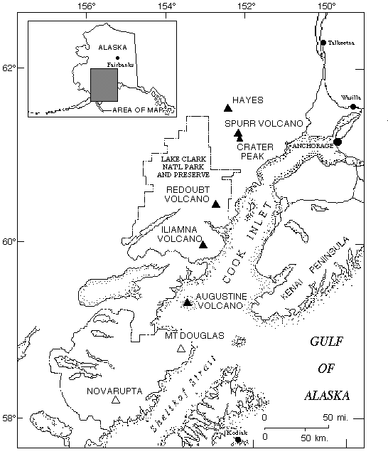
Browse_Graphic_File_Description:
Map of the Cook Inlet area, Alaska showing the location of
the Cook inlet volcanoes included in this report. Filled
triangles = volcanoes of this report; open triangles = location
of other nearby volcanoes.
Browse_Graphic_File_Type: GIF
Browse_Graphic:
Browse_Graphic_File_Name:
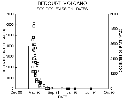
Browse_Graphic_File_Description:
Graph of average SO2 and CO2 emission rates (metric tonnes per day) from
Redoubt Volcano, March 1990 to April 1993. Open boxes = average sulfur
dioxide emission rate for a single flight; closed triangles = carbon
dioxide emission rate; vertical solid line = onset of 1989 - 1990
eruptions of Redoubt Volcano.
Browse_Graphic_File_Type: GIF
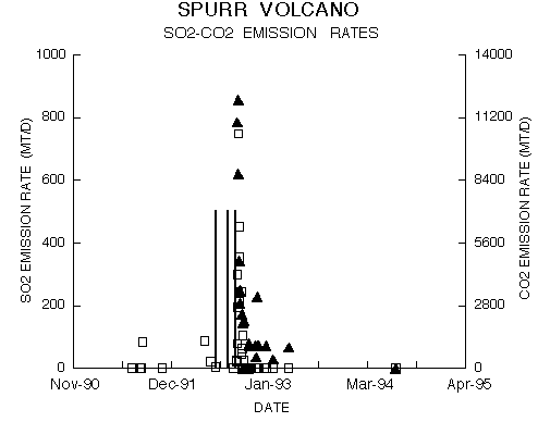
Browse_Graphic:
Browse_Graphic_File_Name: http://pubs.usgs.gov/of/1995/of95-055/core/meta/gifs/spurr.gif
Browse_Graphic_File_Description:
Graph of average SO2 and CO2 emission rates (metric tonnes per day) from
Spurr volcano, July 1991 to July 1994. Open boxes = average sulfur
dioxide emission rate; closed triangles = carbon dioxide emission rate;
vertical solid lines = 1992 eruptions of Spurr Volcano.
Browse_Graphic_File_Type: GIF
Browse_Graphic:
Browse_Graphic_File_Name: http://pubs.usgs.gov/of/1995/of95-055/core/meta/gifs/ilithm.gif
Browse_Graphic_File_Description:
Graph of average SO2 and CO2 emission rates (metric tonnes per day MT/D)
from Iliamna volcano, from Ilianma Volcano, March 1990 to April 1993.
Open boxes = average sulfur dioxide emission rate; closed triangle =
CO2 emission rate.
Browse_Graphic_File_Type: GIF
Browse_Graphic:
Browse_Graphic_File_Name: http://pubs.usgs.gov/of/1995/of95-055/core/meta/gifs/augthm.gif
Browse_Graphic_File_Description:
Graph of average SO2 and CO2 emission rates (metric tonnes per day) from
Augustine volcano, March 1990 to July 1994. Open boxes = average
sulfur dioxide emission rate; closed triangle = CO2 emission rate.
Browse_Graphic_File_Type: GIF