Citation:
Citation_Information:
Originator: Edwin L. Harp
Originator: Randall W. Jibson
Publication_Date: 1995
Title:
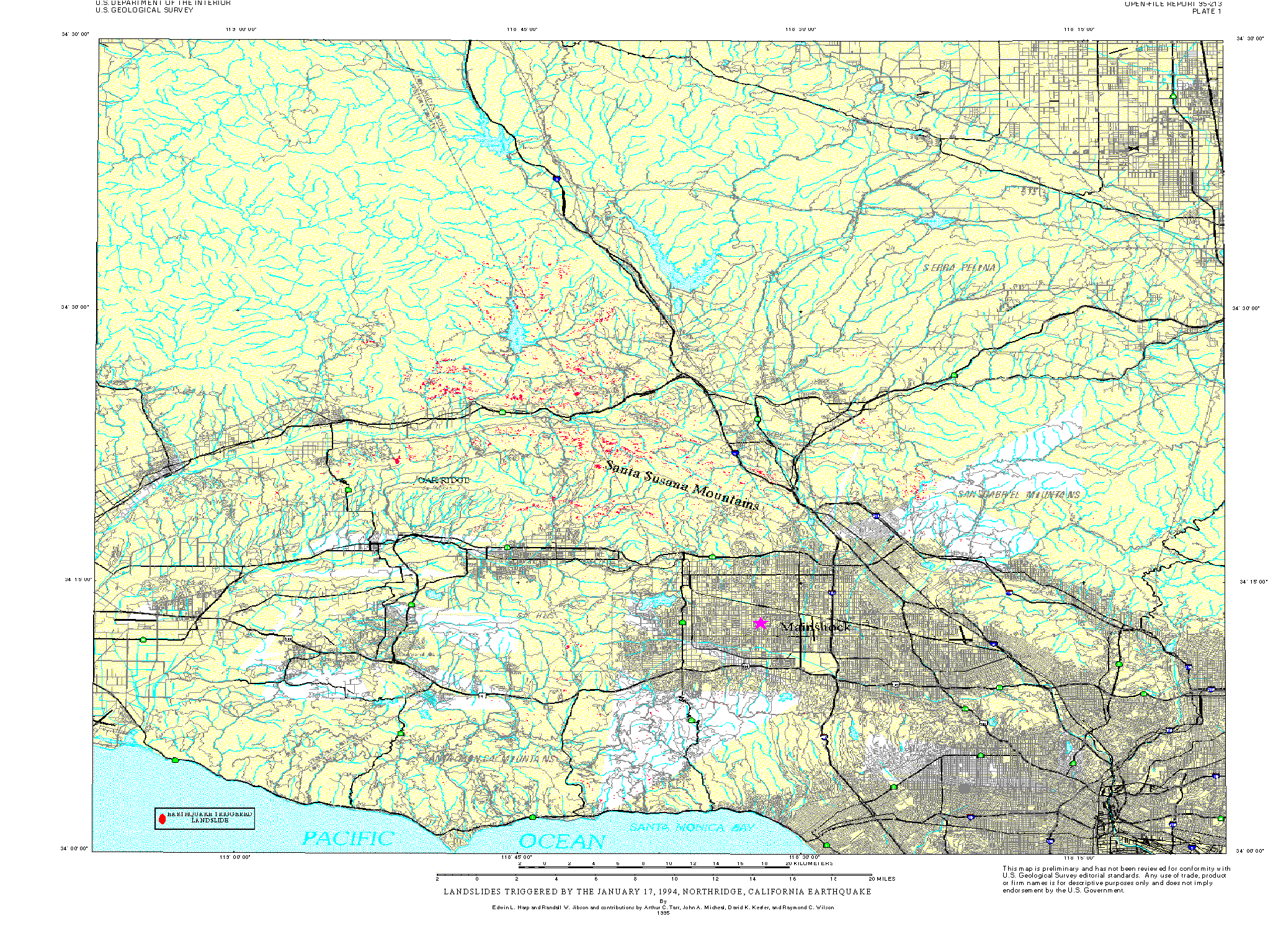
Inventory of landslides triggered by the 1994 Northridge, California earthquake
Geospatial_Data_Presentation_Form: map
Series_Information:
Series_Name: U.S. Geological Survey Open-File Report
Issue_Identification: 95-213
Other_Citation_Details:
Digital files of landslide map can be accessed off of the greenwood server both as HPGL2 graphics files and ARC/INFO GIS files.
Online_Linkage: http://pubs.usgs.gov/of/1995/ofr-95-0213/
Description:
Abstract:
The 17 January 1994 Northridge, California, earthquake (M=6.7)
triggered more than 11,000 landslides over an area of about 10,000
km². Most of the landslides were concentrated in a 1,000-km² area
that includes the Santa Susana Mountains and the mountains north of
the Santa Clara River valley. We mapped landslides triggered by the
earthquake in the field and from 1:60,000-scale aerial photography
provided by the U.S. Air Force and taken the morning of the
earthquake; these were subsequently digitized and plotted in a
GIS-based format, as shown on the accompanying maps (which also are
accessible via Internet). Most of the triggered landslides were
shallow (1-5 m), highly disrupted falls and slides in weakly
cemented Tertiary to Pleistocene clastic sediment. Average volumes
of these types of landslides were less than 1,000 m³, but many had
volumes exceeding 100,000 m³. Many of the larger disrupted slides
traveled more than 50 m, and a few moved as far as 200 m from the
bases of steep parent slopes. Deeper ( >5 m) rotational slumps and
block slides numbered in the hundreds, a few of which exceeded
100,000 m³ in volume. The largest triggered landslide was a block
slide having a volume of 8X10E06 m³. Triggered landslides damaged or
destroyed dozens of homes, blocked roads, and damaged oil-field
infrastructure. Analysis of landslide distribution with respect to
variations in (1) landslide susceptibility and (2) strong shaking
recorded by hundreds of instruments will form the basis of a seismic
landslide hazard analysis of the Los Angeles area.
Purpose:
This extensive database will allow quantitative modeling of the
relation between strong ground shaking, landslide susceptibility,
and landslide distribution. The area of the greatest landslide
concentration currently is undeveloped, but many parts of this area
in the Santa Susana Mountains are slated for future dense
residential development. We anticipate using the data and modeling
results from the Northridge earthquake to produce regional maps of
earthquake-induced landslide hazards that can be used to make
informed decisions regarding development in the areas most
susceptible to seismically triggered landsliding.
Time_Period_of_Content:
Time_Period_Information:
Single_Date/Time:
Calendar_Date: 1995
Currentness_Reference: publication date
Status:
Progress: Complete
Maintenance_and_Update_Frequency: None planned
Spatial_Domain:
Bounding_Coordinates:
West_Bounding_Coordinate: -119.17
East_Bounding_Coordinate: -118.13
North_Bounding_Coordinate: 34.75
South_Bounding_Coordinate: 34.0
Access_Constraints: none
Use_Constraints: none
Point_of_Contact:
Contact_Information:
Contact_Person_Primary:
Contact_Person: Harp, Edwin L
Contact_Organization: USGS-GEO-CRG-GHZ
Contact_Address:
Address_Type: mailing and physical address
Address:
Mail Stop 966, USGS
P.O. Box 25046
City: Lakewood
State_or_Province: CO
Postal_Code: 80225
Country: US
Contact_Voice_Telephone: 303-273-8557
Contact_Electronic_Mail_Address: [email protected]
Keywords:
Theme:
Theme_Keyword_Thesaurus: USGS Thesaurus
Theme_Keyword: geology
Theme_Keyword: landslides
Theme_Keyword: maps and atlases
Theme_Keyword: landslide susceptibility assessment
Theme_Keyword: geospatial datasets
Theme:
Theme_Keyword_Thesaurus: National Geologic Map Database Catalog themes, augmented
Theme_Keyword: 3400 - Graphical
Theme_Keyword: 3100 - Vector
Theme_Keyword: 3110 - ESRI
Theme_Keyword: 3112 - export
Theme_Keyword: 3430 - HPGL
Theme_Keyword: 1500 - Hazards
Theme_Keyword: 1501 - Earthquakes
Theme_Keyword: 1503 - Landslides
Theme:
Theme_Keyword_Thesaurus: ISO 19115 Topic Categories
Theme_Keyword: geoscientificInformation
Place:
Place_Keyword_Thesaurus: Augmented FIPS 10-4 and FIPS 6-4
Place_Keyword: f06037 = Los Angeles
Browse_Graphic:
Data_Set_Credit:
David Keefer and Ray Wilson of the U.S. Geological Survey assisted in
the post-earthquake reconnaissance efforts and in defining the
landslide limits. John Michael and Art Tarr of the U.S. Geological
Survey helped construct the digital landslide map. Al Barrows and Pam
Irvine of the California Division of Mines and Geology, and Robert
Larson of Los Angeles County provided useful information on the
location and nature of many landslides triggered by the earthquake.