Citation:
Citation_Information:
Originator: Jonathan Godt
Originator: Jeffrey Coe
Publication_Date: 2003
Title:
Map showing alpine debris flows triggered by a July 28, 1999 thunderstorm in the central Front Range of Colorado: Debris-flow initiation points
Edition: 1.0
Geospatial_Data_Presentation_Form: vector digital data
Series_Information:
Series_Name: U.S. Geological Survey Open-File Report
Issue_Identification: 03-50
Publication_Information:
Publication_Place: Denver, Colorado
Publisher: U.S. Geological Survey
Online_Linkage: http://pubs.usgs.gov/of/2003/ofr-03-050/
Larger_Work_Citation:
Citation_Information:
Originator: Jonathan W. Godt
Originator: Jeffrey A. Coe
Publication_Date: 2003
Title:
Map showing alpine debris flows triggered by a July 28, 1999 thunderstorm in the central Front Range of Colorado
Edition: 1.0
Geospatial_Data_Presentation_Form: map
Series_Information:
Series_Name: U.S. Geological Survey Open-File Report
Issue_Identification: 03-50
Online_Linkage: http://pubs.usgs.gov/of/2003/ofr-03-050/
Description:
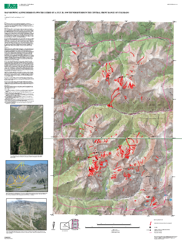
Abstract:
On July 28, 1999, about 480 debris flows were triggered by an
afternoon thunderstorm along the Continental Divide in Clear
Creek and Summit counties in the central Front Range of
Colorado. This cover shows the initiation locations of the
debris flows. Jonathan Godt and Jeffrey Coe mapped the debris
flows from 1:12,000 scale color aerial photography using a Kern
PG-2 photogrammetric plotter. The photographs were scaled and
oriented to the topographic base map using prominent
topographic landmarks and plotted on a transparent polyester
overlay registered to the topographic base maps at 1:12,000
scale. The mapped landslides were digitized manually in
ArcInfo. The final scale of the data are 1:24,000. For soil
slips, the initiation point was easily identified as the center
of the headscarp of the landslide failure. However, for the
non-soil slip category, the initiation locations in the
database may represent multiple small rills. The initiation
locations of the fire-hose flows are the highest point in the
bedrock channel that appeared freshly scoured in the aerial
photographs.
Purpose:
The purpose of these data is provide an inventory the debris
flows that were triggered over a 2-square kilometer area in
the central Front Range of Colorado by a July 28, 1999
thunderstorm. These data do not consitute a debris-flow hazard
map of the area.
Time_Period_of_Content:
Time_Period_Information:
Single_Date/Time:
Calendar_Date: 20000911
Currentness_Reference: ground condition
Status:
Progress: Complete
Maintenance_and_Update_Frequency: None planned
Spatial_Domain:
Bounding_Coordinates:
West_Bounding_Coordinate: -105.890558
East_Bounding_Coordinate: -105.761486
North_Bounding_Coordinate: 39.765877
South_Bounding_Coordinate: 39.591239
Keywords:
Theme:
Theme_Keyword_Thesaurus: USGS Thesaurus
Theme_Keyword: landslides
Theme_Keyword: geospatial datasets
Theme:
Theme_Keyword_Thesaurus: ISO 19115 Topic Categories
Theme_Keyword: geoscientificInformation
Place:
Place_Keyword_Thesaurus: Augmented FIPS 10-4 and FIPS 6-4
Place_Keyword: f08117 = Summit
Place_Keyword: f08019 = Clear Creek
Place_Keyword: f08049 = Grand
Access_Constraints: none
Use_Constraints:
This map is an inventory map, not hazard map, and should not be enlarged to a scale larger than 1:24,000.
Point_of_Contact:
Contact_Information:
Contact_Person_Primary:
Contact_Person: Jonathan Godt
Contact_Organization: U.S. Geological Survey
Contact_Position: Physical Scientist
Contact_Address:
Address_Type: mailing address
Address: Box 25046, MS 966
City: Denver
State_or_Province: CO
Postal_Code: 80225
Country: USA
Contact_Voice_Telephone: 303-273-8626
Contact_Facsimile_Telephone: 303-273-8600
Contact_Electronic_Mail_Address: [email protected]
Hours_of_Service: 8am - 4pm MST
Contact_Instructions: e-mail preferred contact
Browse_Graphic:
Native_Data_Set_Environment:
Microsoft Windows 2000 Version 5.0 (Build 2195) Service Pack 2; ESRI ArcCatalog 8.2.0.700