Citation:
Citation_Information:
Originator: Charles L. Pillmore
Publication_Date: 2003
Title:
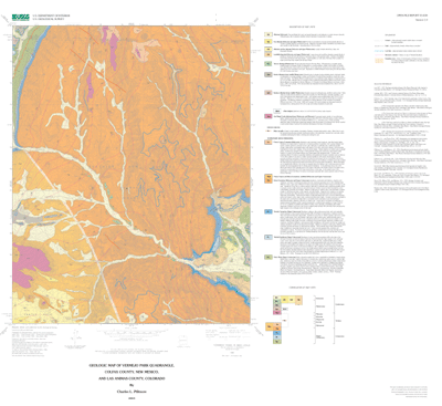
Geologic map of the Vermejo Park quadrangle, Colfax County, New Mexico, and Las Animas County, Colorado
Edition: Version 1.0
Geospatial_Data_Presentation_Form: map
Series_Information:
Series_Name: U.S. Geological Survey Open-File Report
Issue_Identification: 03-438
Publication_Information:
Publication_Place: Denver, Colorado
Publisher: U.S. Geological Survey
Online_Linkage: http://pubs.usgs.gov/of/2003/ofr-03-438/
Description:
Abstract:
The Raton basin is a large asymmetric syncline (2500 mi2 area) that extends from Huerfano Park, Colorado to Cimarron, New Mexico. As used here, the basin is defined by the limits of the outcrop of the Trinidad Sandstone. The Cretaceous and Tertiary rocks are sharply flexed to form hogbacks along the western margin of the basin on the east flank of the Sangre de Cristo Mountains. These rocks assume more gentle dips along the other margins of the Raton basin and are highly dissected. The Late Cretaceous in the Raton basin was a period of emergence of land and retreat of the Cretaceous epeiric sea. The coastline advanced eastward across New Mexico, as broad prograding deltaic and barrier coastal plains were formed seaward of aggrading fluvial systems. This map depicts the stratigraphic context and areal extent of uppermost Cretaceous and Paleocene rocks in the Raton basin including the marine Pierre Shale, marginal-marine Trinidad Sandstone, non-marine coal-bearing Vermejo Formation, non-marine coal-bearing Raton Formation and non-marine, non-coal-bearing Poison Canyon Formation.
Purpose:
This is a general-purpose geologic map of bedrock and surficial deposits in the Raton basin of northern New Mexico. It was compiled to provide a geologic context for regional interpretation of stratigraphic relations and coal resources of the Raton basin. This map was published following the untimely death of the author on August 22, 2003.
Supplemental_Information:
Geospatial datafiles included in this data set:
verm_geol(.shp)  geologic units
verm_coal(.shp)  coal bed line features
verm_cont(.shp)  structure contours
vermejo_base.tif(.tfw)  1:24,000 scale topographic base
Any use of trade, product, or firm names is for descriptive purposes
only and does not imply endorsement by the
U.S. Government.
Although this Federal Geographic Data Committee-compliant metadata
file is intended to document the data set in nonproprietary form,
as well as in ARC/INFO format, this metadata file may include some
ARC/INFO-specific terminology.
Time_Period_of_Content:
Time_Period_Information:
Single_Date/Time:
Calendar_Date: 2003
Currentness_Reference: publication date
Status:
Progress: Complete
Maintenance_and_Update_Frequency: none planned
Spatial_Domain:
Bounding_Coordinates:
West_Bounding_Coordinate: -105.125
East_Bounding_Coordinate: -105.0
North_Bounding_Coordinate: 37.0
South_Bounding_Coordinate: 36.875
Keywords:
Theme:
Theme_Keyword_Thesaurus: USGS Thesaurus
Theme_Keyword: coal resources
Theme_Keyword: Cretaceous
Theme_Keyword: stratigraphy
Theme_Keyword: geology
Theme_Keyword: geologic maps
Theme_Keyword: bedrock geologic units
Theme_Keyword: structure contours
Theme_Keyword: geospatial datasets
Theme:
Theme_Keyword_Thesaurus: American Geological Institute (AGI) Glossary of Geology
Theme_Keyword: coal resources
Theme_Keyword: Cretaceous stratigraphy
Theme:
Theme_Keyword_Thesaurus: ISO 19115 Topic Categories
Theme_Keyword: geoscientificInformation
Place:
Place_Keyword_Thesaurus: U.S. Board on Geographic Names
Place_Keyword: Vermejo Park
Place_Keyword: Raton
Place_Keyword: Raton basin
Place_Keyword: Rio Grande Rift
Place_Keyword: New Mexico
Place:
Place_Keyword_Thesaurus: Augmented FIPS 10-4 and FIPS 6-4
Place_Keyword: f35007 = Colfax
Place_Keyword: f08071 = Las Animas
Access_Constraints: none
Use_Constraints:
none. However, acknowledgment of the U.S. Geological survey would be appreciated in products derived from these data.
Point_of_Contact:
Contact_Information:
Contact_Person_Primary:
Contact_Person: Ren Thompson
Contact_Organization: U.S. Geological Survey
Contact_Address:
Address_Type: mailing and physical address
Address: USGS, MS 980, Box 25046, Denver Federal Center
City: Denver
State_or_Province: CO
Postal_Code: 80225-0046
Country: USA
Contact_Voice_Telephone: (303) 236-0929
Contact_Electronic_Mail_Address: [email protected]
Browse_Graphic:
Browse_Graphic:
Data_Set_Credit:
Digital GIS assistance by Sharon Smith and Paco VanSistine, Earth Surface Processes, USGS
Native_Data_Set_Environment:
SunOS, 5.8, sun4u UNIX
ARC/INFO version 8.1