Citation:
Citation_Information:
Originator: Douglas M. Morton
Originator: F. Harold Weber, Jr.
Publication_Date: 2003
Title:
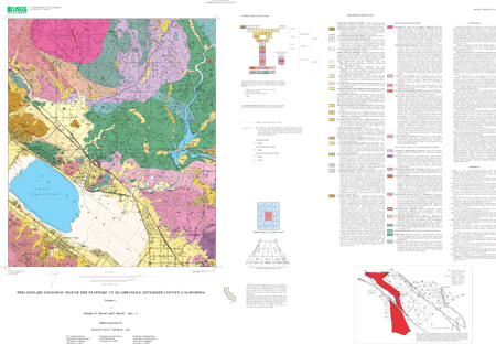
Preliminary geologic map of the Elsinore 7.5' quadrangle, Riverside County, California
Edition: Version 1.0
Geospatial_Data_Presentation_Form: vector digital data
Series_Information:
Series_Name: U.S. Geological Survey Open-File Report
Issue_Identification: 03-281
Publication_Information:
Publication_Place: Menlo Park, California
Publisher: U.S. Geological Survey
Online_Linkage: http://pubs.usgs.gov/of/2003/0281/
Description:
Abstract:
The Elsinore quadrangle is located in the northern part of the Peninsular Ranges Province and includes parts of two structural blocks, or structural subdivisions of the province. The active Elsinore Fault Zone diagonally crosses the southwest corner of the quadrangle, and is a major element of the right-lateral strike-slip San Andreas Fault system. The Elsinore Fault Zone separates the Santa Ana Mountains block west of the fault zone from the Perris block to the east. Internally both blocks are relatively stable and within the quadrangle are characterized by the presence of widespread erosional surfaces of low relief.
Within the quadrangle the Santa Ana Mountains block is underlain by undifferentiated granitic rocks of the Cretaceous Peninsular Ranges batholith, but to the west, includes widespread pre-batholithic Mesozoic rocks.
The Perris block is underlain by a combination of batholithic and prebatholithic rocks, the latter consisting of metasedimentary rocks of low metamorphic grade; sub-greenschist grade. The most abundant lithology is phyllite but includes locally thick sections of impure quartzite. Minor sills, dikes, and small elongate plutons of fine-grained hornblende gabbro intrude the phyllite. Thin layers of tremolite-bearing marble occur locally. Also local are thin layers of manganese-bearing rocks. Both rhodonite and manganese oxides occur in these layers. The phyllite has a regular northwest strike throughout the main body of metamorphic rock giving rise to a homoclinal section over 25,000 feet thick. The layering-schistocity of these rocks is transposed bedding and is not stratigraphic thickness.
In the northwest corner of the quadrangle is a series of Cretaceous volcanic and associated sedimentary rocks in the northwest corner of the quadrangle contain widespread primary sedimentary structures and appear to post date the metamorphism of the phyllite. The volcanic rocks are part of the Estelle Mountain volcanics of primarily rhyolitic composition. The sedimentary rocks are well indurated, perhaps incipiently metamorphosed, siliceous rocks containing local conglomerate beds.
Parts of three plutonic complexes are included within the quadrangle, all part of the composite Peninsular Ranges batholith. In the southeast corner is the northwest part of the Paloma Valley ring complex, which is elliptical in plan and consists of an older ring-dike and two subsidiary short-arced dikes that were emplaced into gabbro by magmatic stoping. Small to large stoped blocks of gabbro are common within the ring-dikes. A younger ring-set, made up of hundreds of thin pegmatite dikes, occur largely within the central part of the complex. Only the northern part of the older ring dike occurs within the quadrangle. Stoped gabbro masses occur near the southeast margin of the quadrangle.
In the northern part of the quadrangle is the southern part of the composite Gavilan ring complex of mostly tonalite composition. Hypersthene, although not usual in tonalite in the batholith, is a characteristic mineral of most of the rock of this complex. The Gavilan ring complex is a shallow intrusive that appears to be tilted up to the northeast. Fabric of the rocks changes in texture from hypauthomorphic-granular in the east to semiporphyritic in the west. The main part of the complex appears to have been emplaced by magmatic stoping. Several inactive gold mines, Goodhope, Gavilan, and Santa Rosa, are located within the complex.
Within the Gavilan ring complex is the south-half of the Arroyo del Toro pluton. This near circular-in-plan pluton consists of massive-textured granodiorite that is essentially devoid of inclusions, and at one time was quarried for building stone.
The Elsinore Fault Zone forms a complex series of pull-apart basins. The largest and most pronounced of these pull-apart basins forms a flat-floored closed depression, La Laguna, which is partly filled by Lake Elsinore. This basin forms the terminus for the San Jacinto River. During excessively wet periods the La Laguna fills and the overflow passes through Warm Springs Valley into Temescal Wash which joins the Santa Ana River at Corona. La Laguna, bounded by active faults, is flanked by both Pleistocene and Holocene alluvial fans emanating from both the Perris block and the Santa Ana Mountains. North of La Laguna are exposures of the Paleocene Silverado Formation. Clay beds of the Silverado Formation have been an important source of clay. Overlying the Silverado Formation are discontinuous exposures of conglomeratic younger Tertiary sedimentary rocks that are tentatively correlated with the Pauba Formation.
Purpose:
The data set for the Elsinore 7.5' quadrangle was prepared under the U.S. Geological Survey Southern California Areal Mapping Project (SCAMP) as part of an ongoing effort to develop a regional geologic framework of southern California and to utilize a Geographic Information System (GIS) format to create regional digital geologic databases. These regional databases are being developed as contributions to the National Geologic Map Database of the National Cooperative Geologic Mapping Program of the USGS.
Supplemental_Information: None
Time_Period_of_Content:
Time_Period_Information:
Single_Date/Time:
Calendar_Date: 2003
Currentness_Reference: New data
Status:
Progress: Complete
Maintenance_and_Update_Frequency: None planned
Spatial_Domain:
Bounding_Coordinates:
West_Bounding_Coordinate: -117.37509053
East_Bounding_Coordinate: -117.24990947
North_Bounding_Coordinate: 33.74999995
South_Bounding_Coordinate: 33.62498421
Keywords:
Theme:
Theme_Keyword_Thesaurus: USGS Thesaurus
Theme_Keyword: geology
Theme_Keyword: geologic maps
Theme_Keyword: bedrock geologic units
Theme_Keyword: faulting (geologic)
Theme_Keyword: geospatial datasets
Theme:
Theme_Keyword_Thesaurus: ISO 19115 Topic Categories
Theme_Keyword: geoscientificInformation
Place:
Place_Keyword_Thesaurus: none
Place_Keyword: California
Place_Keyword: Riverside County
Place_Keyword: Elsinore 7.5' quadrangle
Place:
Place_Keyword_Thesaurus: Augmented FIPS 10-4 and FIPS 6-4
Place_Keyword: f06065 = Riverside
Stratum:
Stratum_Keyword_Thesaurus: None
Stratum_Keyword: Cretaceous tonalite
Stratum_Keyword: Cretaceous granodiorite
Stratum_Keyword: Mesozoic metamorphics
Stratum_Keyword: Elsinore Fault
Temporal:
Temporal_Keyword_Thesaurus: None
Temporal_Keyword: Mesozoic
Temporal_Keyword: Cretaceous
Temporal_Keyword: Elsinore Fault
Access_Constraints: None
Use_Constraints:
The Elsinore 7.5' geologic-map database should be used to evaluate and understand the geologic character of the Elsinore 7.5' quadrangle as a whole. The data should not be used for purposes of site-specific land-use planning or site-specific geologic evaluations. The database is sufficiently detailed to identify and characterize many actual and potential geologic hazards represented by faults and landslides and posed by ground subsidence and earthquake-generated ground shaking. However, it is not sufficiently detailed for site-specific determinations or evaluations of these features. Faults shown do not take the place of fault-rupture hazard zones designated by the California State Geologist (see Hart, 1988).
Use of this digital geologic-map database should not violate the spatial resolution of the data. Although the digital form of the data removes the constraint imposed by the scale of a paper map, the detail and accuracy inherent in map scale are also present in the digital data. The fact that this database was compiled and edited at a scale of 1:24,000 means that higher resolution information may not have been uniformly retained in the dataset. Plotting at scales larger than 1:24,000 will not yield greater real detail, although it may reveal fine-scale irregularities below the intended resolution of the database. Similarly, although higher resolution data is incorporated in most of the map, the resolution of the combined output will be limited by the lower resolution data.
Point_of_Contact:
Contact_Information:
Contact_Person_Primary:
Contact_Person: Douglas M. Morton
Contact_Organization:
U.S. Geological Survey, Western Region, Earth Surface Processes Team
Contact_Position: Project Geologist
Contact_Address:
Address_Type: mailing address
Address: U.S. Geological Survey
Address: Department of Earth Sciences
Address: University of California, Riverside
City: Riverside
State_or_Province: California
Postal_Code: 92521
Country: USA
Contact_Voice_Telephone: (909)276-6397
Contact_Facsimile_Telephone: (909)276-6295
Contact_Electronic_Mail_Address: [email protected]
Browse_Graphic:
Browse_Graphic:
Data_Set_Credit:
Geologic mapping and digital preparation of this report were sponsored jointly by (1) the National Cooperative Geologic Mapping Program of the U.S. Geological Survey, (2) the California Geological Survey, and (3) the Southern California Areal Mapping Project (SCAMP).
Native_Data_Set_Environment:
SunOS, 5.7, sun4u UNIX
ARC/INFO version 7.2.1
Cross_Reference:
Citation_Information:
Originator: Morton, D.M.
Publication_Date: 1999
Title:
Preliminary digital geologic map of the Santa Ana 30'x60' quadrangle, southern California
Edition: 1.0
Geospatial_Data_Presentation_Form: vector digital data
Series_Information:
Series_Name: U.S. Geological Survey Open-File Report
Issue_Identification: 99-172
Publication_Information:
Publication_Place: Menlo Park, California
Publisher: U.S. Geological Survey
Online_Linkage: http://pubs.usgs.gov/of/1999/of99-172/