Citation:
Citation_Information:
Originator: Douglas M. Morton
Publication_Date: 2003
Title:
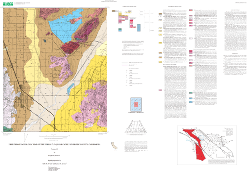
Preliminary geologic Map of the Perris 7.5' Quadrangle, Riverside County, California
Edition: Version 1.0
Geospatial_Data_Presentation_Form: vector digital data
Series_Information:
Series_Name: U.S. Geological Survey Open-File Report
Issue_Identification: 03-270
Publication_Information:
Publication_Place: Menlo Park, California
Publisher: U.S. Geological Survey
Online_Linkage: http://pubs.usgs.gov/of/2003/0270/
Description:
Abstract:
This data set maps and describes the geology of the Perris 7.5' quadrangle, Riverside County, California. Created using Environmental Systems Research Institute's ARC/INFO software, the data base consists of the following items: (1) a map coverage containing geologic contacts and units, (2) a coverage containing structural data, (3) a coverage containing geologic unit annotation and leaders, and (4) attribute tables for geologic units (polygons), contacts (arcs), and site-specific data (points). In addition, the data set includes the following graphic and text products: (1) a postscript graphic plot-file containing the geologic map, topography, cultural data, a Correlation of Map Units (CMU) diagram, a Description of Map Units (DMU), and a key for point and line symbols, and (2) PDF files of the Readme (including the metadata file as an appendix), and the graphic produced by the Postscript plot file.
The Perris quadrangle is located in the northern part of the Peninsular Ranges Province within the central part of the Perris block, a relatively stable, rectangular in plan area located between the Elsinore and San Jacinto fault zones.
The quadrangle is underlain by Cretaceous age and older basement rocks. The Cretaceous plutonic rocks are part of the composite Peninsular Ranges batholith. A wide variety of intermediate composition granitic rocks are located in the quadrangle. These rocks are mainly of tonalitic composition but range from monzogranite to diorite. Most rock is faintly to intensely foliated. Many are heterogenous and contain varying amounts of meso-and melanocratic discoidal-shaped inclusions. Some rocks are composed essentially of inclusion material and some are migmatitic. Included within these granitic rocks are a few septa of Paleozoic(?) schist of upper amphibolite metamorphic grade.
Metamorphic rocks of probable Mesozoic age occur in the southwest corner of the quadrangle. Most of these rocks are well-foliated phyllite of Mesozoic age. The metamorphic grade of these rocks is greenschist or sub-greenschist. Rocks of probable Paleozoic age occur as scattered masses within plutonic rocks in the northern part of the quadrangle. These rocks are of amphibolite grade and include cordierite and sillimanite biotite schist.
In the center and southeast quarter of the quadrangle, biotite-hornblende tonalite of the Lakeview Mountains pluton is characterized by ubiquitous schlieren and by a lack of potassium feldspar. Masses of leucocratic and melanocratic rock occur scattered throughout the pluton. Mesocratic-to melanocratic discoidal-shaped inclusions are oriented parallel to the schlieren. A small body of comb-layered gabbro is located with the tonalite near the southern margin of the pluton. The tonalite contains rare-earth bearing, zoned pegmatite dikes.
Biotite-hornblende tonalite located in the southwest part of the quadrangle is part of the Val Verde pluton. This tonalite is similar to that of the Lakeview Mountains pluton but lacks the ubiquitous schlieren and contains potassium feldspar.
Diagonally crossing the quadrangle is the channel and flood plain of the ephemeral San Jacinto River. Most of the alluviated area west of the San Jacinto River consists of Pleistocene age fluvial deposits, which have a degraded upper surface that is preserved in some places near the contact with granitic rocks. The upper part of these deposits form the Paloma surface of Woodford and others (1971). A modern-to Holocene-age drainage channel is within these older Pleistocene deposits. Younger Pleistocene alluvial fans emanate from the Lakeview Mountains east of the San Jacinto River.
Purpose:
The data set for the Perris 7.5' quadrangle was prepared under the U.S. Geological Survey Southern California Areal Mapping Project (SCAMP) as part of an ongoing effort to develop a regional geologic framework of southern California, and to utilize a Geographic Information System (GIS) format to create regional digital geologic databases. These regional databases are being developed as contributions to the National Geologic Map Database of the National Cooperative Geologic Mapping Program of the USGS.
Supplemental_Information: none
Time_Period_of_Content:
Time_Period_Information:
Single_Date/Time:
Calendar_Date: 2003
Currentness_Reference: New data
Status:
Progress: Complete
Maintenance_and_Update_Frequency: As Needed
Spatial_Domain:
Bounding_Coordinates:
West_Bounding_Coordinate: -117.25009084
East_Bounding_Coordinate: -117.12490892
North_Bounding_Coordinate: 33.87500054
South_Bounding_Coordinate: 33.7499832
Keywords:
Theme:
Theme_Keyword_Thesaurus: USGS Thesaurus
Theme_Keyword: geology
Theme_Keyword: geologic maps
Theme_Keyword: bedrock geologic units
Theme_Keyword: surficial geologic units
Theme_Keyword: geospatial datasets
Theme:
Theme_Keyword_Thesaurus: ISO 19115 Topic Categories
Theme_Keyword: geoscientificInformation
Place:
Place_Keyword_Thesaurus: none
Place_Keyword: California
Place_Keyword: Riverside County
Place_Keyword: Perris 7.5' quadrangle
Place:
Place_Keyword_Thesaurus: Augmented FIPS 10-4 and FIPS 6-4
Place_Keyword: f06065 = Riverside
Stratum:
Stratum_Keyword_Thesaurus: none
Stratum_Keyword: Cretaceous tonalite and granodiorite
Stratum_Keyword: Mesozoic metamorphics
Stratum_Keyword: Quaternary alluvium
Temporal:
Temporal_Keyword_Thesaurus: none
Temporal_Keyword: Cretaceous
Temporal_Keyword: Mesozoic
Temporal_Keyword: Quarternary
Access_Constraints: none
Use_Constraints:
The Perris 7.5' geologic-map database should be used to evaluate and understand the geologic character of the Perris 7.5' quadrangle as a whole. The data should not be used for purposes of site-specific land-use planning or site-specific geologic evaluations. The database is sufficiently detailed to identify and characterize many actual and potential geologic hazards represented by faults and landslides and posed by ground subsidence and earthquake-generated ground shaking. However, it is not sufficiently detailed for site-specific determinations or evaluations of these features. Faults shown do not take the place of fault-rupture hazard zones designated by the California State Geologist (see Hart, 1988).
Use of this digital geologic-map database should not violate the spatial resolution of the data. Although the digital form of the data removes the constraint imposed by the scale of a paper map, the detail and accuracy inherent in map scale are also present in the digital data. The fact that this database was compiled and edited at a scale of 1:24,000 means that higher resolution information may not have been uniformly retained in the dataset. Plotting at scales larger than 1:24,000 will not yield greater real detail, although it may reveal fine-scale irregularities below the intended resolution of the database. Similarly, although higher resolution data is incorporated in most of the map, the resolution of the combined output will be limited by the lower resolution data.
Point_of_Contact:
Contact_Information:
Contact_Person_Primary:
Contact_Person: Douglas M. Morton
Contact_Organization:
U.S. Geological Survey, Western Region, Earth Surface Processes Team
Contact_Position: Project Geologist
Contact_Address:
Address_Type: mailing address
Address: U.S. Geological Survey
Address: Department of Earth Sciences
Address: University of California, Riverside
City: Riverside
State_or_Province: California
Postal_Code: 92521
Country: United States of America
Contact_Voice_Telephone: (909) 276-6397
Contact_Facsimile_Telephone: (909) 276-6295
Contact_Electronic_Mail_Address: [email protected]
Browse_Graphic:
Browse_Graphic:
Data_Set_Credit:
Geologic mapping and digital preparation of this report were sponsored jointly by (1) the National Cooperative Geologic Mapping Program of the U.S. Geological Survey, (2) U.S. Air Force, (3) the California Geological Survey, and (4) the Southern California Areal Mapping Project (SCAMP).
Native_Data_Set_Environment:
SunOS, 5.8, sun4m UNIX
ARC/INFO version 7.2.1
Cross_Reference:
Citation_Information:
Originator: Morton, D.M.
Publication_Date: 1999
Title:
Preliminary digital geologic map of the Santa Ana 30'x60' quadrangle, southern California, version 1.0.
Geospatial_Data_Presentation_Form: vector digital data
Series_Information:
Series_Name: U.S. Geological Survey Open-File Report
Issue_Identification: 99-172
Publication_Information:
Publication_Place: California
Publisher: U.S. Geological Survey
Online_Linkage: http://pubs.usgs.gov/of/1999/of99-172/