Citation:
Citation_Information:
Originator: Douglas M. Morton
Originator: Michael P. Kennedy
Publication_Date: 2003
Title:
Geologic Map of the Bachelor Mountain 7.5' Quadrangle,
Riverside County, California
Edition: Version 1.0
Geospatial_Data_Presentation_Form: vector digital data
Series_Information:
Series_Name: U.S. Geological Survey Open-File Report
Issue_Identification: 03-103
Publication_Information:
Publication_Place: Menlo Park, California
Publisher: U.S. Geological Survey
Online_Linkage: http://pubs.usgs.gov/of/2003/0103/
Description:
Abstract:
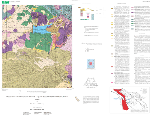
This data set maps and describes the geology of the Bachelor
Mountain 7.5' quadrangle, Riverside County, California.
Created using Environmental Systems Research Institute's
ARC/INFO software, the data base consists of the following
items: (1) a map coverage containing geologic contacts and
units, (2) a coverage containing structural data, (3) a
coverage containing geologic unit annotation and leaders, and
(4) attribute tables for geologic units (polygons), contacts
(arcs), and site-specific data (points). In addition, the data
set includes the following graphic and text products: (1) a
postscript graphic plot-file containing the geologic map,
topography, cultural data, a Correlation of Map Units (CMU)
diagram, a Description of Map Units (DMU), and a key for point
and line symbols, and (2) PDF files of the Readme (including
the metadata file as an appendix), and the graphic produced by
the Postscript plot file.
The Bachelor Mountain quadrangle is located in the southern
Perris block area of the Peninsular Ranges Province.
Internally, the Perris block is a relatively stable area
located between the Elsinore and San Jacinto Fault zones.
In contrast to the rest of the quadrangle, the southern half is
underlain almost entirely by young sedimentary units, chiefly
the Pauba Formation of Pleistocene age. The Pauba Formation
largely consists of well-indurated sandstone containing sparse
cobble-to boulder conglomerate beds. It is eroded into a
gentle badlands topography in most of its extent. Remnants of
scattered, discontinuous alluvial deposits suggest the Pauba
Formation was covered by relatively thin younger Pleistocene
sediments. The most extensive remnant of these younger
deposits forms a surface of low relief at Buck Mesa, just north
of Long Valley.
The northern half of the quadrangle is underlain by Mesozoic
metasedimentary rocks that are intruded by plutonic rocks of
the Cretaceous Peninsular Ranges batholith. The western part
of these metamorphic rocks are mainly phyllite, grading
eastward into quartzitic and schistose rocks. Metamorphic
grade increases eastward also, to biotite, cordierite-biotite,
and sillimanite schist.
The oldest batholithic rocks in the quadrangle are massive
hornblende gabbro including the large body underlying Bachelor
Mountain. Large masses of gabbro are included in granodiorite
and tonalite plutons east of Bachelor Mountain. In the
northwestern part of the quadrangle is the southeastern part of
the Paloma Valley Ring complex. This complex makes up much of
the northern part of the Murrieta quadrangle and the southern
part of the Romoland quadrangle. In the Bachelor Mountain
quadrangle, rocks of the complex are limited to foliated
tonalite which is the most mafic part of the complex. East of
Skinner Reservoir (Lake Skinner) underlying the Tucalota Hills,
is a series of north-trending massive-textured granodiorite
plutons informally termed the granodiorite of Tucalota Hills
(Morton, 1999).
The geologic map data base contains original U.S. Geological
Survey data generated by detailed field observation recorded on
1:24,000 scale aerial photographs. The map was created by
transferring lines from the aerial photographs to a 1:24,000
scale topographic base. The map was digitized and lines,
points, and polygons were subsequently edited using standard
ARC/INFO commands. Digitizing and editing artifacts
significant enough to display at a scale of 1:24,000 were
corrected. Within the database, geologic contacts are
represented as lines (arcs), geologic units are polygons, and
site-specific data as points. Polygon, arc, and point
attribute tables (.pat, .aat, and .pat, respectively) uniquely
identify each geologic datum.
Purpose:
The data set for the Bachelor Mountain 7.5' quadrangle was
prepared under the U.S. Geological Survey Southern California
Areal Mapping Project (SCAMP) as part of an ongoing effort to
develop a regional geologic framework of southern California,
and to utilize a Geographic Information System (GIS) format to
create regional digital geologic databases. These regional
databases are being developed as contributions to the National
Geologic Map Database of the National Cooperative Geologic
Mapping Program of the USGS.
Time_Period_of_Content:
Time_Period_Information:
Single_Date/Time:
Calendar_Date: 2003
Currentness_Reference: New data
Status:
Progress: Complete
Maintenance_and_Update_Frequency: As Needed
Spatial_Domain:
Bounding_Coordinates:
West_Bounding_Coordinate: -117.1250901
East_Bounding_Coordinate: -116.99990956
North_Bounding_Coordinate: 33.62499995
South_Bounding_Coordinate: 33.49998424
Keywords:
Theme:
Theme_Keyword_Thesaurus: USGS Thesaurus
Theme_Keyword: geology
Theme_Keyword: geologic maps
Theme_Keyword: bedrock geologic units
Theme_Keyword: geologic structure
Theme_Keyword: geospatial datasets
Theme:
Theme_Keyword_Thesaurus: ISO 19115 Topic Categories
Theme_Keyword: geoscientificInformation
Place:
Place_Keyword_Thesaurus: none
Place_Keyword: California
Place_Keyword: Riverside County
Place_Keyword: Bachelor Mountain 7.5' quadrangle
Stratum:
Stratum_Keyword_Thesaurus: None
Stratum_Keyword: Cretaceous gabbro
Stratum_Keyword: Cretaceous tonalite
Stratum_Keyword: Cretaceous granodiorite
Stratum_Keyword: Mesozoic and Paleozoic(?) metamorphics
Temporal:
Temporal_Keyword_Thesaurus: None
Temporal_Keyword: Mesozoic
Temporal_Keyword: Cretaceous
Access_Constraints: None
Use_Constraints:
The Bachelor Mountain 7.5' geologic-map database should be used
to evaluate and understand the geologic character of the Bachelor
Mountain 7.5' quadrangle as a whole. The data should not be used
for purposes of site-specific land-use planning or site-specific
geologic evaluations. The database is sufficiently detailed to
identify and characterize many actual and potential geologic
hazards represented by faults and landslides and posed by ground
subsidence and earthquake-generated ground shaking. However, it
is not sufficiently detailed for site-specific determinations or
evaluations of these features. Faults shown do not take the
place of fault-rupture hazard zones designated by the California
State Geologist (see Hart, 1988).
Use of this digital geologic-map database should not violate the
spatial resolution of the data. Although the digital form of the
data removes the constraint imposed by the scale of a paper map,
the detail and accuracy inherent in map scale are also present in
the digital data. The fact that this database was compiled and
edited at a scale of 1:24,000 means that higher resolution
information may not have been uniformly retained in the dataset.
Plotting at scales larger than 1:24,000 will not yield greater
real detail, although it may reveal fine-scale irregularities
below the intended resolution of the database. Similarly,
although higher resolution data is incorporated in most of the
map, the resolution of the combined output will be limited by the
lower resolution data.
Point_of_Contact:
Contact_Information:
Contact_Person_Primary:
Contact_Person: Douglas M. Morton
Contact_Organization:
U.S. Geological Survey, Western Region, Earth Surface Processes Team
Contact_Position: Project Geologist
Contact_Address:
Address_Type: mailing address
Address: U.S. Geological Survey
Address: Department of Earth Sciences
Address: University of California, Riverside
City: Riverside
State_or_Province: California
Postal_Code: 92521
Country: United States of America
Contact_Voice_Telephone: (909) 276-6397
Contact_Facsimile_Telephone: (909) 276-6295
Contact_Electronic_Mail_Address: [email protected]
Browse_Graphic:
Browse_Graphic:
Data_Set_Credit:
Geologic mapping and digital preparation of this report were
sponsored jointly by (1) the National Cooperative Geologic
Mapping Program of the U.S. Geological Survey, (2) the California
Geological Survey, and (3) the Southern California Areal Mapping
Project (SCAMP).
Native_Data_Set_Environment:
SunOS, 5.8, sun4m UNIX
ARC/INFO version 7.2.1
Cross_Reference:
Citation_Information:
Originator: Morton, D.M.
Publication_Date: 1999
Title:
Preliminary digital geologic map of the Santa Ana 30'x60' quadrangle, southern California, version 1.0.
Geospatial_Data_Presentation_Form: vector digital data
Series_Information:
Series_Name: U.S. Geological Survey Open-File Report
Issue_Identification: 99-172
Publication_Information:
Publication_Place: California
Publisher: U.S. Geological Survey
Online_Linkage: http://pubs.usgs.gov/of/1999/of99-172/