Citation:
Citation_Information:
Originator: Robert E. Powell
Publication_Date: 2002
Title:
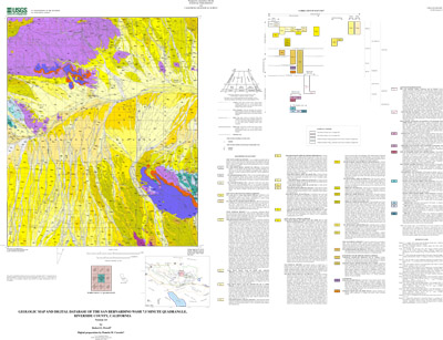
Geologic map and digital database of the San Bernardino Wash
7.5 minute quadrangle, Riverside County, California
Edition: Version 1.0
Geospatial_Data_Presentation_Form: Vector digital data
Series_Information:
Series_Name: U.S. Geological Survey Open-File Report
Issue_Identification: 02-498
Publication_Information:
Publication_Place: Menlo Park, California
Publisher: U.S. Geological Survey
Online_Linkage: http://pubs.usgs.gov/of/2002/0498/
Description:
Abstract:
This data set maps and describes the geology of the San Bernardino Wash 7.5 minute
quadrangle, Riverside County, southern California. The quadrangle, situated in
Joshua Tree National Park in the eastern Transverse Ranges physiographic and
structural province, encompasses parts of the northwestern Eagle Mountains,
east-central Pinto Basin, and eastern Pinto Mountains.
The quadrangle is underlain by a basement terrane comprising metamorphosed
Proterozoic strata, Mesozoic plutonic rocks, and Jurassic and Mesozoic and (or)
Cenozoic hypabyssal dikes. The basement terrane is capped by a widespread Tertiary
erosion surface preserved in remnants in the Pinto and Eagle Mountains and buried
beneath Cenozoic deposits in Pinto Basin. Locally, a cover of Miocene sedimentary
deposits and basalt overlie the erosion surface. A sequence of at least three
Quaternary pediments is planed into the north piedmont of the Eagle Mountains, each
in turn overlain by successively younger residual and alluvial, surficial deposits.
The Tertiary erosion surface is deformed and broken by north-northwest-trending,
high-angle, dip-slip faults in the Pinto and Eagle Mountains and an east-west
trending system of high-angle dip- and left-slip faults along the range fronts
facing Pinto Basin. In and around the San Bernardino Wash quadrangle, faults of
the north-northwest-trending set displace Miocene sedimentary rocks and basalt
deposited on the Tertiary erosion surface and some of the faults may offset
Pliocene and (or) Pleistocene deposits that accumulated on the oldest pediment.
Faults of this system appear to be overlain by Pleistocene deposits that
accumulated on younger pediments. East-west trending faults are younger than and
perhaps in part coeval with faults of the northwest-trending set.
The San Bernardino Wash database was created using ARCVIEW and ARC/INFO, which are
geographical information system (GIS) software products of Envronmental Systems
Research Institute (ESRI). The database comprises five coverages: (1) a geologic
layer showing the distribution of geologic contacts and units; (2) a structural
layer showing the distribution of faults (arcs) and fault ornamentation data
(points); (3) a layer showing the distribution of dikes (arcs); a structural point
data layer showing (4) bedding and metamorphic foliation attitudes, and (5)
cartographic map elements, including unit label leaders and geologic unit
annotation. The dataset also includes a scanned topographic base at a scale of
1:24,000. Within the database coverages, geologic contacts , faults, and dikes are
represented as lines (arcs and routes), geologic units as areas (polygons and
regions), and site-specific data as points. Polygon, region, arc, route, and point
attribute tables uniquely identify each geologic datum and link it to descriptive
tables that provide more detailed geologic information.
The digital database is accompanied by two derivative maps: (1) A portable document
file (.pdf) containing a navigable graphic of the geologic map on a 1:24,000
topographic base and (2) a PostScript graphic-file containing the geologic map on a
1:24,000 topographic base. Each of these map products is accompanied by a marginal
explanation consisting of a Description of Map Units (DMU), a Correlation of Map
Units (CMU), and a key to point and line symbols. The database is further
accompanied by three document files: (1) a readme that lists the contents of the
database and describes how to access it, (2) a pamphlet file that describes the
geology of the quadrangle and (3) this metadata file.
Purpose:
The data set for the San Bernardino Wash quadrangle has been prepared by the
Southern California Areal Mapping Project (SCAMP), a cooperative project sponsored
jointly by the U.S. Geological Survey and the California Geological Survey. The San
Bernardino Wash data set represents part of an ongoing effort to create a regional
GIS geologic database for southern California. This regional digital database, in
turn, is being developed as a contribution to the National Geologic Map Database of
the National Cooperative Geologic Mapping Program of the USGS. The San Bernardino
Wash database has been prepared in cooperation with the National Park Service as
part of an ongoing project to provide Joshua Tree National Park with a geologic map
base for use in managing Park resources and developing interpretive materials.
The digital geologic map database for the San Bernardino Wash quadrangle has been
created as a general-purpose data set that is applicable to land-related
investigations in the earth and biological sciences. Along with geologic map
databases in preparation for adjoining quadrangles, the San Bernardino Wash
database has been generated to further our understanding of bedrock and surficial
processes at work in the region and to document evidence for seismotectonic
activity in the eastern Transverse Ranges. The database is designed to serve as a
base layer suitable for ecosystem and mineral resource assessment and for building
a hydrogeologic framework for the Pinto Basin.
Supplemental_Information:
Map nomenclature and symbols
Within the geologic map database, map units are identified by standard geologic map
criteria such as formation-name, age, and lithology. The authors have attempted to
adhere to the stratigraphic nomenclature of the U.S. Geological Survey and the
North American Stratigraphic Code, but the database has not received a formal
editorial review of geologic names.
Geologic map unit labels are present in three forms in the database. First, map
unit labels are entered into the database through various items in the polygon
attribute table, dike arc attribute table, and region attribute tables. Geologic
map units are tabulated in items such as UNIT_LABEL and POLY_LABEL, where they are
identified by plain-text unit labels (e.g., Qyamg1, Prpqp). These labels do not
show subscript offsets and do not contain conventional stratigraphic age symbols,
i.e., Proterozoic appears as 'Pr'. Second, for the purpose of plotting the map,
the item PLOT_LABEL, located in the polygon attribute and map display tables,
identifies the unit label as it is plotted by Arc/Info (e.g., Qyamg1, <pqp), again
without subscripts and containing substitute characters for conventional
stratigraphic age symbols: Proterozoic appears as '<'. The substitute character in
PLOT_LABEL invokes its corresponding symbol from the GeoAge font group to generate
map plots that display conventional stratigraphic symbols. Third, annotation labels
for map units, derived from the item PLOT_LABEL but showing subscripts (e.g.,
Qyamg1), are stored in the annotation subclass anno.geo of the arc coverage
sbwash_carto/.
Time_Period_of_Content:
Time_Period_Information:
Range_of_Dates/Times:
Beginning_Date: 1964
Ending_Date: 2002
Currentness_Reference: Data collection period
Status:
Progress: Complete
Maintenance_and_Update_Frequency: As Needed
Spatial_Domain:
Bounding_Coordinates:
West_Bounding_Coordinate: -115.7500914
East_Bounding_Coordinate: -115.6249086
North_Bounding_Coordinate: 33.99999995
South_Bounding_Coordinate: 33.87498418
Keywords:
Theme:
Theme_Keyword_Thesaurus: USGS Thesaurus
Theme_Keyword: geology
Theme_Keyword: geologic maps
Theme_Keyword: surficial geologic units
Theme_Keyword: bedrock geologic units
Theme_Keyword: metamorphic rocks
Theme_Keyword: plutonic rocks
Theme_Keyword: unconsolidated deposits
Theme_Keyword: geologic structure
Theme_Keyword: geospatial datasets
Theme:
Theme_Keyword_Thesaurus: none
Theme_Keyword: fault
Theme_Keyword: erosion surface
Theme_Keyword: pediment
Theme_Keyword: soil
Theme_Keyword: alluvial deposits
Theme_Keyword: dike
Theme_Keyword: batholith
Theme_Keyword: metamorphic rocks
Theme_Keyword: plutonic rocks
Theme_Keyword: hypabyssal rocks
Theme:
Theme_Keyword_Thesaurus: ISO 19115 Topic Categories
Theme_Keyword: geoscientificInformation
Place:
Place_Keyword_Thesaurus: none
Place_Keyword: southern California
Place_Keyword: Riverside County
Place_Keyword: Joshua Tree National Park
Place_Keyword: eastern Transverse Ranges
Place_Keyword: San Bernardino Wash
Place_Keyword: Eagle Mountains
Place_Keyword: Pinto Mountains
Place_Keyword: Pinto Basin
Place_Keyword: San Bernardino Wash 7.5' quadrangle
Place_Keyword: Pinto Basin 15' quadrangle
Place_Keyword: Eagle Mountains 30' x 60' quadrangle
Place:
Place_Keyword_Thesaurus: Augmented FIPS 10-4 and FIPS 6-4
Place_Keyword: f06065 = Riverside
Stratum:
Stratum_Keyword_Thesaurus: None
Stratum_Keyword: Basalt
Stratum_Keyword:
Porphyritic quartz monzonite, monzogranite, and granodiorite of San Bernardino Wash
Stratum_Keyword: Quartzite of Pinto Mountain
Stratum_Keyword: Dolomite of Iron Chief mine
Stratum_Keyword: Alluvium
Access_Constraints: None
Use_Constraints:
Spatial Resolution. Use of this digital geologic map should not violate the
spatial resolution of the data. The San Bernardino Wash geologic map and database
was developed using digital orthophotograph quarter quadrangles (DOQQs) as a base.
DOQQs have a pixel resolution of 1 m and are accurate to a scale of 1:12,000 (1 in
= 1,000 ft). Any enlargement beyond 1:12,000 exceeds the spatial resolution of the
geologic data and should not be used in lieu of a more detailed site-specific
geologic evaluation. Similarly, the digital topographic base map is derived from
the U.S. Geological Survey, 1:24,000-scale San Bernardino Wash 7.5 minute
quadrangle (provisional edition, 1986); any enlargement beyond 1:24,000 exceeds the
spatial resolution of the topographic data. Plotting or viewing of the data at
scales larger than 1:12,000 on the DOQQ base, or larger than 1:24,000 on the
topographic base, will not yield greater real detail, although it may reveal
fine-scale irregularities below the intended resolution of the database. Where the
geologic data is used in combination with the topographic data, the resolution of
the combined output is limited by the lower resolution of the topographic data.
Where this database is used in combination with other data of higher resolution,
the resolution of the combined output will be limited by the lower resolution of
these data.
Content. This database, identified as "Geologic map and digital database of the
San Bernardino Wash 7.5 minute quadrangle, Riverside County, California" has been
approved for release and publication by the Director of the U.S. Geological
Survey. Although this database has been subjected to rigorous review and is
substantially complete, the USGS reserves the right to revise the data pursuant to
further analysis and review. Furthermore, it is released on the condition that
neither the USGS nor the United States Government may be held responsible for any
damages resulting from its authorized or unauthorized use. This database is
preliminary and has not been reviewed for conformity with U.S. Geological Survey
editorial standards or with the North American Stratigraphic Code. Any use of
trade, product, or firm names is for descriptive purposes only and does not imply
endorsement by the U.S. Government.
Faults. The San Bernardino Wash database is sufficiently detailed to identify and
characterize many actual and potential geologic hazards represented by faults, but
it is not sufficiently detailed for site-specific determinations or evaluations of
these features. Faults shown do not take the place of fault-rupture hazard zones
designated by the California State Geologist (see, for example, Hart, 1988; Hart
and Bryant, 1997).
Hart, E. W., 1988, Fault-rupture zones in California; Alquist-Priolo Special
Studies Zones Act of 1972 with index to special studies zones maps (revised, 1988):
California Division of Mines and Geology Special Publication 42.
Hart, E. W., and Bryant, W.A., 1997, Fault-rupture zones in California;
Alquist-Priolo Special Studies Zones Act of 1972 with index to special studies
zones maps (revised, 1997): California Division of Mines and Geology Special
Publication 42.
Point_of_Contact:
Contact_Information:
Contact_Person_Primary:
Contact_Person: Robert E. Powell
Contact_Organization:
U.S.Geological Survey, Western Region, Earth Surface Processes Team
Contact_Position: Project geologist
Contact_Address:
Address_Type: mailing address
Address:
U.S. Geological Survey
Room 202
West 904 Riverside Avenue
City: Spokane
State_or_Province: Washington
Postal_Code: 99201-1087
Country: USA
Contact_Voice_Telephone: (509) 368-3120
Contact_Facsimile_Telephone: (509) 368-3199
Contact_Electronic_Mail_Address: [email protected]
Browse_Graphic:
Browse_Graphic:
Data_Set_Credit:
The digital data set was prepared by Pamela Cossette.
Geologic mapping, topical studies, and digital preparation for this report were
sponsored jointly by the following: (1) the National Cooperative Geologic Mapping
Program of the U.S. Geological Survey, (2) California Geological Survey, and (3)
the National Park Service (Joshua Tree National Park).
This database was prepared in the GIS laboratory at the Spokane Field Office of the
USGS in Spokane, Washington. The facility is maintained primarily by the Mineral
Resource Surveys Program and supported in part by the National Geologic Mapping
Program.
Technical review by Fred K. Miller has led to significant improvements in the
database and in the map plot file. Digital review by Scott Graham has allowed us
to further improve the digital database.
Native_Data_Set_Environment: SunOS, 5.8, sun4u UNIX ARC/INFO version 8.1
Cross_Reference:
Citation_Information:
Originator: Robert E. Powell
Publication_Date: 2002
Title:
Geologic map and digital database of the Pinto Mountain 7.5
minute quadrangle, Riverside County, California
Geospatial_Data_Presentation_Form: map
Series_Information:
Series_Name: U.S. Geological Survey Open-File Report
Issue_Identification: 02-491
Publication_Information:
Publication_Place: Menlo Park, California
Publisher: U.S. Geological Survey
Online_Linkage: http://pubs.usgs.gov/of/2002/0491/
Cross_Reference:
Citation_Information:
Originator: Robert E. Powell
Publication_Date: 2001
Title:
Geologic map and digital database of the Porcupine Wash 7.5
minute quadrangle, Riverside County, California
Geospatial_Data_Presentation_Form: map
Series_Information:
Series_Name: U.S. Geological Survey Open-File Report
Issue_Identification: 01-030
Publication_Information:
Publication_Place: Menlo Park, California
Publisher: U.S. Geological Survey
Online_Linkage: http://pubs.usgs.gov/of/2001/0030/
Cross_Reference:
Citation_Information:
Originator: Robert E. Powell
Publication_Date: 2001
Title:
Geologic map and digital database of the Conejo Well 7.5
minute quadrangle, Riverside County, California
Geospatial_Data_Presentation_Form: map
Series_Information:
Series_Name: U.S. Geological Survey Open-File Report
Issue_Identification: 01-031
Publication_Information:
Publication_Place: Menlo Park, California
Publisher: U.S. Geological Survey
Online_Linkage: http://pubs.usgs.gov/of/2001/of01-031/