Online Links:
SCS_SOIL83.PAT:

COLUMN   ITEM NAME        WIDTH OUTPUT  TYPE N.DEC  ALT. NAME
1 	AREA                   8    18     F      5
9  	PERIMETER              8    18     F      5
17  	SCS_SOIL83#            4     5     B      -
21  	SCS_SOIL83-ID          4     5     B      -
25  	SOIL_SERIES            2     2     C      -
27  	SLOPE                  2     2     C      -
29  	IFERODED               2     2     I      -

SCS_SOIL83.AAT:

COLUMN   ITEM NAME        WIDTH OUTPUT  TYPE N.DEC  ALT. NAME
1  	FNODE#                 4     5     B      -
5  	TNODE#                 4     5     B      -
9  	LPOLY#                 4     5     B      -
13  	RPOLY#                 4     5     B      -
17  	LENGTH                 8    18     F      5
25  	SCS_SOIL83#            4     5     B      -
29  	SCS_SOIL83-ID          4     5     B      -
| Value | Definition |
|---|---|
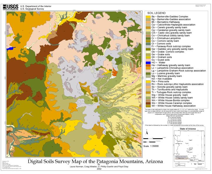
| Ba | Barkerville-Gaddes Complex -- Gravelly sandy loam and sandy clay loam |
| Bg | Barkerville-Gaddes Association -- Gravelly sandy loam and sandy clay loam |
| Bh | Bernadino-Hathaway Association -- Gravelly clay loam and cobbly sandy loam |
| Ca | Calciorthids-Haplargids Association -- Properties too variable to be estimated |
| Cb | Canelo Gravelly Sandy Loam -- Gravelly, very gravelly, or cobbly sandy loam |
| Cg | Caralampi Gravelly Sandy Loam -- Gravelly sandy loam and very gravelly sandy clay loam |
| Cm | Casto Very Gravelly Sandy Loam -- Gravelly and very gravelly sandy clay loam |
| Co | Chiricahua Cobbly Sandy Loam -- Cobbly or gravelly heavy clay loam or clay |
| Cr | Chiricahua- Lampshire Association -- Cobbly or gravelly heavy clay loam or clay |
| Cs | Comoro Sandy Loam -- Sandy loam and gravelly sandy loam |
| Ct | Comoro Soils -- Sandy loam and gravelly sandy loam |
| Fr | Faraway- Rock Outcrop Complex -- Very cobbly fine sandy loam |
| Ga | Gaddes Very Gravelly Sandy Loam -- Gravelly sandy loam, sandy loam, sandy clay loam, gravelly clay, and cobbly sandy clay loam |
| Gb | Grabe- Comoro Complex -- Loam and sandy loam |
| Ge | Grabe Soils -- Loam and sandy loam |
| Gh | Graham Soils -- Very cobbly clay loam and clay |
| Gu | Guest Soils -- Clay, gravelly clay and gravelly clay loam |
| HO | Water Bodies |
| Ha | Hathaway Gravelly Sandy Loam -- Gravelly sandy clay loam, gravelly and very gravelly sandy loam, and sandy loam |
| Lc | Lampshire-Chiricahua Association -- Very cobbly loam |
| Lg | Lampshire- Graham- Rock Outcrop Association -- Very cobbly loam |
| Lu | Luzena Gravelly Loam, Deep Variant -- Gravelly clay loam and gravelly clay |
| Mg | Martinez Gravelly Loam -- Loam or clay loam and clay |
| NA | Not Available Undefined soil type |
| Pm | Pima Soils -- Clay loam |
| Rn | Rock Outcrop- Lithic Haplustolls Association Properties too variable to be estimated |
| So | Sonoita Gravelly Sandy Loam -- Gravelly sandy loam |
| Th | Torrifluvents and Haplustoils -- Properties too variable to be estimated |
| Tr | Tortugas- Rock Outcrop Complex -- Very cobbly loam |
| Wg | White House Gravelly Loam -- Gravelly loam, clay loam, and clay |
| Wh | White House Cobbly Sandy Loam -- Gravelly loam, clay loam, and clay |
| Wn | White House- Bonita Complex -- Gravelly loam, clay loam, and clay |
| Wo | White House- Caralampi Complex -- Gravelly loam, clay loam, and clay |
| Wt | White House- Hathaway Association -- Gravelly loam, clay loam, and clay |
| Value | Definition |
|---|---|
| B | 0-5 percent slopes |
| C | 1-10 percent slopes |
| D | 0-20 percent slopes |
| E | 20-40 percent slopes |
| F | 1 -- 60 percent slopes |
| Value | Definition |
|---|---|
| 0 | not considered eroded at the time of the survey |
| 2 | eroded at the time of the survey |
Coauthors helped to generate the final product map and ArcInfo coverage. Craig Wissler, professor at the University of Arizona, oversaw the automation and attribution of the actual data, while D.P. Guertin, also a professor at the University of Arizona, helped in assessing the final product and its further applications. Floyd Gray, geologist at the USGS, hired the work to be done as part of a 5-year project investigation of the fate and transport of minerals in the Patagonia Mountains in association with abandoned mine locations. Karen Bolm, also of the USGS, helped tremendously in the review of digital and manuscript data.
Beginning in March of 1997, the Preliminary Assessment of the Patagonia Mountains study area was undertaken. An integrated watershed analysis using Geographic Information Systems (GIS) based platform was undertaken to examine transport characteristics. The Universal Soil Loss Equation (USLE) and the Spatially Explicit Delivery MODel (SEDMOD) were chosen to assist in characterization of potential point and nonpoint source material yield within selected drainage systems.
This was done to provide information useful for defining areas of significant environmental impact and to shed some light on the most practical remediation strategies to be employed. Many studies have been conducted to determine different parameters, effects and contributions of human activity in the Patagonia and southern Santa Rita Mountains study area. Incorporation to a digital data model required acquisition of accurate geo-spatial digital soils data. This digital geospatial database is one of many being created by the U.S. Geological Survey as an ongoing effort to provide geologic information in a geographic information system (GIS) for use in spatial analysis.
Are there legal restrictions on access or use of the data?Access_Constraints: none
Use_Constraints:Anyone who uses these data must cite USGS. These data are not to be used at scales greater than 1:20,000.
The U.S. Geological Survey (USGS) provides these geographic data "as is." The USGS makes no guarantee or warranty concerning the accuracy of information contained in the geographic data. The USGS further makes no warranties, either expressed or implied, as to any other matter whatsoever, including, but without limitation to, the condition of the product of its fitness for any particular purpose. The burden for determining fitness for use lies entirely with the user. Although these data have been processed successfully on computers with USGS, no warranty, expressed or implied, is made by the USGS regarding the use of these data on any other system, nor does the fact of distribution constitute or imply such warranty.
In no event shall the USGS have any liability whatsoever for payment of any consequential, incidental, indirect, special, or tort damages of any kind, including, but not limited to, any loss of profits arising out of use of or reliance on the geographical data or arising out of the delivery, installation operation, or support by USGS.
The digital geologic map GIS of the Patagonia Mountains area in Arizona is not meant to be used or displayed at any scale larger than 1:20,000 (for example, 1:12,000).
| Data format: | Soil units in format ARCE (version 7.2.1) Size: 3.5 |
|---|---|
| Network links: |
http://pubs.usgs.gov/of/2002/0324/scs_soil.e00 |