Citation:
Citation_Information:
Originator: Labay, K.A.
Originator: Haeussler, P.J.
Publication_Date: 2001
Title:
GIS Coverages of the Castle Mountain Fault, South Central Alaska
Edition: Version 1.0
Geospatial_Data_Presentation_Form: vector digital data
Series_Information:
Series_Name: U.S. Geological Survey Open-File Report
Issue_Identification: 01-504
Online_Linkage: http://pubs.usgs.gov/of/2001/of01-504/
Description:
Abstract:
This data set represents GIS coverages of the Castle Mountain
Fault captured from three maps representing portions of the fault
in south central Alaska.
Purpose:
Provide land managers with an authoritative source for the location
of the fault in the Talkeetna Mountains and Susitna Lowland.
Digital maps may be displayed at any scale or projection,
however the geologic data in this coverage is not intended for use
at a scale larger than 1:63,360.
Time_Period_of_Content:
Time_Period_Information:
Single_Date/Time:
Calendar_Date: 2001
Currentness_Reference: publication date
Status:
Progress: Complete
Maintenance_and_Update_Frequency: None planned
Spatial_Domain:
Bounding_Coordinates:
West_Bounding_Coordinate: -150.75
East_Bounding_Coordinate: -147.75
North_Bounding_Coordinate: 62.00
South_Bounding_Coordinate: 61.25
Keywords:
Theme:
Theme_Keyword_Thesaurus: USGS Thesaurus
Theme_Keyword: geology
Theme_Keyword: geologic maps
Theme_Keyword: geologic structure
Theme_Keyword: faulting (geologic)
Theme_Keyword: geospatial datasets
Theme:
Theme_Keyword_Thesaurus: ISO 19115 Topic Categories
Theme_Keyword: geoscientificInformation
Place:
Place_Keyword_Thesaurus: none
Place_Keyword: Alaska
Place_Keyword: south central
Place_Keyword: Castle Mountain
Place_Keyword: Matanuska Valley
Place_Keyword: Talkeetna Mountains
Place_Keyword: Susitna lowland
Place:
Place_Keyword_Thesaurus: Augmented FIPS 10-4 and FIPS 6-4
Place_Keyword: f02170 = Matanuska-Susitna
Access_Constraints: None
Use_Constraints:
Acknowledgement of the U.S. Geological Survey would be appreciated
in products derived from this data.
Point_of_Contact:
Contact_Information:
Contact_Organization_Primary:
Contact_Organization: U.S. Geological Survey
Contact_Person: Peter J. Haeussler
Contact_Position: Geologist
Contact_Address:
Address_Type: mailing and physical address
Address: 4200 University Drive
City: Anchorage
State_or_Province: AK
Postal_Code: 99508-4667
Country: USA
Contact_Voice_Telephone: 907-786-7447
Contact_Electronic_Mail_Address: [email protected]
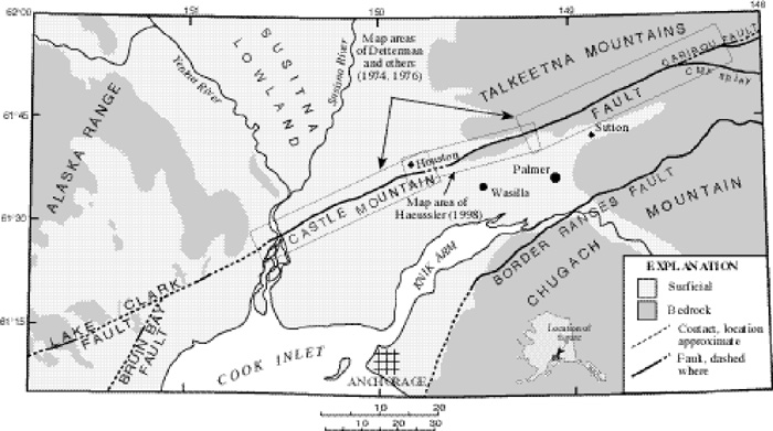
Browse_Graphic:
Browse_Graphic_File_Name: http://pubs.usgs.gov/of/2001/of01-504/images/map.jpg
Browse_Graphic_File_Description:
Index map showing the extent of the geologic map within south central Alaska, 700x391 pixels, 32-bit RGB true color, 96 kbytes.
Browse_Graphic_File_Type: JPEG
Data_Set_Credit: GIS support by Keith A. Labay Raytheon ITSS contractor.
Native_Data_Set_Environment:
Data set was created using ESRI ARC/Info version 7.2.1 on a
Unix platform.