Citation:
Citation_Information:
Originator: Douglas M. Morton
Originator: Brett F. Cox
Publication_Date: 2001
Title:
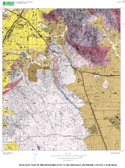
Geologic Map of the Riverside East 7.5' Quadrangle, Riverside County, California
Edition: (Version 1.0, October 03, 2001)
Geospatial_Data_Presentation_Form: vector digital data
Series_Information:
Series_Name: U.S. Geological Survey Open-File Report
Issue_Identification: 01-452
Publication_Information:
Publication_Place: Menlo Park, California
Publisher: U.S. Geological Survey
Online_Linkage: http://pubs.usgs.gov/of/2001/0452/
Description:
Abstract:
This data set maps and describes the geology of the Riverside East 7.5' quadrangle, Riverside County, California. Created using Environmental Systems Research Institute's ARC/INFO software, the data base consists of the following items: (1) a map coverage containing geologic contacts and units, (2) a coverage containing structural data, (3) a coverage containing geologic unit annotation and leaders, and (4) attribute tables for geologic units (polygons), contacts (arcs), and site-specific data (points). In addition, the data set includes the following graphic and text products: (1) a postscript graphic plot-file containing the geologic map, topography, cultural data, a Correlation of Map Units (CMU) diagram, a Description of Map Units (DMU), and a key for point and line symbols, and (2) PDF files of the Readme (including the metadata file as an appendix), and the graphic produced by the Postscript plot file.
The Riverside East quadrangle is located in the northern part of the Peninsular Ranges Province within the central part of the Perris block, a relatively stable, rectangular in plan area located between the Elsinore and San Jacinto fault zones.
The quadrangle is underlain predominantly by Cretaceous plutonic rocks which are part of the composite Peninsular Ranges batholith. Within the quadrangle, the batholithic rocks represent a wide variety of mafic to intermediate composition granitic rocks ranging in composition from monzogranite to gabbro, but tonalite predominates. Most of the granitic rocks are faintly to intensely foliated. Many are heterogenous and contain varying amounts of meso-and melanocratic discoidal-shaped inclusions. Some rock is composed almost wholly of inclusion material and some are migmatitic. Included within these granitic rocks are a few septa of Paleozoic(?) biotite schist, marble, and calcsilicate rock of upper amphibolite metamorphic grade.
Metamorphic rocks of Paleozoic(?) age occur primarily in the northwest part of the quadrangle. These rocks include coarse-grained marble bodies that have been quarried in the past. North Hill, at the northwest corner of the quadrangle is the site of the 'Old City' quarry, where tonalite intrudes marble producing pyroxene-hornfels grade garnet-pyroxene skarn. South of Riverside several disconnected bodies of marble, impure quartzite, and calcsilicate rock were quarried at the 'New City' (Victoria Ave) quarry. There, the thicker of the two marble bodies was quarried exposing skarn developed at a contact between the marble and intrusive biotite-hornblende tonalite. The composition of the skarn is highly varied and includes pyroxene-grarnet, idocrase, scapolite-pyroxene, and magnetite-pageite skarns.
Biotite-hornblende tonalite of the relatively large Val Verde pluton dominates the quadrangle west of Interstate 215. In most places this tonalite has a northwest oriented crude to well developed planar fabric produced by oriented biotite and hornblende. In the northern part of the pluton northeast striking planar fabric dominates. Schlieren and massive clots of mafic tonalite occur locally. Discoidal-to pancake-shaped mafic inclusions are widespread and are oriented in the plane of the biotite and hornblende. Typically, the planar fabric dips moderately to the northeast, but is locally horizontal to subhorizontal or grades to an isotropic fabric.
Granitic rocks in the northeastern part of the quadrangle are part of the Box Springs plutonic complex. This composite intrusion is an elliptical, flat-floored granitic complex centered on the Box Springs Mountains. The exposed part of the complex is apparently the lower part of a granitic diapir. In the center of the complex massive to indistinctly primarily layered biotite tonalite grades outward into well foliated biotite tonalite. Further outward the rocks are a heterogeneous assemblage of primarily granodioritic plutonic rocks.
The geologic map data base contains original U.S. Geological Survey data generated by detailed field observation recorded on 1:24,000 scale aerial photographs. The map was created by transferring lines from the aerial photographs to a 1:24,000 scale topographic base. The map was digitized and lines, points, and polygons were subsequently edited using standard ARC/INFO commands. Digitizing and editing artifacts significant enough to display at a scale of 1:24,000 were corrected. Within the database, geologic contacts are represented as lines (arcs), geologic units are polygons, and site-specific data as points. Polygon, arc, and point attribute tables (.pat, .aat, and .pat, respectively) uniquely identify each geologic datum.
Purpose:
The data set for the Riverside East 7.5' quadrangle was prepared under the U.S. Geological Survey Southern California Areal Mapping Project (SCAMP) as part of an ongoing effort to develop a regional geologic framework of southern California, and to utilize a Geographic Information System (GIS) format to create regional digital geologic databases. These regional databases are being developed as contributions to the National Geologic Map Database of the National Cooperative Geologic Mapping Program of the USGS.
Time_Period_of_Content:
Time_Period_Information:
Single_Date/Time:
Calendar_Date: 2001
Currentness_Reference: New data obtained
Status:
Progress: Complete
Maintenance_and_Update_Frequency: As Needed
Spatial_Domain:
Bounding_Coordinates:
West_Bounding_Coordinate: -117.3750914
East_Bounding_Coordinate: -117.2499086
North_Bounding_Coordinate: 33.99999995
South_Bounding_Coordinate: 33.87498415
Keywords:
Theme:
Theme_Keyword_Thesaurus: USGS Thesaurus
Theme_Keyword: geology
Theme_Keyword: geologic maps
Theme_Keyword: geologic structure
Theme_Keyword: bedrock geologic units
Theme_Keyword: surficial geologic units
Theme_Keyword: geospatial datasets
Theme:
Theme_Keyword_Thesaurus: ISO 19115 Topic Categories
Theme_Keyword: geoscientificInformation
Place:
Place_Keyword_Thesaurus: none
Place_Keyword: California
Place_Keyword: Riverside County
Place_Keyword: Riverside East 7.5' quadrangle
Place:
Place_Keyword_Thesaurus: Augmented FIPS 10-4 and FIPS 6-4
Place_Keyword: f06065 = Riverside
Stratum:
Stratum_Keyword_Thesaurus: None
Stratum_Keyword: Cretaceous tonalite and granodiorite
Stratum_Keyword: Quaternary deposits
Temporal:
Temporal_Keyword_Thesaurus: None
Temporal_Keyword: Cretaceous
Temporal_Keyword: Quaternary
Access_Constraints: None
Use_Constraints:
The Riverside East 7.5' geologic-map database should be used to evaluate and understand the geologic character of the Riverside East 7.5' quadrangle as a whole. The data should not be used for purposes of site-specific land-use planning or site-specific geologic evaluations. The database is sufficiently detailed to identify and characterize many actual and potential geologic hazards represented by faults and landslides and posed by ground subsidence and earthquake-generated ground shaking. However, it is not sufficiently detailed for site-specific determinations or evaluations of these features. Faults shown do not take the place of fault-rupture hazard zones designated by the California State Geologist (see Hart, 1988).
Use of this digital geologic-map database should not violate the spatial resolution of the data. Although the digital form of the data removes the constraint imposed by the scale of a paper map, the detail and accuracy inherent in map scale are also present in the digital data. The fact that this database was compiled and edited at a scale of 1:24,000 means that higher resolution information may not have been uniformly retained in the dataset. Plotting at scales larger than 1:24,000 will not yield greater real detail, although it may reveal fine-scale irregularities below the intended resolution of the database. Similarly, although higher resolution data is incorporated in most of the map, the resolution of the combined output will be limited by the lower resolution data.
Point_of_Contact:
Contact_Information:
Contact_Person_Primary:
Contact_Person: Douglas M Morton
Contact_Organization: U.S. Geological Survey, GEO-WRG-NGM
Contact_Address:
Address_Type: mailing address
Address: UC - Riverside
City: Riverside
State_or_Province: CA
Postal_Code: 92521
Country: USA
Contact_Voice_Telephone: 909-276-6397
Contact_Facsimile_Telephone: 909-276-6295
Contact_Electronic_Mail_Address: [email protected]
Browse_Graphic:
Browse_Graphic:
Data_Set_Credit:
Geologic mapping and digital preparation of this report were sponsored jointly by (1) the National Cooperative Geologic Mapping Program of the U.S. Geological Survey, (2) the California Division of Mines and Geology, (3) the Southern California Areal Mapping Project (SCAMP), and (4) the U.S. Air Force.
Native_Data_Set_Environment:
SunOS, 5.8, sun4m UNIX
ARC/INFO version 7.2.1
Cross_Reference:
Citation_Information:
Originator: Morton, D.M.
Publication_Date: 1999
Title:
Preliminary digital geologic map of the Santa Ana 30'x60' quadrangle, southern California, version 1.0.
Geospatial_Data_Presentation_Form: vector digital data
Series_Information:
Series_Name: U.S. Geological Survey Open-File Report
Issue_Identification: 99-172
Publication_Information:
Publication_Place: California
Publisher: U.S. Geological Survey
Online_Linkage: http://pubs.usgs.gov/of/1999/of99-172/