Citation:
Citation_Information:
Originator: Douglas M. Morton
Originator: Brett F. Cox
Publication_Date: 2001
Title:
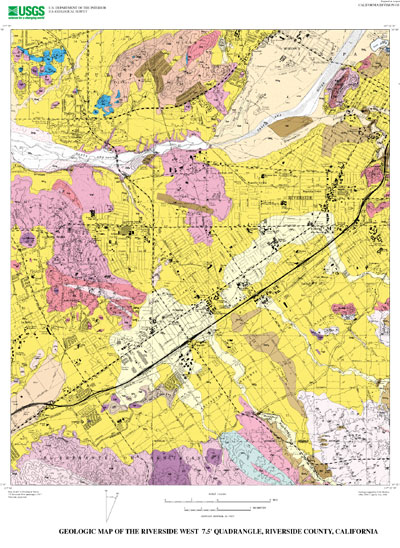
Geologic Map of the Riverside West 7.5' Quadrangle, Riverside County, California
Edition: Version 1.0
Geospatial_Data_Presentation_Form: vector digital data
Series_Information:
Series_Name: U.S. Geological Survey Open-File Report
Issue_Identification: 01-451
Publication_Information:
Publication_Place: Menlo Park, California
Publisher: U.S. Geological Survey
Online_Linkage: http://pubs.usgs.gov/of/2001/0451/
Description:
Abstract:
This data set maps and describes the geology of the Riverside West 7.5' quadrangle, Riverside County, California. Created using Environmental Systems Research Institute's ARC/INFO software, the data base consists of the following items: (1) a map coverage containing geologic contacts and units, (2) a coverage containing structural data, (3) a coverage containing geologic unit annotation and leaders, and (4) attribute tables for geologic units (polygons), contacts (arcs), and site-specific data (points). In addition, the data set includes the following graphic and text products: (1) a postscript graphic plot-file containing the geologic map, topography, cultural data, a Correlation of Map Units (CMU) diagram, a Description of Map Units (DMU), and a key for point and line symbols, and (2) PDF files of the Readme (including the metadata file as an appendix), and the graphic produced by the Postscript plot file.
The Riverside West quadrangle is located in the northern part of the Perris block, a relatively stable, rectangular-in-plan area located between the Elsinore and San Jacinto fault zones in the northern Peninsular Ranges Province.
Most of the quadrangle is covered by a variable thickness of Quaternary alluvial material deposited on Cretaceous and older basement rocks. In the southern part of the quadrangle, northwest trending amphibolite grade biotite-bearing schist of Mesozoic or older age separates massive textured granitic rocks to the west from foliated and layered granitic rocks to the east. In the northern part of the quadrangle, scattered exposures of amphibolite grade biotite schist, impure quartzite, marble, calc-silicate rock, and skarn are probably Paleozoic. In the northeast corner of the quadrangle probable Paleozoic marble, which was quarried for local use, is intruded by tonalite, producing pyroxene-hornfels grade garnet-pyroxene skarn.
The wide variety of mafic to silicic Cretaceous plutonic rocks in the quadrangle, are part of the composite Peninsular Ranges batholith. Hornblende and pyroxene gabbro, oldest of the plutonic rocks, occurs as a number of scattered small bodies. The relatively large gabbro body located at the south edge of the quadrangle extends for some distance south into the Lake Mathews quadrangle. On both sides of this body, the granodiorite of the Cajalco pluton contains numerous stoped masses of gabbro. Most of the granitic rock in the quadrangle is tonalitic with a faint to pronounced planar fabric produced by oriented biotite and hornblende. This planar structure in the northern two-thirds of the quadrangle typically strikes east, distinct from the northwest strike of planar structures common to most of the Peninsular Ranges batholith. The northwest part of the extensive, relatively uniform medium-to coarse-grained biotite-hornblende tonalite the Val Verde pluton underlies the southeast corner of the quadrangle. Relatively mafic hornblende and biotite-hornblende quartz diorite occurs in the central part of the quadrangle, and heterogeneous tonalite underlies most of the Pedley Hills in the north part of the quadrangle. In the southwestern part of the quadrangle, the northeastern extent of the lesser amounts of biotite-hornblende granodiorite. Common to this part of the Cajalco pluton are concentrated large and small stoped blocks of gabbro, most too small to be mapped at 1:24,000-scale. Numerous, massive to foliated, leucocratic biotite granite bodies are scattered thoughout the quadrangle. At Mount Rubidoux, very distinctive, dark colored, massive, coarse-grained granite contains hypersthene and fayalitic olivine in addition to biotite and hornblende.
Located along the southwest boundary of the quadrangle is a very small occurrence of Paleocene? conglomerate that consists of exotic welded-tuff clasts and a few exotic bedded quartzite clasts. Several small areas of late Pliocene or early Pleistocene, slightly indurated fluvial sand, gravel, and cobbles occur in the Arlington area. Clasts in the deposits north of State Highway 91 consist entirely of San Bernardino Mountains lithologies. The deposits south of State Highway 91 consist of an upper section composed of slightly indurated bouldery gravel and sand derived from nearby Peninsular Ranges basement rocks and a lower section composed of clasts of San Bernardino Mountains lithologies. The patches of sediments containing San Bernardino Mountains lithologies are interpreted as being erosional remanants of paleo-Santa Ana River deposits, deposited when the river course was further south than its present day course.
Most of the lower elevation areas of the quadrangle are covered by Pleistocene alluvial fan deposits. These fans were graded to the location of the present day course of the Santa Ana River but at a slightly higher elevation than the elevation of the present day river grade.
The eastern part of the Santa Ana River includes a relatively broad young fluvial expanse and the western part is a relatively narrow alluvial channel incised into bedrock.
The geologic map data base contains original U.S. Geological Survey data generated by detailed field observation recorded on 1:24,000 scale aerial photographs. The map was created by transferring lines from the aerial photographs to a 1:24,000 scale topographic base. The map was digitized and lines, points, and polygons were subsequently edited using standard ARC/INFO commands. Digitizing and editing artifacts significant enough to display at a scale of 1:24,000 were corrected. Within the database, geologic contacts are represented as lines (arcs), geologic units are polygons, and site-specific data as points. Polygon, arc, and point attribute tables (.pat, .aat, and .pat, respectively) uniquely identify each geologic datum.
Purpose:
The data set for the Riverside West 7.5' quadrangle was prepared under the U.S. Geological Survey Southern California Areal Mapping Project (SCAMP) as part of an ongoing effort to develop a regional geologic framework of southern California, and to utilize a Geographic Information System (GIS) format to create regional digital geologic databases. These regional databases are being developed as contributions to the National Geologic Map Database of the National Cooperative Geologic Mapping Program of the USGS.
Time_Period_of_Content:
Time_Period_Information:
Single_Date/Time:
Calendar_Date: 2001
Currentness_Reference: New data obtained
Status:
Progress: Complete
Maintenance_and_Update_Frequency: As Needed
Spatial_Domain:
Bounding_Coordinates:
West_Bounding_Coordinate: -117.5000914
East_Bounding_Coordinate: -117.3749086
North_Bounding_Coordinate: 34.00000046
South_Bounding_Coordinate: 33.87498306
Keywords:
Theme:
Theme_Keyword_Thesaurus: USGS Thesaurus
Theme_Keyword: geology
Theme_Keyword: geologic maps
Theme_Keyword: geologic structure
Theme_Keyword: bedrock geologic units
Theme_Keyword: surficial geologic units
Theme_Keyword: geospatial datasets
Theme:
Theme_Keyword_Thesaurus: ISO 19115 Topic Categories
Theme_Keyword: geoscientificInformation
Place:
Place_Keyword_Thesaurus: none
Place_Keyword: California
Place_Keyword: Riverside County
Place_Keyword: Riverside West 7.5' quadrangle
Place:
Place_Keyword_Thesaurus: Augmented FIPS 10-4 and FIPS 6-4
Place_Keyword: f06065 = Riverside
Stratum:
Stratum_Keyword_Thesaurus: None
Stratum_Keyword: Cretaceous tonalite and granodiorite
Stratum_Keyword: Quaternary deposits
Temporal:
Temporal_Keyword_Thesaurus: None
Temporal_Keyword: Cretaceous
Temporal_Keyword: Quaternary
Access_Constraints: None
Use_Constraints:
The Riverside West 7.5' geologic-map database should be used to evaluate and understand the geologic character of the Riverside West 7.5' quadrangle as a whole. The data should not be used for purposes of site-specific land-use planning or site-specific geologic evaluations. The database is sufficiently detailed to identify and characterize many actual and potential geologic hazards represented by faults and landslides and posed by ground subsidence and earthquake-generated ground shaking. However, it is not sufficiently detailed for site-specific determinations or evaluations of these features. Faults shown do not take the place of fault-rupture hazard zones designated by the California State Geologist (see Hart, 1988).
Use of this digital geologic-map database should not violate the spatial resolution of the data. Although the digital form of the data removes the constraint imposed by the scale of a paper map, the detail and accuracy inherent in map scale are also present in the digital data. The fact that this database was compiled and edited at a scale of 1:24,000 means that higher resolution information may not have been uniformly retained in the dataset. Plotting at scales larger than 1:24,000 will not yield greater real detail, although it may reveal fine-scale irregularities below the intended resolution of the database. Similarly, although higher resolution data is incorporated in most of the map, the resolution of the combined output will be limited by the lower resolution data.
Point_of_Contact:
Contact_Information:
Contact_Person_Primary:
Contact_Person: Douglas M Morton
Contact_Organization: U.S. Geological Survey, GEO-WRG-NGM
Contact_Address:
Address_Type: mailing address
Address: UC - Riverside
City: Riverside
State_or_Province: CA
Postal_Code: 92521
Country: USA
Contact_Voice_Telephone: 909-276-6397
Contact_Facsimile_Telephone: 909-276-6295
Contact_Electronic_Mail_Address: [email protected]
Browse_Graphic:
Browse_Graphic:
Data_Set_Credit:
Geologic mapping and digital preparation of this report were sponsored jointly by (1) the National Cooperative Geologic Mapping Program of the U.S. Geological Survey, (2) the California Division of Mines and Geology, and (3) the Southern California Areal Mapping Project (SCAMP).
Native_Data_Set_Environment:
SunOS, 5.8, sun4m UNIX
ARC/INFO version 7.2.1
Cross_Reference:
Citation_Information:
Originator: Morton, D.M.
Publication_Date: 1999
Title:
Preliminary digital geologic map of the Santa Ana 30'x60' quadrangle, southern California, version 1.0.
Geospatial_Data_Presentation_Form: vector digital data
Series_Information:
Series_Name: U.S. Geological Survey Open-File Report
Issue_Identification: 99-172
Publication_Information:
Publication_Place: California
Publisher: U.S. Geological Survey
Online_Linkage: http://pubs.usgs.gov/of/1999/of99-172/