Citation:
Citation_Information:
Originator: Douglas M. Morton
Publication_Date: 2001
Title:
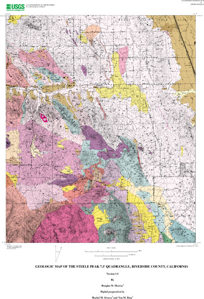
Geologic Map of the Steele Peak 7.5' Quadrangle, Riverside County, California
Edition: Version 1.0
Geospatial_Data_Presentation_Form: vector digital data
Series_Information:
Series_Name: U.S. Geological Survey Open-File Report
Issue_Identification: 01-449
Publication_Information:
Publication_Place: Menlo Park, California
Publisher: U.S. Geological Survey
Online_Linkage: http://pubs.usgs.gov/of/2001/0449/
Description:
Abstract:
This data set maps and describes the geology of the Steele Peak 7.5' quadrangle, Riverside County, California. Created using Environmental Systems Research Institute's ARC/INFO software, the data base consists of the following items: (1) a map coverage containing geologic contacts and units, (2) a coverage containing structural data, (3) a coverage containing geologic unit annotation and leaders, and (4) attribute tables for geologic units (polygons), contacts (arcs), and site-specific data (points). In addition, the data set includes the following graphic and text products: (1) a postscript graphic plot-file containing the geologic map, topography, cultural data, a Correlation of Map Units (CMU) diagram, a Description of Map Units (DMU), and a key for point and line symbols, and (2) PDF files of the Readme (including the metadata file as an appendix), and the graphic produced by the Postscript plot file.
The Steele Peak quadrangle is located in the northern part of the Peninsular Ranges Province within the central part of the Perris block, a relatively stable, rectangular in plan area located between the Elsinore and San Jacinto fault zones.
The quadrangle is underlain by Cretaceous and older basement rocks. Cretaceous plutonic rocks are part of the composite Peninsular Ranges batholith. A wide variety of mafic to intermediate composition granitic rocks occur in the quadrangle, and are mainly of tonalitic composition, but range from monzogranite to gabbro. Most rock units are faintly to intensely foliated, compositionally heterogenous, and contain varying amounts of meso-and melanocratic discoidal-shaped inclusions. Some rocks are composed almost wholly of inclusion material and some are migmatitic. Included within these granitic rocks are septa not shown on the geologic map of Paleozoic(?) schist of upper amphibolite metamorphic grade.
Metamorphic rocks of primarily Mesozoic age occur in a discontinuous belt extending from the southeast to the northwest corner of the quadrangle. Most of these rocks are well foliated biotite-bearing schist. Near the southern edge of the quadrangle phyllitic rocks dominate. Northwestward, metamorphism increases from greenschist or sub-greenschist grade near the south edge of the quadrangle to sillimanite-bearing schist of upper amphibolite grade in the vicinity of Cajalco Road.
Biotite-hornblende tonalite of the relatively large Val Verde pluton dominates the northeastern half of the quadrangle. In most places this tonalite has a northwest oriented crude to well developed planar fabric produced by oriented biotite and hornblende. Schlieren and massive clots of mafic tonalite locally occur. Discoidal- to pancake-shaped mafic inclusions are widespread and are oriented in the plane defined by the biotite and hornblende. This planar fabric typically dips moderately to the northeast, but locally shallows to a horizontal to subhorizontal planar fabric, or fades to an isotropic fabric.
West of the Val Verde pluton are a number of plutons having fabrics ranging from massive isotropic to foliated. Compositions of these plutons range from monzogranite to pyroxene gabbro. Most of these granitic rocks fall within the composition range from monzogranite to tonalite, and are part of the composite Gavilan ring complex. Hypersthene is a characteristic mineral of most of the rocks of this complex, which includes black hypersthene-bearing monzogranite that has been quarried as a source of 'black granite' building stone. Several inactive gold mines, e.g., Goodhope, Gavilan, and Santa Rosa mines that constituted the Pinacate mining district, are located in the Gavilan ring complex.
In the center of the Gavilan ring complex is the near circular Arroyo del Toro pluton, a massive-textured granodiorite essentially devoid of inclusions. Only the northern half of this pluton is located in the quadrangle. Some rock of this pluton was quarried for building stone. The southwestern corner of the quadrangle is underlain by siliceous volcanic and volcanoclastic rock considered to be coeval with the batholith and be the supra-part of the batholithic magmatism. Most of these volcanic rocks range in composition from rhyolite to andesite with latitic composition rocks predominating.
In the northeastern part of the quadrangle is the proximal parts of a Pleistocene alluvial fan complex.
The geologic map data base contains original U.S. Geological Survey data generated by detailed field observation recorded on 1:24,000 scale aerial photographs. The map was created by transferring lines from the aerial photographs to a 1:24,000 scale topographic base. The map was digitized and lines, points, and polygons were subsequently edited using standard ARC/INFO commands. Digitizing and editing artifacts significant enough to display at a scale of 1:24,000 were corrected. Within the database, geologic contacts are represented as lines (arcs), geologic units are polygons, and site-specific data as points. Polygon, arc, and point attribute tables (.pat, .aat, and .pat, respectively) uniquely identify each geologic datum.
Purpose:
The data set for the Steele Peak 7.5' quadrangle was prepared under the U.S. Geological Survey Southern California Areal Mapping Project (SCAMP) as part of an ongoing effort to develop a regional geologic framework of southern California, and to utilize a Geographic Information System (GIS) format to create regional digital geologic databases. These regional databases are being developed as contributions to the National Geologic Map Database of the National Cooperative Geologic Mapping Program of the USGS.
Time_Period_of_Content:
Time_Period_Information:
Single_Date/Time:
Calendar_Date: 2001
Currentness_Reference: New data obtained
Status:
Progress: Complete
Maintenance_and_Update_Frequency: As Needed
Spatial_Domain:
Bounding_Coordinates:
West_Bounding_Coordinate: -117.37509096
East_Bounding_Coordinate: -117.24990904
North_Bounding_Coordinate: 33.87499995
South_Bounding_Coordinate: 33.74998418
Keywords:
Theme:
Theme_Keyword_Thesaurus: USGS Thesaurus
Theme_Keyword: geology
Theme_Keyword: geologic maps
Theme_Keyword: geologic structure
Theme_Keyword: bedrock geologic units
Theme_Keyword: surficial geologic units
Theme_Keyword: geospatial datasets
Theme:
Theme_Keyword_Thesaurus: ISO 19115 Topic Categories
Theme_Keyword: geoscientificInformation
Place:
Place_Keyword_Thesaurus: none
Place_Keyword: California
Place_Keyword: Riverside County
Place_Keyword: Steele Peak 7.5' quadrangle
Place:
Place_Keyword_Thesaurus: Augmented FIPS 10-4 and FIPS 6-4
Place_Keyword: f06065 = Riverside
Stratum:
Stratum_Keyword_Thesaurus: None
Stratum_Keyword: Cretaceous tonalite and granodiorite
Stratum_Keyword: Cretaceous volcanics
Temporal:
Temporal_Keyword_Thesaurus: None
Temporal_Keyword: Cretaceous
Access_Constraints: None
Use_Constraints:
The Steele Peak 7.5' geologic-map database should be used to evaluate and understand the geologic character of the Steele Peak 7.5' quadrangle as a whole. The data should not be used for purposes of site-specific land-use planning or site-specific geologic evaluations. The database is sufficiently detailed to identify and characterize many actual and potential geologic hazards represented by faults and landslides and posed by ground subsidence and earthquake-generated ground shaking. However, it is not sufficiently detailed for site-specific determinations or evaluations of these features. Faults shown do not take the place of fault-rupture hazard zones designated by the California State Geologist (see Hart, 1988).
Use of this digital geologic-map database should not violate the spatial resolution of the data. Although the digital form of the data removes the constraint imposed by the scale of a paper map, the detail and accuracy inherent in map scale are also present in the digital data. The fact that this database was compiled and edited at a scale of 1:24,000 means that higher resolution information may not have been uniformly retained in the dataset. Plotting at scales larger than 1:24,000 will not yield greater real detail, although it may reveal fine-scale irregularities below the intended resolution of the database. Similarly, although higher resolution data is incorporated in most of the map, the resolution of the combined output will be limited by the lower resolution data.
Point_of_Contact:
Contact_Information:
Contact_Person_Primary:
Contact_Person: Douglas M Morton
Contact_Organization: U.S. Geological Survey, GEO-WRG-NGM
Contact_Address:
Address_Type: mailing address
Address: UC - Riverside
City: Riverside
State_or_Province: CA
Postal_Code: 92521
Country: USA
Contact_Voice_Telephone: 909-276-6397
Contact_Facsimile_Telephone: 909-276-6295
Contact_Electronic_Mail_Address: scamp@usgs.gov
Browse_Graphic:
Browse_Graphic:
Data_Set_Credit:
Geologic mapping and digital preparation of this report were sponsored jointly by (1) the National Cooperative Geologic Mapping Program of the U.S. Geological Survey, (2) the California Division of Mines and Geology, (3) the Southern California Areal Mapping Project (SCAMP), and (4) the U.S. Air Force.
Native_Data_Set_Environment:
SunOS, 5.8, sun4m UNIX
ARC/INFO version 7.2.1
Cross_Reference:
Citation_Information:
Originator: Morton, D.M.
Publication_Date: 1999
Title:
Preliminary digital geologic map of the Santa Ana 30'x60' quadrangle, southern California, version 1.0.
Geospatial_Data_Presentation_Form: vector digital data
Series_Information:
Series_Name: U.S. Geological Survey Open-File Report
Issue_Identification: 99-172
Publication_Information:
Publication_Place: California
Publisher: U.S. Geological Survey
Online_Linkage: http://pubs.usgs.gov/of/1999/of99-172/