Citation:
Citation_Information:
Originator: Anthony J. Crone
Originator: Rex L. Baum
Originator: David J. Lidke
Originator: Damon N.D. Sather
Originator: Lee-Ann Bradley
Originator: Arthur C. Tarr
Publication_Date: 2001
Title: Older landslides (before Hurricane Mitch) in El Salvador
Geospatial_Data_Presentation_Form: vector digital data
Series_Information:
Series_Name: U.S. Geological Survey Open-File Report
Issue_Identification: 01-444
Publication_Information:
Publication_Place: Denver, CO
Publisher: U.S. Geological Survey
Online_Linkage: http://pubs.usgs.gov/of/2001/ofr-01-0444/
Larger_Work_Citation:
Citation_Information:
Originator: Anthony J. Crone
Originator: Rex L. Baum
Originator: David J. Lidke
Originator: Damon N.D. Sather
Originator: Lee-Ann Bradley
Originator: Arthur C. Tarr
Publication_Date: 2001
Title:
Landslides Induced by Hurricane Mitch in El Salvador--An Inventory and Descriptions of Selected Features
Geospatial_Data_Presentation_Form: map
Series_Information:
Series_Name: U.S. Geological Survey Open-File Report
Issue_Identification: 01-444
Publication_Information:
Publication_Place: Denver, CO
Publisher: U.S. Geological Survey
Online_Linkage: http://pubs.usgs.gov/of/2001/ofr-01-0444/
Description:
Abstract:
This cover contains the outlines of selected landslides and debris flows that occurred prior to Hurricane Mitch in the areas where hurricane-induced landslides were mapped. The landslides and debris flows shown in this coverage were mapped using 1:40,00-scale and 1:15,000-scale black-and-white aerial photographs. Much of the photography was taken a few months after the storm, but additional photography was taken in late 2000. The photographs were visually examined using 4-X mirror stereoscopes, and the landslides were plotted by hand on mylar overlays that were registered to topographic maps. The landslides were plotted on 1:25,000-scale maps where these high-quality maps were available; for other parts of the country, the landslides were plotted on 1:50,000-scale maps. The plotted landslides were then manually digitized and registered to digital raster graphic (DRG) images of 1:50,000-scale topographic maps. Some of the areas in this coverage are composites of parts of two or more 12:50,000-scale quadrangles. To produce these composites, the edges of adjoining quadrangles had to be digitally adjusted in ArcInfo to assure continuity between adjacent maps. These adjustments were also necessary to resolve differences in the resolution between 1:50,000-scale and 1:25,000-scale topographic maps. After these adjustments, the areas of each plate were cut from merged DRGs and the digital landslides were then plotted on the DRG images of the map areas. The cover portrays the shapes, relative location, and size of pre-hurricane landslides and the associated downslope deposits. For those features that were originally mapped on 1:25,000-scale topographic maps, we estimate that their locations are accurate to within less than 100 m and probably to within 50m. For features that were originally mapped on 1:50,000-scale topographic maps, their locations are probably accurate to within 100-200m.
Purpose:
The coverage shows the distribution of pre-hurricane slope failures and the associated deposits selected parts of El Salvador. The cover included maps of these features in widely separated parts of the country. The maps provide an inventory of these features and also contain a few recent landslides that predate the hurricane.
Time_Period_of_Content:
Time_Period_Information:
Single_Date/Time:
Calendar_Date: 200112
Currentness_Reference: publication date
Status:
Progress: Complete
Maintenance_and_Update_Frequency: None planned
Spatial_Domain:
Bounding_Coordinates:
West_Bounding_Coordinate: -88.858421
East_Bounding_Coordinate: -88.527321
North_Bounding_Coordinate: 14.066360
South_Bounding_Coordinate: 13.560819
Keywords:
Theme:
Theme_Keyword_Thesaurus: USGS Thesaurus
Theme_Keyword: landslides
Theme_Keyword: hurricanes
Theme_Keyword: precipitation (atmospheric)
Theme_Keyword: geospatial datasets
Theme:
Theme_Keyword_Thesaurus: none
Theme_Keyword: landslides
Theme_Keyword: Hurricane Mitch
Theme_Keyword: debris flows
Theme_Keyword: earth flows
Theme_Keyword: inventory
Theme_Keyword: rainfall
Theme_Keyword: pre-Hurricane Mitch
Theme:
Theme_Keyword_Thesaurus: ISO 19115 Topic Categories
Theme_Keyword: geoscientificInformation
Place:
Place_Keyword_Thesaurus: none
Place_Keyword: El Salvador
Place_Keyword: San Ignacio
Place_Keyword: Tejutla
Place_Keyword: Santa Ana
Place_Keyword: Ahuachapan
Place_Keyword: Berlin
Place_Keyword: San Miguel
Place_Keyword: Embalse Cerron Grande
Place_Keyword: Embalse 15 de Septiembre
Place:
Place_Keyword_Thesaurus: Augmented FIPS 10-4 and FIPS 6-4
Place_Keyword: ES = El Salvador
Access_Constraints: No access constraints
Use_Constraints: No user constraints
Point_of_Contact:
Contact_Information:
Contact_Person_Primary:
Contact_Person: Anthony J Crone
Contact_Organization: U.S. Geological Survey, CR
Contact_Address:
Address_Type: mailing address
Address:
Mail Stop 966
P.O. Box 25046
City: Lakewood
State_or_Province: CO
Postal_Code: 80225
Country: USA
Contact_Voice_Telephone: 303-273-8591
Contact_Facsimile_Telephone: 303-273-8600
Contact_Electronic_Mail_Address: [email protected]
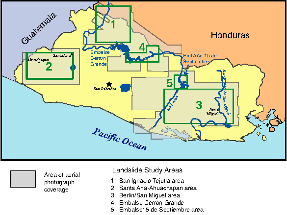
Browse_Graphic:
Browse_Graphic_File_Name:
Browse_Graphic_File_Description:
Map showing study areas and aerial photograph coverage, 585x439 pixels, 16k bytes.
Browse_Graphic_File_Type: PNG
Native_Data_Set_Environment:
Microsoft Windows NT Version 4.0 (Build 1381) Service Pack 6; ESRI ArcCatalog 8.1.1.649