Landslides triggered by Hurricane Mitch in Nicaragua

Metadata also available as - [Questions & Answers] - [Parseable text] - [XML]

Metadata:

Identification_Information:
Citation:
Citation_Information:
Originator: Susan H. Cannon
Originator: Kathleen M. Haller
Originator: Ingrid Ekstrom
Originator: Eugene S. Schweig III
Originator: Graziella Devoli
Originator: David W. Moore
Originator: Sharon A. Rafferty
Originator: Arthur C. Tarr
Publication_Date: 2001
Title: Landslides triggered by Hurricane Mitch in Nicaragua
Geospatial_Data_Presentation_Form: vector digital data
Series_Information:
Series_Name: U.S. Geological Survey Open-File Report
Issue_Identification: 01-412-A
Publication_Information:
Publication_Place: Denver, Colorado
Publisher: U.S. Geological Survey
Online_Linkage: http://pubs.usgs.gov/of/2001/ofr-01-0412-a/
Larger_Work_Citation:
Citation_Information:
Originator: Susan H. Cannon
Originator: Kathleen M. Haller
Originator: Ingrid Ekstrom
Originator: Eugene S. Schweig III
Originator: Graziella Devoli
Originator: David W. Moore
Originator: Sharon A. Rafferty
Originator: Arthur C. Tarr
Publication_Date: 2001
Title:
Landslide response to Hurricane Mitch rainfall in seven study areas in Nicaragua
Series_Information:
Series_Name: U.S. Geological Survey Open-File Report
Issue_Identification: 01-412-A
Publication_Information:
Publication_Place: Denver, Colorado
Publisher: U.S. Geological Survey
Online_Linkage: http://pubs.usgs.gov/of/2001/ofr-01-0412-a/
Description:
Abstract:
We present an inventory of landslides and related downchannel effects triggered by the passage of Hurricane Mitch, October 21-31, 1998 in seven study areas in Nicaragua. The inventory was compiled from aerial photographs and field mapping. Most (perhaps 95%) of the landslides mapped were debris flows. The maps show debris-flow source areas as small as a few square meters and only a few meters deep that produced debris flows that traveled only tens of meters downslope, to landslides that covered approximately 80,000 m2, and produced debris flows that traveled at least 3 km down channels. The remaining 5% of mapped landslides were slow-moving earthflows that started moving during Hurricane Mitch and continued to move for at least one year.
Purpose:
The passage of Hurricane Mitch through Central America in October and November 1998 caused widespread and devastating flooding and landsliding. In this data set we document the landslide and downchannel response to the rainfall that accompanied Hurricane Mitch in seven study areas in Nicaragua.
Time_Period_of_Content:
Time_Period_Information:
Single_Date/Time:
Calendar_Date: 199810
Currentness_Reference: ground condition
Status:
Progress: Complete
Maintenance_and_Update_Frequency: None planned
Spatial_Domain:
Bounding_Coordinates:
West_Bounding_Coordinate: -86.891151
East_Bounding_Coordinate: -85.779976
North_Bounding_Coordinate: 13.781092
South_Bounding_Coordinate: 12.830777
Keywords:
Theme:
Theme_Keyword_Thesaurus: USGS Thesaurus
Theme_Keyword: geology
Theme_Keyword: landslides
Theme_Keyword: hurricanes
Theme_Keyword: precipitation (atmospheric)
Theme_Keyword: geospatial datasets
Theme:
Theme_Keyword_Thesaurus: none
Theme_Keyword: Landslides
Theme_Keyword: Hurricane Mitch
Theme_Keyword: rainfall
Theme_Keyword: debris flow
Theme_Keyword: earth flow
Theme_Keyword: debris-flow susceptibility
Theme:
Theme_Keyword_Thesaurus: ISO 19115 Topic Categories
Theme_Keyword: geoscientificInformation
Place:
Place_Keyword_Thesaurus: none
Place_Keyword: Nicaragua
Place_Keyword: Departamento de Jinotega
Place_Keyword: Departamento de Leon
Place_Keyword: Departamento de Esteli
Place_Keyword: Departamento de Matagalpa
Place_Keyword: Departamento de Nueva Segovia
Place_Keyword: Departamento de Chinandega
Place:
Place_Keyword_Thesaurus: Augmented FIPS 10-4 and FIPS 6-4
Place_Keyword: NU = Nicaragua
Access_Constraints: None
Use_Constraints:
Should only be used in maps whose scale is smaller than 1:50,000.
Point_of_Contact:
Contact_Information:
Contact_Person_Primary:
Contact_Person: Susan H Cannon
Contact_Organization: U.S. Geological Survey, CR
Contact_Address:
Address_Type: mailing address
Address:
Mail Stop 966
P.O. Box 25046
City: Lakewood
State_or_Province: CO
Postal_Code: 80225
Country: USA
Contact_Voice_Telephone: 303-273-8604
Contact_Facsimile_Telephone: 303-273-8600
Contact_Electronic_Mail_Address: cannon@usgs.gov
Browse_Graphic:
Browse_Graphic_File_Name: Browse_Graphic_File_Description:
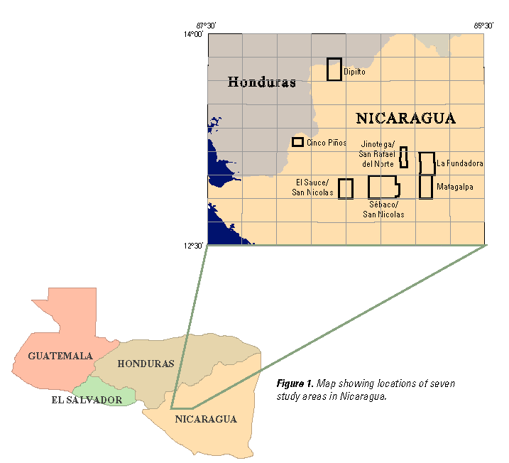
Map showing locations of study area in Nicaragua, 717x652 pixels, 14.5k bytes.
Browse_Graphic_File_Type: PNG
Native_Data_Set_Environment:
Microsoft Windows 2000 Version 5.0 (Build 2195) Service Pack 1; ESRI ArcCatalog 8.1.1.649
Cross_Reference:
Citation_Information:
Originator: Susan H. Cannon
Originator: Kathleen M. Haller
Originator: Ingrid Ekstrom
Originator: Eugene S. Schweig III
Originator: Graziella Devoli
Originator: David W. Moore
Originator: Sharon A. Rafferty
Originator: Arthur C. Tarr
Publication_Date: 2001
Title:
Respuesta a los Desprendimientos de Tierra Ocasionados por las Lluvias Torrenciales del Huracán Mitch en Siete Áreas de Estudio de Nicaragua
Series_Information:
Series_Name: U.S. Geological Survey Open-File Report
Issue_Identification: 01-412-B
Publication_Information:
Publication_Place: Denver, Colorado
Publisher: U.S. Geological Survey
Other_Citation_Details: Spanish version of 01-412-A
Online_Linkage: http://pubs.usgs.gov/of/2001/ofr-01-0412-b/
Data_Quality_Information:
Attribute_Accuracy:
Attribute_Accuracy_Report:
Attribute accuracy was assured by visually comparing compilation copy with plotted map in which the landslide styles were color coded.
Logical_Consistency_Report:
Registration accuracy was checked by inspecting plots of the data and graticule overlaid on a Digital Raster Graphic (DRG) of the base map. Topological consistency was checked by assuring that all data polygons had one label point.
Completeness_Report:
Completeness was assured by visually inspecting the compilation map overlaid on the plotted map looking for missing polygons.
Positional_Accuracy:
Horizontal_Positional_Accuracy:
Horizontal_Positional_Accuracy_Report:
The small scale of the aerial photographs used for generating the inventory, and the mapping method of manually transferring the areal extent of observed features to the base maps, dictates that the locations of the landslide features are accurate to within about 200m
Lineage:
Source_Information:
Source_Citation:
Citation_Information:
Originator: Defense Threat Reduction Agency
Geospatial_Data_Presentation_Form: aerial photographs
Source_Scale_Denominator: 60000
Type_of_Source_Media: aerial photographs
Source_Time_Period_of_Content:
Source_Currentness_Reference: ground condition
Source_Citation_Abbreviation: 1:60,000 aerial photos
Source_Information:
Source_Scale_Denominator: 30000
Type_of_Source_Media: aerial photographs
Source_Citation_Abbreviation: 1:30,000 aerial photos
Process_Step:
Process_Description:
Aerial photographs taken between December 4 and December 19, 1998 under the Open Skies program of the Defense Threat Reduction Agency were used to map the landslides shown on the maps. The aerial photographs are at 1:60,000-scale, and 1:30,000-scale for portions of the Matagalpa and Jinotega/San Rafael del Norte study areas. Digital Raster Graphics (DRG) scanned images of 1:50,000-scale quadrangles projected to Transverse Mercator were used as base maps for the mapping. We mapped landslides and related downstream effects by first identifying them on the aerial photographs using a mirror stereoscope and then manually plotting each landslide and its affected area by inspection onto the base maps. In some cases, the base maps were enlarged to 1:25,000-scale to facilitate mapping. Locations of landslides mapped using this procedure are accurate to within about 200 m.
Process_Step:
Process_Description:
Field reconnaissance from April 25 through May 6, 2000 resulted in limited verification of the landslide and related effects mapping. Because of the large areal extent of the study areas and difficulties of access, we visited only a few, small areas. We observed as few as 5% of the landslides in some study areas and as many as 40% of the landslides in others. During this reconnaissance, we mapped the locations and extents of some landslides outside the coverage of the aerial photography. This mapping represents only features that we observed, and is not representative of all the landslide activity in the area.
Process_Step:
Process_Description:
Following field verification, the mapped areal extent of landslides and affected areas were digitized, and then digitally registered to the DRG base maps. A point representing the initiation location of each landslide was also digitized. Final maps are presented at 1:50,000 scale.
Process_Step:
Process_Description: Creation of original metadata record
Process_Date: 20011205
Process_Contact:
Contact_Information:
Contact_Person_Primary:
Contact_Person: Richard L Dart
Contact_Organization: U.S. Geological Survey, CR
Contact_Address:
Address_Type: mailing address
Address:
Mail Stop 966
P.O. Box 25046
City: Lakewood
State_or_Province: CO
Postal_Code: 80225
Country: USA
Contact_Voice_Telephone: 303-273-8637
Contact_Facsimile_Telephone: 303-273-8600
Contact_Electronic_Mail_Address: dart@usgs.gov
Spatial_Data_Organization_Information:
Direct_Spatial_Reference_Method: Vector
Point_and_Vector_Object_Information:
SDTS_Terms_Description:
SDTS_Point_and_Vector_Object_Type: Complete chain
Point_and_Vector_Object_Count: 5390
SDTS_Terms_Description:
SDTS_Point_and_Vector_Object_Type: Label point
Point_and_Vector_Object_Count: 4124
SDTS_Terms_Description:
SDTS_Point_and_Vector_Object_Type: GT-polygon composed of chains
Point_and_Vector_Object_Count: 4100
SDTS_Terms_Description:
SDTS_Point_and_Vector_Object_Type: Point
Point_and_Vector_Object_Count: 16
Spatial_Reference_Information:
Horizontal_Coordinate_System_Definition:
Geographic:
Geographic_Coordinate_Units: Decimal degrees
Geodetic_Model:
Horizontal_Datum_Name: D_WGS_1984
Ellipsoid_Name: WGS_1984
Semi-major_Axis: 6378137.000000
Denominator_of_Flattening_Ratio: 298.257224
Entity_and_Attribute_Information:
Detailed_Description:
Entity_Type:
Entity_Type_Label: nic_lsdd.pat
Entity_Type_Definition: Polygon attribute table
Attribute:
Attribute_Label: STYLE
Attribute_Definition: Type of ground failure
Attribute_Domain_Values:
Enumerated_Domain:
Enumerated_Domain_Value: ce
Enumerated_Domain_Value_Definition: channel effects
Attribute_Domain_Values:
Enumerated_Domain:
Enumerated_Domain_Value: df
Enumerated_Domain_Value_Definition: debris flow
Attribute_Domain_Values:
Enumerated_Domain:
Enumerated_Domain_Value: ds
Enumerated_Domain_Value_Definition: debris slide
Attribute_Domain_Values:
Enumerated_Domain:
Enumerated_Domain_Value: ef
Enumerated_Domain_Value_Definition: earth flow
Attribute_Domain_Values:
Enumerated_Domain:
Enumerated_Domain_Value: rf
Enumerated_Domain_Value_Definition: rockfall
Attribute_Domain_Values:
Enumerated_Domain:
Enumerated_Domain_Value: sl
Enumerated_Domain_Value_Definition: slump
Attribute_Domain_Values:
Enumerated_Domain:
Enumerated_Domain_Value: tn
Enumerated_Domain_Value_Definition: translational feature
Attribute_Domain_Values:
Enumerated_Domain:
Enumerated_Domain_Value: NULL
Enumerated_Domain_Value_Definition: no feature
Attribute:
Attribute_Label: METHOD
Attribute_Definition: Mapping method
Attribute_Domain_Values:
Enumerated_Domain:
Enumerated_Domain_Value: field
Enumerated_Domain_Value_Definition: Mapped from field reconnaisance
Attribute_Domain_Values:
Enumerated_Domain:
Enumerated_Domain_Value: photo
Enumerated_Domain_Value_Definition: Mapped from aerial photographs
Overview_Description:
Entity_and_Attribute_Overview:
The attributes characterize the style of the feature (STYLE) and method of mapping (METHOD).
Distribution_Information:
Distributor:
Contact_Information:
Contact_Organization_Primary:
Contact_Organization: USGS Information Services
Contact_Address:
Address_Type: mailing address
Address: Box 25286 Denver Federal Center
City: Denver
State_or_Province: CO
Postal_Code: 80225
Country: USA
Contact_Voice_Telephone: 1-888-ASK-USGS
Contact_Facsimile_Telephone: 303-202-4693
Contact_Electronic_Mail_Address: ask@usgs.gov
Resource_Description: USGS Open-File Report 01-412
Distribution_Liability:
This report is preliminary and has not been reviewed for conformity with U.S.Geological Survey editorial standards nor with the North American Stratigraphic Code.Any use of trade names in this publication is for descriptive purposes only and does not imply endorsement by the U.S.Government.
Standard_Order_Process:
Digital_Form:
Digital_Transfer_Information:
Format_Name: ARCE
Format_Version_Number: 8.1
Format_Information_Content: Landslide areas or initiation locations
Transfer_Size: 7.7
Digital_Transfer_Option:
Online_Option:
Computer_Contact_Information:
Digital_Form:
Digital_Transfer_Information:
Format_Name: Shapefile
Format_Version_Number: 1.0
Format_Information_Content: Landslides
Transfer_Size: 4
Digital_Transfer_Option:
Fees: none
Metadata_Reference_Information:
Metadata_Date: 20160610
Metadata_Contact:
Contact_Information:
Contact_Person_Primary:
Contact_Person: Peter N Schweitzer
Contact_Organization: USGS Midwest Area
Contact_Position:
Collection manager, USGS Geoscience Data Clearinghouse, http://geo-nsdi.er.usgs.gov/
Contact_Address:
Address_Type: mailing address
Address:
Mail Stop 954
12201 Sunrise Valley Dr
City: Reston
State_or_Province: VA
Postal_Code: 20192-0002
Country: USA
Contact_Voice_Telephone: 703-648-6533
Contact_Facsimile_Telephone: 703-648-6252
Contact_Electronic_Mail_Address: pschweitzer@usgs.gov
Metadata_Standard_Name: Content Standard for Digital Geospatial Metadata
Metadata_Standard_Version: FGDC-STD-001-1998

This page is <https://geo-nsdi.er.usgs.gov/metadata/open-file/01-412/landslides.html>
Generated by mp version 2.9.48 on Tue Jul 03 20:05:43 2018